Hungary is often pictured through Budapest’s riverfront or the open grasslands of the Great Plain. Both are important, but neither represents the whole country. Hills, wooded uplands, shallow lakes and heavily managed river landscapes help explain how its people, cities and economy fit into the wider Central European basin.
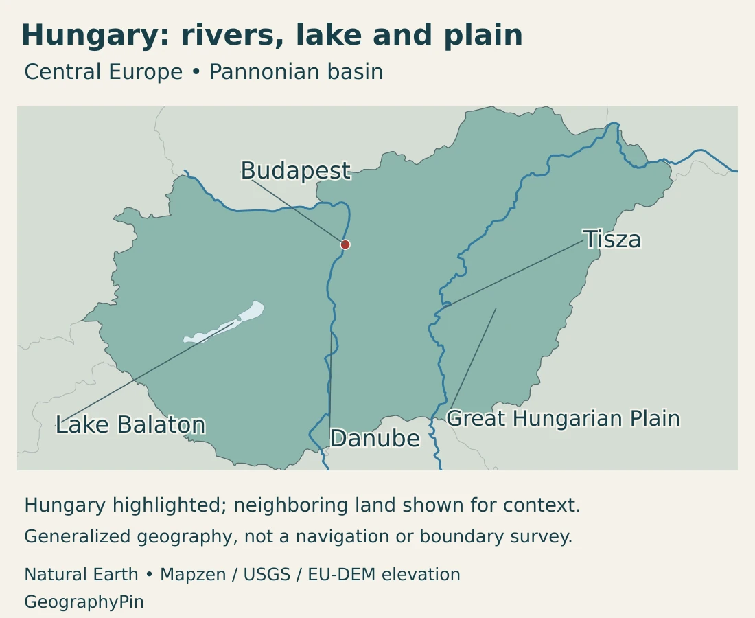
Hungary is a landlocked country in Central Europe, centered on the Pannonian basin. Budapest, its capital, spans the Danube. The Great Hungarian Plain covers much of the east and south, while hills and low mountain ranges interrupt the broader lowland setting. The Danube and Tisza connect the country to a drainage system extending far beyond its borders.
How to use this article: Compare plains and uplands, understand Lake Balaton’s setting, or follow the Danube and Tisza.
1. Locate Hungary in the Pannonian basin
Hungary borders Austria, Slovakia, Ukraine, Romania, Serbia, Croatia and Slovenia. It has no coast. Its inland position places it between the Alpine and Carpathian surroundings of the wider basin rather than within an isolated national landscape.
The Pannonian basin is a physical and geological setting extending across national borders. “Carpathian Basin” is also used for the broader regional setting enclosed by surrounding mountain systems. Neither term is a synonym for the present Hungarian state.
This distinction matters especially when reading older maps. The historical Kingdom of Hungary had different boundaries from modern Hungary. A historical outline, a cultural region and the current sovereign state answer different questions; the maps here depict the present country.
Our Europe country map places Hungary among its neighbors. The European countries and capitals guide provides the wider political reference.
A capital on contrasting banks
Budapest lies on both sides of the Danube. Buda’s hills rise on the western, right bank, while Pest occupies flatter ground on the eastern, left bank. Bridges connect these contrasting urban landscapes within one capital.
The river is therefore both a physical division and a central organizing feature of the city. The distinction between the two banks remains visible in the terrain even though Buda, Pest and Óbuda became a unified city in the nineteenth century.
2. Country facts with dates and definitions
| Measure | Value | Date or definition |
|---|---|---|
| Capital | Budapest | Capital under the Fundamental Law. |
| Population | 9,488,428 | Resident population at January 1, 2026, in the national statistical series. |
| Area | About 35,917 sq mi (93,025 km²) | KSH territorial table for January 1, 2026; published national area. |
| Official language | Hungarian | Minority-language rights and Hungarian Sign Language protection have separate legal provisions. |
| Currency | Hungarian forint (HUF) | Hungary is an EU member but does not use the euro as its national currency. |
| Government | Parliamentary republic | President as head of state; prime minister heads the government. |
| Administrative structure | 19 counties and Budapest | The capital has separate status; statistical planning regions are a different classification. |
The population estimate is based on the 2022 census and subsequent demographic updates. It is not a new census conducted in 2026. Budapest’s municipal population is also different from the population of its wider urban and commuting area.
The area follows the Hungarian Central Statistical Office’s dated territorial table. Other international summaries publish slightly different geographical-size figures. The value here is not relabeled as a separately measured dry-land area, and it is not used to calculate a mixed-source population density.
3. Plains, hills and the Balaton landscape
The lowland country is not uniformly flat
| Setting | Landscape | Why it matters |
|---|---|---|
| Great Hungarian Plain, or Alföld | Extensive low terrain across the east and south, including the country between the Danube and Tisza. | Agriculture, grasslands, floodplains and towns share a landscape with important local soil and water differences. |
| Little Hungarian Plain, or Kisalföld | Northwestern lowlands associated with the Danube and Rába system. | A distinct lowland setting around Győr, not simply the northern end of the Great Plain. |
| Transdanubian hills and mountains | Varied country west of the Danube, including uplands, basins and the Balaton area. | Creates contrasts in land use, scenery and routes within western Hungary. |
| North Hungarian Mountains | Ranges including the Mátra and Bükk north of the Great Plain. | Forested slopes, volcanic and limestone terrain contrast with the lower basin floor. |
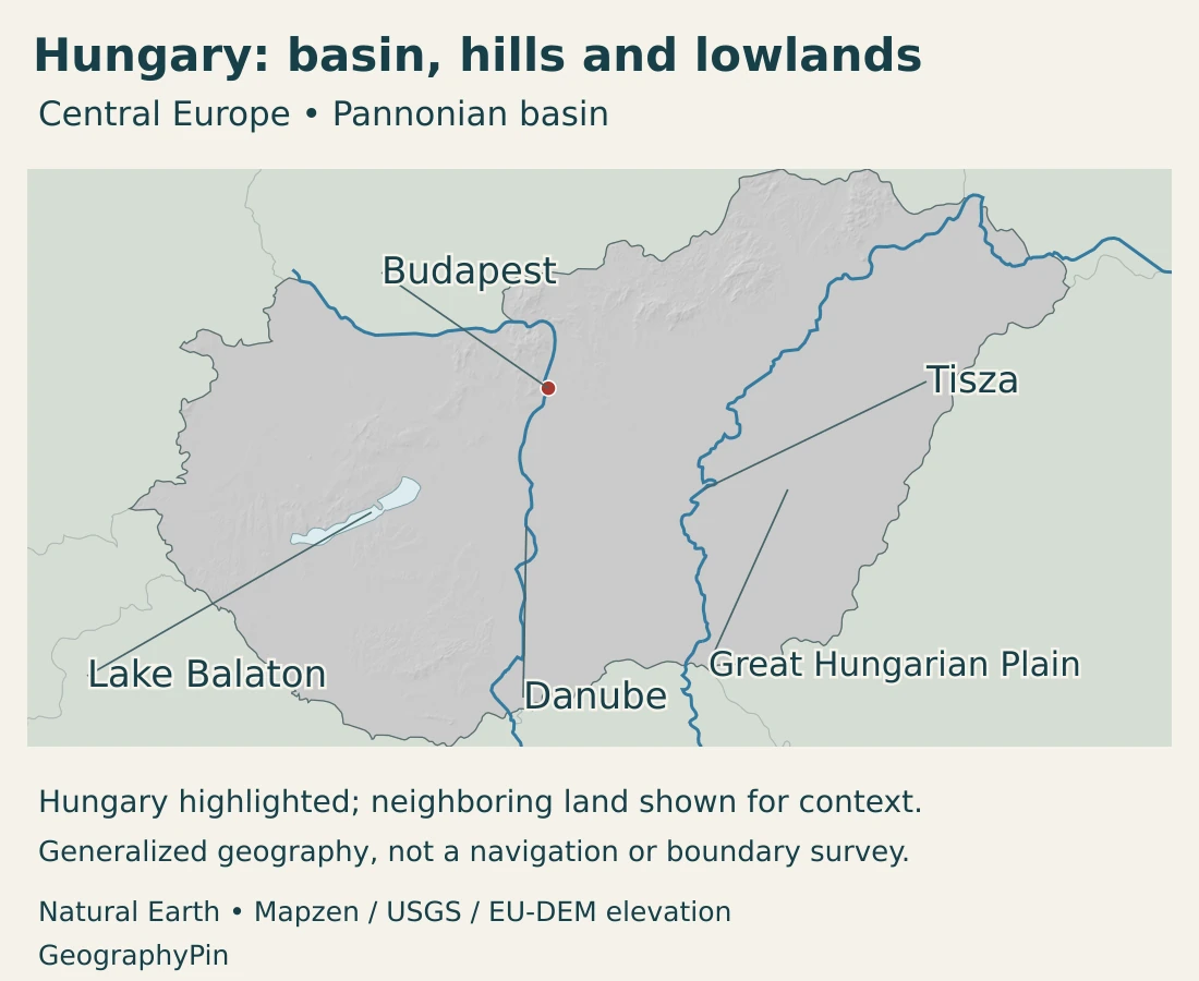
Much of Hungary is low-lying, but its uplands are real mountain landscapes rather than just gentle rises on a plain. Kékes, in the Mátra Mountains, reaches about 3,327 feet (1,014 meters), the country’s highest point.
The northern ranges also differ geologically. The Mátra includes volcanic rocks, while the Bükk has extensive carbonate-rock and karst landscapes. Their valleys, slopes and plateaus reflect different materials and landform histories, not one uniform type of mountain.
On the lowlands, small differences in elevation can still be important. Old river channels, floodplain surfaces, sandy ground and wetter depressions influence soils and vegetation. A flat-looking horizon does not mean that every field has the same drainage or agricultural potential.
Hortobágy is a cultural landscape, not an empty wilderness
Hortobágy, on the Great Plain, combines grassland, wetland and pastoral landscapes. Its open appearance reflects both environmental conditions and a long history of livestock grazing. UNESCO recognizes it as a cultural landscape rather than a place untouched by people.
River regulation changed parts of this environment, while remaining floodplain woods, marshes and abandoned channels preserve other habitats. The national park’s descriptions show a mosaic of land and water, not an uninterrupted dry grassland covering all of eastern Hungary.
A broad, shallow lake within western Hungary
Lake Balaton is a freshwater lake, not a sea or an ocean inlet. Its broad surface and shallow water distinguish it from deep mountain lakes. The Zala is its main inflow, while the regulated Sió outlet connects the lake with the Danube drainage system.
The surrounding landscape is also varied. Along the northern side, uplands, vineyards and volcanic features contrast with the lower southern shore. On the Tihany Peninsula, fossil-bearing sediments and volcanic landforms reveal a geological history much older than today’s lake landscape.
Tihany’s small inner lakes are separate waterbodies above Balaton’s level, not bays of Balaton. That detail illustrates why a map of the shoreline alone cannot describe every water feature in the surrounding hills.
4. Climate and the Danube–Tisza water system
Hungary has a temperate climate influenced by Atlantic, continental and Mediterranean air masses. Oceanic air can bring moisture and moderated temperatures, while continental conditions can produce larger temperature contrasts. Surrounding mountain systems also shape the regional pattern.
The national weather service distinguishes warmer, drier lowland settings from cooler upland areas. These contrasts matter for vegetation, farming and water demand. A single national temperature or rainfall average would conceal important differences between a plain and a higher plateau.
Hungary can experience both floods and droughts. Those are not contradictory descriptions: high river flows and prolonged local dry conditions occur at different times and can affect different places. Water availability depends on season, rainfall, upstream inflows and management, not only on the number of rivers shown on a map.
The Danube and Tisza belong to one larger system
The Danube crosses Hungary and passes through Budapest. The Tisza is the other great river of the country’s lowlands, continuing southward beyond Hungary before joining the Danube in Serbia. They are not two independent rivers flowing to different seas.
Hungary’s river-basin planning falls within the international Danube basin. The Danube River map follows the wider route toward the Black Sea and helps distinguish a national river reach from the entire international system.
Much of Hungary’s freshwater arrives from outside its borders. Upstream rainfall, river conditions and water use therefore influence conditions downstream. National water management depends on cooperation across borders as well as decisions within Hungary.
Embankments, straightened channels, reservoirs and other works have changed river behavior and floodplain connections. A managed river corridor can support transport, farming or settlements while also creating ecological tradeoffs. The remaining wetlands are part of this changing system, not disconnected patches beside it.
5. Budapest, regional cities and languages
Budapest is the national capital and a major concentration of institutions, services and cultural activity. Its administrative boundary does not include every settlement connected to it by commuting. The capital, its built-up area and a statistical region should not be treated as interchangeable units.
Beyond Budapest, the urban network includes centers with different geographic roles. Győr belongs to the northwestern lowland and manufacturing setting; Debrecen is an eastern center on the Great Plain; Szeged occupies a southern Tisza setting. Hungary’s towns are not all clustered along the Danube.
Rural land use also varies. Cultivated fields, grazing land, vineyards, woodland and wetland occupy different parts of the basin. Their distribution depends on soils, water and slope as well as the history of settlement and land management.
Hungarian and the rights of nationalities
Hungarian is the official language. The Fundamental Law also recognizes rights for nationalities living in Hungary, including the use of their mother tongues and cultural and educational rights. Hungarian Sign Language is protected separately.
These provisions describe legal roles, not a claim that every resident has the same language background. A national population estimate counts residents under its statistical definition; it is not a total for one language community or one ethnic identity.
6. Government and the geography of work
Hungary’s parliamentary system distinguishes the president’s role as head of state from the prime minister’s role at the head of government. The country is organized into counties and the separately administered capital, with towns and villages at the local level.
Planning-statistical regions serve a different purpose from counties. They group territory for statistical and development analysis rather than representing another set of sovereign or federal states. Physical names such as the Great Plain or Transdanubia form yet another layer.
Industry connects several regional centers
Manufacturing is not confined to Budapest. A 2026 investment-agency report identifies automotive-component production in Győr, Kecskemét and Székesfehérvár, alongside a new engineering and business-services operation in Győr. These examples show production and knowledge-based work linked across multiple towns.
Such facilities connect Hungary with wider European supply chains. Their locations depend on transport, suppliers and workers as well as physical terrain. A lowland location can make movement easier, but geography alone does not determine where a factory or research office is built.
Agriculture and recreation depend on water
The Great Plain’s agricultural landscapes and Hortobágy’s pastoral heritage show different ways of using lowland land. Cultivation is not the same activity as grazing on alkaline grasslands, and neither makes every remaining wetland expendable.
Balaton adds a different economic setting, where recreation and shoreline settlements depend on a functioning lake environment. Water quantity, water quality and the condition of the surrounding catchment are connected. Protecting the lake cannot be reduced to keeping a single shoreline at a fixed position.
Hungary is therefore more than an inland plain with a capital on a river. Its hills, managed floodplains, lakes, cities and industrial centers operate within a shared basin setting. Understanding those connections is the key to reading the country’s map.
Frequently Asked Questions
Is Hungary entirely flat?
No. Extensive plains occupy much of the country, but Transdanubian and northern uplands create distinct relief. Kékes in the Mátra Mountains is the highest point, at about 3,327 feet (1,014 meters).
Does the Tisza join the Danube inside Hungary?
No. It flows onward into Serbia before joining the Danube. Its Hungarian reach is part of a larger international river system.
Is Lake Balaton a sea?
No. Balaton is a freshwater lake within Hungary. Its popular “Hungarian Sea” nickname does not describe its physical classification, and Hungary remains landlocked.
What Did We Learn Today?
Hungary occupies a lowland-centered basin setting but includes varied hills and mountains. Budapest spans contrasting Danube banks, while the Tisza and Lake Balaton belong to the same wider drainage system. Grasslands, farms, wetlands and industrial towns are different parts of the national landscape. Modern Hungary’s borders, historical territories and the broader basin are not the same geographic unit.
Sources & Data Notes
Population refers to the January 1, 2026 resident estimate, not a new census. Area follows the KSH territorial table for the same reference date; other publications may use different vintages or conventions. Rounded unit conversions are for orientation, and no population density is calculated here.
- KSH, resident population: January 1, 2026 population; table updated September 15, 2026.
- KSH, population methodology: Annual population estimates updated from the 2022 census using demographic events and migration.
- KSH, territorial units and area: January 1, 2026 published area of 93,025 km² and territorial units. No separate dry-land measurement is inferred.
- KSH, territorial methodology: Counties, the capital and planning-statistical regions have distinct functions.
- Hungary’s Fundamental Law: Consolidated English text in force October 1, 2026: capital, language, currency and nationality rights.
- European Union, Hungary profile: Parliamentary institutions, counties and capital, and use of the forint.
- National Atlas of Hungary, relief: 2018 atlas chapter: lowlands, hills, northern ranges and their geological contrasts.
- KSH, Statistical Yearbook 2025: environment and energy: Basic geography, neighboring states and Kékes elevation. Area in the facts table follows the later January 2026 territorial table.
- HungaroMet, general climate: Climate influences and lowland–upland contrasts.
- OECD, Water Governance for Climate Resilience in Hungary, 2026: Cross-border water dependence and flood and drought challenges.
- Balaton Uplands National Park, Tihany: Sedimentary and volcanic landforms and the separate inner lakes above Balaton.
- International Lake Environment Committee, Lake Balaton: Stable physical setting, Zala inflow and Sió outlet. Historical water-quality and visitor statistics are not current measurements.
- Hortobágy National Park, flora and habitats: Grassland, wetland and floodplain habitat mosaic.
- UNESCO, Hortobágy National Park: Pastoral cultural landscape and long-term human use.
- UNESCO, Budapest World Heritage property: Contrasting Danube banks, bridges and the historical unification of the city.
- HIPA, HBPO investment, March 2026: Automotive-component locations and engineering and business services in Győr.
- European Commission, Hungary river-basin assessment, 2025: Danube river-basin district and changes associated with river engineering.
- Interreg Danube Tethys, sampling campaign in Serbia: Titel sampling location upstream of the Tisza–Danube confluence in Serbia.
Map sources and scope: Original GeographyPin maps use public-domain Natural Earth country boundaries, populated-place coordinate attributes, rivers and lakes. The outline represents modern Hungary, not the historical kingdom. Boundaries are generalized, not an official boundary survey.
Budapest uses the source city coordinates. The Great Hungarian Plain is a broad landscape label, not a surveyed regional boundary. The Danube and Tisza follow actual source river lines. Lake shapes are retained across borders rather than clipped into artificial national fragments. These water features do not depict current levels or navigation channels.
Hillshade is calculated from genuine elevations accessed through Mapzen Terrain Tiles, with no vertical exaggeration. Global elevation data courtesy of the U.S. Geological Survey. Produced using Copernicus data and information funded by the European Union – EU-DEM layers. Elevation-source attribution and terms apply. Shading is not bathymetry or a set of numerical elevation bands.
The cover uses Hungary’s national flag artwork from Commons. The intact flag retains its 2:1 proportions and appears separately from the decorative outline motif.

