Haiti’s geography is more than its position beside the Dominican Republic. Mountain ranges divide its interior into basins and valleys, while offshore islands extend the country beyond Hispaniola. Reading those landforms alongside rivers and settlement helps explain both agricultural opportunities and exposure to hazards.
Haiti occupies the western part of Hispaniola in the Caribbean and includes offshore islands such as Gonâve and Tortue. It shares Hispaniola with the Dominican Republic. Port-au-Prince is the capital. Mountain ranges, intervening basins and coastal plains shape the country, while the Artibonite watershed crosses the international border and supports an important irrigated farming region.
How to use this article: Clarify the shared-island distinction, read the physical map, explore Artibonite watershed, or check the population reference.
1. Locate Haiti and Read the Island Map
Haiti on Hispaniola
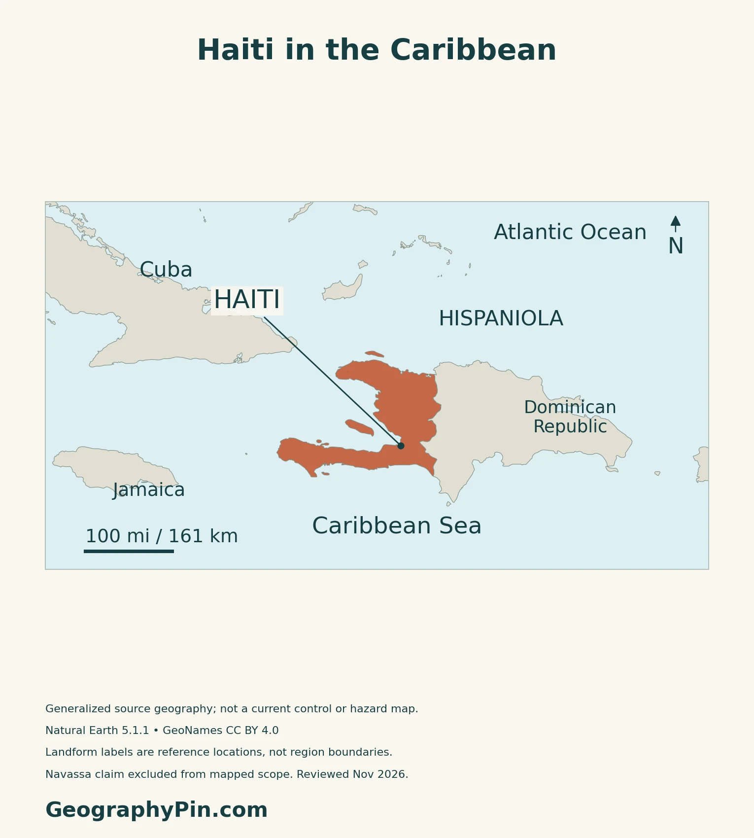
Haiti occupies the western part of Hispaniola in the Greater Antilles. The Dominican Republic occupies the eastern part of the same island. Haiti also includes offshore islands such as La Gonâve, Tortue and Île à Vache. Port-au-Prince, beside the Gulf of Gonâve, is the capital.
One island, two countries
Hispaniola is the name of the shared island, not another name for either country. The land boundary separates Haiti from the Dominican Republic, while mountain systems and river basins extend beyond national divisions. The Caribbean countries and territories map shows the wider regional setting.
2. Mountain Ranges, Basins and the Physical Map
Read the landscape as several connected regions
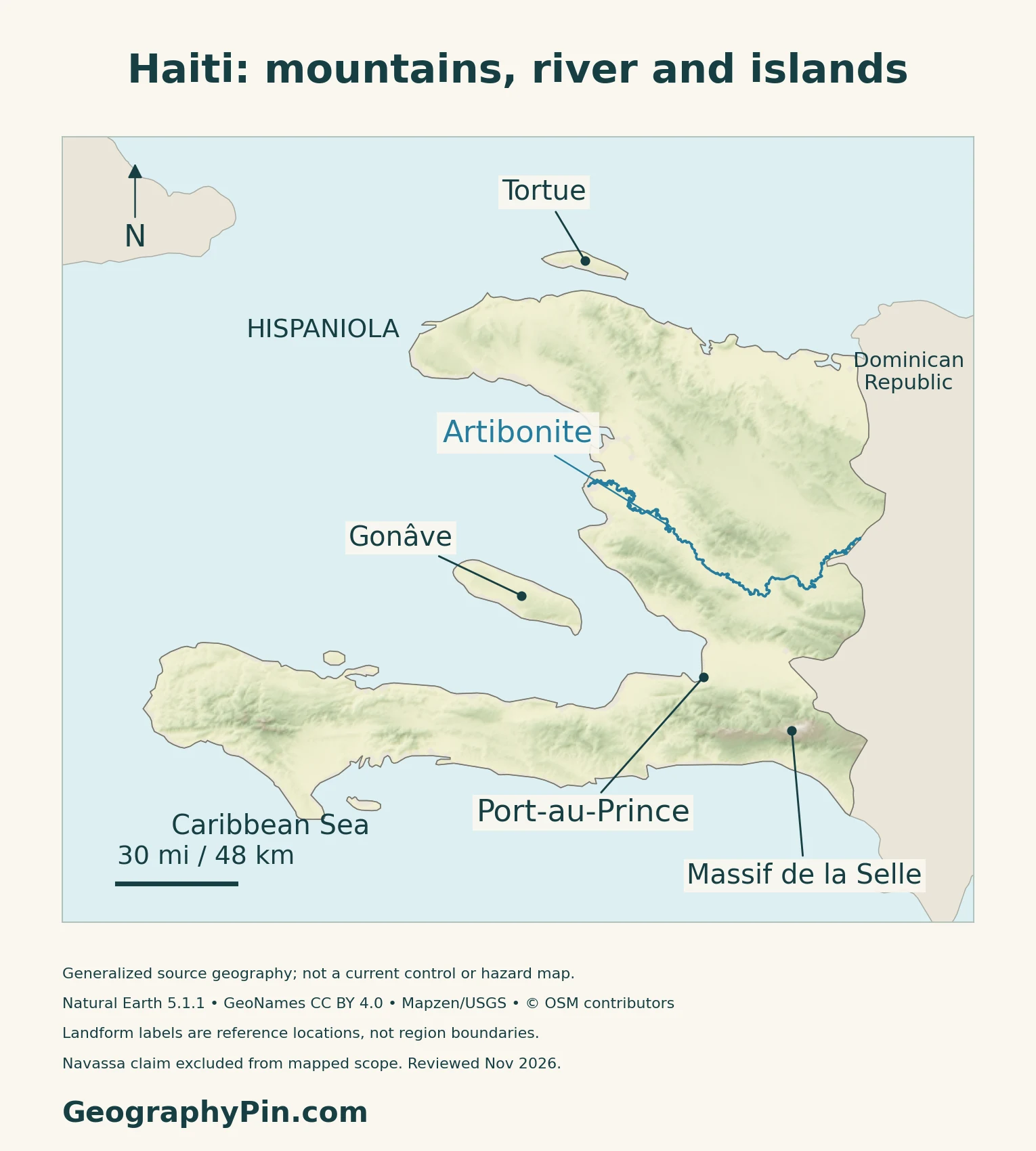
| Region | Landscape | What to notice |
|---|---|---|
| Northern and central Haiti | Alternating ranges, plateaus and alluvial plains | Ranges divide the interior |
| Artibonite valley | River valley and irrigated agricultural lowlands | Its water system extends across the national border |
| Cul-de-Sac | Low basin associated with the Port-au-Prince urban area | Separates northern landforms from the southern mountain system |
| Southern peninsula | Massif de la Selle in the east and Massif de la Hotte farther west | Highlands, catchments and coastal settlements occupy different elevations |
La Selle and La Hotte are distinct southern highlands
The Massif de la Selle contains Haiti’s highest peak, Pic la Selle. Farther west, the Massif de la Hotte forms another important highland environment. UNESCO identifies these southern mountain landscapes as places of notable biodiversity and endemism, meaning that some species have restricted natural ranges.
La Selle became a biosphere reserve in 2012. Its ecological connection with the Dominican Republic’s Jaragua–Bahoruco–Enriquillo reserve shows why conservation can require cooperation across a political boundary. A biosphere designation is not the same as inscription on the World Heritage List.
Faulting and folding help explain the relief
Haiti’s disaster-management plan describes varied volcanic, intrusive, metamorphic and sedimentary formations shaped by folding and faulting. Basins and coastal plains interrupt the mountainous terrain.
3. The Artibonite, Rainfall and Water Management
A shared watershed with an agricultural role
The Artibonite watershed connects Haiti and the Dominican Republic. A river basin is the area that drains into a river and its tributaries, so its limits need not follow the border between countries. Canada’s documented watershed-rehabilitation project, which ended in 2012, treated the border region as a shared management problem.
Downstream, the Artibonite Valley supports extensive irrigation and rice cultivation. The Inter-American Development Bank identifies erosion, flooding and dependable irrigation supply as linked challenges there. Water and sediment management matter together: farms need water at the right time, while floods can damage fields and infrastructure.
Rainfall varies with season and mountain exposure
Haiti has a tropical climate, but rainfall is not distributed evenly. FAO’s country description identifies two broad rainy periods, April–June and October–November. These are national guideposts rather than an identical calendar for every valley and coast.
The national disaster-management plan emphasizes altitude and the orientation of mountain slopes toward the northeast trade winds. The southern peninsula is generally wetter than the sheltered western side of the northern peninsula. Mountains are also cooler than lowlands.
Water connections also extend underground
The Organization of American States has documented shared groundwater systems in the Artibonite and Massacre regions of Hispaniola. Aquifers store and transmit water below ground; they are not interchangeable with surface rivers.
4. Settlement, Hazards and Economic Connections
Port-au-Prince is a city within a wider urban region
A capital label is a point on a map, but the urban region extends beyond that point. UNDRR’s 2023 assessment describes a concentration of population, infrastructure and economic activity in the Ouest department, particularly around Port-au-Prince, Carrefour, Delmas and Pétion-Ville. Those places should not be treated as one municipality when comparing statistics.
Transport links between settlements, farms and markets are part of the country’s economic geography. Their usefulness depends on infrastructure and access as well as the shape of the terrain.
Physical hazards and human exposure are different questions
Hispaniola lies in the active boundary region between the Caribbean and North American plates. Earthquake risk is distinct from hurricane or rainfall risk: strong shaking does not require a storm.
USGS mapping published in 2016 documented landslides triggered by the January 12, 2010 magnitude 7.0 earthquake. Their distribution reflected interactions among rock and soil conditions, slopes and shaking, rather than one simple cause. This is evidence from a specific historical event, not a forecast of the next earthquake.
Exposure also depends on where people and infrastructure are located. Building quality, drainage, land-use planning and the ability to prepare and respond affect how a physical event becomes a disaster. The separate Caribbean hurricane-risk guide covers the regional storm context without turning this country map into a current warning map.
Agriculture, markets and routes beyond the capital
In its September 2026 economic assessment, the World Bank highlighted potential in export crops such as cocoa, vetiver, mangoes and coffee, alongside Haiti’s proximity to major markets. It also emphasized job creation, remittance flows and access to trade markets.
The report recommended investment in northern and southern economic corridors and reconnecting the capital. Those are policy priorities, not a claim that the proposed works have been completed. Geography creates opportunities and constraints, but security, finance and institutions also shape whether people can use them.
5. Dated Country Facts and Administrative Scope
| Item | Reference | Date or scope |
|---|---|---|
| Capital | Port-au-Prince | Constitutional capital and government seat |
| Population | About 11.87 million | IHSI-published mid-2024 estimate using CELADE projections |
| Surface area | About 10,714 sq mi (27,750 km²) | UN reference, 2023; not maritime jurisdiction |
| Official languages | Haitian Creole and French | Constitution, Article 5 |
| Currency | Haitian gourde (HTG) | National currency |
| Government | Republic under transitional governance | Prime minister and Council of Ministers exercise executive responsibilities |
| Administrative divisions | Ten departments | Administrative geography, not a security-control map |
An estimate, not a new census
IHSI’s July 2024 publication draws its national total from CELADE’s 2022 revision of long-term population estimates and projections. The report explains that the last census was in 2003 and that insecurity and weak demographic records constrain measurement. It treats the figures as approximate magnitudes, not replacements for fresh field data. The estimate should not be read as a live count of residents in particular neighborhoods.
Keep institutions and administrative geography distinct
The Transitional Presidential Council’s mandate ended on February 7, 2026. The prime minister and Council of Ministers assumed executive responsibilities; the government’s October 2026 budget account still describes electoral preparations and institutional restoration as ongoing tasks.
The ten departments are Artibonite, Centre, Grande-Anse, Nippes, Nord, Nord-Est, Nord-Ouest, Ouest, Sud and Sud-Est.
What Did We Learn Today?
Haiti is a country on western Hispaniola with offshore islands, not the name of the whole island. Its mountains, basins and coastal plains support different patterns of farming and settlement. The shared Artibonite watershed illustrates cross-border environmental connections, while population figures and urban labels need dates and clearly defined geographic coverage.
Sources & Data Notes
Population is IHSI’s published mid-2024 estimate from CELADE projections, not a new census or live neighborhood count. Surface area follows the UN’s 2023 reference. Constitutional capital and language provisions are distinguished from transitional executive arrangements documented in 2026 and corroborated by the OIF’s November 15–16 resolution. The national disaster-management plan covers 2019–2030; the USGS landslide example concerns the 2010 earthquake, and UNDRR’s urban analysis dates from 2023. World Bank recommendations reported in September 2026 are not completed infrastructure works. Biosphere-reserve designation is distinct from World Heritage inscription.
- IHSI: disaggregated population estimates for 2024
- IHSI: projections and population estimates
- UNData: Haiti country profile and statistical references
- Haitian Constitution: capital, languages and state geography
- IACHR: transitional governance, March 9, 2026
- Government budget office: Council of Ministers, October 2, 2026
- OIF: Phnom Penh resolution, November 15–16, 2026
- MICT: national disaster-risk management plan 2019–2030
- UNESCO: La Selle biosphere reserve
- FAO Haiti: general geographic and agricultural context
- Global Affairs Canada: Artibonite watershed project, 2005–2012
- IDB: Artibonite irrigation and flood-management context
- OAS: shared groundwater systems of Hispaniola
- UNDRR: Haiti disaster-risk analysis, 2023
- NASA Earth Observatory: tectonic setting of southern Haiti
- USGS: landslide mapping for the January 2010 earthquake
- World Bank: economic corridors and market connections, September 2026
Map method: Original GeographyPin maps use Natural Earth 1:10m countries version 5.1.1, public domain. Haiti’s mainland and four offshore source components are retained; the Navassa claim is outside the depicted scope, including the cover. This is not a complete legal inventory or a current-control map. Place and landform reference locations use GeoNames under CC BY 4.0; mountain markers are not drawn region boundaries. Shaded relief uses actual Mapzen Terrain Tiles with USGS and upstream attribution. Negative elevation samples and a small buffer are omitted, not replaced with invented heights; this is not a detailed map of below-sea-level depressions. Artibonite segments come from WaterwayMap’s OpenStreetMap-derived geometry, © OpenStreetMap contributors, ODbL. The mapped Haitian reach is not the complete transboundary course or watershed, and no missing segments are fabricated. The clean cover uses FlagCDN flag artwork with a complete coat of arms and separate intact national flag, checked against constitutional design provisions. No endorsement is implied.