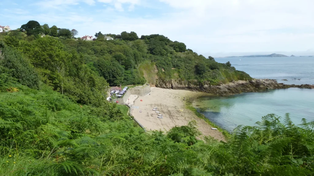
A map centered only on Guernsey can leave much of its bailiwick off the page. Alderney and Sark belong to the same Crown Dependency, yet they have separate governments. Across these islands, cliff-backed coasts and low-lying shores create different landscapes, while large tides repeatedly change how much of the coastal edge is exposed.
Guernsey is a Channel Island and the largest island in the Bailiwick of Guernsey, a self-governing Crown Dependency outside the United Kingdom. The bailiwick contains three jurisdictions: Guernsey, Alderney and Sark. Its geography combines plateaus, cliffs, lower coastal ground and extensive tidal shores; St Peter Port stands on Guernsey’s east coast.
How to use this article: Compare the three jurisdictions, explore the island landforms, or understand Lihou’s tidal connection.
1. Locate the Island and the Wider Bailiwick
The Bailiwick of Guernsey lies in the English Channel, in the Gulf of Saint-Malo near France. Guernsey is its largest island, but the place name also appears as shorthand for the wider jurisdictional group. Those uses need separating before interpreting a map, an area measurement or a population total.
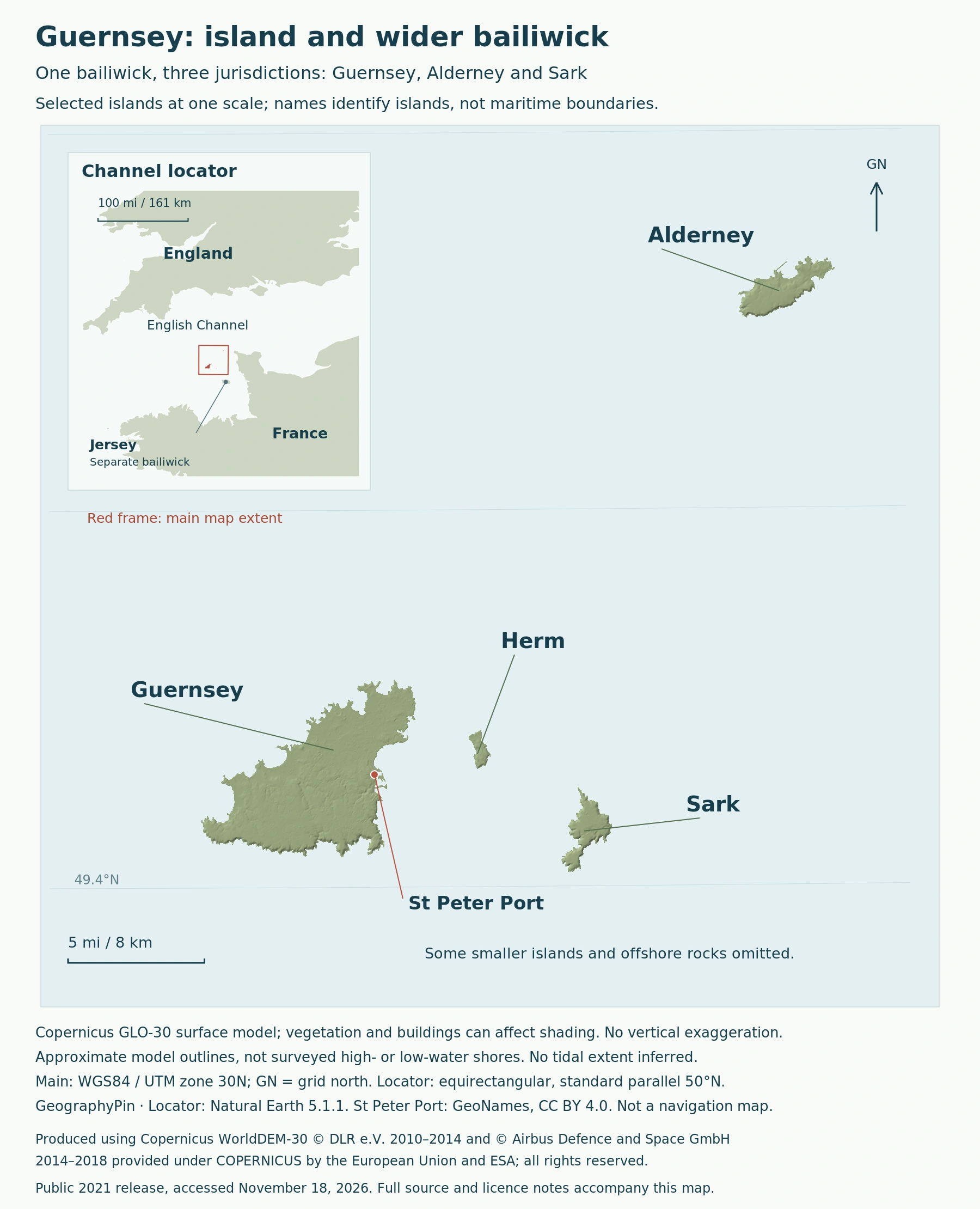
St Peter Port provides a useful starting point on the main island’s east coast. Herm and Sark lie offshore to the east, while Alderney is farther northeast. The map should be read as an island group separated by sea, not as one continuous landmass with districts drawn across it.
Jersey belongs to the Channel Islands too, but it is a separate bailiwick. Shared geography does not create a single Channel Islands government. Likewise, “Guernsey” in a source may refer to the main island or a wider administrative coverage: the label alone is not enough to establish what has been counted.
2. Three Jurisdictions Within One Crown Dependency
Guernsey, Alderney and Sark
Government House identifies Alderney and Sark as separately governed within the bailiwick. Their institutions are not simply branches of a municipal administration in St Peter Port. The main legislative bodies make the distinction visible:
| Jurisdiction | Legislative body | Scope note |
|---|---|---|
| Guernsey | States of Guernsey | Includes Herm and Jethou as well as the main island. |
| Alderney | States of Alderney | A separate island jurisdiction within the bailiwick. |
| Sark | Chief Pleas of Sark | Its jurisdiction includes Brecqhou. |
A House of Lords account distinguishes these jurisdictions and their legal and fiscal systems. The three-row table is therefore an administrative comparison, not a complete inventory of every island, rock or reef. Counting jurisdictions gives three; counting physical islands answers a different question.
The shared connection is to the Crown. Guernsey’s constitutional status does not make it part of the United Kingdom, and Crown Dependencies are not British Overseas Territories. The UK has responsibilities for defense and international relations, while the islands maintain their own governing institutions.
3. Plateaus, Cliffs and Lower Coastal Ground
Similar settings, varied coastlines
The JNCC-published environmental assessment describes plateau landscapes on the major islands, with lower ground on Guernsey, Alderney and Herm. Cliffs border all or part of the larger islands, but they do not form an unbroken wall around every shore. Dunes, coastal grassland and wetland habitats contribute to the contrast.
The underlying rocks also vary. The assessment identifies metamorphic gneiss and areas of granite, with substantial sandstone areas on Alderney. It is more accurate to describe this mixture than to call the entire bailiwick one granite island.
On Guernsey, woodland on steep slopes and marshy or reed-covered ground add smaller-scale differences to the relief. The coastline is not one uniform landscape repeated around an outline.
4. Lihou and the Changing Tidal Shore
An island linked by a tidal causeway
Lihou, off Guernsey’s west coast, makes the effect of tides especially clear. A causeway connects it to the main island only during suitable low-water periods. VisitGuernsey describes access as tide-dependent; the presence of a mapped connection does not make it an all-day land route.
The Ramsar information sheet for Lihou Island and L’Erée Headland describes a spring tidal range of about 33 feet (10 m). This is a difference between high and low water, not a wave height. Together with the gently sloping shore, it helps explain the broad intertidal area exposed as the sea retreats.
The protected site is a collection of connected habitats rather than just the dry land of Lihou. The island’s managing charity describes rocky shores, sandy areas, a shingle bank and coastal wetlands within the designated area. These different surfaces create a coastal mosaic that a simple land-and-sea outline cannot fully show.
Ramsar designation concerns wetland conservation. It is not a political boundary, and it should not be used to decide where one island jurisdiction ends and another begins. For the same reason, a low-tide photograph illustrates the shore’s appearance at that moment, not a permanent expansion of the bailiwick.
5. St Peter Port and the Island Group
St Peter Port is Guernsey’s capital and an important harbor town on the east coast. The official tourism office describes it as the bailiwick’s island-hopping center, looking toward Herm and Sark. Its waterfront helps show how the sea connects the islands as well as separates them.
The town also rises above its waterfront. Hauteville House occupies higher ground overlooking the Channel, while Castle Cornet stands in the harbor. These landmarks give a compact picture of St Peter Port’s setting: elevated urban ground behind a working coastal frontage, with neighboring islands visible offshore.
What Did We Learn Today?
Guernsey is both the name of the bailiwick’s largest island and a term whose administrative scope needs checking. Guernsey, Alderney and Sark form three jurisdictions within one Crown Dependency, while Jersey is separate. Their varied relief and tidal shores explain why a useful map needs more than a single island outline, and why St Peter Port’s connections should not be mistaken for common local government.
Sources & Data Notes
Sources, dates and map conventions
The institutional comparison follows Government House and the parliamentary explanation of the three jurisdictions. The 2011 environmental assessment supports qualitative landforms, not present-day population figures. The Lihou tidal-range figure refers to spring tides at the described site. Map data and the dated photograph have separate attribution; neither supplies current crossing times.
Produced using Copernicus WorldDEM-30 © DLR e.V. 2010-2014 and © Airbus Defence and Space GmbH 2014-2018 provided under COPERNICUS by the European Union and ESA; all rights reserved. The organisations in charge of the Copernicus programme by law or by delegation do not incur any liability for any use of the Copernicus WorldDEM-30. Copernicus data licence. This is an independent rendering, not a provider endorsement. Surface shading may include buildings and vegetation; model outlines are not surveyed high- or low-water shores.
- Government House: the bailiwick and its governing institutions
- House of Lords: Crown Dependencies and the three jurisdictions
- Ministry of Justice: Crown Dependencies
- JNCC: Guernsey environmental assessment appendices, 2011
- Ramsar: Lihou Island and L’Erée Headland information sheet
- The Lihou Charity: Ramsar site habitats
- VisitGuernsey: Lihou and its tidal connection
- VisitGuernsey: St Peter Port
Featured photo: Fermain Bay, Guernsey, August 19, 2012. Rumburak3 / Wikimedia Commons, CC0; resized and converted to WebP.
