Iceland’s Golden Circle ties together a national park, a field of geysers and a waterfall in the southwest. The three main stops are easy to name, but knowing where to park, where to turn back and which detours fit the return drive makes the map more useful.
Drive out through Þingvellir and return toward Selfoss
A park-first Golden Circle drive from Reykjavík goes to Þingvellir National Park, then to Geysir and Gullfoss. From the falls, turn back on Road 35 and take the lowland return toward Selfoss and Route 1. Kerið crater is optional; it fits that return better than a separate trip from the park.
How to use this article: Find the best Þingvellir lot for your walk, check which Gullfoss lot you can use, choose the detour that fits your return, or confirm where to reboard a coach.
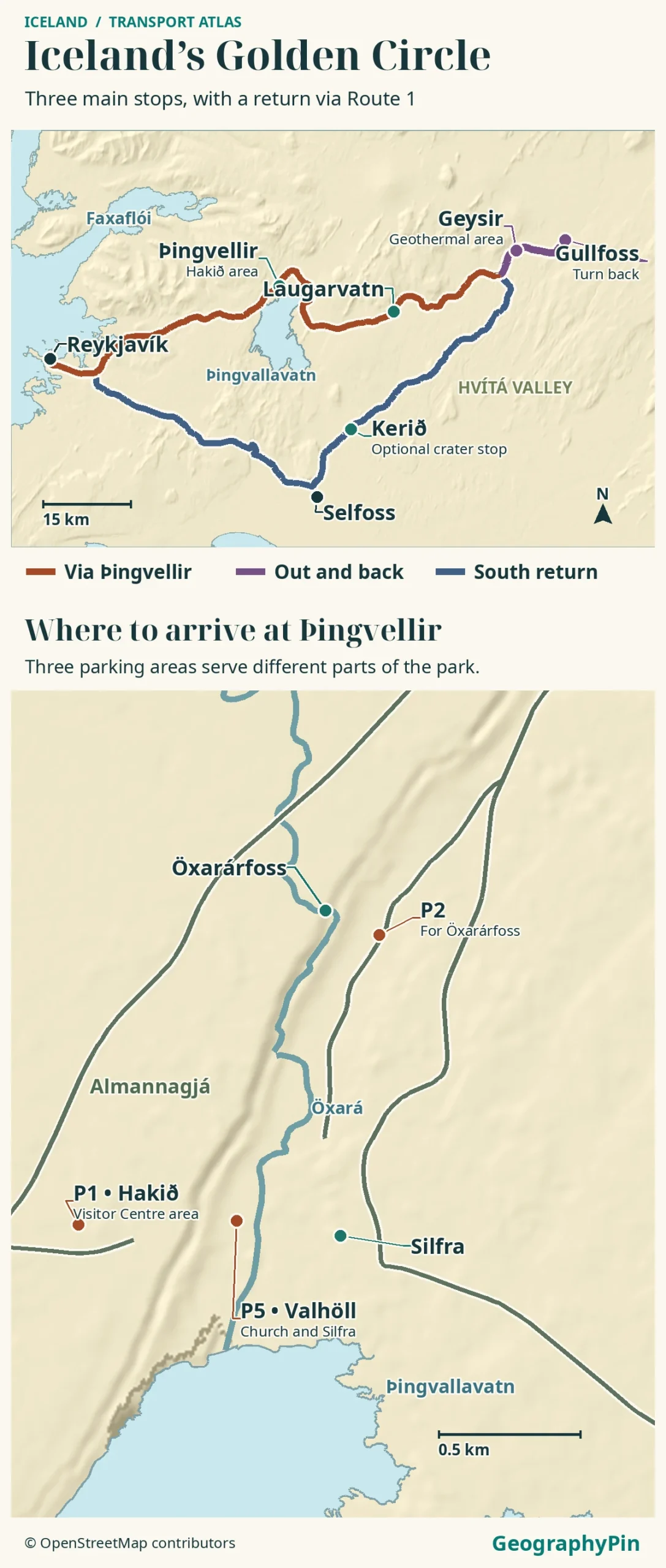
Golden Circle map and driving legs
The Golden Circle is a sightseeing route, not a single numbered road. The map shows one way to drive it from Reykjavík, with Þingvellir first and a southern return. You can reverse it or join from the Selfoss side. It is not the Ring Road, although this version uses Route 1 to link the other roads.
| Leg | Roads | Arrival point |
|---|---|---|
| Reykjavík → Þingvellir | Route 1 toward Mosfellsbær, then Road 36. | Hakið P1 for the park’s upper viewpoint; choose P2 or P5 for a different walk. |
| Þingvellir → Geysir | Road 36, then 365 across Lyngdalsheiði; continue via Laugarvatn on 37 to Road 35. | Geysir geothermal area in Haukadalur, not a pin for a single spring. |
| Geysir → Gullfoss | Stay on Road 35, then take the signed waterfall approach. | Upper car park for general visitors; the lower lot is designated separately. |
| Gullfoss → Reykjavík | Turn back on Road 35; use the Route 1 junction near Selfoss for the westbound return. | Kerið works as an optional stop on Road 35. You need not go into central Selfoss. |
Road, access and operator information checked November 20, 2026. The road authority puts its Þingvellir service-center-to-Geysir route via Laugarvatn at about 35 miles (56 km) and Geysir to Gullfoss at about 6 miles (10 km). The first figure starts at Leirar, not at Hakið P1. Neither figure includes parking, walks or a detour. Set the exact pins and budget those separately rather than treating any one total as the length of the Golden Circle.
Þingvellir: Choose a parking area
P1 for the overlook, P2 for Öxarárfoss, P5 for the church
Hakið P1 is the simplest first stop for the lake outlook and upper end of Almannagjá gorge. It serves the visitor center at the upper viewing area. For a shorter first look, decide at the overlook whether you want to walk farther down into the gorge rather than assuming the whole historic site is on the upper terrace.
The park lists Efri-Vellir P2 below and east of Öxarárfoss. It lists Valhöll P5 as the nearest lot to Þingvellir Church and the Silfra fissure. These arrival points serve different plans: a look at the gorge from above, a waterfall walk, or time at the lower historic site. In icy conditions a short map distance does not tell you how easy a walk will be.
The park says one service-fee payment covers P1, P2 and P5 on the same day. You do not have to pay separately at each of those three lots for a same-day visit. Leirar, the service center by the campground, is not the same as the visitor center at Hakið. Saving both as one destination can send you to the wrong starting point.
Geysir: Find the geothermal field in Haukadalur
Laugarvatn is on the direct cross-country leg from Þingvellir to Geysir. Continue through the village and along Road 37 toward Road 35 rather than adding a long out-and-back. A stop in Laugarvatn fits this leg; time at a site there is separate from the drive.
On Road 35, aim for Geysir geothermal area in Haukadalur. The protected site contains several hot springs and geysers, including the Great Geysir and Strokkur. “Geysir” on a sightseeing itinerary usually means this whole stop. Strokkur is the one to look for when you see an erupting geyser mentioned by a tour operator; do not plan your departure around a guaranteed interval.
Use the signed visitor approach and stay inside the marked walking areas. A quiet spring is still a geothermal feature, and the ropes separate visitors from hot ground and water. Leave a margin for walking between the site and where you parked or were dropped off; a road time between Geysir and Gullfoss does not cover those two walks.
Gullfoss: Pick the right waterfall approach
The upper lot is for general visitors
Gullfoss is farther along the same Road 35 corridor, on the Hvítá River. The Nature Conservation Agency directs general visitors to the upper lot by Gullfosskaffi. It designates the lower lot for buses and accessible parking. Do not treat the lower lot as overflow simply because a map displays two parking symbols.
From the upper lot, a path leads to an overlook above the falls. The canyon-side trail toward the lower views is a separate walk; follow local barriers and signs, especially where spray freezes. A road open to the parking area is not evidence that the lower trail is open.
The onward line north of Gullfoss is Kjalvegur, a highland route. It is not the continuation of this sightseeing loop. For the lowland return, drive back past the Geysir area on Road 35 and keep following the southbound corridor instead of cutting back through Laugarvatn.
Detours, coach returns and winter conditions
Fit Kerið to the return and save side-road stops for daylight
Kerið is on Road 35 toward Selfoss. On the southbound loop it is a stop off the road you are already driving, not a long detour. On an out-and-back through Þingvellir and Laugarvatn, adding the crater takes you onto a different return leg or means going away from your route and retracing it. The crater has separate paid admission; its operator describes visiting hours in terms of daylight, not a fixed year-round clock time.
Skálholt is a separate stop off Road 35 via Road 31. It adds a side-road leg if you keep the same main return, unlike simply pulling off at Kerið. If daylight is tight, choose one optional stop, not both. Of these extras, Laugarvatn on the outbound leg and Kerið on the southern return require the least departure from the mapped drive. Which costs the most backtracking depends on the return you choose and where you are staying.
No car: Confirm the pickup and final drop-off
For the three main sights without driving, a reserved sightseeing coach is the simplest single-vehicle option. Reykjavík Excursions’ Golden Circle Direct is one example. The operator describes roughly 6½ hours for the express three-stop tour and about 8 hours for its version with Friðheimar. Those are total outing times, not driving times or a guarantee of today’s departures.
Use the pickup and return point printed on your booking, such as BSÍ bus terminal in Reykjavík. A hotel pickup can be a separate stop. At each attraction, confirm the coach meeting point and time before walking away. Do not rely on the next tour to pick you up. Kerið is not listed on the basic Golden Circle Direct itinerary.
Strætó’s regional 72 and 73 schedules from October 2026 show nearby towns such as Flúðir and Laugarvatn, not a through route to all three attractions. Vegagerðin announced that these routes would no longer run in the summer and would follow the school calendars in winter. A bus to a town is not a last-mile connection to Geysir or Gullfoss. If you plan an independent bus leg, use the exact stop in the dated planner and confirm both the onward link and the return from that same area.
Before you drive, check the specific road sections on Vegagerðin’s traffic map and the Icelandic Met Office weather warnings. Check again before leaving Gullfoss if conditions are changing. The lowland return still crosses exposed ground. If a section is closed or conditions are beyond your experience, drop a stop or postpone instead of following an unverified shortcut.
Frequently Asked Questions
Does an accessible parking permit change how Þingvellir parking works?
Yes. The park says vehicles displaying a disabled parking permit are exempt, but the registration plate still has to be removed from the camera-payment system. See the park’s parking page for the visitor-center and email options.
Can I drive the Golden Circle straight from Keflavík Airport?
You can start from the airport area without stopping in central Reykjavík. It is a different starting point from the city shown on this map. Vegagerðin’s airport-to-Þingvellir entry includes Route 41 before the capital-area roads; set your exact park lot when comparing the two starts.
Can I see the historical assembly site without walking down Almannagjá?
Yes. The park’s P5 lot places you on the lower side near Þingvellir Church. The park map shows a different foot approach to the historical area. That skips the descent from Hakið but does not guarantee step-free access to every path.
What Did We Learn Today?
Þingvellir, Geysir and Gullfoss are the three main stops. Use the park lot that matches your walk, turn back from Gullfoss on Road 35, and fit Kerið to the southern return if there is daylight. For a coach outing, confirm your own pickup and return details rather than assuming the whole route runs as public transport.
Sources & Data Notes
The distances are rounded from specific Vegagerðin road legs, and the coach times are operator estimates including stops. See Visit South Iceland route overview, Vegagerðin park service center to Geysir, Geysir to Gullfoss, airport to Þingvellir, Þingvellir parking and permit rules, official park visitor map, Geysir geothermal area, Gullfoss access and parking, mountain-road season, Kerið operator, Skálholt approach, Golden Circle Direct, operator outing estimates, Strætó route changes, Vegagerðin on school-year bus service, Strætó rural timetables, SafeTravel alerts. Attraction access, road conditions and transport may change. The map does not show live closures.
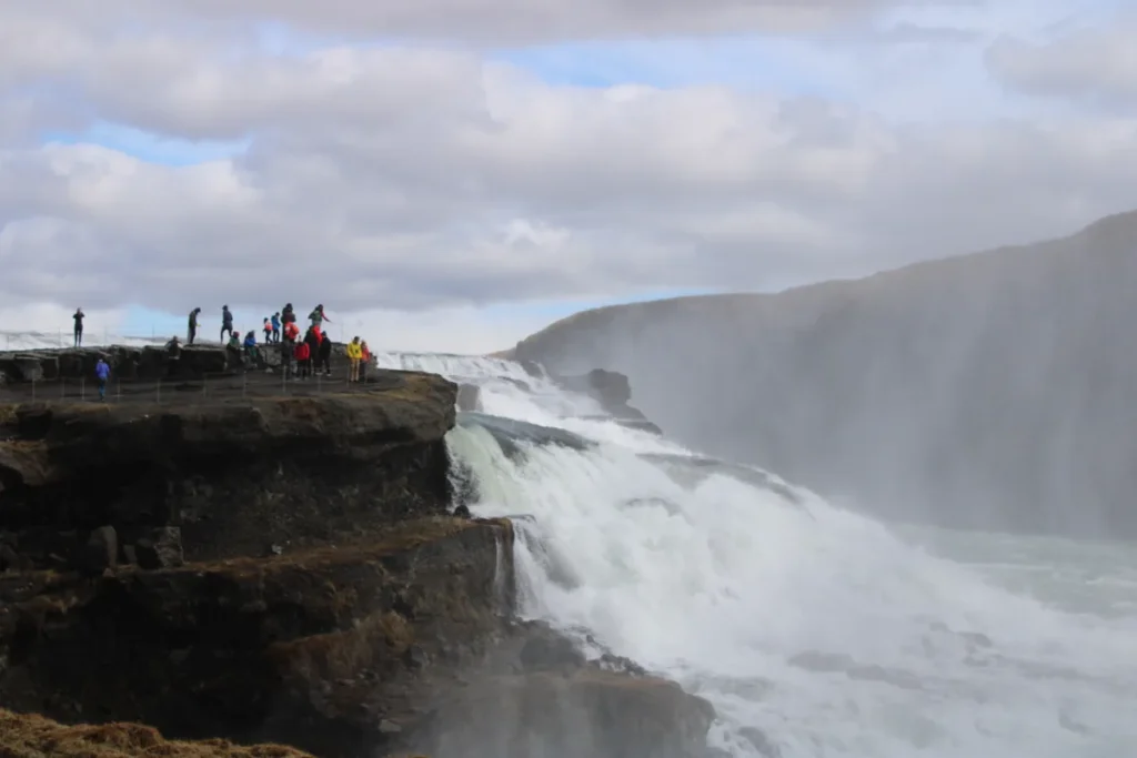
Photograph: Gullfoss Waterfall, Iceland, Chris Long / Wikimedia Commons / CC BY 2.0, May 23, 2024. Resized and converted to WebP without cropping.
The atlas uses road, coastline, lake and site data from OpenStreetMap contributors (ODbL) with AWS Open Data Terrain Tiles. It shows a representative drive, not current road, parking or walking conditions.