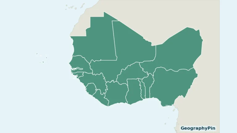
Ghana’s geography connects an Atlantic coastline with forest country, inland cities and the northern savannas. Lake Volta adds another organizing feature, but understanding the country means separating that reservoir from the much larger river system around it.
From the Gulf of Guinea to the northern savannas
Ghana is a West African country on the Gulf of Guinea, bordered by Côte d’Ivoire, Burkina Faso and Togo. Its capital is Accra. Coastal plains and southern forest landscapes give way to interior transition zones and northern savannas, while the Volta River system and Lake Volta connect water, energy, transport and livelihoods.
How to use this article: Compare the coastal environments, understand forest and savanna regions, or distinguish Lake Volta from its river basin.
1. Where Ghana is, and how to read its map
Ghana lies on West Africa’s Atlantic coast, with Côte d’Ivoire to the west, Burkina Faso to the north and Togo to the east. Its southern shore faces the Gulf of Guinea. Accra, the capital, is on that coast rather than near the geographical center of the country.

Read the map in two directions. From south to north, it connects the coastal plain with an interior that becomes increasingly dominated by savanna landscapes. From west to east, it shows a country between neighboring states, not an isolated coastal strip. The national boundary and the boundaries of river catchments serve different purposes and should not be confused.
The West Africa countries map places Ghana in its regional setting. For a continent-wide capital reference, use our African countries and capitals list; this profile explains the landscape behind that short entry.
2. Country facts, with dates attached
| Fact | Reference |
|---|---|
| Official name | Republic of Ghana |
| Capital | Accra |
| Population projection | 34,378,768 for 2026, Ghana Statistical Service national projection. |
| Latest census baseline used here | 30,832,019 people in the 2021 Population and Housing Census final results. |
| Surface area | About 92,100 square miles (238,537 square kilometers), UNData reference year 2023; surface area, not land alone. |
| Official language | English; Ghana is multilingual. |
| Currency | Ghana cedi (GHS). |
| Administrative divisions | 16 regions. |
The Ghana Statistical Service identifies the 2026 figure as a projection. It is not a new census count. Keeping the census baseline alongside it makes the distinction visible rather than presenting two different totals as contradictory measurements.
International organizations can publish different projections for the same year. Those numbers should not be averaged together: first compare the statistical series, reference date and method. Likewise, a surface-area total includes more than land alone. Lake Volta is an especially good reason not to silently change that label to “land area.”
3. Coastal plains, forest country and northern savannas
Ghana’s landscape is more varied than either “tropical forest” or “savanna” suggests. A useful broad reading separates the coast, the forest belt, the forest–savanna transition and the northern savannas. These are explanatory landscape groupings, not four official administrative regions.
| Landscape | Where to look | Important distinction |
|---|---|---|
| Coastal plains | Southern edge, including the Accra area | The eastern coastal savanna is not the same environment as the humid southwest. |
| Forest belt | Southern and southwestern interior | A broad ecological setting, not a claim that all land remains forested. |
| Forest–savanna transition | Interior between the forest belt and northern savannas | A transition with mixed characteristics, not a sharp nationwide line. |
| Northern savannas | Much of northern Ghana | Seasonal grassland and woodland landscapes, not the Sahara. |
The coast is not one uniform environment
The southwest is humid, while the eastern coastal zone is comparatively dry. That contrast matters when looking at Accra: a coastal capital does not stand for every climate and vegetation type along the country’s shore. The presence of the ocean does not make all coastal places equally wet.
FAO’s ecological descriptions distinguish coastal savanna and mangrove or coastal vegetation from the interior forest formations. A photograph of one coastal habitat therefore cannot illustrate the whole southern landscape accurately.
Forest and savanna describe more than a color on a map
Ecological regions describe broad environmental patterns. They are not a current inventory of intact vegetation. Within a forest-zone setting, towns, farms and other land uses can occupy ground that a small-scale ecological map colors green. Conversely, a savanna is not necessarily treeless: grasses and woody vegetation can occur together.
Researchers also use different climatic and ecological classifications for different purposes. A 2023 study of Ghana’s agro-climatic zones re-examined older boundaries using rainfall and temperature observations. Its findings are a reminder to treat region names as useful frameworks, not timeless, precisely surveyed borders.
4. Lake Volta is not the same as the Volta basin
Three related features, three different meanings
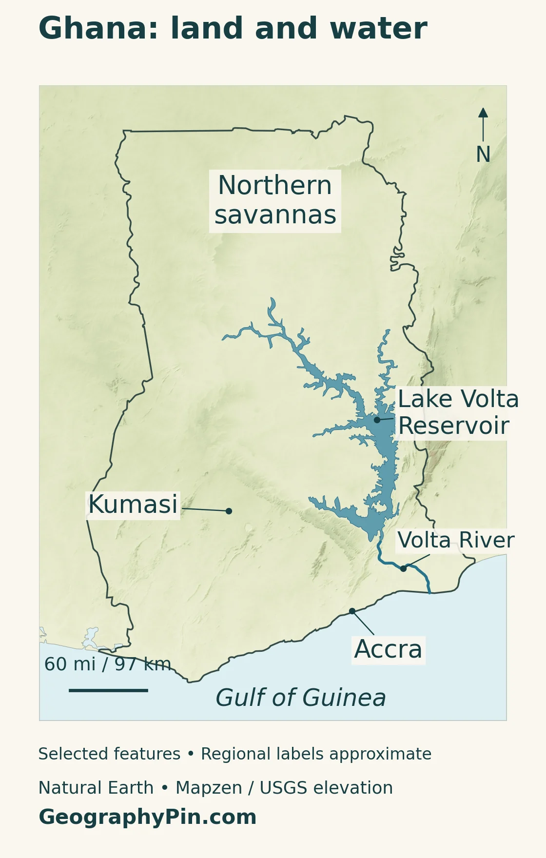
Lake Volta is a reservoir. The Volta River is a watercourse. The Volta basin is the wider area whose drainage feeds the river system. A lake outline on a map is therefore not a basin boundary, and the river’s name should not be used as though it refers only to the reservoir.
Akosombo Dam transformed this water system in the 1960s. The Volta River Authority records construction from 1961 to 1965 and identifies the plant as a storage-reservoir hydropower facility on the Volta River. Lake Volta is thus not an ancient natural lake, even though it is now a familiar geographical feature.
Its size is often used in superlatives, but “largest” needs a stated measure and comparison group. This profile avoids treating reservoir surface area, water volume and the size of a drainage basin as interchangeable records.
Water connects electricity, transport and livelihoods
The lake is more than a blue shape or a source of electricity. Ghana’s Maritime Authority describes inland navigation as important to communities around it, including places that depend on water transport for movement and livelihoods. A large reservoir can connect settlements across water while also making the shape of the shoreline important to everyday journeys.
Farther downstream, the Water Resources Commission’s Lower Volta basin work brings together agriculture, fisheries, hydropower, ecosystems and water supplies. It also identifies problems such as pollution, flooding and competition over water. These uses help explain why river management cannot be reduced to maximizing one output at a single dam.
When reading the physical map, follow the distinction between stored water and flowing water. The reservoir’s branching shoreline is not a set of separate coastal inlets: it lies inland. The lower river continues toward the sea beyond the reservoir and dam.
5. Rainfall seasons help explain regional life
Ghana has a tropical climate, but its rainfall calendar is not uniform. The Ghana Meteorological Agency describes a broadly bimodal pattern in the south, with two rainfall peaks, and a unimodal pattern in the north, with one main rainy season. These are long-term patterns, not promises about the exact start of rain in a particular year.
Moist southwesterly winds influence the wet season. Dry northeasterly winds bring dusty conditions during the dry season, commonly associated with the harmattan. Temperature and rainfall should be considered separately: a tropical location can remain warm while water availability changes markedly through the year.
For farming, this means that “Ghana’s rainy season” is an incomplete instruction. The location and crop matter, as do the timing and reliability of rainfall. For a country profile, the important connection is between regional climate and land use, rather than a single nationwide planting calendar.
Longer-term climate risks also differ by setting. GMet’s climate material discusses coastal erosion and flooding, prolonged dry spells and other changing hazards. A projected future change is not a measured condition at every location today; local decisions require local observations and forecasts, not just a national overview.
6. Cities, population and languages
Accra is Ghana’s capital, but it is not a substitute for the country’s entire urban geography. Kumasi is a major inland commercial center in Ashanti, giving the map a second important reference point away from the coast. Together, the two cities help connect southern coastal and interior settlement rather than suggesting that urban life stops at the shoreline.
The 2021 census found 56.7% of the population living in urban areas. Greater Accra, Ashanti, Eastern and Central regions together held more than half the national population. These are regional statistics, not population totals for four individual cities.
That distinction matters particularly for Accra. A city, a wider built-up area and an administrative region can have different boundaries. Comparing a regional total for one place with a municipal total for another can produce a misleading city ranking even if both numbers were copied correctly.
English is the official language and is widely used in government and business. It does not make Ghana monolingual. Ghanaian languages remain central to everyday communication and cultural life; official-language status and the language someone uses at home answer different questions.
Language totals also depend on classification. A list of languages standardized for official educational or publishing work is not necessarily a complete inventory of all languages spoken in the country. This profile therefore avoids turning an administrative language list into an unsupported national language count.
7. Government and the geography of the economy
Ghana is a republic governed under the 1992 Constitution. Article 57 places the roles of head of state and head of government in the presidency. Parliament and the judiciary are separate constitutional institutions; describing Ghana’s government requires more than naming the current officeholder.
The country’s 16 administrative regions are political and administrative units. They should not be confused with the ecological regions in the landscape table or the river basins used for water management. One location can belong to all three types of region at once.
Ghana’s economy includes services alongside agriculture, mining and oil and gas. Gold, cocoa and oil are important export products, but an export list alone is not a complete description of how people work or how cities function. Trade, transport and other services link producing areas with consumers and markets.
The geographical questions are therefore practical: where are crops grown, how do settlements connect, and how is water shared between competing uses? The forest belt, savannas, coast and Volta system give those questions a spatial framework. They help explain differences within Ghana without reducing the country to a single resource or industry.
Frequently Asked Questions
Is Lake Volta a natural lake?
No. It is a reservoir created by the Akosombo Dam project in the 1960s. It forms part of the wider Volta River system, but its shoreline does not mark the boundary of the Volta basin.
Is all of southern Ghana rainforest?
No. Southern Ghana includes forest environments and coastal savanna, with the eastern coast comparatively dry. An ecological forest zone also does not mean every part of it remains covered by intact forest.
Why are Ghana’s census and current population figures different?
The 2021 census counted the population at a particular time; the 2026 figure used here is a GSS projection. They refer to different years and different statistical methods, so neither should be relabeled as the other.
What Did We Learn Today?
Ghana’s geography is a connected pattern of coast, forest landscapes, interior transition and northern savannas. Accra and Kumasi provide contrasting settlement reference points, while Lake Volta shows how a reservoir can reshape water use and transport. Keeping ecological regions, administrative regions, river basins and dated population figures distinct makes the country’s map much easier to understand.
Sources & Data Notes
Population uses the Ghana Statistical Service’s 2026 projection alongside its final 2021 census count. Area uses UNData’s surface-area figure with a 2023 reference year, converted and rounded to square miles. Older FAO material supports broad ecological geography, not current economic statistics or administrative counts. Landscape groupings are explanatory and do not represent a current land-cover inventory.
- GSS: 2026 national population projection
- GSS: final 2021 census results and urban distribution
- UNData: Ghana surface area, currency and reference-year notes
- FAO: broad forest, savanna and coastal vegetation settings
- FAO: agro-ecological regions and regional climatic contrasts
- Yamba and colleagues (2023): re-examining Ghana’s agro-climatic zones
- Ghana Meteorological Agency: seasonal climate and climate-risk context
- Volta River Authority: Akosombo reservoir and construction dates
- Ghana Maritime Authority: inland navigation and lake communities
- Water Resources Commission: Lower Volta basin uses and management
- Ministry of Foreign Affairs: 16 administrative regions
- 1992 Constitution: constitutional institutions and Article 57
- U.S. International Trade Administration: language, cities and economic sectors
- Ghana Information Services Department: language standardization context
Map method: Original GeographyPin maps use public-domain Natural Earth outlines, city locations, Lake Volta geometry and the lower Volta River. Shaded relief uses Mapzen Terrain Tiles with USGS SRTM and GMTED2010 data. Terrain colors represent elevation, not vegetation. The maps use Web Mercator; scale varies with latitude. The reservoir shoreline is generalized, not a current water-level measurement. Other tributaries, dams and the basin boundary are not shown. “Northern savannas” locates a broad region, not a measured ecological boundary. The country-profile cover is an original flag-and-outline design.