Equatorial Guinea cannot be understood from a mainland outline alone. Río Muni borders Cameroon and Gabon, Bioko rises offshore near Cameroon, and Annobón lies much farther southwest. The country combines continental forests with volcanic island landscapes. Its newly designated mainland capital also makes older maps that identify Malabo as the national capital incomplete guides to the present.
Equatorial Guinea is a Central African state comprising mainland Río Muni and islands including Bioko and Annobón. Ciudad de la Paz was declared the capital in January 2026, while institutional relocation remained phased. Malabo is on Bioko. Annobón lies south of the equator; the mainland and Bioko lie north of it. The equator does not cross the country’s land.
How to use this article: Locate the country on the map, read the physical map, explore rainfall contrasts, or check the population reference.
1. Locate the Mainland, Islands and Capital
A mainland coast and separated islands
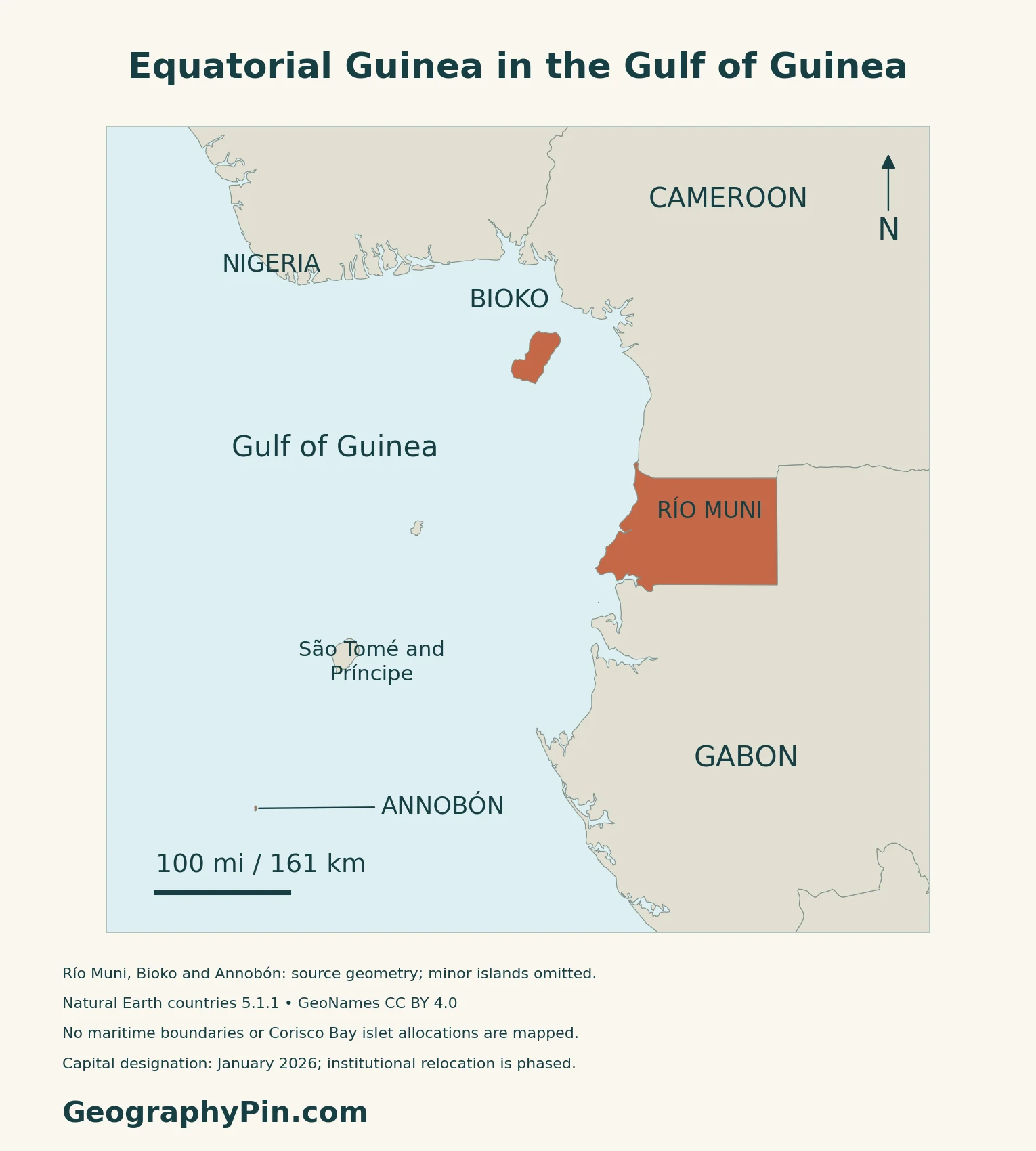
Equatorial Guinea is a country in Central Africa, on the Gulf of Guinea. Its mainland, Río Muni, borders Cameroon to the north and Gabon to the east and south. Bioko and Annobón are separate island territories; Corisco and the Elobey islands lie near the mainland coast.
Ciudad de la Paz and the move from Malabo
Ciudad de la Paz, in mainland Djibloho province, is the national capital. Decree-Law 1/2026 of 2 January declared it the capital, and Law 4/2026 of 10 April revalidated that decision. Malabo, the former capital, is on Bioko.
The legal designation and the relocation of government offices are different steps. The decree allowed a year from its entry into force for institutions to arrange their transfer. The government’s July 2026 relocation plan described a phased process, with some departments temporarily continuing to operate from Malabo.
2. Three Landscapes to Read on the Map
Mainland and island contrasts
| Component | Landscape | How to read its position |
|---|---|---|
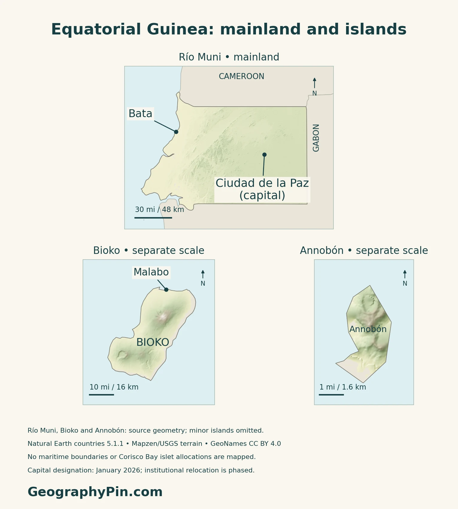
| Río Muni | Coastal lowlands and an inland plateau cut by rivers | The mainland territory between Cameroon and Gabon |
| Bioko | Steep volcanic slopes and high summits | An island offshore from Cameroon, not attached to Río Muni |
| Annobón | A small, mountainous volcanic island | Far southwest of the other main components |
The national biodiversity report distinguishes the mainland’s older continental rocks from the volcanic origins of Bioko and Annobón. These three large components are not an exhaustive list of every island: Corisco and the Elobey islands also belong in a fuller account of the country.
Bioko is built from volcanic mountains
The Smithsonian Global Volcanism Program describes Bioko as formed by three basaltic shield volcanoes. Pico Basilé is the largest and highest of the three. The island sits on the continental shelf along the Cameroon volcanic line, linking its geological setting with Mount Cameroon across the water.
Annobón is remote and internally mountainous
Equatorial Guinea’s 2026 Tentative List submission describes Annobón as a volcanic island with steep relief, crater features and the lake known as A Pot. It includes forest, coastal cliffs and marine habitats. This is a separate island landscape, not a southern extension of the Río Muni coast.
Annobón’s natural reserve was submitted to UNESCO’s Tentative List in April 2026. That submission is not inscription on the World Heritage List. The map’s separate island detail makes its shape visible without pretending it is at the same scale as the mainland.
3. Rain, Forests and River Landscapes
A wet country does not have one rainfall pattern
The country’s first national biodiversity report describes heavy but variable rainfall. Southern Bioko is much wetter than the island’s northern coast, while Annobón has its own seasonal pattern. Steep slopes and very heavy rainfall also limit the land that can readily be cultivated on Bioko.
These contrasts come from a historical environmental assessment, not current-year observations.
Río Muni is both a regional name and an estuary name
Río Muni commonly names the whole mainland component of Equatorial Guinea. The Muni estuary is a specific feature near its southern coast. The country’s river names also include Río Benito, known locally as Mbini, and the northern border river Ntem, also called Río Campo. These are not interchangeable names for one river.
Monte Alén connects uplands with forest habitats
The state’s 2026 UNESCO Tentative List description places Monte Alén National Park in the mainland interior, with steep terrain, old crystalline rocks and humid equatorial forest. It describes the Wele, or Benito, river basin and transitions toward lower coastal and estuarine landscapes.
Monte Alén helps explain why mainland Río Muni is not simply a flat strip beside the sea. Forested uplands and river valleys form part of its interior.
4. Land, Food and the Petroleum Economy
Food production and imports coexist
FAO’s July 2026 country brief identifies cassava, sweet potatoes, plantains, groundnuts and bananas among staple crops, with cocoa among the cash crops. It also describes heavy reliance on commercial food imports. A tropical climate and productive farming areas therefore do not imply that the country supplies all its own food.
Oil income is not the same as a diversified economy
The World Bank’s November 2026 economic update describes declining hydrocarbon production and a need for more sources of employment. It identifies agribusiness, tourism, fisheries and other activities as potential areas for diversification. These are development opportunities discussed in a dated assessment, not evidence that the transition has already been achieved.
Forests have value beyond cleared land and timber
The World Bank’s 2025 wealth assessment considers forests as assets that retain carbon and sediment as well as supporting biodiversity. It links conservation with land-use planning, sustainable agriculture and local processing. This perspective distinguishes annual economic output from the condition of the natural resources on which future activity depends.
5. Dated Facts, Languages and Institutions
| Item | Reference | Date or scope |
|---|---|---|
| Capital | Ciudad de la Paz | Declared by Decree-Law 1/2026; institutional relocation phased |
| Population | About 1.727 million | INEGE national estimate for 2025, reported in September 2026 |
| Surface area | About 10,831 sq mi (28,052 km²) | UN reference, 2023; surface-area convention |
| Official languages | Spanish, French and Portuguese | Official status does not describe every spoken language |
| Currency | Central African CFA franc (XAF) | BEAC-issued currency |
| Government | Presidential republic | Fundamental Law and current official country information |
An estimate, not a new census count
The 2026 yearbook presentation reported an INEGE estimate of 1,727,151 people for 2025. The preceding statistical edition explains that its population projections use the 2015 census as their base. That census counted 1,225,377 people, including nationals and foreign residents, across the mainland and island regions.
On 16 November 2026, INEGE was still validating questionnaires and other preparatory documents for the fifth population and housing census. The table therefore does not present the estimate as a new enumeration result.
Languages and territorial administration
Article 4 of the Fundamental Law names Spanish and French and allows other languages designated by law; current official country information also lists Portuguese. The same constitutional article recognizes Indigenous languages as part of national culture.
INEGE’s 2025 statistical edition describes eight provinces across the mainland and island regions. Provinces, districts and municipalities are administrative units, not separate countries. The state is a republic with executive authority vested in the presidency.
What Did We Learn Today?
Equatorial Guinea combines mainland Río Muni with distinct island landscapes. Bioko’s volcanic mountains, Annobón’s remote setting and Río Muni’s forested interior should be read separately. Ciudad de la Paz is the newly declared capital, but designation and institutional relocation are different processes.
Sources & Data Notes
Capital designation and actual institutional relocation are treated separately. National population figures retain their reference year and statistical label. Older environmental reports support stable landform and rainfall contrasts, not current population, forest-cover percentages or weather. UNESCO Tentative List entries are state submissions, not World Heritage inscriptions; their older capital wording is not used here. The Smithsonian volcanic description is not a present hazard forecast. The 2025 and 2026 World Bank assessments have different reference periods. Separate map details use their own scales, and omitted small islands are identified in the map method.
- Government Press Office: full Decree-Law 1/2026, 2 January, declaring Ciudad de la Paz the capital
- Government Press Office: Law 4/2026 of 10 April revalidating the capital decree
- Government Press Office, 1 July 2026: phased institutional relocation
- Government Press Office, 25 September 2026: INEGE national population estimate for 2025
- INEGE, 16 November 2026: preparatory work for the fifth population and housing census
- INEGE, Guinea Ecuatorial en Cifras 2025: census basis and territorial organization
- UNData: surface area, 2023 reference; XAF currency code
- Fundamental Law: Articles 1, 3, 4 and 33 on institutions, territory and languages
- Equatorial Guinea Embassy in Spain: official languages and geographic location
- BEAC: Central African CFA franc
- Equatorial Guinea: fourth national biodiversity report, physical regions
- Smithsonian Global Volcanism Program: Pico Basilé and Bioko geology
- Equatorial Guinea UNESCO Tentative List submission, April 2026: Annobón
- Equatorial Guinea: first national biodiversity report, 1998, rainfall and rivers
- UK PCGN, January 2026: geographical names, mainland and islands
- Equatorial Guinea UNESCO Tentative List submission, April 2026: Monte Alén
- FAO GIEWS, July 2026: food production and imports
- World Bank, November 2026: employment and diversification
- World Bank, 2025: national wealth and forest ecosystem services
Map method: Original GeographyPin maps use public-domain Natural Earth countries version 5.1.1. All three source components, Río Muni, Bioko and Annobón, are retained. Smaller islands, including Corisco, the Elobeys and the Corisco Bay case islets, are omitted by this generalized source; the maps do not resolve their legal status or draw maritime boundaries. Annobón’s angular outline is not a detailed shoreline survey. GeoNames city coordinates are credited under CC BY 4.0. Ciudad de la Paz is labeled capital under the January 2026 decree; institutional relocation remains phased. Real Mapzen Terrain Tiles provide relief, with Mapzen/USGS and upstream credits. Coastal raster artifacts are transparent, not replaced with invented heights. The three physical panels have separate WGS84 scales and differently scaled relief shading, not a shared elevation legend. The cover uses the Commons/OpenClipArt flag rendition, released under CC0, with a separate complete flag for editorial identification.