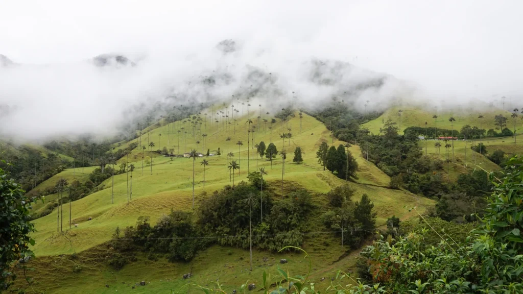
A map of Colombia connects landscapes that are easy to imagine separately: Andean cities, Caribbean islands, Pacific shores and broad eastern lowlands. The important question is how they fit together. Mountain ranges divide valleys, rivers lead toward different basins, and the country extends beyond the outline of its South American mainland.
Colombia is a country in northwestern South America with Caribbean and Pacific coasts. Its Andes divide into three major cordilleras, while the eastern lowlands connect to the Orinoco and Amazon systems. Bogotá is the capital. The country is spelled Colombia, with an “o,” rather than Columbia, which names other places and institutions.
How to use this article: Read what the national figures measure, compare the three Andean ranges, or distinguish natural regions from river basins.
1. Where is Colombia?
Colombia occupies the northwestern corner of South America. Its five land neighbors are Panama, Venezuela, Brazil, Peru and Ecuador. The Caribbean Sea lies along the northern coast, while the Pacific Ocean borders the west. The Colombian Ministry of Foreign Affairs: territory and neighboring countries distinguishes the country’s territorial extent from its much larger combined land-and-maritime setting.
The spelling is Colombia in both the country’s Spanish name and its English name. “Columbia” is not an alternative English spelling of this republic. When checking a map or address, the second vowel matters: an otherwise familiar-looking name can refer to a different location altogether.
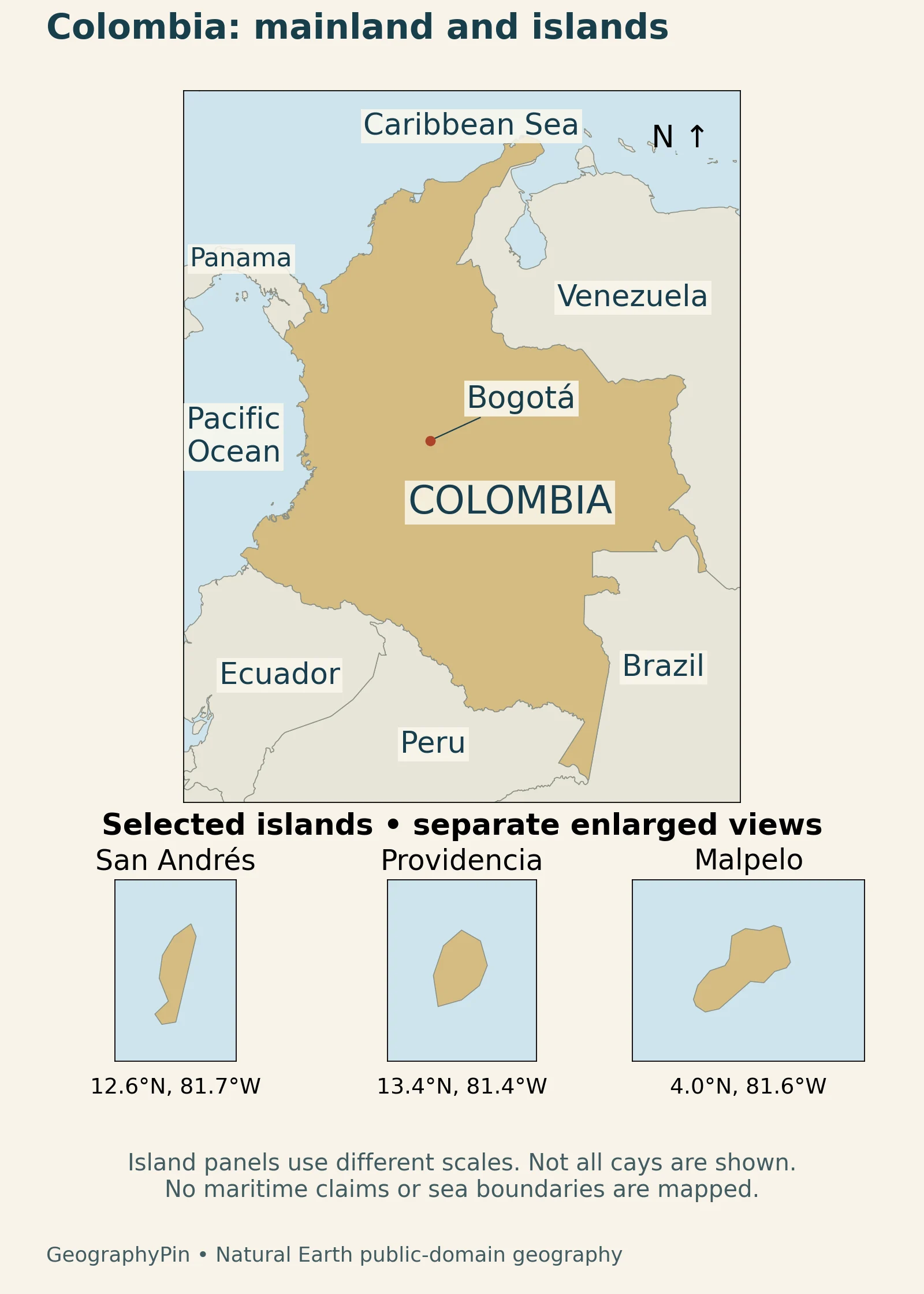
San Andrés and Providencia are far from the mainland coast. Their enlarged panels make these small islands visible without suggesting that they are adjacent to the mainland.
2. Country facts and the meaning of their dates
A country profile combines relatively stable facts with statistics that change. For population, the issuing agency, reference year and type of estimate matter. For area, territorial extent should not be confused with maritime jurisdiction or a measurement taken from a simplified illustration.
| Topic | Fact | Scope |
|---|---|---|
| Capital | Bogotá | National capital |
| Territorial area | About 440,831 sq mi (1,141,748 km²) | Foreign Ministry figure; excludes the separate maritime-area total |
| Population | About 53.4 million (53,399,171) | DANE projection for 2026, July 2025 series |
| Currency | Colombian peso (COP) | National currency |
| Land neighbors | Panama, Venezuela, Brazil, Peru and Ecuador | Five neighboring countries |
The population value is taken from the DANE: national population series, 2018–2070, linked through the DANE: national population projections, July 2025 update. It is a projection based on the 2018 census and later demographic updates, not a new head count conducted in 2026. Colombia Travel: national currency identifies the peso and its COP abbreviation.
A projection is not a live population counter
The series was updated in July 2025, while the figure above refers to 2026. Those are different dates serving different purposes. A household survey, a census and a population projection can produce different totals because they are different statistical operations. Keeping one clearly identified national series is more useful than mixing figures that happen to be available on the same day.
3. The Andes divide into three major ranges
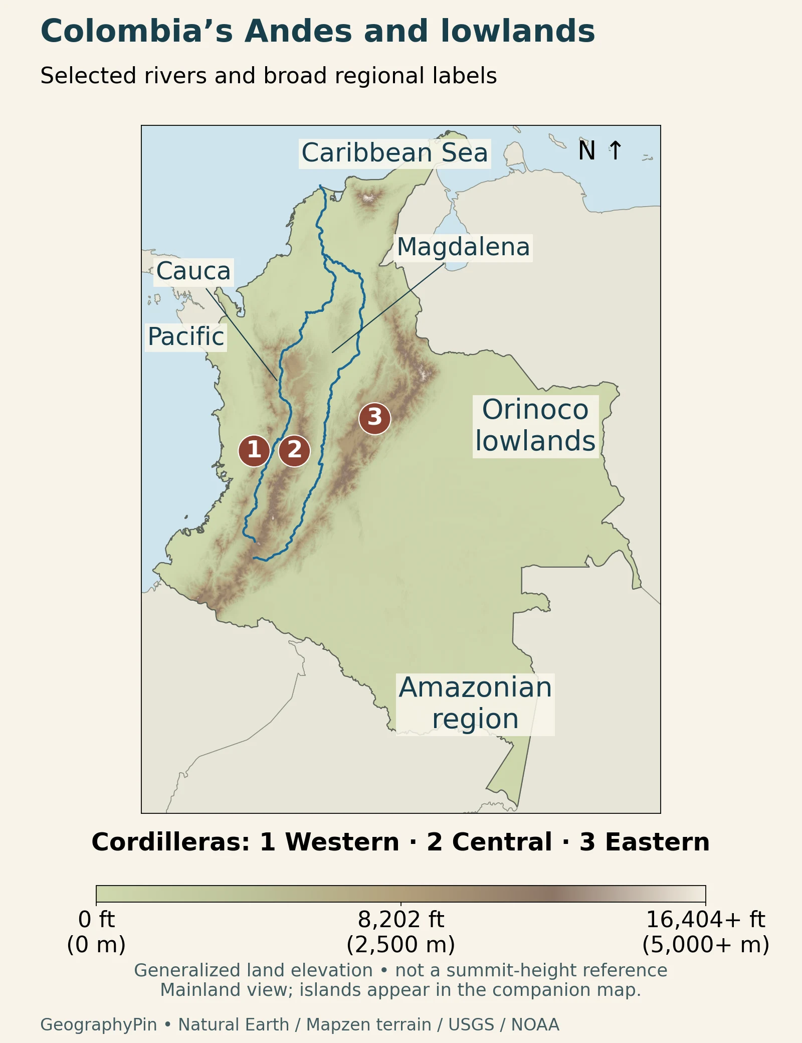
The Colombian Geological Survey: physiographic and geological setting identifies three Andean cordilleras. The Cauca valley separates the Western and Central ranges; the Magdalena valley separates the Central and Eastern ranges.
Read the valleys as well as the ridges
Start by locating the two named rivers on the relief image, then look at the higher ground on either side. A mountain label alone cannot show how ranges separate routes, valleys and settlements. The intervening lower ground is part of the structure of the mountain region, not a gap in the geography.
Other highlands include the separate Sierra Nevada de Santa Marta near the Caribbean and Serranía de Baudó toward the Pacific.
The elevation colors are a generalized view. They do not supply a surveyed summit height, a pass elevation or a safe route. Broad slopes and valleys are meaningful at country scale; small features require more detailed mapping.
4. Two coasts, offshore islands and different drainage systems
Gorgona and Malpelo are Pacific islands. San Andrés and Providencia are Caribbean islands. The locator’s enlarged panels show San Andrés, Providencia and Malpelo.
Natural regions are not the same as river basins
The familiar six-region framework includes the Andean, Caribbean, Pacific, Orinoquía, Amazonian and Insular regions. Hydrographic planning uses a different classification. The Ministry of Environment: five hydrographic planning areas lists five major areas: Caribbean, Magdalena–Cauca, Orinoco, Amazon and Pacific. The two lists are not competing counts of the same thing.
A natural-region description combines landscape characteristics. A drainage classification follows how water is organized into river systems. A department, meanwhile, is an administrative unit. Knowing which kind of boundary a map represents prevents a river-basin label from being mistaken for a political division.
A river line also leaves out much of a floodplain. In May 2006, NASA Earth Observatory: Magdalena flooding in May 2006 showed expanded wetlands around parts of the Magdalena compared with imagery from March. That dated observation illustrates why water can occupy a wider landscape than the thin line on a national map. It is not a description of current flooding.
5. The eastern lowlands are not one uniform landscape
East of the Andes, the Orinoquía is associated with plains, savannas and river corridors. The Colombian Environmental Information System: Orinoquía describes extensive grassland settings interrupted by gallery forests. Rivers such as the Meta and Guaviare help explain the region’s connections to the wider Orinoco system.
Gallery forest means woodland associated with a river corridor. It is not the same pattern as continuous forest across an entire region. A broad “lowland” label can therefore conceal important differences in vegetation, drainage and seasonal conditions.
Farther south and southeast, Amazonian Colombia includes forested landscapes but is not perfectly flat. The wider Amazon River basin is a drainage system, not an identical outline of rainforest. The National Parks of Colombia: Serranía de Chiribiquete describes Chiribiquete’s table-like rocky formations, forests, floodable savannas and freshwater ecosystems. Its geography cannot be reduced to a blank green patch on a map.
Chiribiquete also makes an important human-geography point: these landscapes include Indigenous territories and communities, including peoples in voluntary isolation. Low population density does not mean an empty or ownerless landscape. Describing these places does not make them open-access destinations.
6. Bogotá, elevation and climate
Bogotá lies in the Eastern Cordillera. The Bogotá city government: location of the capital describes a capital framed by its eastern hills, which provide a clear local orientation. This is a highland setting, unlike Colombia’s low-lying coastal or eastern landscapes.
The FAO Colombia: altitude, climate and agricultural vulnerability explains the general relationship between elevation and temperature: higher locations tend to be cooler than lower ones. Rainfall varies between regions and through the year, and climate variability can affect agriculture. Being in the tropics does not give every Colombian place the same temperature or rainfall pattern.
It is useful to separate three questions when reading a place description: how high is it, which side of a mountain system is it on, and what seasonal climate does it have? Latitude alone cannot answer all three. Likewise, a photograph of a green Andean valley does not describe the conditions along every coast or across every eastern plain.
The map’s capital marker identifies a place, not the full boundary of Bogotá’s administrative district or its built-up area. Comparing city populations requires those boundaries to be specified. The national population in the table should not be used as a shortcut for understanding how people are distributed among individual cities.
7. People, production and connections between regions
Colombia is a decentralized unitary republic, rather than a federation. Its Colombian Constitution: Articles 1, 10 and 322 makes Spanish the national official language and recognizes ethnic groups’ languages and dialects as official within their territories. Bogotá is organized as a capital district. These distinctions describe institutions and language rights, not a claim that the country has one uniform culture.
Physical geography helps explain how production takes place, but it does not determine every economic outcome. The DANE: 2025 national accounts, February 2026 release reports activities ranging from agriculture and manufacturing to trade, transport, finance and public services. Coffee and minerals are only part of this broader mix.
The UNESCO: Coffee Cultural Landscape of Colombia offers a more specific geographic example: steep slopes, small agricultural plots and hilltop settlements form part of a recognized landscape in the western and central Andean foothills. That designation concerns a defined cultural landscape, not every coffee-growing district in Colombia. It shows how land use and settlement can be read together rather than treating farms as isolated dots.
Caribbean and Pacific ports connect different sides of the country
The Superintendence of Transport: 2025 port traffic report records traffic through both coastal regions. Cartagena is a Caribbean example, while Buenaventura is on the Pacific. The two names identify different gateways; they should not be treated as neighboring ports on one coastline.
Port statistics also require a scale check. A whole port zone can contain several terminals and operators, so the traffic handled by one company is not necessarily the total for the named city. Tonnes measure cargo mass, while container units measure a different aspect of traffic. Neither is automatically the monetary value of exports.
The ports connect coastal locations with production and consumers farther inland. A cargo statistic describes those flows; it does not measure the population or economic output of the entire city around the terminal.
What Did We Learn Today?
Natural regions, river basins and administrative divisions answer different questions. Reading those distinctions alongside dated population figures produces a clearer country profile than treating every map label or statistic as interchangeable.
Sources & Data Notes
Population is the 2026 projection from DANE’s July 2025 series, not a census count. The maps use generalized geography and historical terrain data; island panels have separate scales.
- Colombian Ministry of Foreign Affairs: territory and neighboring countries
- DANE: national population projections, July 2025 update
- DANE: national population series, 2018–2070
- Colombian Geological Survey: physiographic and geological setting
- Ministry of Environment: five hydrographic planning areas
- Colombian Environmental Information System: Orinoquía
- National Parks of Colombia: Serranía de Chiribiquete
- Bogotá city government: location of the capital
- FAO Colombia: altitude, climate and agricultural vulnerability
- UNESCO: Coffee Cultural Landscape of Colombia
- NASA Earth Observatory: Magdalena flooding in May 2006
- Colombian Constitution: Articles 1, 10 and 322
- DANE: 2025 national accounts, February 2026 release
- Superintendence of Transport: 2025 port traffic report
- Colombia Travel: national currency
Map sources and method: Original GeographyPin maps use Natural Earth public-domain coastlines, country geometry, populated places and river data. The island panels enlarge actual generalized polygons separately; no maritime boundaries are shown. The relief uses Mapzen terrain tiles, decoded from Terrarium values at zoom 7, with nominal cells of about 0.75 mi (1.2 km) near the equator. Display interpolation does not increase measurement resolution. Terrain credits include USGS SRTM/GMTED and NOAA ETOPO source data, as documented in the terrain attribution notes. Colors saturate above 16,404 ft (5,000 m); they are not surveyed summit heights. Ridge numbers are broad reference locations checked against the Geological Survey’s physiographic map, not measured range boundaries.
Featured photograph: Cocora Valley in January 2020. Photo by Bernard Gagnon / Wikimedia Commons, CC BY-SA 4.0; cropped to a wide frame and resized. This photographic derivative retains that license.