A coastal port, an upland royal city and a settlement beside the Logone River reveal different sides of Cameroon. Understanding the country means connecting its landscapes with particular communities, rather than treating its official languages or national border as a complete description of its culture.
Cameroon is a Central African country on the Gulf of Guinea, extending north toward Lake Chad. Its coast, western highlands, southern forests and northern savannas support distinct regional settings. French and English are official languages, but neither that bilingual status nor a single cultural label captures the country’s many communities.
How to use this article: Compare the landscape contrasts, separate official languages from everyday language, or locate specific cultural traditions.
1. Where is Cameroon?
Cameroon occupies the bend of Africa’s Atlantic coast, between Nigeria and the Central African Republic. It also borders Chad, Equatorial Guinea, Gabon and the Republic of the Congo. The latter is a different country from the Democratic Republic of the Congo; Cameroon does not border the DRC.
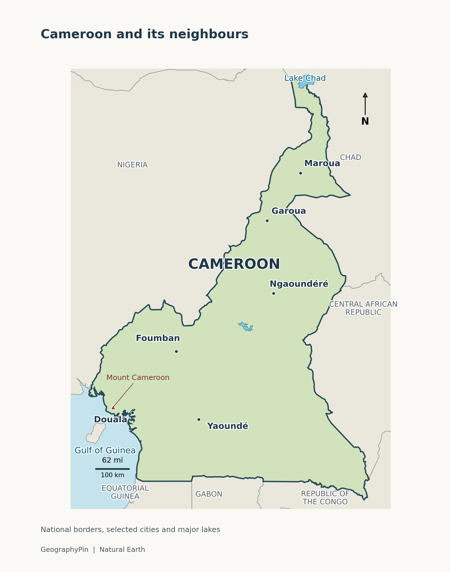
The UN places Cameroon in its Middle Africa statistical subregion. Geographic descriptions also emphasize its position between western and central Africa. These are compatible observations, not competing claims about where the border lies. Our Central Africa map explains the regional convention.
Start at Douala on the coast, then locate Yaoundé inland and the country’s narrow northern extension. That shape is important: a description based only on the humid coast misses much of Cameroon. Equally, a photograph from the drier north cannot represent the whole country.
2. Country facts and the dates behind them
| Item | Value and scope |
|---|---|
| Capital | Yaoundé |
| Population | About 29.9 million; UN 2025 projected estimate, medium-fertility variant |
| Surface area | About 183,650 square miles (475,650 square kilometers); UNData’s 2023 reference |
| Official languages | English and French, with equal constitutional status |
| Currency | Central African CFA franc, issued by BEAC; currency code XAF |
| Administrative regions | 10; distinct from physical regions or language communities |
The population and area figures come from UNData’s Cameroon profile. A projection is not a census count. Also, the year at the top of a statistical column does not necessarily apply to every entry: the profile’s footnotes identify older reference years for several measures.
Area totals can differ when publications use different geographic definitions or revisions. This table consistently uses the stated surface-area figure, not a mixture of land area and total area. Rounded square miles are a conversion, not an independent measurement.
For local comparisons, the National Institute of Statistics’ regional yearbooks provide another level of detail. Their commune-level statistics answer different questions from a national total. A city municipality, its built-up area and its surrounding metropolitan region should not be treated as interchangeable population units.
3. From the coast to the northern savannas
Read the country as a sequence of landscapes
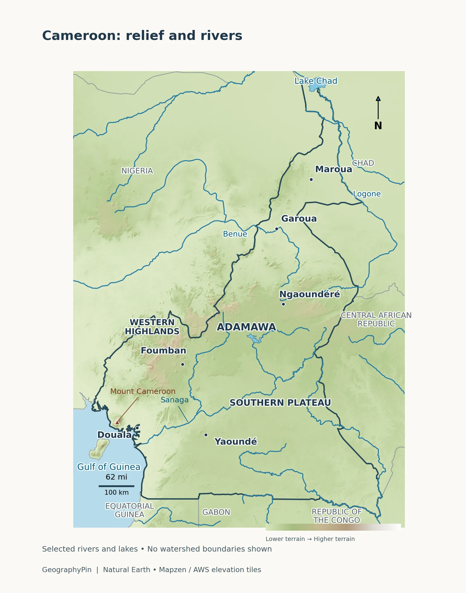
The coast and southern plateau differ from both the western uplands and the northern plains. The British Geological Survey’s physical overview describes this basic structure; the FAO distinguishes five agroecological zones, a classification designed to explain farming environments rather than cultural boundaries.
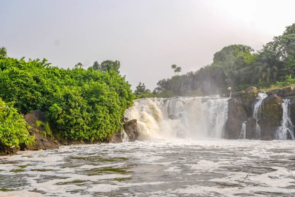
At Douala, the Wouri estuary connects the low-lying coast to the sea. Farther south, the Lobé Falls near Kribi provide a different coastal view: river water descending over rock beside dense vegetation. Neither scene should be mistaken for the upland setting around Foumban.
Mount Cameroon rises near the southwestern coast. The Smithsonian’s Global Volcanism Program lists this volcano at 13,435 feet (4,095 meters). Its relief also shows why latitude alone cannot explain local conditions: a high mountain and its nearby coastal lowlands are not the same environment.
Farther inland, the Adamawa Plateau forms a broad upland zone between southern Cameroon and the northern lowlands. On the map, Ngaoundéré provides a reference point for this central highland setting; Garoua lies farther north in the Benue region. Elevation shading represents terrain, not the distribution of people or languages.
Rainfall changes with latitude and elevation
FAO’s agroecological outline distinguishes western highlands, high savanna, a northern Sudano-Sahelian zone, and two southern forest-zone rainfall patterns. In this terminology, “monomodal” means one principal rainy season; “bimodal” means two main seasonal rainfall peaks. It does not mean rain falls continuously throughout either period.
These categories help explain why a single national “rainy season” is an inadequate description. The northern lowlands are generally drier than the southern coast, while altitude modifies conditions in the uplands. They also describe broad patterns: a regional climate category is not a forecast for a particular town or travel date.
4. Where Cameroon’s rivers flow
Cameroon’s rivers do not all reach the sea by the same route. The Sanaga, Wouri, Nyong and Ntem drain toward the Gulf of Guinea. The Benue, also written Bénoué, flows into Nigeria and joins the Niger. In the northeast, the Logone belongs to the Lake Chad system; southeastern rivers including the Dja and Kadéï feed the Congo system.
That makes Cameroon a useful example of the difference between a national border and a watershed. A watershed is the land draining toward a particular outlet. Rain falling inside one country can enter a river system whose main channel or final outlet lies elsewhere.
The Niger River route map follows the larger system that receives the Benue. It does not mean the Niger’s main channel crosses Cameroon. Likewise, describing southeastern Cameroon as part of the Congo drainage basin does not make it part of either country named Congo.
Keep river lines, land-cover colors and country boundaries separate when reading the maps. A forest can cross a drainage divide, and a river basin can contain more than one vegetation type. None of those natural divisions defines an exclusive cultural territory.
5. Languages, cities and historical geography
Official bilingualism is not a two-language society
Cameroon’s constitution gives English and French equal official status, as summarized by the Presidency’s account of the state. That describes a legal arrangement. It does not establish that every resident speaks both languages, or that Cameroon has only two languages.
The English-language educational tradition is particularly associated with the Northwest and Southwest regions; the French-language system predominates across the other eight. Cameroon also has many Indigenous languages. Alberta’s education-system reference identifies examples including Duala, Ewondo and Fulfulde. These are not alternative names for English or French, and a person’s language use cannot safely be inferred from a dot on a national map.
Yaoundé is the capital, while Douala has a major port and commercial role. They therefore provide different reference points for understanding settlement. A capital-city entry, such as Cameroon’s in our world capitals directory, identifies an administrative function, not the location of all economic or cultural activity.
Why English and French both matter
German colonial rule was followed by British and French administration. The French-administered territory became independent in 1960. The subsequent British Cameroons plebiscites had different outcomes in its northern and southern parts, a distinction that is easily lost in a one-sentence national history.
UN General Assembly Resolution 1608 (XV) specified Northern Cameroons joining Nigeria on June 1, 1961, and Southern Cameroons joining the Republic of Cameroun on October 1, 1961. Those historical names refer to former administered territories, not simply today’s northern and southern halves of Cameroon.
The legacy helps explain official-language institutions, but does not replace the histories of the communities living within them. “Anglophone,” “Francophone,” a regional name and a community identity describe different things; they should not be used as if each were an exact synonym for the others.
6. Cultural traditions belong to particular communities
Four examples, not one national stereotype
Culture becomes more informative when a practice is connected to its community and setting. UNESCO’s living-heritage records for Cameroon offer named examples, not a complete inventory of how all Cameroonians live.
- Ngondo and the Sawa: UNESCO’s account connects these traditions with water oracles and gatherings on the Wouri River. Its 2024 multimedia description also records performances and community events. Here, the river is part of a lived cultural setting as well as a physical waterway.
- Nguon and the Bamoun community: Associated with Foumban, these are rituals involving the Mfon, or monarch, and the community. UNESCO describes consultation and dialogue within the practice. It is more accurate to identify Nguon with the Bamoun community than to call it a ceremony shared by the whole country.
- Guruna and the Massa: The UNESCO record locates this pastoral and cultural practice on both sides of the Logone in Cameroon and Chad. A national boundary therefore does not contain the whole community or its cultural connections.
- Mvet Oyeng and the Ekang community: UNESCO describes epic storytelling with music and dance and lists the heritage jointly for Cameroon, Gabon and Congo. The cross-border listing is another reminder that a country profile cannot turn cultural relationships into sealed national compartments.
These examples should not be assigned to every resident of their wider region. Living in the same city, speaking the same official language or sharing an environmental setting does not imply participation in the same tradition. Equally, selecting a few documented practices does not rank them above traditions absent from an international list.
The Dja Faunal Reserve is part of the Congo Basin rainforest setting and is almost encircled by the Dja River. Southern forest landscapes are also inhabited social spaces, not empty scenery. UNESCO’s September 2026 account of work near Dja and Lobéké discusses Indigenous Baka communities and neighboring populations alongside access to civil-registration documents. Conservation and contemporary community life belong in the same picture.
7. How geography shapes the economy
Cameroon’s economic geography links farms, forests, extraction and urban services to transport routes. The World Bank’s country overview identifies cocoa, coffee, cotton, maize and cassava among its agricultural products, alongside timber, oil and gas. These are examples of economic activities, not a claim that each is equally important in every region.
Douala and Kribi are major maritime gateways. The U.S. International Trade Administration’s distribution overview places Douala on the Wouri estuary and describes connections serving landlocked Chad and the Central African Republic. This gives the coast a role beyond Cameroon’s own domestic market.
The physical map helps explain the connection: cargo entering through a coastal gateway must move inland rather than remaining at the shoreline. But terrain alone does not determine economic outcomes. Transport capacity, investment and access to services also matter. A country’s resources should not be treated as proof that every household benefits equally from them.
Frequently Asked Questions
Are Cameroon and Cameroun different countries?
No. Cameroon is the English spelling and Cameroun the French spelling of the same country. Both may appear in documents and place-name databases.
What Did We Learn Today?
Cameroon is easier to understand when several geographic layers are kept separate: its national territory, terrain, river basins, language institutions and community connections do not share identical boundaries. Douala, Foumban and the Logone setting illustrate different relationships between place and culture, while dated national statistics provide context without substituting for local detail.
Sources & Data Notes
The population is a UN medium-variant projection for 2025, not a new census. Surface area follows UNData’s 2023 reference and is rounded when converted to square miles. Cultural examples refer to named communities; they are not mapped as exclusive ethnic territories. Physical descriptions use broad regional patterns rather than a forecast or a travel-safety assessment.
- UNData: Cameroon profile and reference-year footnotes.
- British Geological Survey: Hydrogeology of Cameroon, physical setting and drainage; FAO: agroecological zones.
- Smithsonian Global Volcanism Program: Mount Cameroon.
- Presidency of Cameroon: official-language status; Alberta IQAS: educational language systems.
- United Nations: Resolution 1608 (XV), 1961.
- UNESCO: community-specific living heritage; Ngondo multimedia record; Nguon record.
- UNESCO World Heritage Centre: Dja Faunal Reserve; community work around Dja and Lobéké, September 2026.
- World Bank: Cameroon overview; International Trade Administration: distribution networks.
- INS: Littoral regional statistical yearbook, 2024 edition.
Map methods: generalized Natural Earth boundaries, lakes and selected river lines are combined with elevation from Mapzen Terrain Tiles (USGS SRTM/GMTED2010; NOAA ETOPO1). Relief colors and shading emphasize terrain; they are not land-cover classes. Scale bars are approximate across the map. These are orientation maps, not navigation charts.
Featured photograph: Lobé Falls, by Evr1rd via Wikimedia Commons, CC BY-SA 4.0. Resized and converted for web display; the adapted image is shared under the same license.
