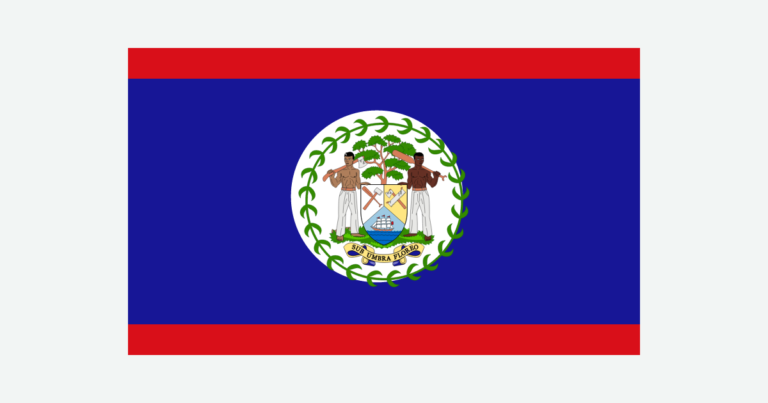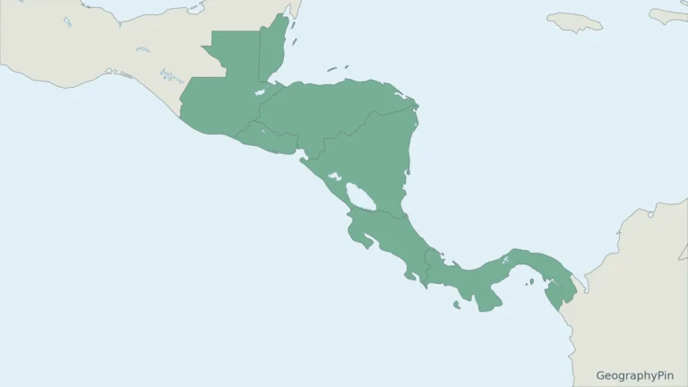
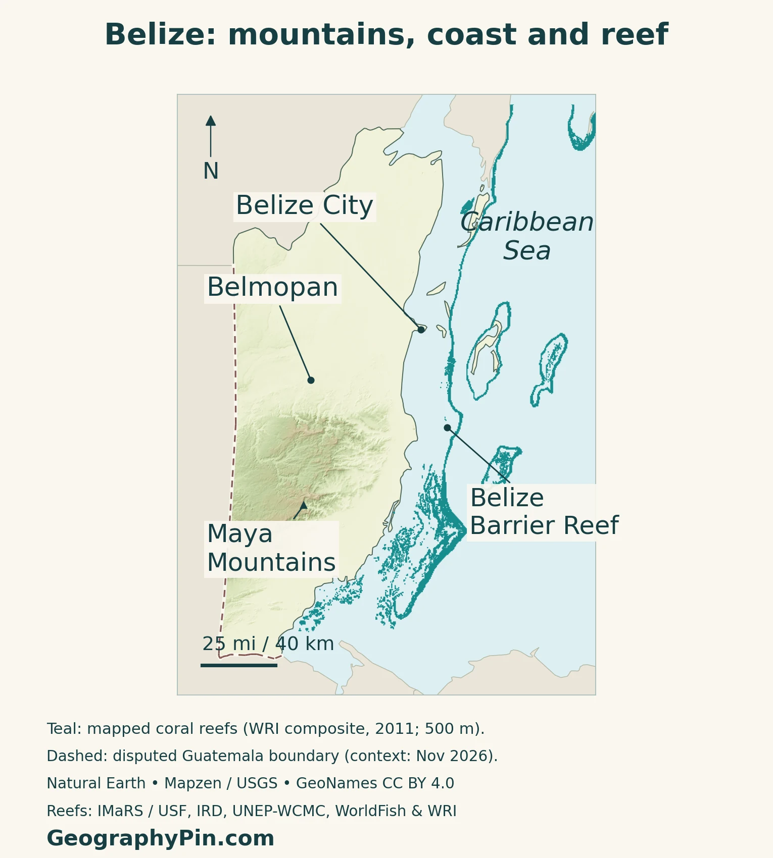
Belize faces the Caribbean Sea from the Central American mainland. Its geography joins limestone lowlands, the Maya Mountains, river valleys and an offshore reef landscape. The inland capital, Belmopan, and coastal Belize City show why a country’s political center and its best-known city need not occupy the same place.
Belize is an independent Central American country on the Caribbean coast, bordered on land by Mexico and Guatemala. Belmopan is its capital. Northern lowlands contrast with the Maya Mountains farther south, while cayes, coastal lagoons and the Belize Barrier Reef extend its geography offshore. Its mainland location and Caribbean connections are complementary, not competing identities.
How to use this article: Locate Belize in the region, compare its main landscapes, understand the reef system, or check dated country facts.
1. Where Belize Is and How to Read the Map
Central American mainland, Caribbean coast
Mexico lies north of Belize, Guatemala west and south, and the Caribbean Sea east. Unlike several Central American neighbors, Belize has no Pacific coastline. The country includes a substantial mainland and offshore cayes, rather than being a single Caribbean island.
Central America describes its position on the mainland bridge within North America. Caribbean describes its coastal setting and wider regional connections. Belize joined the Caribbean Community, CARICOM, in 1974 and the Central American Integration System, SICA, in 2000. Those memberships make the overlap especially clear: one country can belong to more than one regional network.
For the surrounding countries, use the Central America countries map. The North American countries and capitals list places Belize in the broader continental framework.
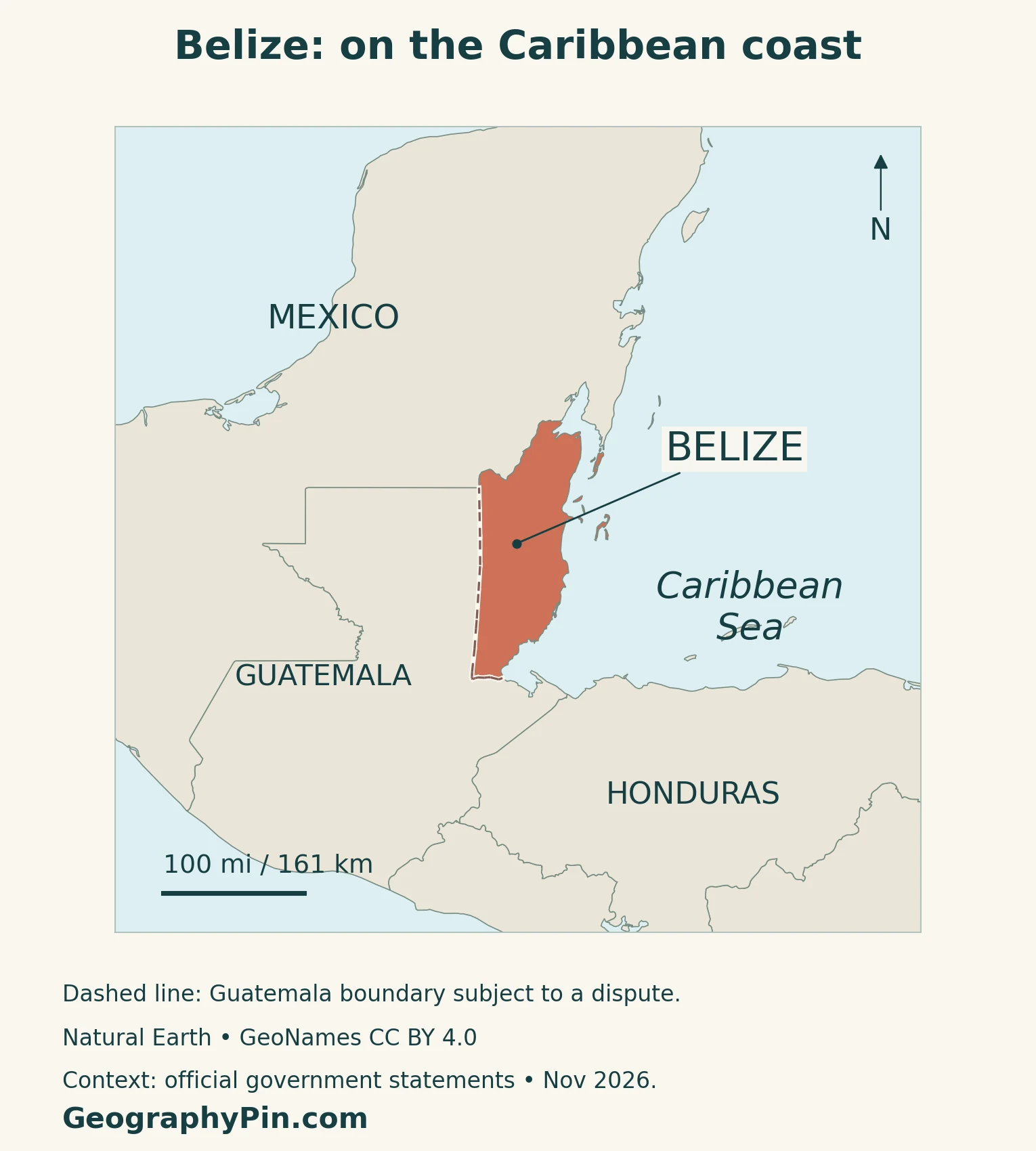
Read the map in three steps. Find the mainland coast first, distinguish inland Belmopan from Belize City next, then look east toward the reef and cayes. The offshore features are part of the national landscape, but a reef outline is not a maritime boundary.
2. Lowlands, Maya Mountains and River Country
A landscape more varied than a coastal plain
Northern Belize lies largely on the limestone Yucatán Platform, with lowlands interrupted by hills, wetlands and valleys. Limestone can conceal underground drainage beneath a relatively gentle surface.
The Maya Mountains form a more rugged interior in the south-central part of the country. Their rock includes old granite and sedimentary formations, with limestone around the uplands. This is not simply another chain of young Central American volcanic cones.
In limestone areas, water dissolves rock along fractures, producing karst: caves, sinkholes and underground streams. Mountain Pine Ridge is one of the recognizable upland areas, not the name for all of Belize’s mountains.
| Setting | What to look for | Connection to people and water |
|---|---|---|
| Northern lowlands | Limestone plains, low hills and wetlands | Farming, towns and river catchments share the lowland landscape |
| Maya Mountains and surrounding uplands | Rugged terrain with varied rocks and karst around the massif | Forested headwaters and valleys connect inland areas with lower ground |
| Coastal plain and estuaries | Low land, lagoons and river mouths | Settlement and infrastructure meet flooding and coastal-water conditions |
| Reef, cayes and offshore atolls | Shallow marine habitats interspersed with deeper water | Fisheries, tourism and conservation depend on connected ecosystems |
The regions in this comparison are explanatory groupings, not administrative districts or precisely surveyed geological zones. Their edges are transitional. A district can include several kinds of terrain, and a single river can connect upland, agricultural and coastal environments.
3. The Barrier Reef Is Not the Whole Coast
Reef, lagoon, cayes and atolls are different features
The Belize Barrier Reef runs offshore along the Caribbean side of the country. Between mainland and reef are shallow coastal waters, with mangroves, seagrass and lagoonal habitats. Farther offshore lie Turneffe, Lighthouse Reef and Glover’s Reef, the three atolls identified in UNESCO’s account of the reef complex.
A caye is a low island; an atoll is a reef formation surrounding a lagoon; the barrier reef is an elongated reef system separated from shore by intervening water. Treating these names as synonyms makes the map harder to understand.
UNESCO’s Belize Barrier Reef Reserve System is a serial World Heritage property comprising seven protected areas. It is not a designation covering every part of the country’s marine waters, nor is each caye a separate World Heritage site. The famous Blue Hole is one component of a much larger marine landscape.
Mangroves make the shore more than a line
On the mainland and cayes, mangrove forests occupy places where land and tidal water meet. Research on mangrove restoration in Belize describes coastal development, dredging, wastewater and sediment from inland land clearance as pressures on these habitats.
That helps explain why reef conservation cannot be reduced to drawing a line around coral offshore. What happens at a river mouth, on a waterfront building site or in a mangrove lagoon can affect neighboring habitats. The useful unit for understanding the coast is a connected system, not an isolated beach.
The same study emphasizes that restoration depends on local water movement and ecological conditions. Planting trees without understanding those conditions is not equivalent to restoring a functioning mangrove forest.
4. Climate, Water and Forest Connections
The south is generally wetter than the north
The National Meteorological Service describes a strong rainfall gradient: mean annual totals range from about 60 inches (1,524 millimeters) in the north to 160 inches (4,064 millimeters) in the south. These are broad climatological figures, not forecasts or identical totals for every place within a district.
Most rain falls during June–November, although the wet season generally begins earlier in the south. Moist air rising over southern slopes enhances rainfall. Some central and northern areas experience a relative break in rainfall during August; the pattern is less evident in Toledo.
Belize also experiences cooler-season fronts and tropical weather systems. A rainy season does not mean continuous rain, and a drier season does not rule out flooding from a particular storm. Timing, location and the intensity of individual events matter alongside annual averages.
Habitats connect across the interior
WCS describes the Maya Forest Corridor in central Belize as a mixture of forest fragments, farms, pastures, protected areas and river habitats. It links northern forests with the Maya Mountain Massif to the south. A corridor is therefore not necessarily a continuous strip of untouched forest.
Maintaining that connection involves landholders and communities as well as protected-area boundaries. WCS’s work includes fire management, research and cooperation with nearby settlements. This is an example of physical geography influencing practical land-use decisions: isolated protected blocks do not automatically function as a connected landscape.
Farther northwest, the Belize Maya Forest conservation project also protects parts of the Rio Hondo and New River watersheds. The Nature Conservancy identifies water security and pollination among the benefits to surrounding agriculture. Forest protection and farming are linked through the water and ecological processes that cross property lines.
5. Belmopan, People and Country Facts
Why the government moved inland
Hurricane Hattie devastated Belize City in 1961, prompting a decision to build a new capital farther inland. Belmopan’s first phase was completed in 1970. The city’s history illustrates how exposure to coastal disasters can change the location of national institutions, not merely the design of individual buildings.
Belmopan lies in Cayo District. Belize City remains a different city on the Caribbean coast, in Belize District. City, district and country are three different statistical units; a district population should not be substituted for a city total.
| Item | Reference |
|---|---|
| Capital | Belmopan, in Cayo District; national government center |
| Population | 397,483 household residents, published 2022 census result |
| Surface area | About 8,867 square miles (22,965 square kilometers), UN reference for 2023 |
| Language | English is official; Spanish, Kriol, Garifuna and Maya languages are also spoken |
| Currency | Belize dollar (BZD); BZ$2 = US$1 |
| Government | Parliamentary democracy under a constitutional monarchy |
| Administrative divisions | Six districts: Corozal, Orange Walk, Belize, Cayo, Stann Creek and Toledo |
| Independence | September 21, 1981 |
Use the census figure with its household scope
The Statistical Institute of Belize’s census launch release identifies 397,483 as the 2022 household population. It is not a 2026 population estimate. The later key findings report discusses weighting and non-response adjustment, so the number should not be presented as an unadjusted count of every individual.
English’s official role does not mean Belize is monolingual. The country’s language landscape includes Spanish, Kriol, Garifuna and multiple Maya languages. Language, ethnicity and nationality are distinct categories, and multilingual residents do not fit neatly into one exclusive language box.
A pending territorial claim, not a settled judgment
Guatemala’s territorial, insular and maritime claim is before the International Court of Justice. As of November 2026, oral hearings were scheduled for February 2027, as confirmed by official statements from both countries. Belize’s status as an independent country is not suspended by those proceedings.
The map flags the pending claim rather than presenting a court decision or a final maritime delimitation. A separate Belize–Honduras case concerning the Sapodilla Cayes should not be mistaken for the Guatemala–Belize proceedings.
6. Farming, Tourism and Regional Connections
Belize’s economy relies heavily on tourism, agriculture and remittances, according to the World Bank’s country overview. The country’s close economic connections with the United States and its exposure to imported energy create links far beyond its immediate land borders.
Farming has a recognizable geography. A European Space Agency project using 2020–2022 satellite imagery identified sugarcane concentrated in the north, citrus more centrally, and bananas farther south within its mapped production areas. That pattern is more informative than imagining the same crops spread evenly across the country.
The project also examined rainfall anomalies and irrigation access. Crop locations, water sources and exposure to dry periods differ, so a single national rainfall average cannot describe every farmer’s conditions.
The U.S. International Trade Administration’s February 2024 agriculture guide distinguishes export products such as sugar and bananas from staples including corn, rice and beans serving domestic consumers. Imported machinery, fertilizer and packaging add another layer of regional trade connections to food production.
Tourism makes forests, archaeological landscapes, coastal settlements and reefs economically important as well as culturally and ecologically valuable. But the same places require water, waste management and transport. Geography helps explain both the opportunities and the constraints: an inland farming area, a coastal city and a low caye do not face identical development choices.
Frequently Asked Questions
Is Belize an island?
No. Most of the country is on the Central American mainland, with Mexico and Guatemala as land neighbors. Its offshore cayes and atolls are important, but they do not make the whole country an island.
Is Belize City still the capital?
No. Belmopan is the capital and government center. Belize City is the former capital on the Caribbean coast; confusing the two obscures the deliberate move inland after Hurricane Hattie.
What Did We Learn Today?
Belize combines a Central American mainland with Caribbean coastal and regional connections. Its limestone lowlands, Maya Mountains, forests and river catchments lead toward a coast of lagoons, mangroves, cayes and reefs. Belmopan and Belize City serve different roles, while farming, tourism and conservation depend on the contrasts and connections between these landscapes.
Sources & Data Notes
Population follows SIB’s published 2022 household-population result, not a current-year estimate. Area is the UN’s 2023 surface-area reference and excludes maritime jurisdiction. Climate figures describe broad historical patterns. Guatemala/Belize case status was checked in November 2026; the map is not a territorial adjudication. Older geological sources are used for stable landforms, not current statistics.
- UNDP: mainland location and broad physical setting; not used for older population or economic statistics
- CARICOM: Belize’s participation in Caribbean and Central American regional institutions
- Belize Water Services: water-supply project environmental assessment, geology section, page 45
- UNESCO: Belize Barrier Reef Reserve System and its seven component protected areas
- Ellison, Felson and Friess (2020): mangrove restoration and Belize coastal case study
- National Meteorological Service: rainfall gradient and seasonal patterns
- WCS Belize: Maya Forest Corridor, habitat connections and land management
- The Nature Conservancy: Belize Maya Forest and watershed protection
- Belmopan City Council: Hurricane Hattie and construction of the new capital
- Statistical Institute of Belize: April 2024 release specifying the 2022 household-population result
- Statistical Institute of Belize: 2022 census key findings, February 2026 report and methods
- Statistical Institute of Belize: district geography and capital location; no 2010 population figures used
- UNData: Belize profile and 2023 surface-area reference
- Embassy of Belize: languages and independence date; older population figure not used
- Central Bank of Belize: exchange-rate parity, May 2026
- WTO: Belize Trade Policy Review, March 2026, constitutional framework
- Belize Permanent Mission to the UN: November 5, 2026 statement on ICJ proceedings
- Guatemala Ministry of Foreign Affairs: September 2026 announcement of February 2027 oral hearings
- World Bank: Belize economic overview
- European Space Agency (2025): mapped crop patterns using 2020–2022 imagery
- U.S. International Trade Administration: February 2024 agriculture overview
Map method: Original GeographyPin maps use public-domain Natural Earth land geometry and GeoNames coordinates under CC BY 4.0, reprojected and labeled. Relief uses Mapzen Terrain Tiles and USGS elevation data. Coral reef geometry is the 2011 Reefs at Risk Revisited composite from IMaRS/USF, IRD, UNEP-WCMC, WorldFish and WRI, clipped and styled from its 500-meter source data under CC BY 3.0; see WRI-002 data documentation. Teal represents mapped reef extent, not current coral health or UNESCO boundaries. The dashed Guatemala boundary flags a pending dispute; no maritime boundaries are drawn. The featured flag-filled outline is decorative, not a legal boundary determination.