Belgium packs several different maps into a small space. A physical map runs from North Sea lowlands toward the Ardennes. An administrative map shows Flanders, Wallonia and Brussels. A language map introduces another set of distinctions. Reading those layers separately makes the country much easier to understand.
Belgium is a country in northwestern Europe bordering France, the Netherlands, Germany and Luxembourg, with a coast on the North Sea. Brussels is its capital. Coastal plains and central plateaus contrast with the Ardennes uplands in the southeast. Belgium’s three territorial regions are not the same institutions as its three language-based communities.
How to use this article: Compare the principal landscapes, follow the river-basin connections, or clarify regions versus communities.
1. Locate Belgium in northwestern Europe
Belgium occupies the western edge of continental Europe. The Netherlands lies to the north, Germany and Luxembourg to the east, and France to the south and west. The North Sea provides a maritime connection rather than a land border with another country.
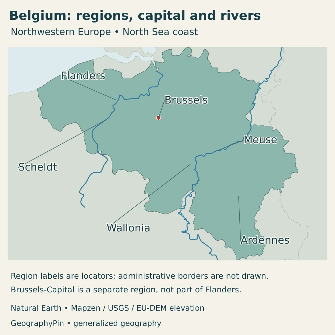
Brussels lies inland, while Antwerp connects with the Scheldt river corridor. The Ardennes occupy higher country toward the southeast. These are useful reference points, but they represent different kinds of places: a capital, a port-city setting and a broad physical landscape.
The names Flanders and Wallonia refer here to Belgium’s territorial regions. They should not be read as two independent countries or as exact equivalents of “coastal plain” and “Ardennes.” Brussels-Capital is a third region in its own right.
For the wider setting, see our map of Europe’s countries. The European countries and capitals guide places Brussels among the continent’s other national capitals.
2. Country facts with dates and scope
| Measure | Value | Date or definition |
|---|---|---|
| Capital | Brussels | National capital; distinguish the City of Brussels municipality from the wider Brussels-Capital Region. |
| Population | 11,867,634 | Statbel registered population on January 1, 2026. |
| Total surface area | About 11,849 sq mi (30,690 km²) | Statbel 2025 administrative-area figure; not a dry-land-only measure. |
| Official languages | Dutch, French and German | Territorial language rules differ; Brussels-Capital is officially Dutch–French bilingual. |
| Currency | Euro (EUR) | Belgium belongs to the euro area. |
| Federal structure | Three regions and three communities | Two different kinds of federal entity, not six interchangeable territorial units. |
| Government | Federal constitutional monarchy | King as head of state; prime minister as head of government. |
The population figure is a dated national registration statistic, not a real-time counter or a count of Belgian citizens alone. Population totals using a different residence definition can differ even when they refer to the same country.
The area figure uses Statbel’s administrative measurement framework. Its coastal calculation includes the strip to the low-water line, and cadastral land-use categories include waters. It is therefore not appropriate to relabel this total as dry land.
3. Coastal plain, central plateaus and Ardennes
From the North Sea to the uplands
| Setting | Landscape | What it helps explain |
|---|---|---|
| Coast and polders | Sandy coast, dunes and low drained country. | The close relationship between settlement, agriculture and water management. |
| Interior lowlands | Broad low country with local hills and a mixture of farmland, woodland and urban land. | Low relief does not mean a uniform or entirely rural landscape. |
| Central plateaus | Gently rising, often cultivated country between the northern lowlands and the Sambre–Meuse corridor. | A transition toward the higher and more dissected southeast. |
| Ardennes and neighboring uplands | Wooded plateaus, hills and deeply cut valleys. | Greater relief and a different pattern of forests, settlements and river corridors. |
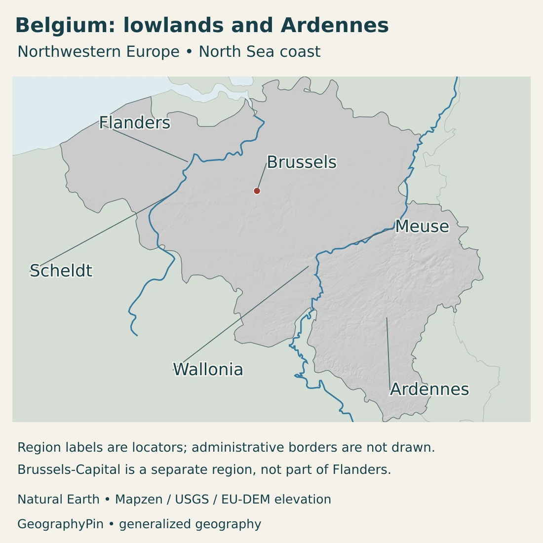
Behind the coast, polders are landscapes shaped by drainage and protection from tidal water. Farther inland, the lowlands include sandy districts and local rises. A flat-looking national map can hide meaningful differences between dunes, drained farmland and built-up land.
The central country rises gradually toward the Sambre and Meuse valleys. Fertile cultivated plateaus form an important part of this transition. These landscapes are lower and more open than the wooded uplands farther southeast.
The Ardennes are not a single narrow ridge. Plateaus and incised valleys create a varied upland landscape. Wallonia also contains other settings, including the Condroz plateau, the Fagne–Famenne belt and the Meuse valley. Calling all of Wallonia “the Ardennes” would erase those differences.
Valleys connect places within the higher country
The Meuse valley offers a clear example of how a river shapes settlement within a region of varied relief. Towns and historic fortifications occupy a corridor that cuts through the landscape rather than following a simple north–south division.
In the Fagne–Famenne area, limestone and rolling terrain create a different setting from the more wooded Ardennes plateaus. Toward the east, peatlands and forests add another distinctive environment. These contrasts are better understood as a mosaic than as three sharply separated elevation bands.
Physical regions and institutions overlap, but they answer different questions. Relief explains slopes, drainage and some land uses; a regional boundary identifies a jurisdiction. Neither map alone explains the country completely.
4. Maritime climate and international river basins
Belgium has a temperate maritime climate influenced by the nearby Atlantic Ocean. Westerly airflow often brings moisture, while changing air masses produce variable weather. Maritime influence moderates conditions, but it does not prevent unusually hot, cold, wet or dry periods.
Distance from the sea and altitude help explain regional contrasts. The coast generally has milder winters and cooler summers than inland places. The higher Ardennes and High Fens are cooler than much of the low country.
A forecast for Brussels therefore cannot stand in for the whole country. Coastal conditions, inland urban conditions and those on an upland plateau can differ substantially without being far apart on a national map.
The Scheldt and Meuse are the main systems, not the only ones
The Scheldt, also called the Escaut in French, and the Meuse, or Maas in Dutch, are Belgium’s principal river-basin systems. The Scheldt is chiefly a lowland river system; the Meuse basin includes higher, more deeply dissected country.
Smaller parts of Belgium also belong to the Rhine and Seine basins. A basin boundary follows the land draining toward a river system, not a political or language boundary. International cooperation is therefore necessary even when water is managed through regional institutions.
The European Commission’s 2025 water assessment distinguishes those management arrangements from the physical catchments. Brussels belongs to the Scheldt basin, while Walloon water planning covers portions of several river-basin districts.
Lowlands and valleys face different water pressures
In lowland areas, drainage, channels and developed floodplains strongly influence how water moves. In upland valleys, slope and the shape of the valley create a different physical setting. Neither should be reduced to a single national “flood risk” label.
Water quality and water quantity are separate issues. The Commission’s assessment identifies agricultural pollution, wastewater and changes to river form among Belgium’s pressures. A river can remain important for transport or urban life while still needing ecological restoration.
5. Cities, languages, regions and communities
Three regions are not the same as three communities
Belgium’s regions are the Flemish Region, the Walloon Region and the Brussels-Capital Region. Their responsibilities concern territory, including fields such as spatial planning, transport and the environment.
The Flemish, French and German-speaking Communities have a different purpose. They deal with language- and person-related fields such as culture and education. A community is not simply another name for the corresponding region.
Brussels makes the distinction especially clear. It is one territorial region, but both Flemish and French community institutions operate there. Residents are not required to adopt a separate community “subnationality” to use community services.
Brussels is a city name and a wider regional name
The Brussels-Capital Region comprises 19 municipalities. The City of Brussels is one of them, not an alternative name for the entire region. Local administration and the regional government consequently describe different territorial scales.
That scale distinction matters when comparing population, area or public services. A figure for one municipality cannot automatically describe the whole urban area, and a regional figure is not necessarily a measure of the continuously built-up city.
Languages are not a map of everyone’s identity
The Constitution distinguishes four linguistic areas: Dutch-speaking, French-speaking, German-speaking, and bilingual Brussels-Capital. These four areas are a different classification from the three territorial regions and the three communities.
Official language arrangements concern public institutions and territorial rules. They should not be read as a claim that every resident speaks only the designated language. Brussels is officially Dutch–French bilingual, while the German-speaking community adds another important dimension to Belgium’s language geography.
Multilingual place names can also make the same location look different across sources. Bruxelles and Brussel refer to Brussels; Antwerpen is Antwerp. The paired river names Scheldt–Escaut and Meuse–Maas are particularly useful when reading Dutch- and French-language maps.
6. Government and an economy of connections
Belgium is a federal constitutional monarchy. The king is head of state and the prime minister heads the federal government. Regions and communities have their own responsibilities rather than simply acting as interchangeable branches of the national administration.
Brussels combines Belgian and international roles. It is the national capital and one of the official seats of European institutions, alongside Luxembourg City and Strasbourg. Calling it the EU’s only institutional seat would be misleading.
Ports link the country to wider production networks
The Flemish ports connect maritime trade with industrial activity. Antwerp-Bruges combines cargo handling with a major chemical-industry presence. The Ghent part of North Sea Port has important steel and vehicle industries, while Ostend focuses on offshore activity and renewable-energy services.
Those examples show why a port is more than the point where a ship stops. Storage, processing, manufacturing and onward transport all occupy space around the maritime connection. The surrounding environment must also accommodate settlements, water management and habitat protection.
In Wallonia, the Hennuyer plateau retains visible traces of mining, including spoil heaps. This industrial heritage coexists with countryside and changing land uses; it is not a complete description of the region’s present economy.
Belgium’s small size does not make its geography simple. Coastal access, inland river corridors, upland terrain and layered institutions each influence how places are connected. Keeping those layers distinct is the key to understanding the country without reducing it to either a language divide or a list of cities.
Frequently Asked Questions
What is the difference between Belgium’s regions and communities?
Regions are territorial entities responsible for fields such as transport and spatial planning. Communities have language- and person-related responsibilities, including culture and education. Brussels is one region where both French and Flemish community institutions operate.
Is Brussels part of Flanders or Wallonia?
Brussels-Capital is a separate territorial region, not part of either the Flemish or Walloon Region. It is officially bilingual in Dutch and French.
Is Belgium flat?
Not entirely. Coastal and northern lowlands contrast with central plateaus and the more elevated, valley-cut Ardennes and neighboring uplands in the southeast.
What Did We Learn Today?
Belgium combines North Sea lowlands, central plateaus and southeastern uplands with a federal system built around different territorial and community responsibilities. Brussels is both the national capital and a distinct region. River basins cross those institutional divisions, while ports and urban corridors connect the country to its neighbors and beyond.
Sources & Data Notes
Reviewed in November 2026. Population uses Statbel’s national registration definition and January 2026 reference date; area uses its 2025 administrative total. Physical landscapes, river basins, territorial regions, linguistic areas and communities are distinct frameworks.
- Statbel, population on January 1, 2026: National registered population of 11,867,634; release dated June 10, 2026.
- Statbel, population calculation methodology: The national definition includes registered authorized foreign residents and excludes the asylum waiting register. European usual-residence series can differ.
- Statbel, land cover and administrative area: 2025 total surface area of 30,690 km². CADGIS methodology includes the coastal strip to the low-water line and cadastral water categories; this is not dry land alone.
- Belgian Senate, Constitution: Articles 1–4 distinguish the federal state, three communities, three territorial regions and four linguistic areas.
- Brussels-Capital Region, community institutions: Territorial and community responsibilities, bilingual Brussels and overlapping community institutions without a compulsory community subnationality.
- Brussels-Capital Region, municipalities: The region’s 19 municipalities, including the City of Brussels.
- European Union, Belgium overview: Capital, constitutional monarchy, euro and Brussels’ institutional role alongside Luxembourg City and Strasbourg.
- Belgian federal government, geography: Neighbors and the coast, polders, lowlands, central plateaus and uplands. Statistical area is taken separately from Statbel’s dated release.
- National Climate Commission, First Biennial Transparency Report: December 2024 report, geographical and environmental context, especially pages 12 and 67. Qualitative landscape information rather than older population figures.
- Wallonia, landscape settings: Ardennes, Fagne–Famenne, Condroz, Meuse valley and the Hennuyer plateau’s mining heritage.
- Royal Meteorological Institute, Belgian climate: Atlantic influence, changing air masses and maritime climate. Historical examples are not treated as current records.
- Royal Meteorological Institute, climate atlas: Qualitative temperature contrasts with distance from the sea and altitude.
- European Commission, Belgium water assessment: February 2025 assessment: Scheldt, Meuse, Rhine and Seine basin connections; regional management and water pressures. This is not a real-time flood or water-quality bulletin.
- Flemish government, ports: Qualitative port and industrial functions at Antwerp-Bruges, Ghent and Ostend; no historical employment figures or old construction schedule used.
Map sources and scope: Original GeographyPin maps use public-domain Natural Earth country boundaries, populated-place coordinate attributes, rivers and lakes. The complete Belgium source outline is retained, but tiny Baarle enclave and exclave boundaries are absent at this generalized scale. This is not a cadastral or navigation map.
Brussels uses the source city coordinates, not the boundary of the Brussels-Capital Region. Flanders and Wallonia are regional locator labels; the Ardennes label identifies a broad upland setting. No administrative-region or community boundaries are invented. Scheldt and Meuse lines follow the source river geometry, with source lake polygons retained; these are not measurements of current water levels or flows.
Hillshade is calculated from genuine elevations accessed through Mapzen Terrain Tiles, with no vertical exaggeration. Global elevation data courtesy of the U.S. Geological Survey. Produced using Copernicus data and information funded by the European Union – EU-DEM layers. Elevation-source attribution and terms apply. Shading is not bathymetry or a set of numerical elevation bands.
The cover uses Belgian national flag artwork from Commons, by Dbenbenn and other contributors. The complete flag preserves the official 15:13 proportions and is shown separately from the decorative outline motif.
