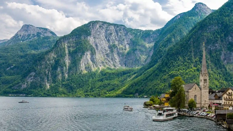
Austria is often pictured as a country of high peaks, but its map tells a broader story. Alpine valleys connect towns and transport routes, the Danube crosses settled northern and eastern country, and lowland landscapes extend toward Hungary. Understanding these contrasts explains why Vienna, Salzburg and Innsbruck occupy such different geographic settings.
Austria is a landlocked country in Central Europe with Vienna as its capital. The Eastern Alps dominate much of the west and south, but Austria also includes Alpine forelands, the Danube corridor, northern granite and gneiss uplands, and lower country in the east. It is a federal republic with nine states. Most, but not all, of its territory drains toward the Danube.
How to use this article: Compare mountains and lowlands, follow the three river-basin connections, or clarify Vienna’s city and state roles.
1. Locate Austria in Central Europe
Austria borders Germany, Czechia, Slovakia, Hungary, Slovenia, Italy, Switzerland and Liechtenstein. It has no sea coast. Its position places it between the Alpine world, the Danube corridor and the plains of east-central Europe.
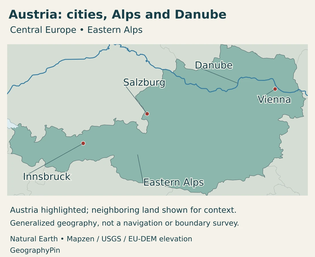
Vienna lies in the east rather than in the high central Alpine belt. Salzburg occupies a setting near the northern Alpine edge, while Innsbruck lies within the mountains in the Inn valley. These locations provide useful reference points for reading the country from east to west.
Austria and Australia are different countries on different continents. Austria’s German name, Österreich, refers to this European state. Neither the similarity of the English names nor Austria’s mountain imagery should obscure its actual position among eight European neighbors.
Mountains and river corridors cross borders
The Alps extend across several countries, so Austria is neither the whole Alpine region nor an isolated mountain block. Likewise, the Danube enters and leaves Austria as part of a much larger international river system.
Our Danube River map follows that wider route. The major mountain ranges guide places the Alps in a broader physical-geography context.
2. Country facts with dates and definitions
| Measure | Value | Date or definition |
|---|---|---|
| Capital | Vienna | Seat of the highest federal authorities; also a federal state and municipality. |
| Population | 9,228,795 | Preliminary registered resident population on October 1, 2026; compiled November 10. |
| Published total area | About 32,388 sq mi (83,884 km²) | Statistics Austria, 2025/26 publication; rounded from 83,884.29 km². |
| State language | German | Without prejudice to statutory minority-language rights; Austrian Sign Language is separately recognized. |
| Currency | Euro (EUR) | Austria is a member of the euro area. |
| Federal structure | Nine states | Also called federal provinces or Bundesländer; Vienna is one of them. |
| Government | Federal parliamentary republic | President as head of state; chancellor as head of government. |
The population figure is a preliminary register-based count for its stated date. It describes residents rather than Austrian citizens alone and should not be confused with a census enumeration or an undated population estimate.
National area, a state’s administrative area and a river catchment’s area answer different questions. Mountain-region boundaries are different again: a physical region may cross several federal states, and one state may include more than one landscape type.
3. Eastern Alps, forelands and the lowland east
The main landscapes are not all high mountains
| Setting | Terrain | Geographic importance |
|---|---|---|
| Eastern Alps | Mountain groups, steep slopes and intervening valleys. | Much of western and southern Austria; routes and settlements concentrate in usable corridors. |
| Alpine forelands | Lower hills, fields and lake districts near the mountain margin. | A transition between high relief and the more open country toward the Danube. |
| Northern granite and gneiss uplands | Part of the Bohemian Massif north of the Danube. | Older upland landscapes distinct from the high Alpine chains. |
| Vienna Basin and eastern lowlands | Lower, more open terrain at the eastern Alpine margin. | Major settlement, farming and transport connections. |
| Southeastern basins and hills | Lower country, including the Graz Basin. | Another important settled setting that differs from both the high Alps and the northern uplands. |
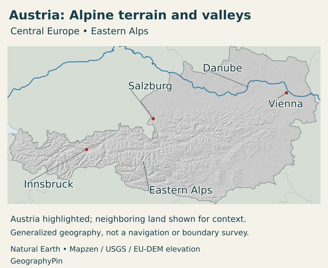
The Eastern Alps are a system of ranges and valleys, not a single ridge of uniform height. Northern limestone terrain differs from other Alpine rock belts, and valley floors can lie far below nearby summits. A mountainous region can therefore contain substantial urban and agricultural space.
Gesäuse National Park offers a concrete geological example. Its mountains belong to the Northern Limestone Alps, where limestone and dolomite are prominent. Ice once occupied the Enns valley, while river erosion, frost weathering and the movement of rock continue to modify the landscape.
This combination matters when interpreting relief. Bedrock history explains part of the structure, while glaciers and rivers helped shape valleys and steep slopes. Present scenery is the result of several processes acting over different timescales.
The Alpine forelands offer a gentler contrast: lower hills, fields and lakes replace some of the abrupt relief of the mountain interior. North of the Danube, the Bohemian Massif’s granite and gneiss uplands form another distinct setting.
In the east, the Vienna Basin and Pannonian-influenced lowlands contain broad open areas, agricultural land and important settlement corridors. The transition is not a simple border between “mountain Austria” and “flat Austria”; hills and basins overlap along the Alpine edge.
An eastern lake landscape unlike the high Alps
Lake Neusiedl and the Seewinkel provide a particularly clear contrast. On the Austrian–Hungarian border, reed beds, meadows, dry grasslands and saline pools form a lowland wetland mosaic. This setting is very different from a lake enclosed by steep Alpine slopes.
Some of the small soda pools dry periodically, creating specialized habitats. A lake symbol alone cannot convey those differences in water depth, chemistry or seasonal behavior. Our Lake Hallstatt profile explores a contrasting Alpine lake setting in more detail.
4. Climate and rivers across the mountain divide
Austria’s climate changes with elevation and position. The west and north are more exposed to moist westerly air, while eastern areas have a stronger continental or Pannonian influence. Eastern summers can be warm or hot with comparatively lower rainfall, while the Alpine interior experiences longer snowy winters.
These are regional tendencies, not a forecast for every valley. A high slope and the town below it can experience different conditions on the same day. Mountain relief also changes how air moves and where precipitation falls.
The same contrasts influence land use. Open lowland areas, wooded foothills and high Alpine pastures do not offer identical growing conditions. Describing the entire country with one average temperature would miss much of its useful geographic variation.
Most rivers connect to the Danube, but not all
The water ministry identifies three international river-basin districts within Austria: the Danube, Rhine and Elbe. The Danube district covers the overwhelming majority of the country; smaller areas connect to the Rhine in the west and the Elbe system in the north.
The Elbe itself does not flow through Austria. Austrian tributaries connect to its wider basin. This distinction is important: belonging to a river basin does not mean that the main river crosses every part of it.
The Inn, Drava and Morava, also known in German as Drau and March for the latter two, are important connections within the Danube system. Rivers and tributaries link mountain catchments with lower country across national boundaries.
The Danube is also a living floodplain
East of Vienna, Donau-Auen National Park protects a floodplain landscape on the way toward Bratislava. River channels, side waters and floodplain habitats form an interconnected environment rather than a simple blue line.
Water levels vary, and the connection between the main river and side channels changes with them. Elsewhere, engineering and hydropower structures have modified the river. A national map cannot by itself show which stretches are free-flowing or how a floodplain functions.
Austria’s rivers therefore serve several roles at once: drainage systems, habitats, transport routes and energy resources. These roles can require different kinds of management within the same valley.
5. Cities, federal states and languages
Vienna is the national capital and a major eastern urban center. Linz lies on the Danube farther west, Salzburg near the northern Alpine margin, and Innsbruck in the Inn valley. Graz occupies a basin setting in the southeast.
The pattern helps explain why Austria is not settled evenly across its surface. Broad valleys, plains and basins provide more continuous space for buildings, transport and cultivation than steep mountain slopes. Mountain regions still contain important towns and cities, rather than being empty areas between lowland centers.
Vienna is both a city and a federal state
Austria comprises nine federal states, also called federal provinces or Bundesländer: Burgenland, Carinthia, Lower Austria, Upper Austria, Salzburg, Styria, Tyrol, Vorarlberg and Vienna. They are political units, not a classification of nine natural landscapes.
Vienna has three connected roles: federal capital, federal state and municipality. Its status as a state does not make it a second country, and the national government’s presence does not replace its local administration.
Lower Austria is a separate state, despite its close geographic relationship with Vienna. A statistic for Vienna, Lower Austria or a wider metropolitan area therefore needs its own territorial definition.
German and regional language rights
German is Austria’s state language under the Federal Constitution, without prejudice to minority-language rights established by law. Croatian, Slovenian and Hungarian have recognized roles in specified regional contexts. Austrian Sign Language is separately recognized as an independent language.
These legal categories do not mean that every locality has the same language arrangements. They also do not describe every language spoken by residents. The distinction between nationwide status and regional rights is more useful than calling the country simply monolingual.
Place names may appear in German and English forms. Wien is Vienna, and Donau is the Danube. Recognizing those pairs makes it easier to connect local signs and source documents with English-language maps.
6. Government, transport and economic geography
Austria is a federal parliamentary republic. The president is head of state and the federal chancellor is head of government. The national parliament has two chambers, the National Council and Federal Council. Federal and state institutions share responsibilities within the constitutional system.
Austria’s position creates an economic geography of connections as well as barriers. Mountain routes link northern and southern Europe, while the Danube corridor links industrial and urban places across the country and beyond it.
The Brenner route illustrates the Alpine challenge. The Brenner Base Tunnel project connects the Innsbruck area with Fortezza in Italy through a low-gradient railway alignment. The purpose of a base tunnel is to address the gradients and constraints of a mountain crossing, not to remove the mountains from the wider transport system.
As reviewed in November 2026, the project description refers to future operation. It should not be mistaken for an already operating passenger route. Its geography nevertheless shows why engineering choices, valley locations and cross-border coordination matter.
Industry is also broader than the mountain-tourism image suggests. Austria’s official country information identifies machinery and steel, chemicals and vehicles, electrical and electronic goods, food, and wood and paper among important industrial branches.
The Danube provides another connection between economic activity and physical geography. Transport, hydropower and floodplain conservation share a river corridor, making its management more complex than maximizing a single use.
Tourism draws on both mountain and lowland landscapes, but the country’s geographic identity is not limited to ski slopes. Cities, agricultural areas, wetlands and river valleys all form part of the same national picture.
The most useful way to understand Austria is therefore to keep its contrasts connected: Eastern Alps and lower basins, mountain crossings and river corridors, federal states and physical regions. None of those pairs can be substituted for the other.
Frequently Asked Questions
Is Austria entirely mountainous?
No. The Eastern Alps dominate much of the west and south, but Austria also includes Alpine forelands, northern uplands, the Danube corridor, the Vienna Basin and lower country in the east.
Does every Austrian river drain to the Danube?
No. Most of Austria belongs to the Danube basin district, but smaller areas belong to the Rhine and Elbe systems. The Elbe itself does not flow through Austria.
Is Vienna part of Lower Austria?
Vienna is a separate federal state as well as Austria’s capital city. Lower Austria is another state, so their administrative statistics should not be treated as interchangeable.
What Did We Learn Today?
Austria is a landlocked Central European country whose geography extends beyond the Alps. Mountain valleys, the Danube corridor, northern uplands and eastern lowlands create different settings for settlement and activity. Most of the country drains toward the Danube, but the Rhine and Elbe also have Austrian catchments. Vienna combines national-capital, city and federal-state roles.
Sources & Data Notes
Reviewed in November 2026. Population is a preliminary October register figure. Area is the rounded total published by Statistics Austria, not a separately calculated dry-land area. Federal-state boundaries and physical regions are different geographic frameworks.
- Statistics Austria, population at the beginning of each quarter: Preliminary October 1, 2026 population of 9,228,795. The register includes people with a main residence for more than 90 days around the reference date.
- Statistics Austria, Austria: Data, Figures, Facts 2025/26: Area table on page 9 reports 83,884.29 km² as total area, rounded in this profile. No separate dry-land/water split or new survey date is inferred. Geographic and climate context also informs the comparison.
- Austrian Parliament, federal state: Nine federal provinces and the sharing of federal and state functions.
- City of Vienna, federal capital: Vienna’s simultaneous roles as capital, state and municipality.
- Federal Constitution, Article 8: German state language, minority rights and separate recognition of Austrian Sign Language.
- Austrian government, languages: Regional Croatian, Slovenian and Hungarian language contexts.
- European Union, Austria overview: Institutional roles, two parliamentary chambers and euro-area membership.
- Austrian Foreign Ministry, geography: Neighbors, broad Alpine and non-Alpine settings, and settlement in plains and basins.
- Austria Tourism, landscape regions: Alpine forelands, northern granite and gneiss uplands, Vienna Basin and eastern lowland landscape contrasts.
- Gesäuse National Park, geology: Northern Limestone Alps, limestone and dolomite, glacial history and continuing river and weathering processes.
- Austrian government, geography and economic structure: Qualitative climate contrasts and industrial branches.
- Water ministry, river-basin districts: Danube, Rhine and Elbe basin membership; the Elbe main river does not flow through Austria.
- National Parks Austria, Neusiedler See–Seewinkel: Lowland wetland mosaic, reed beds and periodically drying soda pools.
- National Parks Austria, Donau-Auen: Floodplain between Vienna and Bratislava and water-level-dependent habitat connections.
- Donau-Auen National Park, the Danube: River regulation, hydropower, floodplain processes and remaining free-flowing stretches.
- Brenner Base Tunnel, project overview: Innsbruck–Fortezza low-gradient railway project; future operation, not an assertion of an already operating route.
Map sources and scope: Original GeographyPin maps use public-domain Natural Earth national boundaries, populated-place coordinate attributes, rivers and lakes. Austria’s complete source geometry is retained. These generalized boundaries are not an official boundary survey.
Vienna, Salzburg and Innsbruck use source city coordinates. The Eastern Alps label marks a broad mountain location rather than a defined physical-region boundary. The Danube follows actual source lines without invented connections. Full source lake polygons are retained across national borders; water geometry does not show current levels, flows or navigation channels.
Hillshade derives from genuine elevations accessed through Mapzen Terrain Tiles. Global elevation data courtesy of the U.S. Geological Survey. Produced using Copernicus data and information funded by the European Union – EU-DEM layers. Elevation-source attribution and terms apply. Shading uses no vertical exaggeration and is not bathymetry or numerical elevation bands.
The cover uses Austrian flag artwork from Commons, credited to the Federal Ministry of Defence. The complete red-white-red flag is shown separately from the decorative silhouette motif.