The hardest part of choosing between these parks is deciding what you want to see once you get out of the car. One puts you near sandstone arches; the other lets you look down into a landscape carved by rivers.
Choose Arches if you want to see sandstone formations close up or have only a few hours from Moab. Choose Canyonlands’ Island in the Sky district if wide canyon views are the priority and you can spend longer driving. For very little walking, Arches has a roadside view of Balanced Rock, while Canyonlands’ Grand View Point has a short paved approach.
How to use this article: Try the one-day comparison, see the approach map, or go to the shorter-walk choices.
Which park fits your day?
Pick the experience before picking the park
Both parks work without a long hike, but you get something different in each. At Arches, look up at individual formations. At Canyonlands, look out over layers of cliffs and canyons. For a day starting and ending in Moab, compare Arches with Island in the Sky, not the farther-away Needles or Maze districts.
| If you want | Choose | What to know |
|---|---|---|
| A shorter drive and a memorable roadside formation | Arches | Balanced Rock is visible from the road; the full loop is optional. |
| Several wide overlooks with little walking | Island in the Sky | Buck Canyon, Green River and Grand View Point have wheelchair-accessible overlooks. |
| A short walk to see an arch | Arches for the Windows; Canyonlands for Mesa Arch | The full Windows loop has stairs; Mesa Arch is shorter but has uneven rock and steps. |
How much driving does each park add?
Start both comparisons in Moab
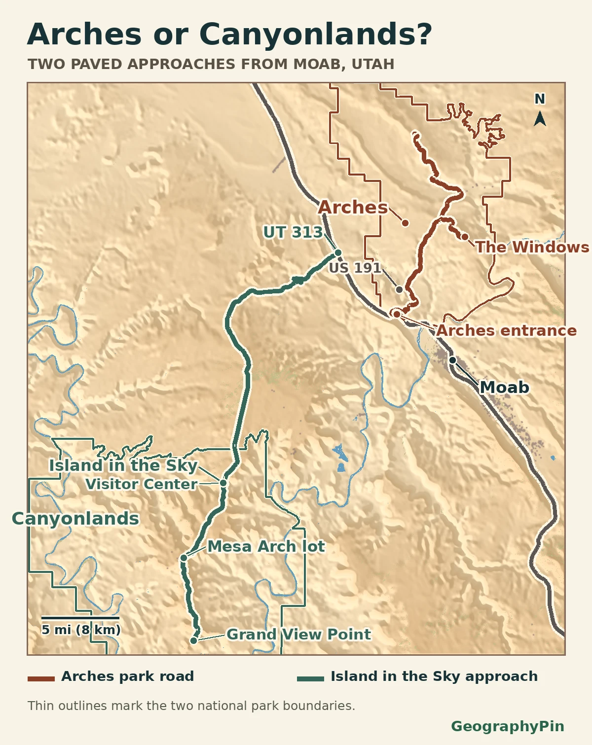
The Arches entrance is about 5 miles (8 km) north of Moab. The National Park Service lists another 9.2 miles (14.8 km) and 15–20 minutes from the entrance to Balanced Rock, or 12 miles (19 km) and 25–30 minutes to the Windows. Adding the approach puts those stops about 14 and 17 miles (23 and 27 km) from Moab, before any detours. The published driving times cover the in-park portion only.
For Island in the Sky, use US 191 north and the UT 313 approach. NPS puts the visitor center about 32 miles (51 km) and 40 minutes from Moab. The overlooks are farther along the park road. If you only have two hours including the drive back, making it to the visitor center doesn’t leave much time for those stops.
Overlooks, short walks and uneven ground
Decide how much walking you want to do
At Arches, try Balanced Rock if you’d prefer to stay by the road or take a brief walk. The first section of the path is paved, but the complete loop is not. At the Windows, don’t mistake a short distance for a level walk: the main 1-mile (1.6-km) loop climbs and includes steps.
In Canyonlands, Grand View Point’s paved overlook is a different stop from the longer hike that starts nearby. You can see the canyon from the overlook without taking the trail. Mesa Arch is a separate 0.6-mile (1-km) round trip over uneven rock and steps, not a paved alternative. If walking or standing is limited, pick the overlooks rather than building the day around that trail.
What to check before leaving Moab
Check the road, then the shuttle
On Nov. 19, 2026, Canyonlands listed Island in the Sky’s paved scenic drive as open. That report is not a guarantee for a later trip. Check both parks’ current conditions for road alerts, then check your planned stop for any trailhead, overlook or parking restrictions.
The Arches shuttle was not running at the November 21, 2026 check. Discover Moab lists a scheduled return on March 1, 2027; confirm service and stops before relying on it. Arches did not require a timed-entry reservation for 2026, but that decision was year-specific and did not remove the entrance fee or ensure parking. Check the rules for the year and date you’ll actually visit.
Is it worth visiting both in one day?
Give the park you most want to see the most time
If your goal is to see one formation in Arches and one canyon panorama at Island in the Sky, a two-park day may be possible. Look up both approach drives separately, count time for parking and decide which stop to drop if the morning runs long. There isn’t a short park-road shortcut from Arches to Island in the Sky. If you want a meaningful hike or an unhurried look around, give one park the day instead.
Same start, two round trips: From Main and Center streets in Moab, drive to the Balanced Rock parking turnoff and back for about 29 miles (46 km), or to the Grand View Point parking approach and back for about 89 miles (143 km). Both estimates follow the paved approach and count the same route back. They exclude driving around the parking lots, other stops, walking and any detours. They tell you how far you’ll drive, not how long to spend in either park.
Frequently Asked Questions
Which park is better if I can’t do a long hike?
For the least driving, choose the roadside view of Balanced Rock in Arches. For a broader panorama and a paved walk from parking, consider Grand View Point in Canyonlands. If you use a wheelchair, NPS identifies three accessible Canyonlands overlooks; don’t assume the nearby Mesa Arch trail is one of them.
Is the Needles district a substitute for Island in the Sky on this one-day route?
No. Island in the Sky is the northern approach from US 191 via UT 313. To reach the Needles, drive south from Moab on US 191 and turn west on UT 211. It requires a separate plan and does not use the same route.
Where can I check whether the parks are open in winter?
Use each park’s NPS Current Conditions page and the separate Canyonlands Road Conditions report. Check the specific road or stop you need: a park can remain open while one road, lot or trail is restricted.
What Did We Learn Today?
Arches is the closer choice for sandstone formations; Island in the Sky is the better choice for canyon panoramas if you can spare the longer drive. When walking matters, choose the individual stop by its surface and slope, not just by trail length.
Sources & Data Notes
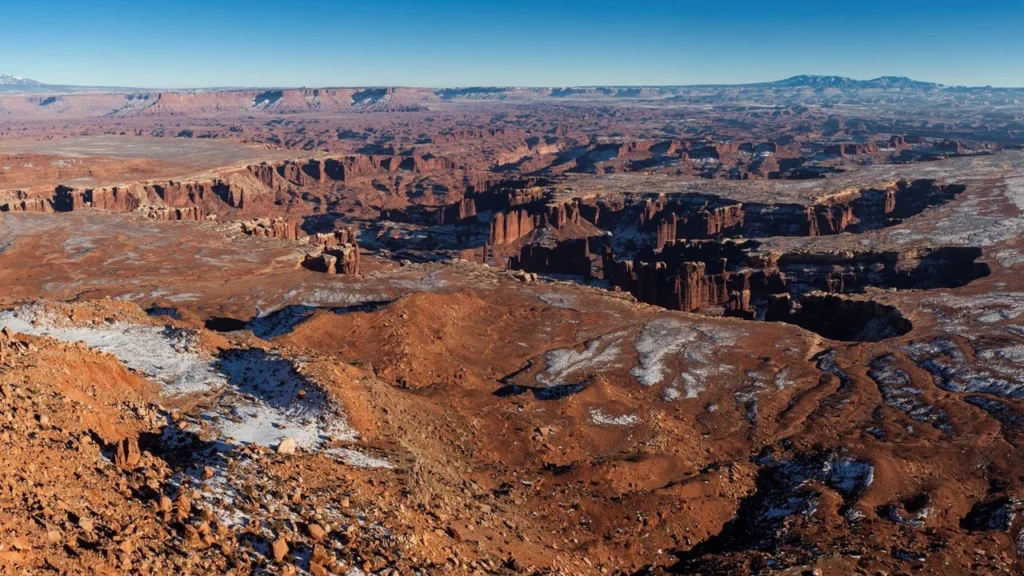
Directions and conditions were reviewed for November 2026. Distances from Moab to stops in Arches are sums of rounded NPS distances; they are not independent measurements. The separate round-trip examples measure UDOT road centerlines, NPS Public Roads and connecting OpenStreetMap segments from the same Moab junction to each paved parking approach and back. See NPS directions to the Needles for that separate approach. The route map shows selected physical roads and mapped park boundaries, not live access. Cartography: GeographyPin. Roads and boundaries: NPS and UDOT, with connecting road segments © OpenStreetMap contributors (ODbL). Terrain: Mapzen/USGS. Water: © ESA WorldCover project 2021; contains modified Copernicus Sentinel data (2021) processed by the ESA WorldCover consortium. Featured photograph: NPS / Jacob W. Frank, public domain; cropped for this article.
- Arches National Park: directions from Moab
- Arches National Park: in-park road distances and times
- NPS: Balanced Rock viewing area
- Arches National Park: mobility and trail surfaces
- Arches National Park: current conditions
- Arches National Park: 2026 timed-entry decision
- Arches National Park: fall 2026 pilot shuttle
- Discover Moab: seasonal shuttle schedule
- Canyonlands National Park: Island in the Sky directions
- Canyonlands National Park: road conditions
- Canyonlands National Park: current conditions
- Canyonlands National Park: accessible overlooks
- NPS: Grand View Point overlook and featured photograph
- Canyonlands National Park: Mesa Arch trail distance
- NPS: Mesa Arch trail surface
- Utah Geospatial Resource Center: highway routes
- OpenStreetMap: credit and data license
- ESA WorldCover: surface water dataset