Arches National Park has one main paved drive, but it’s easy to lose time at the wrong turnoff. At Delicate Arch, for example, the parking lot for the hike and the parking lot for the distant view are a mile apart.
Arches Scenic Drive runs 18 miles one way from the entrance and visitor-center area north of Moab to Devils Garden. Take Windows Road for several arches in one stop, or take Delicate Arch Road for Wolfe Ranch and the separate viewpoint lot. Both are paved branches. Most visitors return the same way rather than driving a loop.
How to use this article: Start with the road map, compare the two paved detours, then check entry and shuttle dates before choosing how to get there.
Follow the paved road north from Moab
Read the main and side roads separately
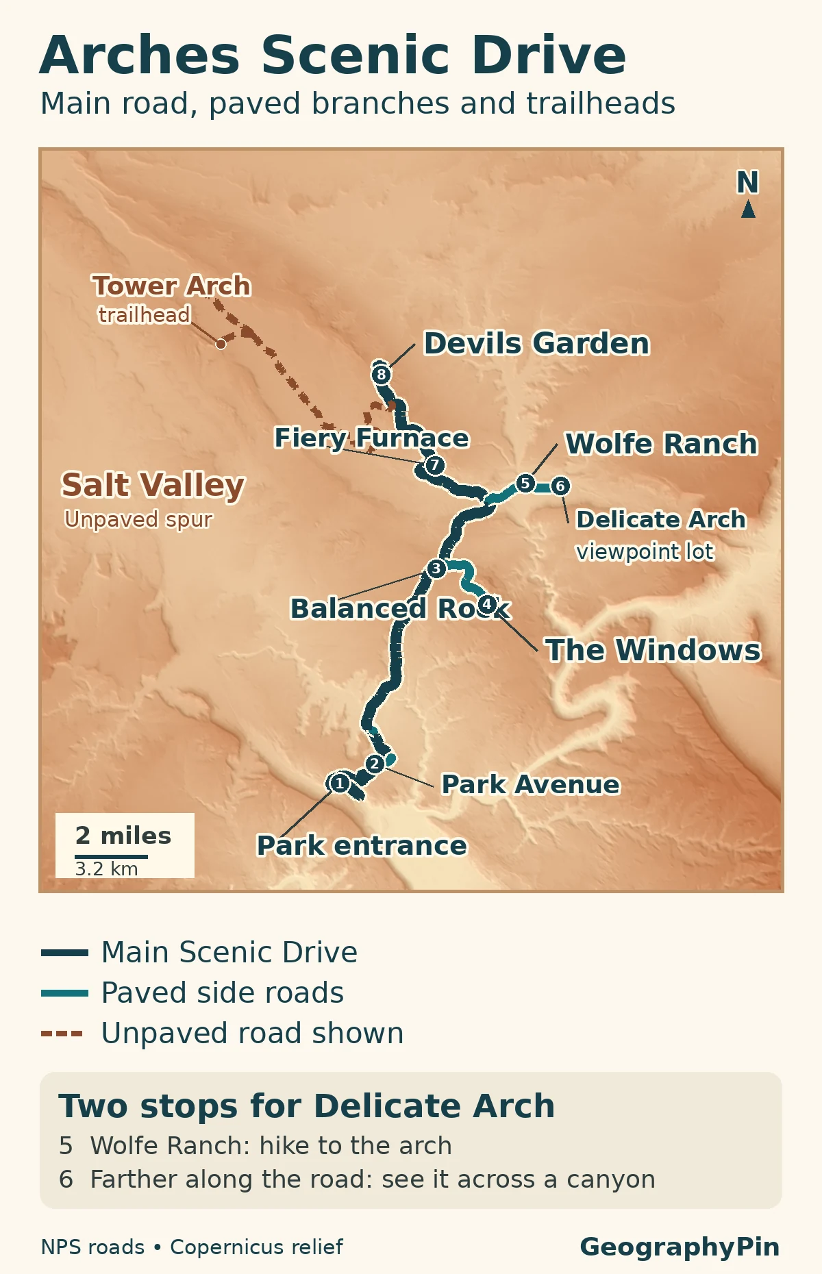
The regular entrance is off US 191 north of Moab. The main road climbs from the visitor-center area into the park, then passes Park Avenue and Courthouse Towers before reaching Balanced Rock. You do not need to take an unpaved turn to reach any of the stops on the main drive or the two major paved side roads. On the map, dark blue takes you to Devils Garden; teal takes you down a paved branch. Go back to the junction after each detour.
| Stop | Distance | Typical driving time |
|---|---|---|
| Balanced Rock | 9.2 mi (14.8 km) | 15–20 min |
| The Windows | 12 mi (19.3 km) | 25–30 min |
| Wolfe Ranch trailhead | 13.2 mi (21.2 km) | 30–35 min |
| Delicate Arch viewpoints | 14.2 mi (22.8 km) | 30–35 min |
| Devils Garden | 18 mi (about 29 km) | 40–45 min |
The Windows or Delicate Arch?
Pick the stop that matches the walk you want
For Delicate Arch, choose the parking lot by the walk you want. Wolfe Ranch is the start of the full hike to the arch. The farther Delicate Arch Viewpoint lot is the start of the short walks to distant views.
Choose the Windows if you want a cluster of arches without committing to a long hike. Windows Road turns off just beyond Balanced Rock. North Window, Turret Arch and Double Arch are all reached from the same general parking area. Double Arch has a mostly hard-packed approach with some slopes and sand near the end. The first stretch of the Windows Trail is level and hardened, but stone steps begin farther on.
Choose Delicate Arch Road if seeing that particular arch is the priority. For the full hike, stop at Wolfe Ranch. The National Park Service lists a three-mile (4.8 km) round trip and 480 feet (146 m) of climbing from that trailhead. For a brief stop, drive another mile to the Delicate Arch Viewpoints lot. The lower viewpoint has a short, hard-surfaced approach and a distant view; the upper one climbs steps for another angle across the canyon. Neither viewpoint trail takes you up to the arch itself.
If the Wolfe Ranch lot is full and you choose to start the full hike from the second lot, that is not a substitute trail. It adds about one mile of walking along the road each way to the actual trailhead.
What lies beyond the Delicate Arch turn
Stay on the main road for the Fiery Furnace viewpoint and the north end of the paved drive. The viewpoint gives you a look into narrow sandstone passages without entering them. Exploring the labyrinth itself is a separate activity: you need a reserved ranger-led hike or a self-guided permit.
Devils Garden is the farthest major stop on the paved drive. The trail to Landscape Arch is 1.9 miles (3.1 km) round trip from the trailhead according to the park’s current trail page. If you only want a roadside view, don’t count that hike as time spent driving. Nearby Skyline Arch and Sand Dune Arch have their own stops on the way.
Salt Valley Road branches away on the western side. The National Park Service says ordinary two-wheel drive can normally reach the Tower Arch trailhead via Salt Valley Road, but rain and snow can make dirt roads unsuitable or impassable. Do not treat the dotted line as a bypass around a full parking lot. Check with the park before leaving pavement.
How much time to leave for the drive
If you have about 90 minutes inside the gate, pick one paved detour rather than trying to drive to every named stop. With half a day, you can sample both branches and continue to Devils Garden, leaving time for the drive back. Swap in the full Delicate Arch hike only if you can give it its own block of time. The estimates above start at the park, not in Moab, and do not include waiting for a space.
Parking, entry rules and the seasonal shuttle
Check what is running before leaving Moab
Practical information checked: November 21, 2026.
For 2026, Arches removed general timed-entry reservations. Park entrance fees or an eligible pass still apply, and park staff may temporarily hold vehicles outside if congestion creates a safety problem. Check the NPS alerts and conditions and entrance webcam before setting out. If one parking lot is full, use a different stop and return later rather than waiting in the travel lane or parking on vegetation. Check 2027 entry rules separately once published.
The 2026 Moab–Arches shuttle season ended October 31. The local tourism office lists a planned restart of March 1, 2027. The original pilot used a transfer at the visitor center for the Windows and the Delicate Arch trailhead. Those stops are not the same as the farther Delicate Arch viewpoint or Devils Garden. Check the current shuttle schedule and stops if you are counting on that service; don’t plan around the expired fall timetable.
Frequently Asked Questions
Do I use the viewpoint lot or Wolfe Ranch to see Delicate Arch without the full hike?
Use the Delicate Arch Viewpoint lot. The Lower Viewpoint is a level walk of about 100 yards (91 m) from parking, with the arch about a mile away. The 3-mile (4.8 km) round-trip hike to the arch itself starts from Wolfe Ranch.
Can my dog walk from a parking area to an overlook?
No, not on the park’s trails or overlooks. Arches allows leashed pets on established roads, in parking lots, at picnic areas and in campgrounds. The park has separate rules for service animals.
What Did We Learn Today?
The main road links the south entrance to Devils Garden; the side roads determine which arches and walks fit your day. One decision matters most at Delicate Arch: use Wolfe Ranch to hike to the arch, and use the farther lot to see it from across the canyon.
Sources & Data Notes
Access information checked November 21, 2026. The NPS road distances are from the park entrance/visitor-center area, not the town of Moab. NPS pages give slightly different lengths for the very short Lower Delicate Arch viewpoint path, so it is described here without a numeric distance.
- National Park Service: official drive distances and times, Auto Touring and unpaved roads and Alerts & Conditions.
- NPS: Delicate Arch viewpoints and Wolfe Ranch hike, viewpoint access features, The Windows, Devils Garden and Fiery Furnace permits.
- NPS: 2026 timed-entry decision, fall shuttle pilot; Moab Office of Tourism: shuttle service dates.
- NPS: Park Avenue viewpoint and arch visibility and road touring and pet rules.
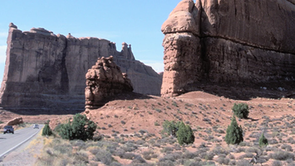
- Map by GeographyPin, based on NPS Public Roads and modified Copernicus DEM data (accessed 2026). It shows selected access roads, not the full backcountry network. Featured photograph: NPS/Neal Herbert, Touring the scenic drive at Arches, cropped and converted to WebP.