Canyonlands National Park has four districts: Island in the Sky, The Needles, The Maze and The Rivers. The three land districts have separate road approaches. Visiting the Green and Colorado rivers is a separate trip by water, not a way to complete a driving loop.
Choose the district before the route
Choose Island in the Sky for the simplest first visit by paved road, The Needles for a separate scenic-drive and walking day, and The Maze only for prepared remote travel. No roads or bridges directly connect Canyonlands’ districts inside the park. The fourth district, The Rivers, calls for separate boating plans.
Choose one district before planning the drive
Plan one district, not a park-wide driving loop
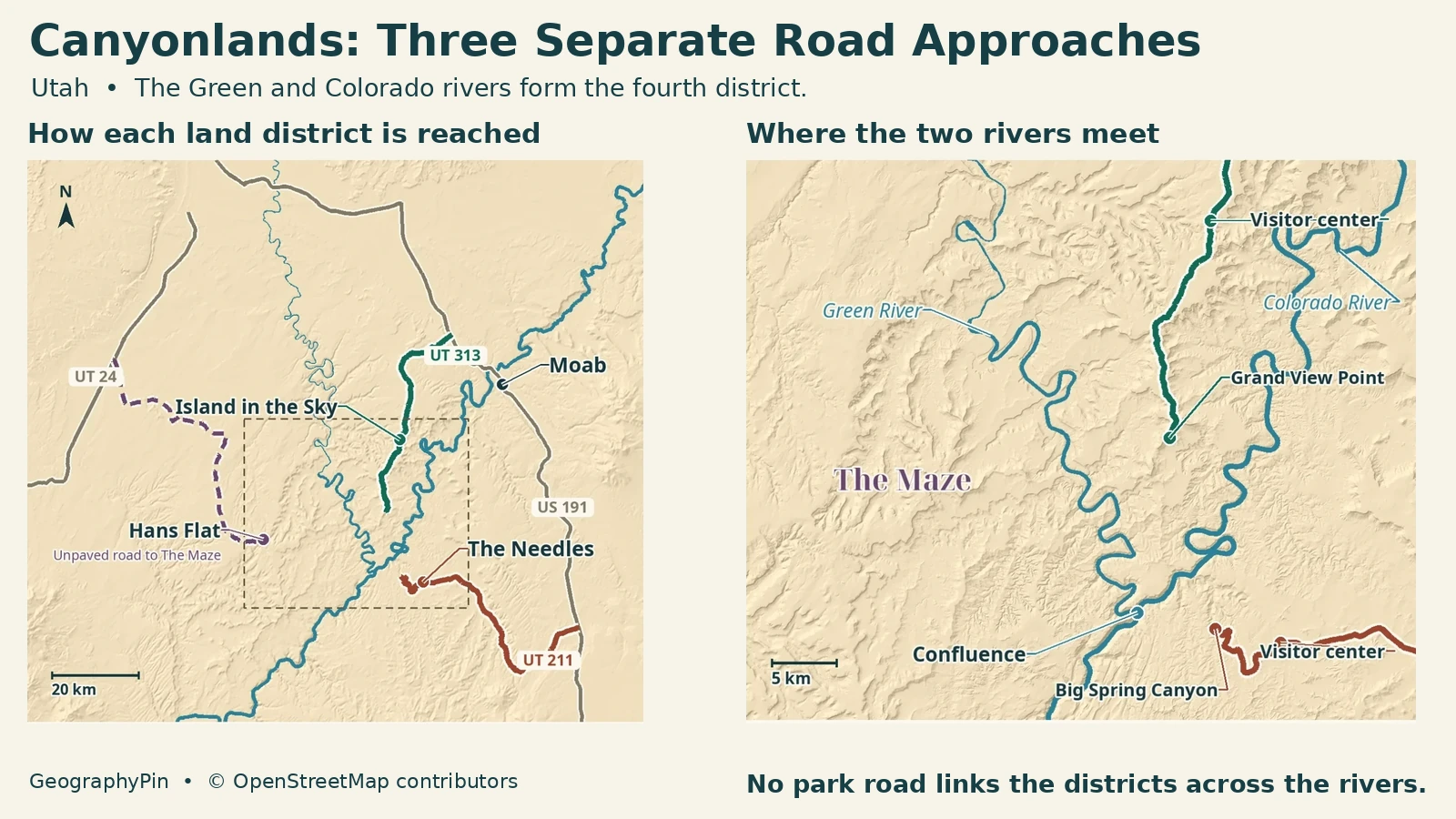
You cannot drive directly between Island in the Sky and The Needles inside Canyonlands. The Colorado and Green rivers divide the landscape, and no park roads or bridges link the districts across them. A short gap on a map can require a long journey back through the external road network.
For a first visit with a standard passenger car and limited time, Island in the Sky is the clearest starting choice. The Needles suits a visit built around its own scenic drive and selected walks. The Maze requires a different level of preparation and should not be added as a spontaneous third stop.
| Plan | District | Access distinction |
|---|---|---|
| Mesa-top overlooks on a short first visit | Island in the Sky. | Paved approach from US191 via UT313. |
| A separate day among sandstone spires and trails | The Needles. | Paved approach from US191 via UT211, not from Island in the Sky. |
| Prepared remote backcountry journey | The Maze. | Unpaved approach and demanding onward routes; suitable vehicle, skills and supplies essential. |
| A separate boating trip | The Rivers. | Plan the launch, take-out and permits separately; see NPS river trip planning. |
The National Park Service counts the Green and Colorado rivers as the fourth district, The Rivers. A boating trip needs a suitable launch, take-out, equipment and permit planning. The road map below does not show a boat route or guarantee river access.
Island in the Sky: views from the mesa
Stay on the mesa for the simplest overview
Island in the Sky is a high mesa above the surrounding canyons. Its paved scenic drive offers pullouts and trailheads, making it the easiest district to understand during a short visit. A view from above is the point of this itinerary; you do not need to descend to a river to appreciate the landscape.
Grand View Point and Green River Overlook are named orientation stops. They occupy different positions and should not be treated as interchangeable windows onto the exact river confluence. Use the official site description to decide what a particular overlook shows.
NPS describes the mesa-top scenic drive as a 34-mile round trip. That is not the distance from your accommodation to the park and back, and it does not include time spent walking. Build the approach, stops and return into the day separately.
The White Rim Road is a different route below the mesa, not the paved scenic drive under another name. Seeing its line from an overlook does not mean it is a suitable shortcut. It requires dedicated backcountry planning rather than an impromptu turn off the main visit.
The Needles: a separate southern approach
Use the southern approach for a different landscape
The Needles occupies Canyonlands’ southeastern area and takes its name from the sandstone spires. Its paved access is UT211 from US191 south of Moab. The road ends in this district; it does not continue through the park to Island in the Sky.
A standard-road visit can use the scenic drive and selected short walks. NPS describes the paved scenic drive as a 13-mile round trip. Big Spring Canyon Overlook is a useful road-access anchor; a trail destination deeper in the district requires a separate walking plan.
Places such as Chesler Park, the Joint Trail and Confluence Overlook should not be presented as equivalent roadside pullouts. Read the route description, distance and conditions for the chosen destination. A familiar place name on a small-scale park map can conceal a substantial final approach.
If visiting both Island in the Sky and The Needles, return to the outside highways between them. Two separate days often make a more coherent plan than trying to collect one photograph in each while spending much of the available daylight transferring.
The Maze begins beyond Hans Flat
Hans Flat is an approach point, not the finished trip
The Maze is the park’s least accessible district. Hans Flat Ranger Station is a planning and orientation point on the approach, not a gateway immediately beside every landmark. NPS describes further journeys into the canyons taking several hours by suitable high-clearance four-wheel-drive vehicle.
The approach from UT24 is unpaved. Do not rely on a generic description that it can be reached by two-wheel drive in ordinary conditions: the dated road bulletin can impose a much more demanding practical limitation after storms.
The Maze also differs in services. NPS states that food, fuel and potable water are not available there. A journey must be planned around self-sufficiency, the actual route and the possibility that weather prevents an easy exit. A visitor-centre icon is not evidence of a supply stop.
The rivers do not offer a casual way to complete a district-hopping loop. Above their confluence, flatwater boating is distinct from the powerful whitewater in Cataract Canyon below it. Do not improvise a crossing or assume a one-day river plan is exempt from the applicable rules. Combined river-and-land travel requires coordination with the park for the correct permits and itinerary.
Open roads still have vehicle restrictions
Read the dated bulletin and the vehicle requirement together
Check the National Park Service road bulletin for the district and road you plan to use. An open scenic drive tells you nothing about a backcountry spur. Rain, snow and mud can change unpaved roads quickly, and the latest Hans Flat entry may recommend a different vehicle from the park’s general Maze description.
For White Rim Road, NPS requires high clearance and four-wheel drive with low-range gearing. An ordinary all-wheel-drive vehicle is not an equivalent substitute. Having the required vehicle also does not cancel a closure or a permit requirement.
NPS requires day-use permits for specified backcountry roads, including White Rim and Elephant Hill, as well as permits for overnight backcountry trips. These are different from simply entering the park or taking the paved scenic drive. Confirm the permit for your actual activity instead of treating a park pass as authorization for every road.
Finally, match the symbol to the destination. A viewpoint, trailhead, ranger station and road terminus each mean something different. Carry the official map and current route information; do not let a navigation app connect two pins by selecting a road your vehicle or permit does not allow.
Frequently Asked Questions
Is the Needles Overlook the same destination as The Needles district?
No. Needles Overlook is a separate overlook outside the national park, managed by the Bureau of Land Management. Do not substitute that destination for the Needles Visitor Center when routing to the district.
What is the fourth district of Canyonlands?
The Rivers district follows the Green and Colorado rivers through the park. An overlook does not give you water access. Choose a launch and take-out for the river section you want, and check permit rules, flows and whether your trip includes whitewater.
What Did We Learn Today?
The main Canyonlands decision is which separate approach fits your time and vehicle. Mesa-top overlooks, Needles walks, Maze backcountry travel and river trips are different plans. Use the official map to distinguish road ends from trail destinations, then check the dated road bulletin before treating a mapped route as usable.
Sources & Data Notes
- Bureau of Land Management: Needles Overlook, separate from park district
- NPS: district approaches and absence of internal road connections
- NPS: four official districts
- NPS: The Rivers district
- NPS: Island in the Sky
- NPS: The Needles
- NPS: The Maze and Hans Flat
- NPS: scenic drives and backcountry permit distinctions
- NPS: dated road conditions and vehicle requirements
- NPS: boating and the river confluence
- NPS: river regulations and combined travel
Park classification and river guidance checked November 20, 2026. Follow the latest NPS bulletin for actual road conditions and vehicle recommendations, which can differ from the general district descriptions. Scenic-drive distances are NPS round-trip figures, not accommodation-to-park distances. No map line implies current access, a river ferry or an internal cross-district driving loop.
Map: Original GeographyPin cartography using audited connected roads and river geometry from © OpenStreetMap contributors, ODbL, retrieved November 19, 2026. UT 313 and the mesa roads, UT 211 and the main Needles road, and Lower San Rafael/Roost roads to Hans Flat are separate approaches. Through-road context: 2025 US Census TIGER/Line Utah county roads. Relief: AWS Terrain Tiles, mixed observation dates. No park boundaries, current road status, river crossing or route into The Maze interior is depicted.
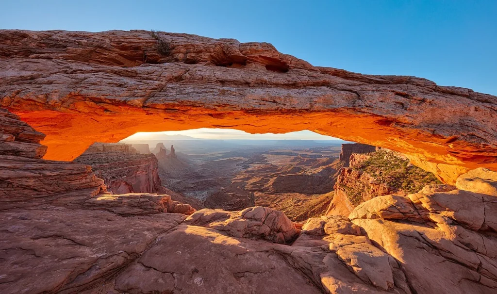
Photo: Mesa Arch at sunrise, August 11, 2016, by Thomas Wolf, www.foto-tw.de / Wikimedia Commons, CC BY-SA 3.0. Resized and converted to WebP, no crop or retouch; same license applies. Island in the Sky, not The Needles or The Maze.