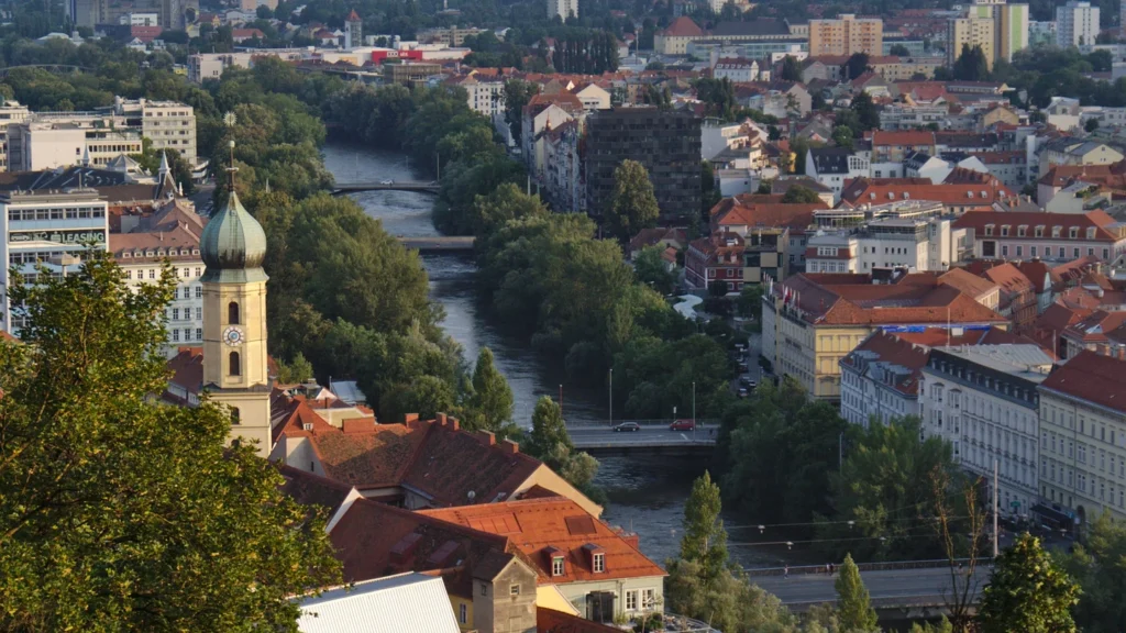
Graz, the capital of Styria, sits on the Mur River at the southeastern edge of the Alps. The old center grew near a crossing on the east bank, below the Schlossberg. South of that little hill, the valley opens out, and the built-up area goes beyond the city boundary.
Graz’s old center grew below the Schlossberg at a crossing of the Mur. The bridge drew trade to the lower town, while the hill gave the city a defensive position. Across the river, Lend and Gries developed on the west bank.
Start at the river: Find the city boundary on the map, see how the crossing shaped the center, or compare the city and wider region’s population.
Graz sits where the Mur Valley opens southward
Locate the city in the Mur Valley
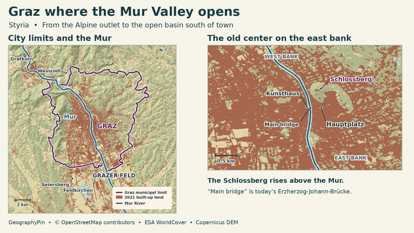
Graz is the capital of Styria in southeastern Austria. The Mur enters the city area from the north, near Weinzödl, where the valley comes out of the mountains. It crosses Graz and continues south through the Grazer Feld, a wider section of the valley. The old center sits at the foot of the Schlossberg on the east bank. Look beyond it on the map and you can see that the places sharing this valley are not all in the same municipality.
Graz is a municipality and a political district in its own right. Within it, the city has 17 local districts, including Innere Stadt, Lend and Gries. Seiersberg-Pirka and Feldkirchen bei Graz sit just beyond the southern side of the city and have their own municipal boundaries. Graz-Umgebung is the name of the surrounding administrative district, not a synonym for the Graz municipality or for the entire statistical city region.
Why old Graz grew between a crossing and a hill
Read both banks at the old crossing
The river mattered in two ways. It made a crossing valuable, and it limited how the oldest streets could spread on the east bank. The city’s history describes an early street market at a junction near the Mur crossing. Behind it, the ground rises at the Schlossberg. Market streets such as Sackstraße and those around Hauptplatz and Herrengasse developed closer to the lower ground, with the fortified hill above them.
The old city was not centered on one point. Lower down, traders had access to the crossing and market. Uphill, the early defenses occupied ground with a broader view and a steeper approach. The bridge then made it possible to grow beyond that initial strip. Crossing to the west brings you to the former Murvorstadt, the area where neighborhoods such as Lend and Gries developed. On today’s map the Kunsthaus sits on that bank, facing the historic center across the water.
The historic crossing and the bridge you see today are not the same physical structure. Graz’s municipal records describe rebuilding after ice and floods. The current bridge was known as Hauptbrücke and was renamed Erzherzog-Johann-Brücke in 2009. The old name still helps connect historical accounts to the spot, while the new one is the one to look for on most modern street maps.
Schlossberg and the wider landscape south of Graz
The Schlossberg is a distinct rise on the east bank, not a foothill that fills the city. The Clock Tower, or Uhrturm, stands above the old center. The hill makes a sharp local contrast with the flatter strip around Hauptplatz. Beyond central Graz, the larger contrast is between the hills flanking the basin and the broader, lower land continuing down the Mur.
Styria’s physical landscape inventory uses Grazer Feld for the stretch from the Mur’s Alpine outlet near Weinzödl to the narrowing near Wildon farther south. Graz occupies its northern part. That makes the city a useful place to see the transition from a valley constrained by hills to a wider valley floor at the southeastern edge of the Alps. The river is continuous between them; the width and amount of buildable flat land change.
At that larger scale, part of the continuous cityscape spreads beyond the legal city line. The mapped built-up layer also includes industrial yards and major paved areas. It shows where surfaces are developed, not whether people live or commute there. The valleys help explain where development clusters without determining the municipal boundary.
Which Graz population should you use?
Distinguish the city and wider region
Statistics Austria puts Graz municipality at 306,971 residents on January 1, 2026. To compare the city with a broader area on identical dates, use the agency’s January 2021 municipal figures alongside its 2021 urban–rural typology. The statistical Stadtregion, or city region, includes an urban core of several municipalities and a wider zone tied to that core by measures including work commuting and access.
| Boundary | What it covers | Residents |
|---|---|---|
| Graz municipality | The city proper | 291,134 |
| City-region core | 13 municipalities, including Graz | 356,618 |
| Outer city-region zone | 45 additional municipalities | 145,992 |
| Entire city region | 58 municipalities across the two zones | 502,610 |
The city is included in the core and should not be added again. The region includes places well beyond the contiguous built-up area. A figure labeled simply “Graz metro” may use a different definition, such as a different commuting threshold or grouping of administrative districts. It will not necessarily match this number even if both are correctly sourced.
Frequently Asked Questions
Is Schloss Eggenberg the castle on the Schlossberg?
No. Schloss Eggenberg is a palace west of the city center. The Schlossberg is the hill above the old center on the east bank. The UNESCO listing includes both the historic center and Schloss Eggenberg, but they are separate places.
What do right and left bank mean on the Mur?
Bank names are determined while facing downstream. Through central Graz, that means facing generally south: the Schlossberg is on the left or east bank and the Kunsthaus is on the right or west bank.
How much of Graz is in the World Heritage property?
UNESCO lists 91.08 hectares after an approved 2026 boundary adjustment, with a separately defined 271.73-hectare buffer zone. It does not designate the entire municipality, nor is the buffer additional inscribed property.
What Did We Learn Today?
Graz grew around a Mur crossing, with markets on the east bank below the Schlossberg and later neighborhoods across the water. The Mur then continues through a wider valley floor that the city shares with other municipalities. The same strip of buildings can cross a city boundary, which is why Graz’s resident count and the wider city-region figure describe different areas.
Sources & Data Notes
- City of Graz, official geography and city districts; Statistics Austria, Graz municipal population and administrative unit, January 1, 2026. Statistics Austria January 1 series (total sheet, municipality 60101) gives the city’s 2021 comparison figure. Urban–Rural Typology, Table 8 supplies the matching 2021 boundaries and core/outer-zone rows (Graz UZ1002). No Eurostat/OECD commuting-area count is implied.
- Province of Styria, Grazer Feld landscape inventory, for Weinzödl, the Alpine outlet and the reach to Wildon. City of Graz history and historical river crossings and Murvorstadt. Municipal Lend guide, for bridge rebuilding and 2009 name, and the city’s Kunsthaus account, for opposite banks.
- UNESCO, City of Graz – Historic Centre and Schloss Eggenberg and approved 2026 minor boundary modification. Article map shows place locators, not the World Heritage property, its buffer zone or the statistical city region.
- Map: GeographyPin. City limit and river from relation 34719 and relation 59792, © OpenStreetMap contributors. Built-up land and background water classification from ESA WorldCover 2021 v200, CC BY 4.0; © ESA WorldCover project 2021 / Contains modified Copernicus Sentinel data (2021) processed by ESA WorldCover consortium. Relief produced using Copernicus WorldDEM-30 © DLR e.V. 2010-2014 and © Airbus Defence and Space GmbH 2014-2018 provided under COPERNICUS by the European Union and ESA; all rights reserved.
- Featured photo: Mur river in Graz, Harpsz, June 29, 2018; crop, resize and WebP conversion. The adapted photograph remains under CC BY-SA 4.0.