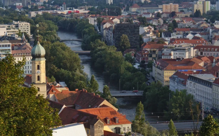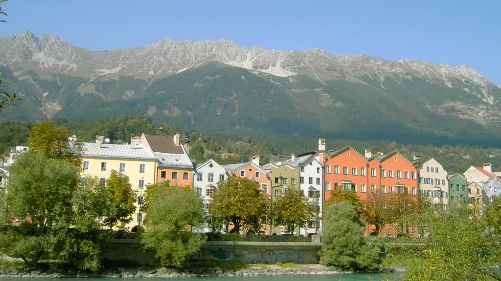
Innsbruck sits in the Inn Valley in western Austria, with steep mountains close to its buildings. Most of the city spreads east and west along the river. The way south to Italy turns into a different valley here, while the built-up land continues into towns on either side of Innsbruck’s boundaries.
Innsbruck, the capital of Tyrol, sits where routes along the Inn Valley meet the way south through the Wipptal. That second valley leads to the Brenner Pass on the Italian border. The mountains funnel settlement and transport into those two corridors.
Follow the valleys: See where the city fits between the mountains, then compare the road and railway to Brenner and the city and regional population counts.
Innsbruck stretches along the floor of the Inn Valley
Find the city on the Inn Valley floor
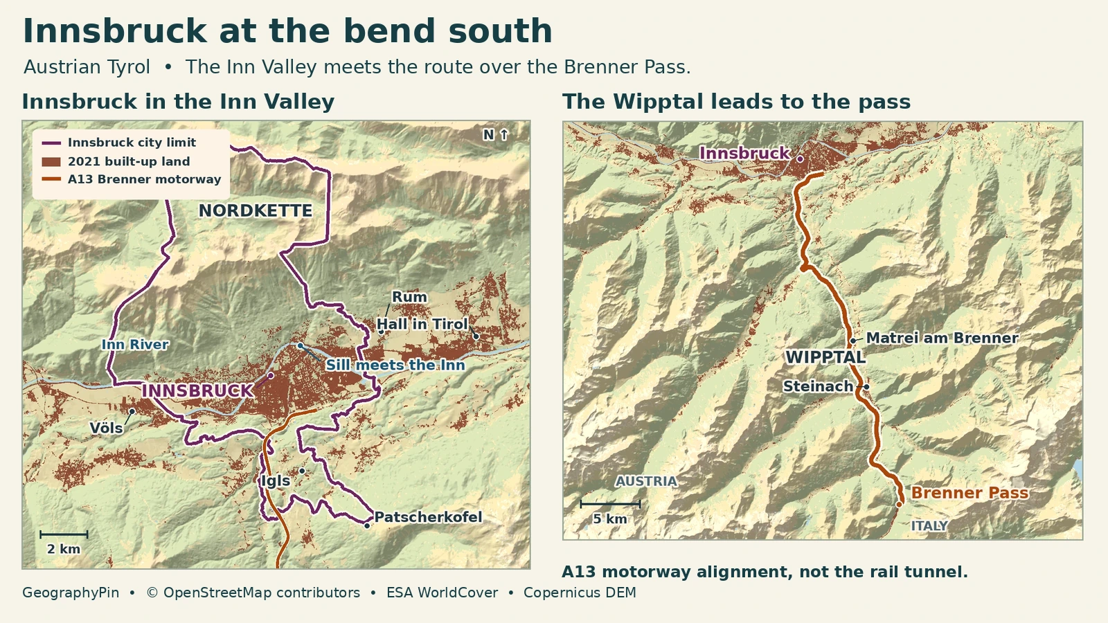
Innsbruck is the capital of Tyrol in western Austria. The Inn runs through the city from west to east before bending northeast toward Hall in Tirol. The Nordkette rises on the north side of the valley, and the Patscherkofel massif is to the south. Buildings follow the flatter land between them. The municipal outline does not: it extends north into the Karwendel mountains and south beyond the main valley floor.
That is why a map of buildings and a map of jurisdiction look different. Hötting sits on the north side of the Inn, while Wilten and Pradl grew south of the river. Igls is also in Innsbruck, though it sits on higher ground south of the center and is separated from it by slopes and other open land. Völs and Rum, in the same valley immediately west and east of the city, are separate municipalities. Innsbruck’s charter gives the city its own district authority; the surrounding district called Innsbruck-Land is not its municipality.
The Inn, the Sill and the slopes above them
The Inn makes the east–west layout of the city easy to read. The historic center, the neighborhood across the river at Mariahilf and later settlements farther along the valley occupy different parts of the same low corridor. The Sill comes north out of the Wipptal, enters Innsbruck from the south and joins the Inn at the Sillzwickel east of the old town. The confluence is not where the road to the pass branches: that happens farther south and upstream on the Sill side of the city.
The urban pattern is especially clear on the surrounding slopes. The Nordkette is part of the Karwendel range, directly above the northern neighborhoods. On the other side, places like Igls occupy a bench above the floor of the Inn Valley, not a continuation of the city’s flat riverside streets. A short horizontal distance on a street map can therefore conceal a considerable climb. The map’s relief helps separate the river corridor, the higher settlements and the steep slopes above them.
Land cover also needs a careful reading. The colored patches show built-up surfaces observed in 2021, not housing density. Roads, industrial roofs and other developed land can contribute to the mapped footprint. This is why a line measuring how much of the valley looks developed still cannot substitute for a count of people who live there.
Why the route to Italy turns south here
Follow the Sill valley toward Brenner
The Inn Valley gives transport a corridor across central Tyrol: west toward the upper valley and east toward Hall and the lower valley. At Innsbruck the route toward Italy leaves the Inn Valley and turns south along the Sill through the Wipptal. The Wipptal runs south through the mountains toward the Brenner Pass, about 1,370 meters (4,495 feet) above sea level on the Austria–Italy boundary. On its Austrian side, the Sill drains north toward Innsbruck. The road and railway climb the other way, toward the pass.
The A12 is the motorway along the Inn Valley. The A13 branches onto the Brenner approach on the city’s southern side; its two brief connections with the A12 should not be confused with two roads over the pass. The relief explains their shape: once south of the city, the main A13 follows the Wipptal corridor rather than cutting straight across the ranges. Places such as Matrei am Brenner and Steinach further up the valley help locate that turn on a wider map.
The existing railway also climbs the Wipptal, but follows its own line and gradients. ÖBB lists services from Innsbruck to Brenner on this railway. The Brenner Base Tunnel is a separate construction project designed to take trains below the mountain at a much gentler gradient, between Innsbruck and Fortezza in Italy. In November 2026 the project still lists active construction. A map that draws a tunnel as though it is already carrying the regular service would give the wrong picture of the current crossing.
Which population belongs to Innsbruck?
What each population figure counts
For the municipality, Austria’s official annual population series gives 132,820 residents on January 1, 2026. That is not a headcount of everyone at work in Innsbruck on an ordinary day. The surrounding towns have their own resident counts even when many people travel into the city regularly.
Statistics Austria’s Stadtregion, or city region, is a different unit. Its Innsbruck definition combines an urban core of several municipalities with an outer area identified by its ties to that core, using criteria that include work commuting. The agency published a matched 2021 breakdown: the city proper is only one part of the 14-municipality core. The outer zone contains 45 more municipalities. Those settlements do not form one blanket of buildings across the mountains.
| Area | What it counts | Residents |
|---|---|---|
| Innsbruck municipality | One city municipality | 131,059 |
| City-region core | 14 municipalities, including Innsbruck | 199,604 |
| Outer zone | 45 further municipalities | 82,566 |
| Entire city region | Core and outer zone (59 municipalities) | 282,170 |
Do not add the municipality to the region total; it is already inside the core. If you see a different “metro population,” check whether the publisher is using the same Austrian city-region definition or an international functional-area method. The lines and the dates can both change.
Frequently Asked Questions
Is Innsbruck-Land another name for metropolitan Innsbruck?
No. Innsbruck-Land is an administrative district, while the city has its own district authority. Statistics Austria’s much wider city region is a statistical unit defined separately from the district.
Where did the Olympic Village fit into a city with so little flat land?
Innsbruck placed housing for the 1964 and 1976 Winter Games in the eastern part of the valley. That housing became part of the present-day Olympisches Dorf district, rather than a self-contained resort up in the mountains.
Why do some train maps say Brennero/Brenner?
Brennero is the Italian name and Brenner is the German name. ÖBB prints both names together for the same border station; they are not successive stops.
What Did We Learn Today?
Innsbruck’s streets spread mostly along the Inn between steep mountains. The Sill and Wipptal mark a way through those mountains toward Brenner and Italy. The same valleys bring together settlements on both sides of the city boundary, which is why the municipality, built-up valley and statistical city region are three different things.
Sources & Data Notes
- Innsbruck city charter, which includes Igls and confirms that city territory and political district coincide; official Innsbruck–Völs–Rum study, for the topography and east–west settlement pattern; city guide to the Sill confluence.
- Statistics Austria, January 1 municipal population series (total sheet, municipality 70101); Urban–Rural Typology, Table 8, Innsbruck UZ1006, for the 2021 core and outer area. No Eurostat commuting-zone count is implied. The 2026 current city count is separate from the matched 2021 comparison.
- Province of Tyrol, Wipptal and the two transport corridors; Austrian transport ministry, A13 road classification; ÖBB, existing Tyrol railway network and bilingual Brenner station name. BBT SE, pass elevation and the new tunnel and construction progress, checked November 21, 2026.
- City of Innsbruck, Olympic Village development, and district histories.
- Map: GeographyPin. OpenStreetMap relations 4835169 (city) and 59777 (A13), © OpenStreetMap contributors. Built-up land and water from ESA WorldCover 2021 v200, CC BY 4.0; © ESA WorldCover project 2021 / Contains modified Copernicus Sentinel data (2021) processed by ESA WorldCover consortium. Relief produced using Copernicus WorldDEM-30 © DLR e.V. 2010-2014 and © Airbus Defence and Space GmbH 2014-2018 provided under COPERNICUS by the European Union and ESA; all rights reserved.
- Featured photo: Nordkette vom Innsbrucker Marktplatz gesehen, Weissbier1328, autumn 2005; cropped, resized and converted to WebP. The adapted photograph remains under CC BY-SA 3.0.