On a map of Namibia, the Atlantic and the Great Escarpment frame a long strip of dry land. Look more closely and the Namib is not one continuous dune field. The coast, the central sand sea and the inland slope each show a different side of the desert.
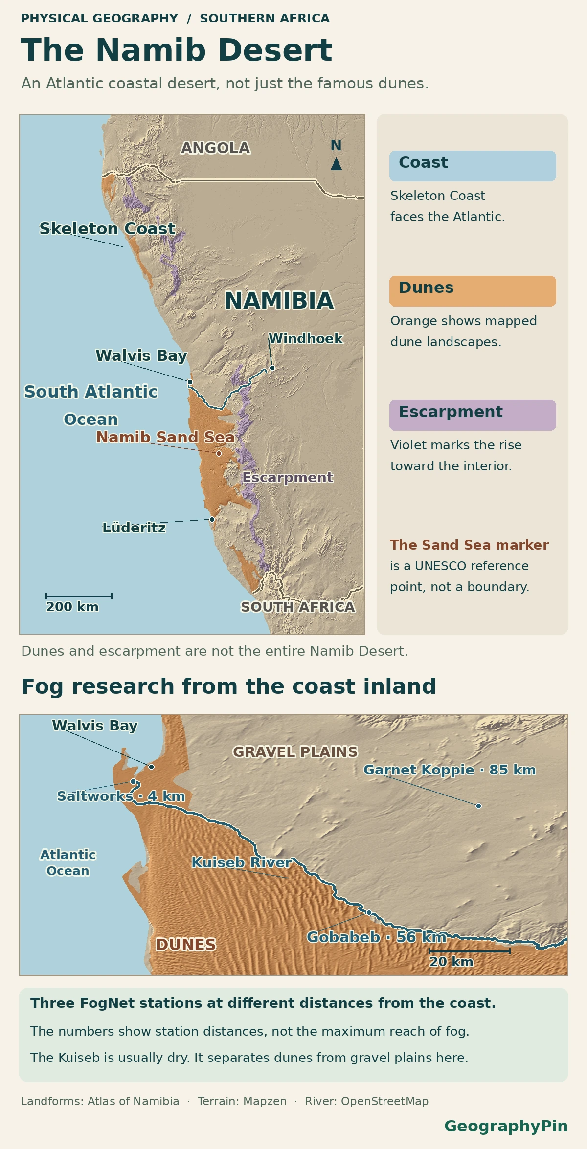
The Namib Desert lies along southwestern Africa’s Atlantic coast, mostly in Namibia, with the Great Escarpment inland. The Skeleton Coast is its northern Namibian coastal section, and the Namib Sand Sea is a central dune region. The World Heritage property protects part of that dune landscape, not the entire desert.
How to use this article: Locate the Skeleton Coast between named rivers, compare dunes and gravel plains at the Kuiseb or see what fog measurements tell us.
Locate the desert between the ocean and the high ground
Start at the Atlantic and look inland. In central Namibia, the Geological Survey’s terrain study describes the Namib as occupying a low, gently rising coastal plain beneath the much steeper Great Escarpment. The Atlantic coast is a visible western edge. The inland edge is less exact: the steep terrain is a useful landmark, but dryland vegetation and the frequency of fog do not change at one surveyed line.
The Skeleton Coast is the northern comparison
Use the Ugab and Kunene as park landmarks
On a map of northern Namibia, the environment ministry puts Skeleton Coast Park between the Ugab River in the south and the Kunene in the north. Its shore is only one section of the longer Namib coast. The park includes dunes, but also gravel, rocky canyons and dry riverbeds. South of the Ugab, the ministry calls the neighboring protected area Dorob National Park.
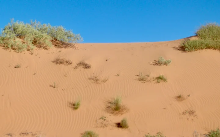
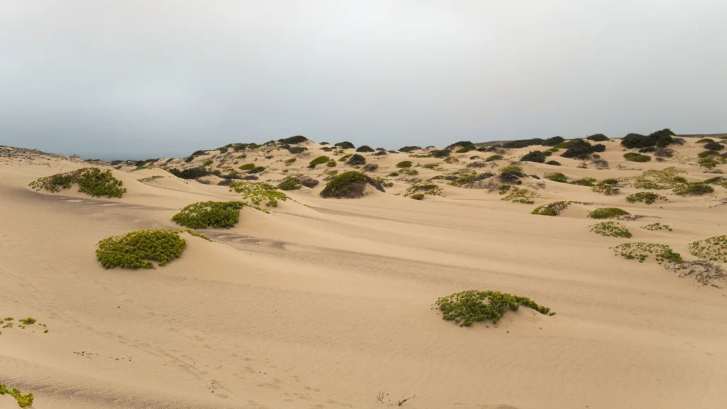
“Skeleton Coast” is a name for this coastal landscape as well as part of the formal park name. The photograph shows dunes and sparse shrubs in the northern park. It is not a photograph of the separate World Heritage property farther south.
The central sand sea is one part of the Namib
Find where gravel plains meet dunes at the Kuiseb
The central Namib fog field study describes gravel plains north of the Kuiseb River and dunes of the Namib Sand Sea south of it. That contrast makes the river useful for reading the map, not a boundary for the entire desert. The Namib-Naukluft Park account places the Gobabeb research station on its banks.
There is a reason to look south beyond the dune field itself. Mineral tracing by Vermeesch and colleagues identified the Orange River as the main source of sand in their samples. The World Heritage account describes the sequence: rivers carry sediment to the coast, ocean currents move it alongshore and wind carries beach sand onshore into the dunes. Research at Narabeb published in 2024 also describes a stronger contribution farther east from rivers draining the Great Escarpment. An important source of sand is not the same as the sole source.
What changes inland toward the escarpment
Fog puts water on surfaces even when rain is scarce
Fog droplets can wet sand and rock without measurable rain. One Namib field study logged wet conditions in and around translucent quartz rocks used by microbes. At its two study sites, five individual fog events supplied an average of about six hours of shallow moisture by the team’s humidity measure. The rainfall event in the comparison wetted more deeply and lasted longer. Fog gave these microbes a recurrent source of moisture; it was not a substitute for rain at every depth.
The cold offshore Benguela system helps favor coastal fog, but water-isotope measurements at Gobabeb show that some of the sampled fog also formed from local moisture. In the map close-up, the three sample locations sit 2 mi (4 km), 35 mi (56 km) and 53 mi (85 km) from the coast, as reported in Table 1 of a 2026 FogNet study. Those distances locate Saltworks, Gobabeb and Garnet Koppie. They are not the maximum distance fog can travel or a line where the desert ends.
At Garnet Koppie, 53 miles (85 kilometers) inland, ground instruments indicated fog during the night of September 27–28, 2017. The study used that event to compare surface observations with satellite-based estimates of cloud-base height, not to fix the inland limit of fog.
A physical desert is not a protected-area boundary
UNESCO’s 2013 map of the inscribed Namib Sand Sea covers 3,077,700 hectares (30,777 km²), plus a separately recorded buffer of 899,500 hectares. The property is wholly within Namib-Naukluft Park. The two protection boundaries are not interchangeable, and neither is a measurement of the full desert.
The wider desert continues beyond the national map in geographic accounts. A Namib biome synthesis, for example, follows the coastal belt from Angola to just south of the Orange River near the border with South Africa. That is a description of a biome, not the jurisdiction of the Skeleton Coast park or a UNESCO extension. On the inland side, use the escarpment as a terrain reference and treat the transition as gradual rather than giving it a false legal edge.
| What you are locating | What fixes its extent? | Where to look first |
|---|---|---|
| Coastal desert | Terrain, climate and ecology; different definitions can draw different edges | Low dry ground west of the Great Escarpment |
| Skeleton Coast Park | National protection boundary | Northern Namibian coast between the Ugab and Kunene rivers |
| Namib Sand Sea World Heritage property | Inscribed boundary, with its buffer recorded separately | Central Namibia, inside Namib-Naukluft Park |
Frequently Asked Questions
Does the Kunene River mark the end of the Namib Desert?
No. It marks the northern edge of Namibia’s Skeleton Coast Park in this coastal setting. Across the river in Angola is Iona National Park, which together with Skeleton Coast forms a transfrontier conservation area. The dry coastal landscape does not stop at the national border.
Does a million-year estimate mean every dune is a million years old?
No. The 2010 isotope study estimated how long sand had resided within the dune system, not when each dune took its current shape. Wind can rework the same grains many times.
What is actually measured at Gobabeb?
A 2014–2023 dataset records stable isotopes in separate samples of rain, fog and dew from the research station. The sample measurements help distinguish sources of moisture. They do not estimate one annual fog value for the entire Namib.
What Did We Learn Today?
The Namib stretches along the Atlantic below the Great Escarpment. Skeleton Coast Park and the Namib Sand Sea World Heritage property cover separate parts of that wider landscape. Fog can sustain organisms on the ground even where rain is scarce, but neither a fog-monitoring transect nor a protected-area map defines the desert’s whole edge.
Sources & Data Notes
Namibia’s environment ministry identifies the national parks, and UNESCO supplies the inscribed 2013 World Heritage map and separately reported property and buffer areas. The terrain comparison uses geological field work; the fog observations concern measured sites near the Kuiseb and Gobabeb and do not establish a geographic limit.
Photo: Skeleton Coast dunes by Daniel Kraft, May 27, 2019, CC BY-SA 3.0 (cropped and resized, same license). Map data: Natural Earth, Mapzen Terrain Tiles, Atlas of Namibia Team, Namibia Nature Foundation (CC BY 4.0; selected landforms, color and framing adapted), OpenStreetMap contributors (ODbL).