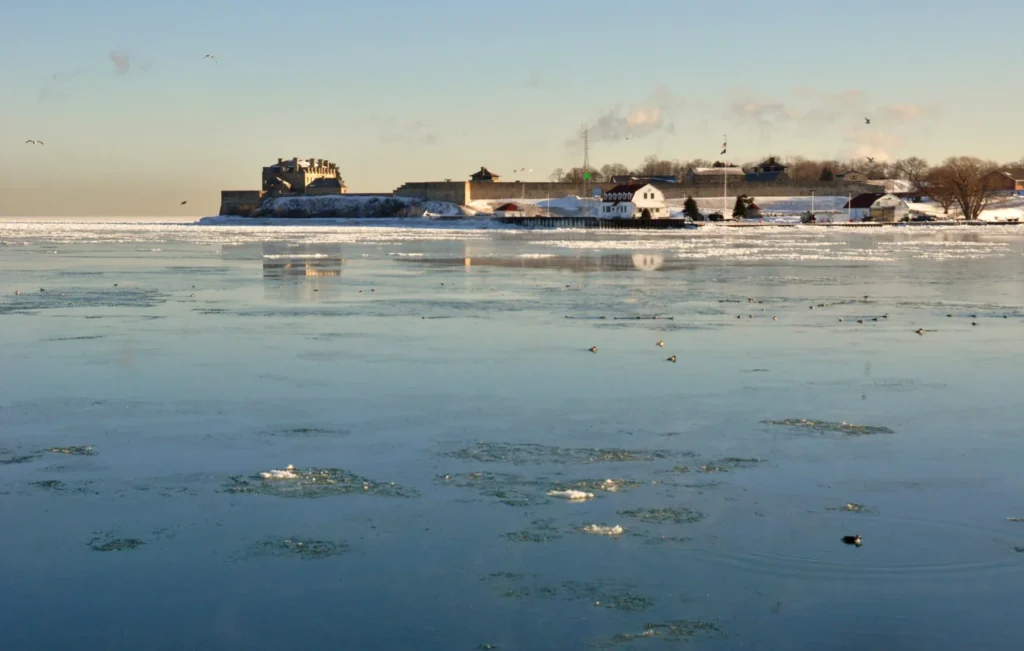
At Niagara-on-the-Lake, the Niagara River opens into Lake Ontario. The familiar waterfall is farther upstream, in a different municipality. Follow the river north and the town’s name becomes a guide to its geography.
Niagara-on-the-Lake is downstream of the falls
Niagara-on-the-Lake is an Ontario town where the Niagara River flows into Lake Ontario, across the water from New York State.
Old Town is the historic centre on the Canadian side of the river mouth. Niagara Falls lies farther upstream, and the Ontario city of that name is a separate municipality.
How to use this article: See the river-mouth map, then check the river’s direction and the Old Town distinction.
Find the town at the north end of the river
Niagara-on-the-Lake occupies the northeastern corner of Ontario’s Niagara Peninsula. Put Lake Ontario above the map and the lower Niagara River to the right. Old Town sits near the corner where they meet, with the New York shore just across the river. St. Catharines lies to the west and Niagara Falls to the south.
Start at the Lake Ontario end
The Canadian Geographical Names Database records Niagara-on-the-Lake as the official hyphenated name for the town. Its reference point is for the municipality, not a pin for the waterfront or the mouth. For the historic centre, use Old Town and then look for streets or landmarks on the detailed view.
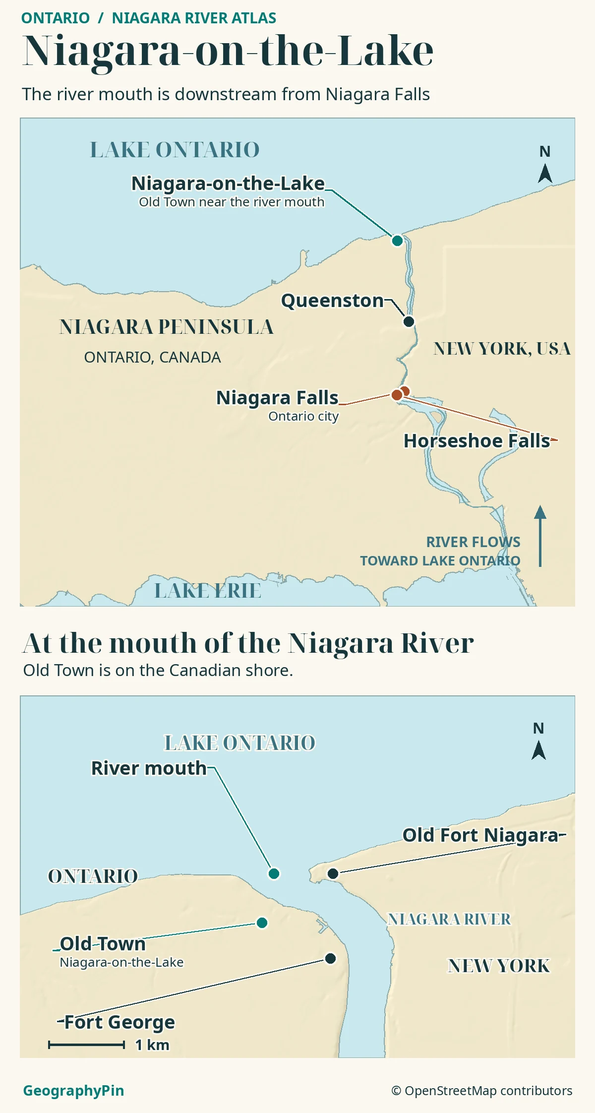
Where the Niagara River meets Lake Ontario
From Lake Erie downstream to Lake Ontario
The Niagara River is the natural outlet of Lake Erie and flows into Lake Ontario. The International Joint Commission describes it as about 36 miles (58 km) long. That is the full waterway between lakes, not a road distance from Old Town to the falls. At Niagara-on-the-Lake you are looking at the river’s mouth, not Lake Ontario’s own outlet.
The lakes differ in elevation by roughly 326 feet (99 m), according to the commission, with about half of that drop at the falls. Continuing downstream takes you through the gorge toward Queenston and then through the lower river toward the lake. At Old Town, the low banks open out onto Lake Ontario.
Old Town is only part of the municipality
Use Old Town for the historic centre
Old Town is the historic settlement near the mouth, not another name for every place in the modern municipality. Niagara-on-the-Lake also includes Queenston, St. Davids, Virgil and Glendale. The town outlines its five settlement areas separately. The historic core and the larger town boundary answer different questions, so a destination pin depends on which one you mean.
Fort George is on the Ontario shore upriver from the mouth. Its position helped guard activity on the river and protect the Navy Hall supply site. Fort Niagara stands across the river on the New York side, at the mouth. Their positions show why the river mattered for movement through the Great Lakes and why similar fort names are not directions to the same side.
From the Niagara Escarpment to the lakeshore
The Niagara Peninsula is the broader land area between the lakes on the Ontario side. Its Niagara Escarpment is a long ridge and cliff line. The river cuts through that high ground in the gorge; Niagara Parks describes the falls retreating upstream from their former position near Queenston as they eroded the rock. The low shoreline at Old Town is downstream of that steep terrain.
Between the escarpment and Lake Ontario are gentler plains and slopes. The Ontario Wine Appellation Authority identifies the lake and river as influences that moderate temperatures in the wine-growing area. Water changes the local temperatures, while elevation and slope also matter. Neither a lake breeze nor a wine-region label makes the entire peninsula one flat or uniform landscape.
How to read three places called Niagara
Read the names at the scale of your question. Niagara River names the waterway between the lakes. Niagara Falls can mean the waterfalls or either of the separate cities beside them in Ontario and New York. Niagara-on-the-Lake names the Ontario municipality downstream, including Old Town at the lake end. Both Canadian municipalities belong to Niagara Region; one is not a neighbourhood of the other.
Canada and the United States meet along the waterway, but the shore itself is not the international boundary line. On a regional map the easiest way to tell the shores apart is to locate Old Town and the Ontario shore first, then find Fort Niagara and Youngstown across the lower river in New York.
Frequently Asked Questions
Why does a historical map call Old Town “Newark”?
Parks Canada uses Newark for the historical settlement that became Niagara-on-the-Lake. Use Niagara-on-the-Lake on modern maps; add Old Town to locate the historic core rather than the whole municipality.
Is Queenston part of Niagara-on-the-Lake even though it is upriver?
Yes. Queenston is one of the municipality’s settlement areas. It sits near the foot of the escarpment and the downstream end of the gorge, not at Old Town’s Lake Ontario waterfront.
Where does the water go after entering Lake Ontario?
Lake Ontario drains into the St. Lawrence River at the lake’s eastern end. The Niagara River is an inlet at the opposite end of the lake, so these are two separate places in the Great Lakes drainage system.
What Did We Learn Today?
The Niagara River leaves Lake Erie, passes the falls, and reaches Lake Ontario at Niagara-on-the-Lake. Old Town is the historic core at the river mouth, while Queenston and other settlements are part of the wider municipality. The river, the falls and the lakeshore town belong on the same regional map, but not at the same point.
Sources & Data Notes
The Canadian Geographical Names Database, Town of Niagara-on-the-Lake and Niagara Region’s plan establish the official name, settlements and municipal scope. The International Joint Commission’s Ice Boom report supplies the rounded river length and elevation figures; its St. Lawrence notes identify the outflow. See Niagara Parks’ geology guide, the Ontario Wine Appellation Authority, Parks Canada’s Fort George and historic landscape notes, and New York State Parks’ Fort Niagara map.
Map: GeographyPin; waterbodies, river and landmarks from OpenStreetMap contributors (ODbL) and shaded relief from Mapzen/AWS Terrain Tiles, retrieved November 20, 2026. The atlas locates places rather than surveying municipal or international boundaries.
The winter view across the mouth dates to February 2014. Photo by Mykola Swarnyk, CC BY-SA 3.0, resized and converted to WebP under the same license. Editorial responsibility: Zurab Koniashvili (Z.K. Atlas); AI tools assisted in preparation.
