In Montana’s Glacier National Park, the best entrance depends on which lake or viewpoint you want to reach. Going-to-the-Sun Road links the two sides only when the high section is open. A sightseeing plan that works in July can become two separate out-and-back drives in fall.
One mountain crossing, two ways in
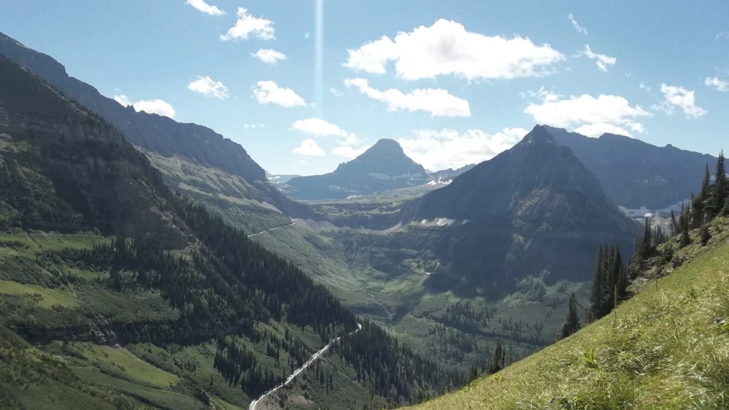
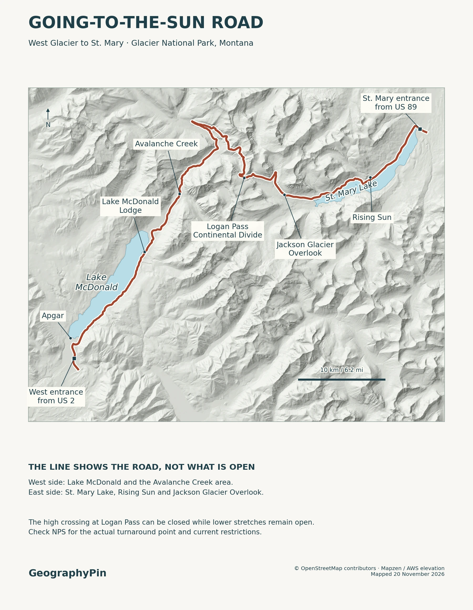
Going-to-the-Sun Road runs about 50 miles (80 km) across Glacier National Park in Montana. The route starts at West Glacier, passes Lake McDonald, crosses Logan Pass, and follows St. Mary Lake to the St. Mary Entrance.
If the alpine section is closed, choose the side that reaches your stop without crossing the pass.
How to use this article: Compare the entrances for a lake or a through-drive, check the walk from Logan Pass to Hidden Lake Overlook, or find the road status and the outside detour.
Choose West Glacier or St. Mary
The West Entrance is at West Glacier, off U.S. 2. It is the practical start for Apgar and Lake McDonald. The St. Mary Entrance, off U.S. 89, is the eastern entrance to this road. St. Mary is not the town of East Glacier Park, and a road into the Many Glacier or Two Medicine district does not join this scenic crossing inside the park.
Pick an entrance for the stop that matters most
| Your priority | Where to start | If the alpine road is closed |
|---|---|---|
| A lake and a short stop | West Glacier for the Lake McDonald shore; St. Mary for the east end of St. Mary Lake. | Look for the last open pullout or trailhead on that side. Return to the same entrance. |
| Logan Pass and a full drive across the park | Either entrance when the entire road is open. Logan Pass is 32 miles (52 km) from the west entrance and 18 miles (29 km) from the east. | Do not count on crossing. Save the pass for another day and use U.S. 2 and U.S. 89 if you need to reach the other side. |
The 50-mile distance is the full scenic drive, not the mileage for a return trip or any walk. If you plan to drive across and return the same way, count a second traverse, and check whether delays, daylight and your stopping time still make that realistic.
Lake McDonald and Avalanche Creek
From West Glacier, Apgar is at the south end of Lake McDonald. The village and shoreline are not the same stop as Lake McDonald Lodge, farther along the road near the head of the lake. Think of Apgar as the early lake view and the lodge area as a separate lakeshore stop after following the lake’s southeast shore.
Beyond the lodge, the road follows the McDonald Creek valley toward Avalanche Creek. From the Avalanche Picnic Area, Trail of the Cedars is a 0.7-mile (1.1-km) accessible forest walk with boardwalk and paved sections. That is the short forest option. The route to Avalanche Lake branches off the cedar trail and takes you well beyond the short walk.
When weather allows, NPS typically plows the lower west side as far as the lodge area in winter. The lodge can be shut while its parking access remains open. Do not assume that the drive extends as far as Avalanche Creek or that a closed vehicle gate is open to people on foot or skis.
Logan Pass and the Continental Divide
At 6,646 feet (about 2,026 m), Logan Pass is the road’s high point and its crossing of the Continental Divide. The route climbs the western mountainside above McDonald Creek, then descends toward the St. Mary valley on the east. An open road means you can reach the pass from the open side; it does not guarantee a parking space or an open visitor center.
Hidden Lake Overlook is a walk, not a roadside pullout
From Logan Pass Visitor Center, Hidden Lake Overlook is 1.4 miles (2.3 km) one way, with about 460 feet (140 m) of gain. The lake shore is farther and considerably lower, so allow extra time for the climb back if you go beyond the overlook. Check the park’s trail map before counting on either hike, even if the road is open.
Parking fills quickly at the pass. If it is full, continue to a legal turnaround or choose another signed stop. The ticketed shuttle and timed-parking program NPS tested in summer 2026 is not a standing schedule for another year. Recheck the park’s setup for your dates if you are relying on a shuttle or planning a long hike.
St. Mary Lake and the eastern overlooks
Coming down from Logan Pass, Jackson Glacier Overlook is a roadside stop on the higher eastern section. It is a different destination from Wild Goose Island Overlook, a pullout beside St. Mary Lake with a view of the small island, water and mountain backdrop. You drive to each overlook’s parking area when its road is open; seeing the island does not require a hike or a boat.
Rising Sun is farther east along the lake, between Wild Goose Island Overlook and the St. Mary Entrance. The picnic area and lakeshore are distinct from the campground and motor inn across the road. In a partial opening, a drive from St. Mary toward Rising Sun may be possible even when Wild Goose Island Overlook or Jackson Glacier Overlook is beyond the closure. Read the named closure limits before picking an east-side stop.
For a walk rather than a pullout, Sunrift Gorge is about 200 feet (61 m) from its own roadside pullout. The route to St. Mary Falls starts elsewhere and is longer. Use the named trailhead and its current status rather than reading these stops as a single lakeshore walk.
What a partial road opening changes
Check road segments before trusting a through-route
On the morning you travel, use the NPS road and trail status map and click the exact road segment. The NPS park map is for locations; it cannot tell you whether the gate or trail is open today. For highways around the park, use the Montana Department of Transportation road reports.
November 20, 2026 snapshot: the NPS road layer showed the alpine crossing closed for winter weather, from near Avalanche Creek on the west to near Rising Sun on the east. The lower road segments from each entrance toward those areas showed open; those lines do not establish whether an adjoining lot, trail or service was open. Check the latest map before using either approach.
Full opening normally comes around late June or early July, not on a fixed date. During a partial opening, pick the entrance on the same side of the barrier as your stop. For a crossing between gateway towns when the pass is shut, NPS lists the U.S. 2 and U.S. 89 route at about 90 miles (145 km). It goes around the park and does not take you to Logan Pass.
Frequently Asked Questions
Can I drive Going-to-the-Sun Road in a large RV or with a trailer?
NPS prohibits vehicles and vehicle combinations longer than 21 feet (6.4 m), bumpers included, or wider than 8 feet (2.4 m), mirrors included, between Avalanche Creek and Rising Sun. Vehicles over 10 feet (about 3 m) tall may also have trouble with rock overhangs west of Logan Pass. Measure the full combination before driving to the park.
Does no vehicle reservation mean I can enter without a park pass?
No. The park did not require a vehicle reservation in 2026, but admission rules still applied. A park entrance pass is separate from a vehicle-entry reservation, a shuttle ticket and a parking permit. Check the park’s fee and reservation pages for your visit year.
Can I fill up with fuel along the scenic road?
No. NPS says there are no fueling stations inside Glacier National Park. Fill up outside the park, especially if the drive might turn into an out-and-back or a longer trip via U.S. 2 and U.S. 89.
What Did We Learn Today?
Start at West Glacier for Lake McDonald or St. Mary for the eastern lake. Logan Pass joins them when the high road is open; otherwise use the park map to choose a stop on your side of the closure. If you must get from one gateway town to the other, check the separate highway route.
Sources & Data Notes
The NPS park maps, route distances and seasonal overview, NPS driving distances and Glacier park districts establish the stops, entrances and distances. The November 20 road snapshot came from the road and trail status map; use that map and Montana highway reports for changing conditions. NPS covers foot access and distinct stops in its Lake McDonald Valley accessibility guide, St. Mary and Logan Pass trail distances, park winter access, Wild Goose Island Overlook, Rising Sun and Logan Pass guides. See its dated 2026 shuttle and parking update, Glacier entrance and fee rules and vehicle limits and fuel guidance for separate operating and entry rules. Metric values are rounded. Road photograph: Mountain walrus (CC BY-SA 3.0), cropped and converted to WebP under the same license. Editorial responsibility: Zurab Koniashvili (Z.K. Atlas); AI tools assisted in preparation.
Map: GeographyPin; road and site geometry from OpenStreetMap contributors (ODbL) and relief from Mapzen/AWS. The map does not show current road access, winter plowing or trail permission.