Acadia’s carriage roads are a second network alongside the roads you drive on Mount Desert Island. The numbered wooden posts tell you where gravel routes meet. Choose the right parking area before trying to follow those signs around a pond or lake.
Choose the lot first, then follow the numbered posts
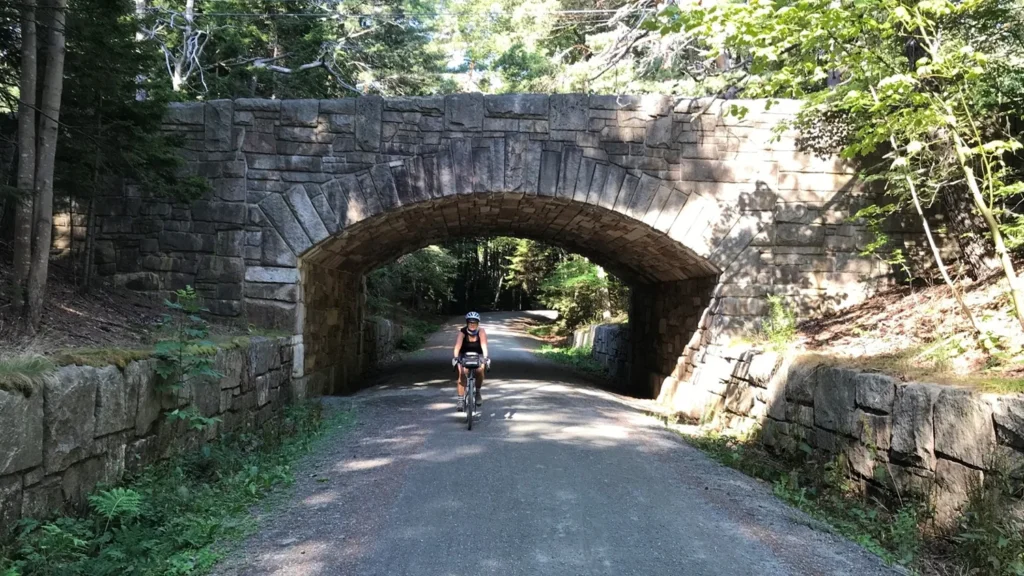
Acadia’s carriage roads are gravel routes for walking and cycling, separate from the motor roads.
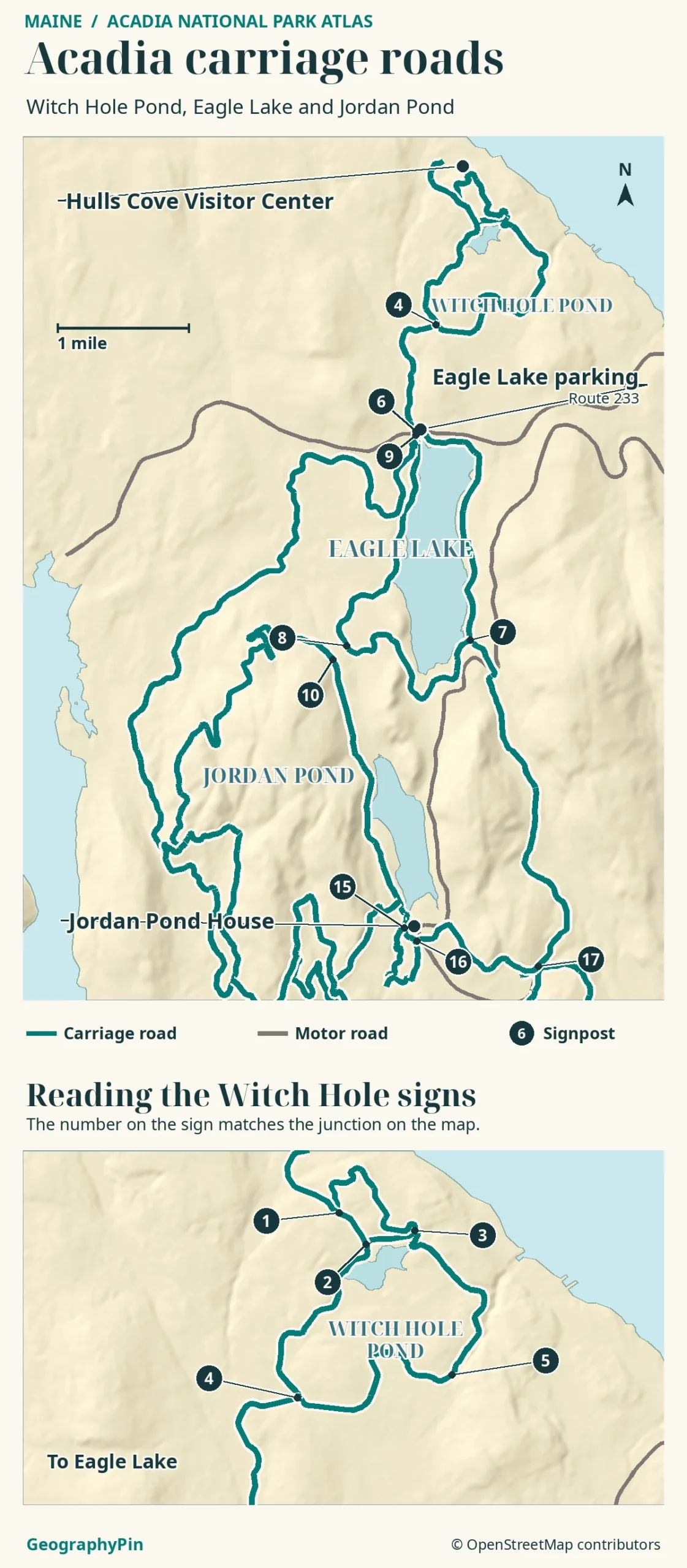
Start at Hulls Cove for Witch Hole Pond, at the Route 233 entrance for Eagle Lake, or near Jordan Pond House for the southern network. Match the numbered posts to junctions on the park’s carriage-road map.
How to use this article: Start with the access comparison, then see the junction-number example and locate the Jordan Pond House turnoff.
Pick a carriage-road entrance on Mount Desert Island
The park describes about 45 miles (72 km) of historic carriage roads. They run through the east side of Mount Desert Island, near Bar Harbor, with routes between woods, lakes and stone bridges. These roads do not carry regular motor traffic; Park Loop Road and Maine Route 233 are separate paved approaches, not parts of a carriage-road loop.
Match your starting point to the outing
| If you want | Start at | What the map means |
|---|---|---|
| Wooded ponds from the visitor center | Hulls Cove Visitor Center, then the connector toward junction 1 | The connector is steep. The named 4.7-mile loop begins at the numbered junction. |
| A full ride around Eagle Lake | Eagle Lake carriage-road parking on ME 233 | Junction 6 anchors the 5.9-mile lake loop. Allow for a hill near its southwest end. |
| A short outing near Jordan Pond House | Jordan Pond parking near the house | Use the signed connector near junction 15. You do not have to ride the full carriage-road loop. |
Witch Hole Pond from Hulls Cove
Witch Hole Pond is the northern option. At Hulls Cove Visitor Center, take the link from the parking area toward junction 1. NPS warns this approach is steep and tells riders to dismount. The difficulty of that short link can differ from the grade on the pond loop itself.
Match the numbered post to the map
The numbers identify intersections, not mileposts. For example, NPS describes the 4.7-mile (7.6-km) Witch Hole Pond Loop as 1 → 2 → 4 → 5 → 3 → 2 → 1. At junction 2 on the way out, take the branch toward 4 if following that order. You come back to junction 2 from 3 before returning to 1.
The smaller distance printed between two junctions on the official map is the length of that segment, not the distance from your car. Add the parking connector if you start off the loop, and count it again if you go back the same way. NPS also describes a different approach toward Witch Hole from the Eagle Lake parking area, roughly 5.3 miles (8.5 km) round trip; it is not another measurement of the named loop from junction 1.
Eagle Lake from Route 233
Eagle Lake has a practical access point at the carriage-road parking lot on the north side of Maine Route 233. The carriage road then passes below the paved road at the stone bridge. The park also identifies the boat-ramp area on the south side as an access option, rather than a second point on the lake loop itself.
The official Eagle Lake Loop follows 6 → 9 → 8 → 7 → 6 for 5.9 miles (9.5 km). The north and east shores are generally easier going; the west and south sides have more grade change, with a high point near junction 8. At 8, roads also branch toward other loops, so look for your next number instead of simply following the widest path.
Jordan Pond House and the longer carriage loop
Jordan Pond lies south of Eagle Lake. In the normal driving season, Jordan Pond House and its nearby parking are accessible from the two-way section of Park Loop Road. From that parking area you can reach the pond’s hiking paths or the carriage roads, but the two options are not interchangeable.
Find the Jordan Pond House connector
Junction 15 is the useful branch for Jordan Pond House. The park’s 8.6-mile (13.8-km) Jordan Pond Carriage Road Loop is numbered 16 → 10 → 8 → 7 → 17 → 16. It runs along the west side of Jordan Pond and continues well beyond it toward other landforms. The shorter footpath around the pond is a hiking trail, not a bicycle shortcut back to the house.
When access changes with the seasons
Winter driving: NPS guidance checked November 20, 2026, lists the regular December 1 through April 14 motor closure for most of Park Loop Road. It identifies Jordan Pond Road from Seal Harbor as the winter driving approach to the Jordan Pond parking area. Do not assume the usual route from Hulls Cove or every lot remains available; weather can change access.
Carriage-road surfaces: The gravel roads can have snow, ice or groomed cross-country ski tracks; avoid walking or riding in groomed tracks. In the spring thaw, the park can close carriage roads to all users to prevent rutting and erosion. A winter driving closure and a spring carriage-road closure are different restrictions.
Frequently Asked Questions
Can I use any electric bike on a carriage road?
No. NPS permits Class 1 pedal-assist e-bikes where bicycles are allowed on the carriage roads, not Class 2 or Class 3. Bike access does not extend to hiking trails or private carriage roads. Check signs at the branch you intend to take.
Do all carriage roads allow horses?
No. The official user map shows horse restrictions on the Witch Hole and Eagle Lake routes, including a limited exception for the Eagle Lake connector between junctions 7 and 8. Consult the latest regulations and signs rather than relying on a gravel line alone.
Which map should I use on the morning of my visit?
Keep the NPS carriage-road user map for its numbered posts and mileages, and check Acadia Current Conditions for closures or maintenance. A posted gate or closure takes priority over a line on either map.
What Did We Learn Today?
Hulls Cove, Route 233 and Jordan Pond House lead into different parts of Acadia’s carriage-road network. Use the official junction numbers to choose your turns, and distinguish the mileage of an individual segment, a complete loop and the approach from parking. Seasonal closures can affect the paved approach or the carriage surface separately.
Sources & Data Notes
Junction numbering and route lengths: National Park Service Carriage Road User’s Map and the official guides for Witch Hole Pond, Eagle Lake and Jordan Pond. Distances are for these specific starts and routes, not road approaches or pond-shore walks.
Access checked November 20, 2026: NPS winter motor-road directions, cycling rules, current conditions and spring-thaw policy. See Jordan Pond access for the separate shoreline setting.
Atlas: GeographyPin cartography with OpenStreetMap contributors (ODbL), OSM land polygons and AWS Terrain Tiles. Check the park’s full map for every junction; this selection does not convey private-property limits or current closures.
Photo: Christie Anastasia / National Park Service, public-domain NPS material; resized and converted to WebP. AI tools assisted in preparation.