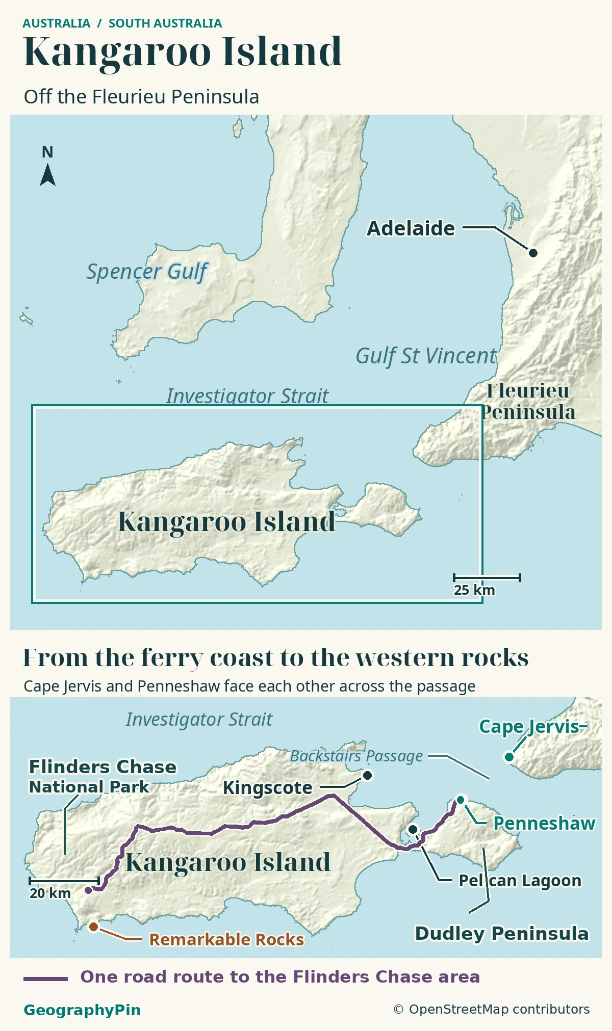
Kangaroo Island’s ferry arrives on its eastern side, while some of its best-known park landscapes lie far to the west. A map of the island and nearby mainland explains that separation before a list of attractions does.
Kangaroo Island’s position
Kangaroo Island lies off South Australia’s Fleurieu Peninsula. Backstairs Passage separates the mainland from its eastern Dudley Peninsula, where the ferry lands at Penneshaw. Flinders Chase is in the west, so reaching the island does not mean reaching its western park sites; an onward road journey must be planned.
How to use this article: Find the mainland and island, compare the ferry crossing with the whole journey, then locate Penneshaw in the east and Flinders Chase in the west.
The Island on a Regional Map
Separate the mainland from the island
Kangaroo Island lies off the coast of South Australia, southwest of Adelaide and beside the southern end of the Fleurieu Peninsula. South Australia is the Australian state, not a description of every place in the southern half of the country.
The island stretches broadly east to west. Its eastern arrival area and western park landscapes are different parts of a substantial landmass, not neighbouring stops around a small ferry harbour.
| Map anchor | Position | Planning significance |
|---|---|---|
| Cape Jervis | Mainland Fleurieu Peninsula. | SeaLink departure point, not an island town. |
| Penneshaw | Dudley Peninsula at Kangaroo Island’s eastern end. | The ferry arrival point; onward island transport starts here. |
| Flinders Chase | Western Kangaroo Island. | A separate road journey from the ferry landing. |
Backstairs Passage
The water crossing is only the first leg
Backstairs Passage separates eastern Kangaroo Island from the Fleurieu Peninsula. SeaLink operates its car-and-passenger ferry between Cape Jervis on the mainland and Penneshaw on the island. Neither endpoint is Adelaide, so an Adelaide-based journey also needs a mainland transfer.
The operator describes the crossing as approximately 45 minutes. That is sailing time, not the entire time from a mainland hotel to an island attraction. Add travel to the terminal, the required check-in, boarding and the onward journey after arrival.
Check current sailings and loading instructions directly with SeaLink for your date. A foot-passenger ticket delivers you to Penneshaw, not automatically to a western park. Arrange a vehicle, tour or other suitable onward transport rather than assuming a ferry ticket includes island-wide travel.
The passage also has a marine environment of its own. South Australia’s park information describes strong tidal currents and scoured seabed features in the area. Its apparent narrowness on a regional map should not be read as a promise of calm water or uninterrupted service.
Dudley Peninsula
Penneshaw belongs to the eastern island
Dudley Peninsula forms Kangaroo Island’s eastern end. Penneshaw, the ferry arrival town, is on this peninsula. It is not a separate island requiring another ferry to reach the main body of Kangaroo Island.
A narrow land connection, or isthmus, joins Dudley Peninsula to the larger western body of the island. The regional tourism authority describes that connection along the southern side of Pelican Lagoon. This is an important feature to preserve on a simplified map: the water around the peninsula does not cut all the way through it.
The peninsula has its own coastal scenery and settlements. Choosing an eastern-island visit can make sense when time is limited, because it reduces the distance between the arrival port and the places you want to see. That is an itinerary choice, not a claim that the rest of the island is inaccessible.
When booking accommodation, use the actual town or address rather than treating “Kangaroo Island” as one compact location. A place convenient for Penneshaw can be poorly placed for an early visit in the west, and the opposite can also be true.
Flinders Chase
Why western park sites are far from the ferry
The ferry lands at the eastern end because its route crosses Backstairs Passage to Penneshaw. Flinders Chase is in the west. The gap between them follows directly from the island’s shape and the positions of the mainland and park, not from a misleading ferry terminal name.
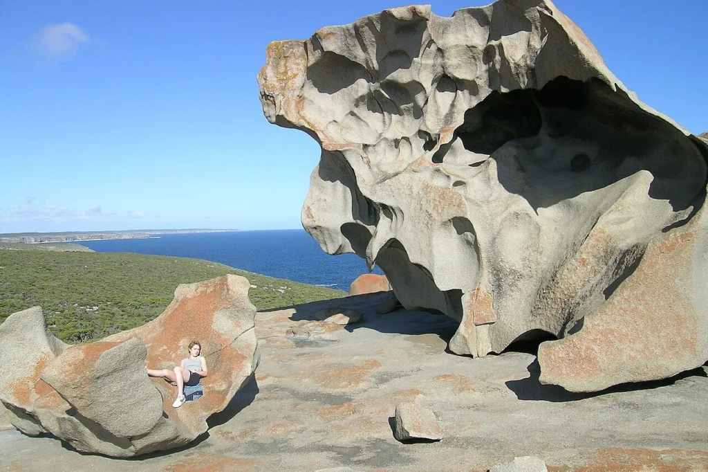
Remarkable Rocks is one of the western landscape’s best-known features. South Australia’s environment agency identifies it as granite boulders on a granite dome. It should not be described as a cluster of recent lava formations simply because it has rounded, sculptural shapes.
Park landmarks are also separate destinations within the western area. Reaching a visitor centre or park entrance is not the same as reaching every coastal viewpoint. Use the park’s current map to choose the actual stop, access road and walking approach.
South Australia’s parks service puts Flinders Chase about 81 miles (130 kilometers) and around 1½ hours by road from Penneshaw. That is an estimate for reaching the park, not the Remarkable Rocks car park. For a same-day trip, budget about three hours for the two drives, then add the drive to the rocks, time for the visit and a buffer. SeaLink asks you to check in at least 30 minutes before the return sailing. Its roughly 45-minute crossing is a separate part of the journey.
A shorter list of sites can be more realistic than an east-to-west checklist. If western parks are the priority, compare staying overnight with a tightly timed return trip, rather than assuming every highlighted point on the island map fits into one afternoon.
Shoreline and Jurisdiction in Context
An island outline is not a park boundary
Kangaroo Island is not one continuous national park. Towns, farming areas, visitor businesses and protected land occupy different parts of it. Flinders Chase is a particular protected area, not another name for the whole island.
Marine designations are a further layer. Encounter Marine Park includes waters associated with the northeastern island coast and Backstairs Passage. Its zones should not be inferred from the land shoreline or from a coloured tourism region.
The contrast between a peninsula, a passage and a park is useful here. Dudley Peninsula is a landform; Backstairs Passage is a waterway; Flinders Chase is a named park. They answer different questions about the same wider island landscape.
Frequently Asked Questions
Can I estimate driving time from a straight line across the island?
No. A straight line measures separation, not the route a vehicle can use. Compare the actual road journey between your chosen addresses, including park access roads, rather than the distance between two labels.
Can I visit Remarkable Rocks and return on the ferry the same day?
Possibly. Plan both road legs, the time to reach and see the rocks, and return check-in at Penneshaw. Confirm the sailing and arrange an on-island vehicle or tour before relying on a same-day return.
What Did We Learn Today?
The essential map relationship is mainland Cape Jervis, Backstairs Passage, eastern Penneshaw and western Flinders Chase. Dudley Peninsula remains connected to the main island, while park boundaries and marine zones are separate from the coastline. Plan the land journey as carefully as the ferry crossing.
Sources & Data Notes
- PlanSA: Kangaroo Island regional setting
- SeaLink: Kangaroo Island ferry route
- Kangaroo Island Tourism: regional geography fact sheet
- National Parks and Wildlife Service SA: Flinders Chase
- South Australian parks service: published Penneshaw to Flinders Chase estimate
- SeaLink: crossing time and minimum check-in
- Department for Environment and Water: Remarkable Rocks geology
- National Parks and Wildlife Service SA: Encounter Marine Park
Sources checked November 19, 2026. The approximately 45-minute crossing is the operator’s stated sailing duration, not total journey time or a guarantee for a particular departure. Park boundaries and marine zones require their own official mapping.
The purple road line uses the connected OpenStreetMap road graph through Hog Bay Road, Arranmore Road, Playford Highway, West End Highway and South Coast Road. It ends in the park approach area on South Coast Road, not at an exact park entrance or the Remarkable Rocks car park. Names were cross-checked against the South Australia regional plan (January 2026). This is one representative option, not a fastest route or a statement of road conditions.
Map: Original GeographyPin atlas using OpenStreetMap coastlines, © OpenStreetMap contributors, ODbL, November 2026; relief from Mapzen/AWS Terrain Tiles and underlying elevation sources. Port locations checked against SeaLink terminals. No sailing track or park boundary is drawn.
Photograph: Kangaroo Island — Remarkable Rocks, Roo72, March 2005, CC BY-SA 2.0 Germany. Resized and converted to WebP.