A trip sold as “Komodo” can mean a landing on Komodo Island, a ranger walk on Rinca or a viewpoint on Padar. These are separate islands. The distinction also matters to the dragons themselves: not every park island has the same population, and some wild dragons live outside the park.
Komodo lies between Sumbawa and Flores
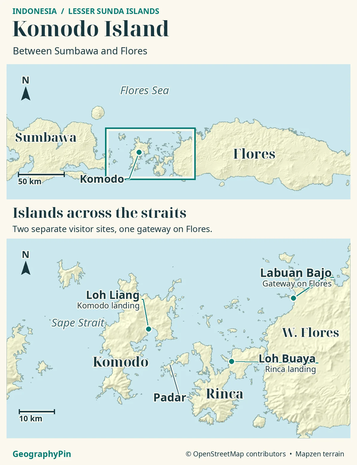
Komodo Island lies between Sumbawa and Flores in eastern Indonesia. It is one of the main islands of Komodo National Park, alongside Rinca and Padar. The park also protects surrounding waters, but its boundary does not contain the whole wild range of the Komodo dragon.
How to use this article: Start with the island versus the park, compare the two dragon-viewing landings, then see why older maps differ on Padar and where the wild range extends beyond the park.
Where Komodo Island Is in Indonesia
Komodo lies in the Lesser Sunda Islands of eastern Indonesia, in East Nusa Tenggara province. On a west-to-east map, look for Sumbawa first, then Komodo, then the islands and channels that lead toward western Flores. The Sape Strait is on Komodo’s western side. Labuan Bajo, where many park visits start, is a town on Flores rather than a port on Komodo itself.
The island is one part of a larger park
Komodo Island is a physical landmass. Komodo National Park covers several islands and waters around them, including the other two major islands, Rinca and Padar. The UNESCO World Heritage property is listed under the park’s name. A map label for Komodo Island does not mark the edge of the park, and a park boundary does not trace just one shoreline.
Komodo Island: Hills, Bays and Loh Liang
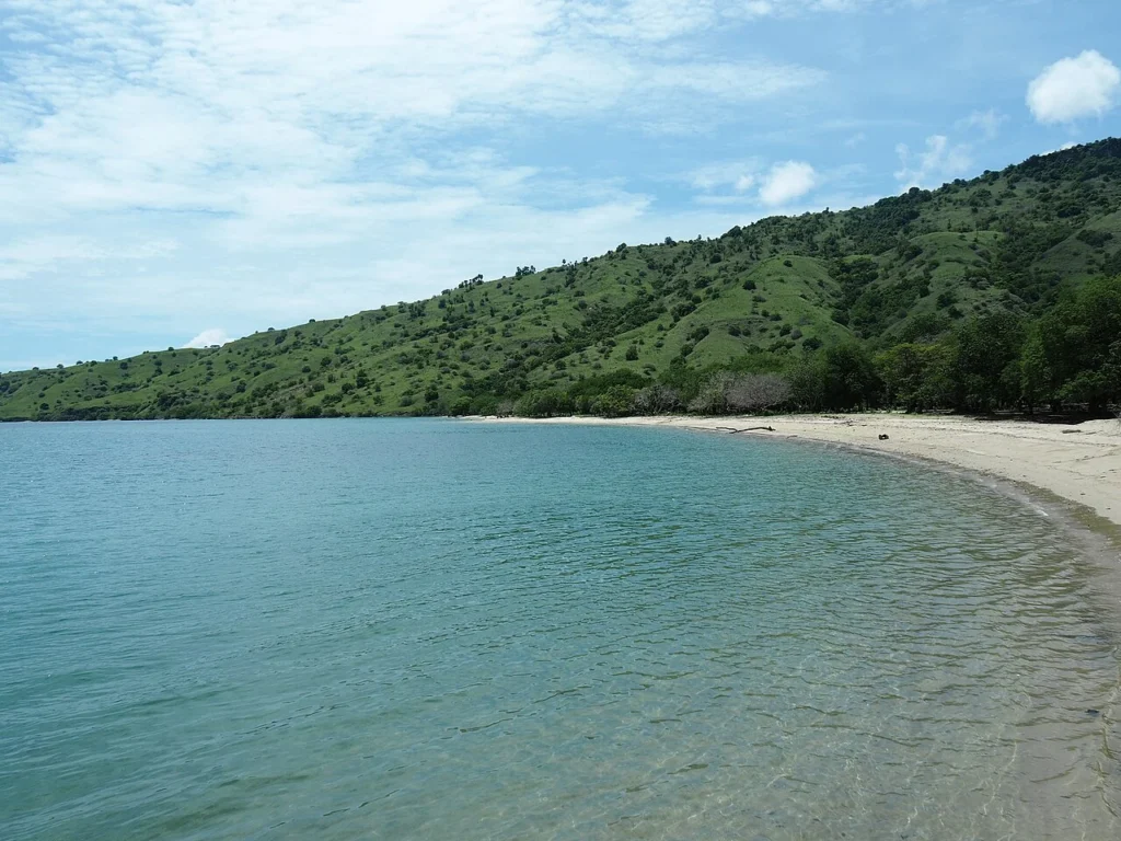
The island’s uplands and indented coastline explain why a short distance on a map may involve a boat journey rather than a walk. UNESCO describes the park’s major islands as volcanic in origin. Dry hillsides, seasonal vegetation and a varied coast meet around the valleys and bays. The contrast is easiest to see from the water: ridges can rise quickly behind a landing without the entire coast looking the same.
Loh Liang and Loh Buaya are on different islands
Loh Liang is a park visitor site on Komodo Island. Loh Buaya is on Rinca. Both are associated with ranger-led dragon viewing, but between them are saltwater channels, not a walking route. If a boat itinerary says “Komodo National Park,” check which island and visitor site it actually lists.
Rinca, Padar and the Other Islands Where Dragons Live
Komodo and Rinca account for most of the park’s estimated dragons in the park authority’s 2024 monitoring. Gili Motang and Nusa Kode also have documented populations. Padar’s history is more complicated than an old range map may suggest: older sources reported local disappearance, but recent official monitoring reports a small population there.
Why some dragon maps leave Padar out
On Padar, the park authority’s March–October 2024 survey estimated 28 dragons. The reported total across the park was about 3,270, with an uncertainty of ±371. These are dated estimates, not exact counts or evidence that a visitor will see one. Padar’s scenic viewpoint and its status in a wildlife survey answer different questions.
Western Flores: A Gateway and Habitat Outside the Park
Western Flores matters in two separate ways. Labuan Bajo connects visitors to offshore islands, while separate wild dragon populations occur in parts of Flores outside the national park. The species’ range is fragmented, so a marker on Flores should not be read as a claim that dragons occupy the entire island, much less the streets of Labuan Bajo.
Where the wildlife range and legal boundary differ
A park map shows an area managed for conservation. A wildlife survey asks which populations are actually present. Neither line can substitute for the other. The park extends across marine waters where dragons do not live as terrestrial populations, while research records wild populations on Flores beyond the park.
What to Check Before Choosing a Boat Trip
Separate three things on a proposed itinerary: the mainland departure port, the island landing and the activity at that landing. A dragon walk at Loh Liang, a visit to Loh Buaya and a view from Padar are not interchangeable stops. An itinerary may also include marine locations with no land visit.
Consult the park’s current notices or visitor center for access, quotas and opening conditions, and confirm the stops with the boat operator. Follow ranger directions on land. Only current local information can tell you whether a particular landing is available for the day you plan to travel.
Frequently Asked Questions
Is there a road or bridge from Flores to Komodo Island?
No. Open water separates the islands. Labuan Bajo is the Flores departure town; access to Komodo Island is by boat.
Are Gili Dasami and Nusa Kode two different islands?
No. Indonesia’s conservation authority uses Gili Dasami as another name for Nusa Kode, one of the smaller islands with a documented dragon population. Gili Motang is a different island.
What Did We Learn Today?
Komodo is one island in a multi-island national park. Rinca and Padar are separate landmasses, and Labuan Bajo is on Flores. Wild dragons occur both within the park and in parts of Flores beyond it. Choose the actual landing, rather than assuming every tour called “Komodo” stops on the island.
Sources & Data Notes
The March–October 2024 figures are park authority estimates reported by Indonesia’s In-Flores programme, not direct counts or current sighting reports. Older references excluded Padar or described local disappearance; the 2024 report includes Padar. The map identifies islands and visitor locations, not a complete habitat or legal-boundary survey. Visitor sources checked November 2026.
- Indonesian conservation authority: Nusa Kode also called Gili Dasami
- UNESCO: Komodo National Park World Heritage property and island geography
- Park environmental assessment: range and 2015–2019 monitoring
- Indonesian forestry authority: 2024 park monitoring and Padar estimate
- Jones et al. (2020): geographically fragmented populations on Flores
- Komodo National Park authority: sites and current visitor notices
- Indonesia tourism authority: ranger viewing locations and Labuan Bajo
Map: GeographyPin original atlas using OpenStreetMap coastlines, Loh Liang, Loh Buaya pier and Labuan Bajo port, retrieved November 19, 2026. © OpenStreetMap contributors, ODbL. Relief from Mapzen/AWS Terrain Tiles and underlying elevation sources. No visitor route, habitat boundary or park boundary is drawn.
Photograph: Komodo Island Shore, Hotel Kaesong, 2018, CC BY-SA 2.0. Resized and converted to WebP.