Indonesia stretches across the equator as a chain of large islands, smaller island groups and intervening seas. Its geography brings volcanic mountains, crowded urban corridors, broad river lowlands and remote highlands into one country. Java is central to its population and economy, but understanding Indonesia means looking well beyond Java and Bali.
Indonesia is an archipelagic country between the Indian and Pacific oceans, extending from Sumatra through Java, Kalimantan and Sulawesi to western New Guinea. Its islands have sharply different terrain and settlement patterns. Jakarta’s capital role and the development of Nusantara require a dated legal distinction: building the new capital is not the same as completing the formal transfer.
How to use this article: Compare the main island landscapes, explore why Java matters, or clarify Jakarta and Nusantara.
1. Locate Indonesia and read its map
Indonesia occupies a broad equatorial belt south of mainland Southeast Asia and north of Australia. Sumatra lies west of Java, Kalimantan is the Indonesian part of Borneo, and Sulawesi lies farther east across the Makassar Strait. The Maluku islands and Indonesian Papua extend the country toward the western Pacific.
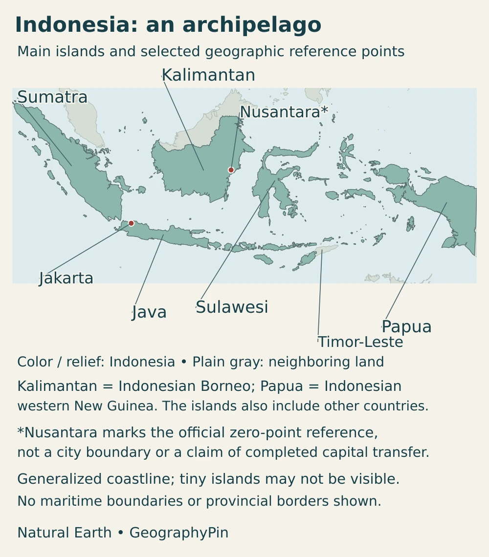
Several major islands are shared across international borders. Borneo also contains Malaysian territory and Brunei; New Guinea is divided between Indonesia in the west and Papua New Guinea in the east. Indonesia occupies western Timor, while Timor-Leste includes the eastern part and the Oecusse enclave in the west. A whole island silhouette is therefore not always an Indonesian national boundary.
Indonesia is normally grouped within Southeast Asia. Its eastern islands also have strong physical and biological connections with the Australasian region. Geographic regions, island names and sovereign borders answer different questions and should not be treated as interchangeable.
2. Country facts with dates and definitions
| Item | Figure or description |
|---|---|
| Capital transition | Jakarta retains the capital role until the presidential transfer decree takes effect; the Constitutional Court confirmed that the decree had not been issued on October 29, 2026. Nusantara is the designated new capital under development. |
| Population | 284.67 million in the 2025 Intercensal Population Survey (SUPAS), reported by Statistics Indonesia in May 2026 |
| Area | Approximately 734,000 square miles (1.9 million km²); rounded geographic area, not a combined land-and-maritime jurisdiction total |
| Island inventory | 17,380 named and georeferenced islands in BIG’s 2024 inventory, also used in its December 2025 national map release |
| National language | Indonesian (Bahasa Indonesia) |
| Time zones | WIB (UTC+7), WITA (UTC+8) and WIT (UTC+9) |
| Currency | Indonesian rupiah (IDR) |
| Government | Unitary republic with a presidential system |
| Provinces | 38 in BIG’s December 2025 national map release |
The population total above is a dated survey result, not a live population counter or a 2026 census. Projections for another reference year can differ without contradicting that survey. The island count likewise describes a particular inventory rather than a permanent, method-free total.
BIG counts natural land surrounded by water and remaining above the highest tide; reclaimed land does not qualify under that definition. Changes in the inventory can reflect verification, erosion or islands joining together, not simply newly formed islands. The 2024 update added names and coordinates while other entries changed, so the net increase should not be read as a count of new volcanic islands.
3. An archipelago of contrasting landscapes
Mountains and lowlands across different islands
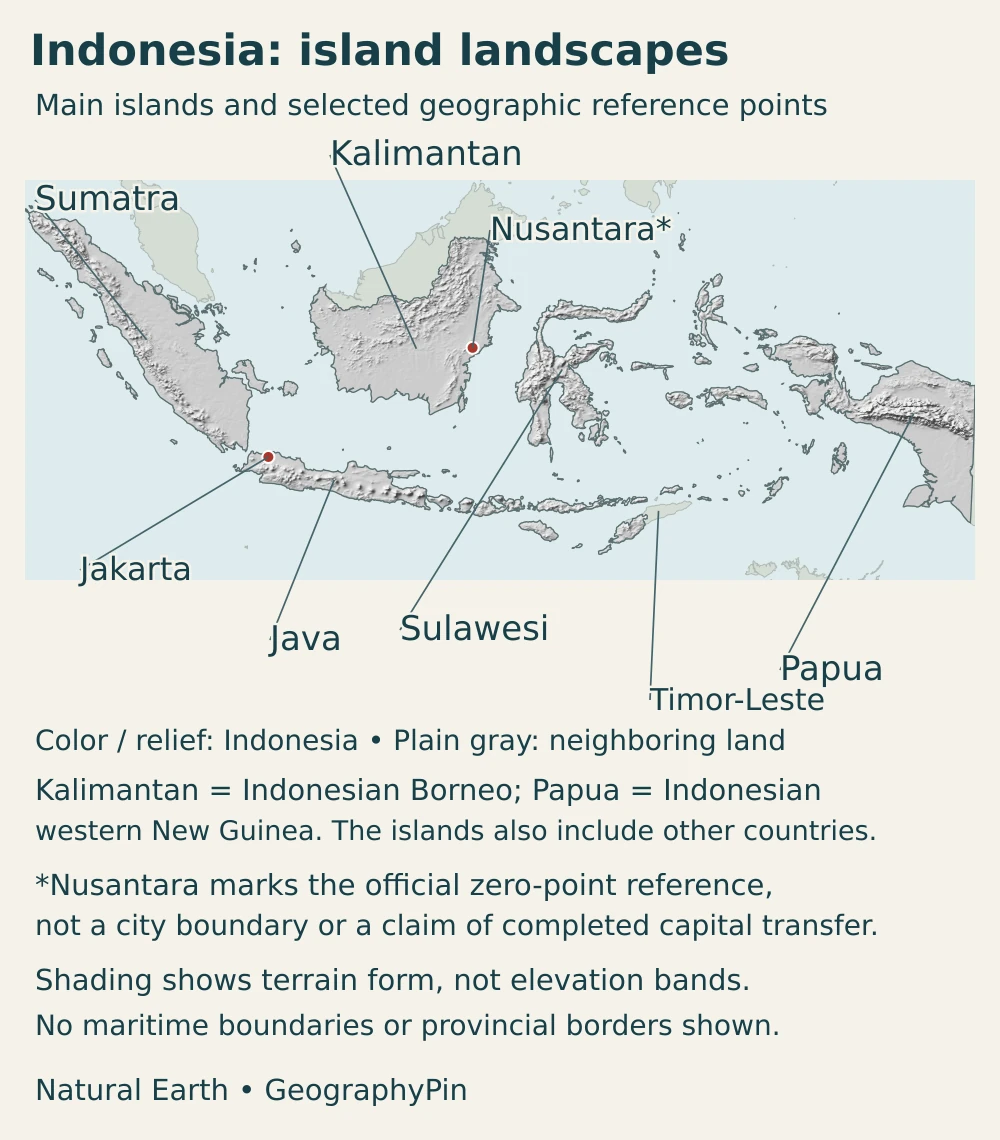
Indonesia is not one continuous mountain chain surrounded by identical beaches. Sumatra has a mountainous western spine and extensive eastern lowlands. Java combines volcanic uplands with plains and densely settled corridors. Kalimantan has broad river basins and interior uplands, while Sulawesi’s branching peninsulas enclose deep bays. Indonesian Papua includes rugged highlands as well as extensive lowlands. Puncak Jaya reaches about 16,024 feet (4,884 m), a reminder that equatorial geography can include very high mountains rather than only warm coastal plains.
| Island or region | Main landscape contrasts | Why the distinction matters |
|---|---|---|
| Sumatra | Western mountain belt and eastern river lowlands | Relief influences drainage, forest environments and routes between coasts |
| Java | Volcanic mountains, cultivated slopes, basins and coastal plains | Intensive settlement and farming coexist with active geological processes |
| Kalimantan | Interior uplands, large river basins and low coastal plains | Rivers connect inland districts with towns and ports; it is only the Indonesian part of Borneo |
| Sulawesi | Mountainous peninsulas and deeply indented coasts | Nearby places across a bay can be separated by long overland routes |
| Bali and Nusa Tenggara | A sequence of islands with varied volcanic and non-volcanic terrain | Island crossings and stronger seasonal dryness in many areas distinguish this belt |
| Maluku and Indonesian Papua | Scattered island groups, rugged mountain terrain and large lowland settings | Neither landscape nor settlement can be represented by a single Java-based model |
The Sunda Shelf links the physical setting of Sumatra, Java and Borneo with continental Asia, while the Sahul Shelf connects New Guinea’s setting with Australia. Between them lies Wallacea, including Sulawesi and many islands farther southeast. These geographic and biological divisions help explain why nearby islands can have different animal communities. Wallace’s Line is a biogeographic distinction, not an international border or a rule that every species obeys.
Volcanoes do not make every island equally hazardous
Subduction is central to the geology of Sumatra and Java: one tectonic plate descends beneath another, producing earthquakes and helping generate magma. The offshore trench, island-arc mountains and volcanoes are connected parts of that system. Eastern Indonesia contains additional plate interactions, so a simple line around the country cannot describe all its geology.
Java’s Mount Sundoro and Mount Sumbing are concrete examples of volcanic peaks rising above a cultivated landscape. Volcanic materials can contribute to soils, but farming also depends on water, slope, management and access. A productive volcanic landscape is not free of eruption hazards, and an island’s presence in a tectonically active country does not mean every location faces the same risk.
Earthquakes, eruptions and tsunamis are different processes. Not every earthquake produces a tsunami, and not every volcanic mountain is erupting. Local official monitoring and hazard maps are needed for current conditions; this country map explains the geographic setting rather than predicting an event.
4. Climate, rivers and environments
Tropical does not mean the same rainy season everywhere
Lowland Indonesia is generally warm, but elevation creates cooler mountain environments. Rainfall varies with monsoon winds, island orientation, nearby seas and relief. In many regions the wetter season centers on December through February and the drier season on June through August, but that pattern is not universal.
Ambon provides a useful counterexample: its seasonal rainfall pattern differs from the common western Indonesian pattern. Some equatorial areas have much less distinct wet and dry seasons. Even on one island, a mountain barrier and coastal exposure can produce contrasts that a single national monthly average would conceal.
Waterways connect inland landscapes and coastal towns
The Kapuas in West Kalimantan illustrates the importance of rivers beyond Java. At Pontianak, waterways shape the city’s setting and link inland districts with the coast. The river is also a transport and supply route: sediment accumulating in the shipping channel can affect access to the port, showing how a physical process becomes an economic constraint.
Forest environments are equally varied. Sumatra’s protected rainforest landscapes include both lowland and mountain forests, rather than one uniform band of vegetation. Changes in elevation, drainage and soil conditions create different habitats. Protecting an upland forest and managing a lowland river corridor involve connected but distinct geographic challenges.
Heavy rainfall can raise river levels or destabilize slopes, while dry periods affect water availability. Flood exposure depends on drainage, land use and the position of settlements as well as rain totals. The same amount of rainfall will not have the same effects on a steep hillside, a floodplain and a well-drained urban district.
5. People, cities and languages
Java is the population center, not the whole country
Statistics Indonesia’s 2025 intercensal survey placed 55.65% of the population on Java. That concentration is striking because several other Indonesian islands are geographically much larger. Java’s long-established farming landscapes, cities and transport connections help explain why a map of population would look very different from a map of land area.
Jakarta occupies a coastal setting in northwestern Java. Surabaya is an important urban center in eastern Java, while Bandung has an upland setting in western Java. Beyond the island, Medan in Sumatra, Makassar in Sulawesi and cities in Kalimantan and Papua serve distinct regional networks. An overview focused only on Jakarta and Bali would miss much of the country’s urban geography.
City populations need clear boundaries. An administrative city, a continuously built-up area and a metropolitan region are not the same unit. Jakarta’s wider urban region extends beyond its administrative boundary, so a metropolitan total should not be presented as the population of the city alone.
A common national language in a multilingual country
The constitution identifies Indonesian as the national language and recognizes regional languages as part of the country’s cultural heritage. Indonesian provides a shared language across the archipelago, but it does not erase the distinct linguistic communities of Java, Sumatra, Sulawesi, Papua and other islands. Nationality, home language and island of residence are different aspects of identity.
6. Government and economy across the islands
Jakarta and Nusantara are not interchangeable labels
Indonesia’s constitution establishes a unitary republic with a president. The capital transition adds a separate, time-sensitive question: Nusantara has been designated as the new capital and is being developed in East Kalimantan, but the legal transfer depends on a presidential decree. In its October 29, 2026 decision, the Constitutional Court explicitly referred to that decree as not yet issued. Its earlier May decision explained that Jakarta retained the capital position and functions until the transfer decree took effect.
The distinction is between designation, construction and legal effectiveness, not between two names for the same city. Jakarta is on Java; Nusantara is on Borneo. A map marker at Nusantara locates the development area but does not establish that every national institution has moved or that the legal transfer is complete.
Production and transport have different regional centers
Indonesia’s economy links urban services, manufacturing, agriculture, extraction and maritime trade across a fragmented land surface. The dense settlement of Java creates large markets and extensive connections between cities, while other islands contribute resources and regional production networks. Distance across water makes ports, shipping and connections between islands important parts of that system.
Nickel processing in Sulawesi offers a specific example of activity beyond Java. The energy ministry’s account of the Kolaka smelter project in Southeast Sulawesi illustrates the connection between mineral resources, industrial facilities and regional infrastructure. It does not mean that all of Sulawesi has the same economy or that a project’s announced capacity is identical to actual production.
River transport provides another connection: the Kapuas shipping channel supports goods movement in West Kalimantan, while sedimentation can constrain access. Geography therefore influences both where production occurs and how products reach markets. The rupiah is the national currency across these different regional economies.
Frequently Asked Questions
Is Jakarta or Nusantara Indonesia’s capital?
Nusantara is the designated new capital, but the formal transfer depends on a presidential decree. The Constitutional Court’s October 29, 2026 decision stated that the decree had not been issued; Jakarta retained the capital role under the transition framework. Construction progress and legal transfer are separate matters, so the date of a source matters.
Does Indonesia include all of Borneo and New Guinea?
No. Kalimantan is Indonesia’s part of Borneo, which is shared with Malaysia and Brunei. Indonesia occupies the western part of New Guinea; Papua New Guinea occupies the eastern part. Island names describe physical landmasses, not necessarily one country’s territory.
Why do different sources give different numbers of Indonesian islands?
Counts depend on the reference year, mapping verification and the definition of an island. BIG’s 2024 inventory listed 17,380 named and georeferenced islands. Erosion, merging and improved identification can change the list; a different total does not necessarily mean thousands of islands suddenly appeared or disappeared.
What Did We Learn Today?
Indonesia combines volcanic island arcs, large river lowlands, rugged peninsulas and highlands across an enormous archipelago. Java’s population concentration is only one part of that geography. Shared islands require careful boundary reading, rainfall seasons vary between regions, and rivers and seas connect production with settlement. Keeping survey dates, island-count methods and the Jakarta–Nusantara legal transition clear makes the country easier to understand.
Sources & Data Notes
- Indonesian Geological Agency, vertebrate-fossil atlas (2023): Section 1.4, printed pages 8–9, on Sunda, Sahul and Wallacea; no historical island counts reproduced.
- NASA, Puncak Jaya mountain setting: 4,884 m elevation; historical ice imagery is not used as a current glacier extent.
- OPEC Fund, Indonesia country profile: Rounded area only; population and other indicators use their separately dated primary sources.
- BMKG, Indonesian standard time: Three national standard-time zones and UTC offsets.
- Statistics Indonesia, SUPAS 2025 results: 2025 survey population and Java share, reported May 6, 2026; not a 2026 projection.
- Constitutional Court, October 29, 2026 decision: The court’s account of the unissued transfer decree, distinguished from petitioners’ arguments.
- Constitutional Court, May 12, 2026 decision: Jakarta’s capital role until the presidential transfer decree takes effect.
- BIG, 2024 island inventory: 17,380 named and georeferenced islands; definition and reasons for changes.
- BIG, national map release 2025: 38 provinces, island inventory and national mapping scope.
- Indonesia, official English constitution: Republic, presidency, national language and regional-language heritage.
- NASA, Sumatra subduction zone: Stable tectonic explanation, not a current earthquake forecast.
- NASA, Java’s Sundoro and Sumbing: Volcanic terrain and surrounding cultivated landscape.
- ECMWF, Indonesian convective weather: BMKG meteorologist’s explanation of monsoonal and local rainfall contrasts.
- Pontianak municipal government, geography: City setting and waterways.
- West Kalimantan government, Kapuas shipping channel: August 2026 evidence of river transport and sedimentation constraints.
- UNESCO, Tropical Rainforest Heritage of Sumatra: Lowland and mountain forest environments; no species totals reproduced.
- Energy Ministry, Sulawesi nickel processing: Dated 2024 project evidence illustrating regional industry, not current output.
- Bank Indonesia, rupiah: National currency and legal-tender status.
Map sources and scope: Original GeographyPin maps use public-domain Natural Earth country and city data, together with its georeferenced shaded-relief raster. Both maps use one Lambert azimuthal equal-area geographic frame centered near 2°S, 118°E, without moving islands into separate insets. Terrain shading is not an elevation classification or a map of active volcanoes.
Coastlines and boundaries are generalized: small islands and fine coastal changes may be absent at this scale. Shared Borneo, New Guinea and Timor are not colored as wholly Indonesian. The maps do not depict territorial waters, provincial boundaries or adjudicate maritime claims; they are not substitutes for an official legal boundary map. The cartographic number of polygon components is not the country’s real-world island count.
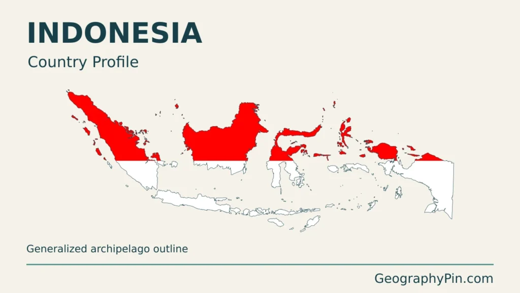
Nusantara is located using the official zero-point reference in the Nusantara Authority’s Regulation 3/2024. This point is not a city boundary, and neither map assigns legal capital status through its symbols. The cover uses a public-domain Indonesian flag vector, uniformly scaled and decoratively clipped to the country outline. GeographyPin branding identifies the original composition, not an official government map.