Island-hopping tours in Palawan usually begin with a choice of base: El Nido for Bacuit Bay, or Coron town for the islands and waters around Busuanga and Coron Island. The names on a booking page can hide important differences between the town, airport and island you want to visit.
El Nido or Coron: where the tours start
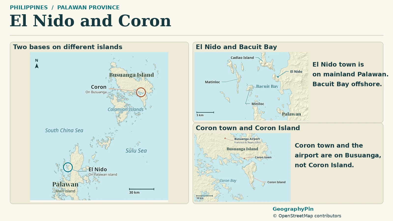
El Nido is on northern Palawan Island and is the base for Bacuit Bay tours. Coron town is on Busuanga Island, while Coron Island lies across the water. Flying to Coron means arriving at Busuanga Airport, not on Coron Island. Choose the base that matches the named attractions on your itinerary.
How to use this article: choose the right base, decode El Nido tour letters, understand Coron Island access, separate the arrival legs.
The Islands on a Regional Map
Palawan is both a province and the name of its long main island in the western Philippines. An island-hopping holiday advertised as “Palawan” can therefore involve quite different islands. El Nido and Coron are two bases within the province, not two towns on the same continuous stretch of road.
El Nido occupies northern main Palawan. Its town faces Bacuit Bay, where boats visit offshore islands and limestone-fringed coves. Coron town is farther north on Busuanga Island, in the Calamian group. Coron Island is a separate landmass south of Busuanga.
Choose the base before the tour
| What you want to explore | Usual base | Geographical distinction |
|---|---|---|
| Bacuit Bay lagoons, beaches and islands | El Nido | The town is on main Palawan; the island stops are offshore. |
| Coron Island lakes and lagoons | Coron town | The town is on Busuanga; the destination island is across the water. |
| Both areas | A stay in each base | A transfer between bases is a separate journey, not an ordinary local day-tour stop. |
If your priority is a particular lagoon or lake, locate that feature first. Then choose accommodation and arrival transport around its appropriate base. A bargain tour in the wrong town does not solve the distance between the two areas.
Bacuit Bay From El Nido
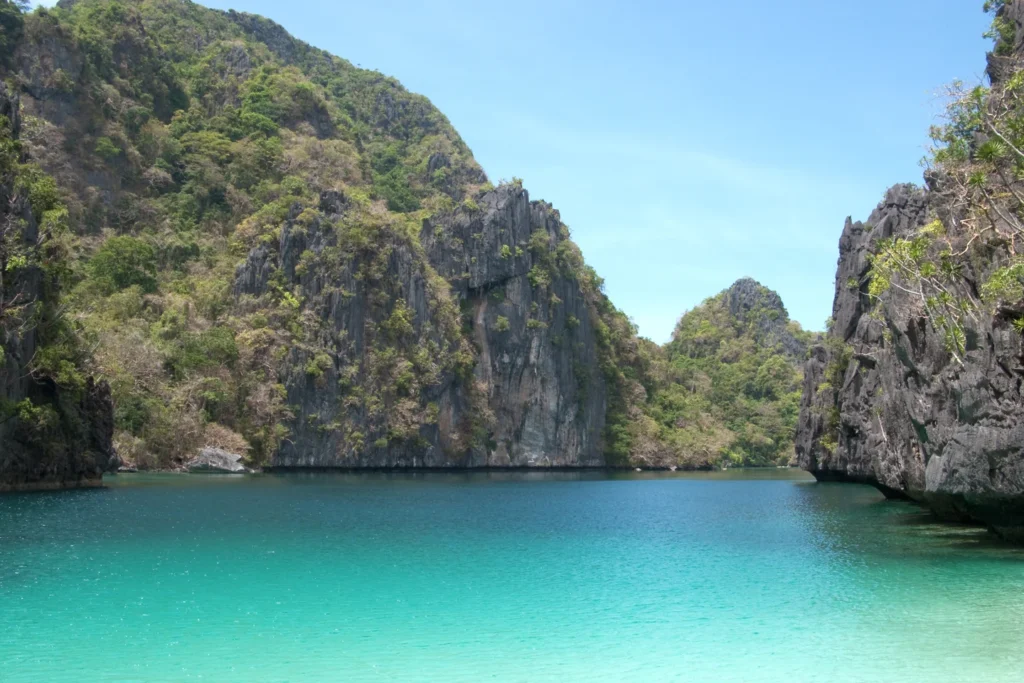
El Nido’s familiar island-hopping landscape belongs to the Bacuit Archipelago. The Department of Tourism identifies Bacuit Bay’s lagoons and islands as the focus, including Big Lagoon, Small Lagoon and Matinloc Island. These are different stops within a coastal island landscape, not separate names for El Nido town.
Limestone cliffs are a defining feature, with beaches and water-filled openings between steep rock walls. A photograph of a sheltered lagoon does not show all the water a boat must cross to reach it.
What the tour letters help you compare
Operators commonly sell El Nido outings as Tours A, B, C and D. Treat those letters as a starting point for comparison, then read the actual stop list. One operator’s published categories associate A with lagoons around Miniloc, B with caves and Snake Island, C with beaches around Matinloc, and D with Cadlao-area lagoons and beaches.
Those examples describe the advertised geography, not a guaranteed itinerary. Listings can distinguish regular and premium versions, substitute stops or handle lagoon arrangements separately. Ask which named sites are included, whether a desired lagoon is confirmed, and whether kayaking, equipment or site charges are additional.
For a first comparison, choose between a lagoon-focused day, caves and sandbar scenery, or a beach-focused outing. Counting the largest number of advertised stops is less useful than finding the landscape you actually want to experience. Do not assume that adding a stop also adds enough time to enjoy it.
Coron Island and Its Surrounding Waters
Coron Island is the steep limestone island across the water from the town used as a tourism base. Kayangan Lake, Barracuda Lake and Twin Lagoon belong to the island’s visitor landscape. They should not be plotted inside Coron town or on the airport island simply because their listings share the name “Coron.”
| If you want to see… | Start from… | Confirm when choosing a tour |
|---|---|---|
| Big Lagoon on Miniloc, Bacuit Bay | El Nido | Look for an outing naming Big Lagoon and check entry arrangements and whether kayaking is included. |
| Kayangan Lake on Coron Island | Coron town, on Busuanga | Look for a Coron Island lakes-and-lagoons trip naming Kayangan. Confirm the boarding point and permitted visit. |
The wider Coron area also includes beaches, reefs and wreck-diving locations. A lake-and-lagoon day, a beach outing and a diving trip are different products, even when all are sold from the same waterfront. Read the named sites and activity requirements rather than expecting every “Coron tour” to include all three.
The destination island is also a lived landscape
Coron Island is associated with the Tagbanua Indigenous community and its ancestral domain. The Philippine submission on UNESCO’s Tentative List describes community settlements, limestone terrain and offshore ancestral fishing grounds. A Tentative List entry is a proposal, not World Heritage inscription; it does not change local access permissions.
A marketed stop is not permission to explore every nearby lake, cave or shore. Respect community guidance and access limits. Being able to see a feature from a boat, photograph or map does not establish that visitors may enter it.
For a practical comparison, ask whether the advertised day is centered on Coron Island or on other islands in the wider area. This single question prevents an attractive beach image from being mistaken for a promised visit to the island’s lakes.
Busuanga: The Arrival Island for Coron
Flying to “Coron” does not land you on Coron Island. The airport serving this destination is Francisco B. Reyes Airport, commonly called Busuanga Airport, with the code USU. It is on Busuanga, the island that also contains Coron town.
Separate the air, road and boat legs
The arrival sequence is easiest to understand as separate legs: airport arrival on Busuanga, road travel to the exact accommodation or departure point, and a boat journey if visiting Coron Island. An accommodation described as “Coron” may not have the same transfer requirements as another hotel with the same destination label.
Check the actual address before booking an airport pickup. If you are staying on an offshore resort island rather than in town, ask the property where its land transfer ends and whether a further boat transfer is included. The airport code alone cannot answer that question.
Likewise, a transfer between El Nido and Coron is separate from a local island-hopping tour. Do not plan a same-day connection solely around a map’s straight-line distance. Confirm the operating service, departure point, luggage arrangements and cancellation terms for your own date.
Island names, local boundaries and access
Physical islands, municipalities and tour areas are three different ways of dividing this coast. El Nido municipality includes mainland terrain and offshore islands; it is not merely the waterfront town center. Coron municipality is not identical to Coron Island. Busuanga Island also should not be confused with the municipality bearing the Busuanga name.
The distinction matters when reading accommodation addresses, conservation descriptions or maps. An administrative boundary is not a shoreline, and a tour company’s collection of stops is not an official island boundary.
The Palawan Council for Sustainable Development’s coastal mapping describes reefs around Busuanga and Coron Island as well as adjacent seabed habitats. A tourist map showing only dry land leaves out much of the physical setting. Turquoise water on a map or photograph is not evidence of safe swimming or navigable depth.
Before departure, confirm the day’s arrangements with the operator and follow local authorities’ restrictions. Wear the required flotation equipment and do not treat a familiar tour name or a sunny view from town as a guarantee of conditions offshore.
Frequently Asked Questions
Does a private boat mean unrestricted access to every stop?
No. A private booking changes who shares the boat, not the permissions attached to a place. Ask which stops are confirmed and what happens if a site cannot be visited; do not assume that paying for a private trip overrides local access limits.
Should I stay in El Nido or Coron for Kayangan Lake?
Coron town, on Busuanga, is the local base. Kayangan Lake is on Coron Island across the water, so the last leg is a boat outing, not a road drop-off from Busuanga Airport. Ask for Kayangan by name.
What Did We Learn Today?
El Nido and Coron open onto different island-hopping areas. Bacuit Bay lies off northern main Palawan; Coron town and its airport are on Busuanga, across the water from Coron Island. Matching a named attraction to its physical island, departure base and access arrangements is more useful than choosing a tour by its destination label alone.
Sources & Data Notes
- Department of Tourism: Palawan and Bacuit Bay
- Department of Tourism: El Nido
- Department of Tourism: Coron
- Palawan Council for Sustainable Development: El Nido resource-management plan, 2015–2020
- Palawan Council for Sustainable Development: coastal habitat report, 2024
- Municipality of Busuanga: arrival information
- Two Seasons Coron Bayside: town and island arrival distinction
- Hello El Nido: operator examples of lettered tours
- UNESCO: Coron Island Natural Biotic Area, Tentative List
Sources checked November 19, 2026. Tour categories are examples of marketed products, not promised stop lists. No current fare, permit availability, departure time or sea-condition guarantee is asserted. Older planning documents support geographical distinctions, not present population counts or current operating rules. The map is a locator, not a navigation chart.
Map: GeographyPin original atlas using OpenStreetMap shorelines from November 18, 2026, and mapped El Nido, Coron town, Busuanga Airport and island positions checked November 19. © OpenStreetMap contributors, ODbL. Shaded relief: Mapzen/AWS Terrain Tiles and underlying elevation sources. Town rings are locators, not jurisdictional boundaries; no boat tracks or permit areas are shown.
Photograph: Limestone islands in Bacuit Bay, Vyacheslav Argenberg, March 9, 2009, CC BY 4.0. Resized and converted to WebP. This historical view shows El Nido’s Bacuit Bay, not Coron.
