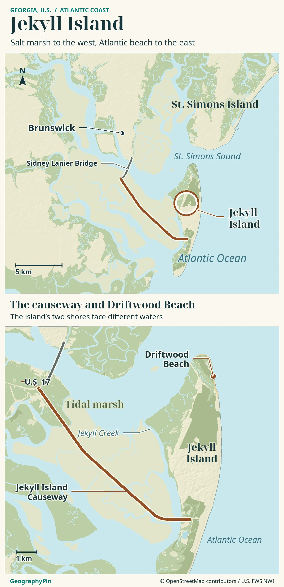
Jekyll Island lies off Georgia’s Atlantic coast in the United States, with ocean beaches on one side and tidal marsh toward Brunswick on the other. Its exposed trees at Driftwood Beach make more sense when the whole barrier-coast setting is visible.
Where Jekyll Island fits on the Georgia coast
Jekyll Island is a barrier island near Brunswick in Georgia, the U.S. state. A causeway connects it to the mainland across a tidal coastal landscape. Driftwood Beach occupies part of its northern shoreline, where erosion has exposed trees; the beach reflects continuing coastal change, not only hurricane damage.
How to use this article: read the coastal layers, understand the causeway, check a tide location, explain the exposed trees.
Jekyll Island beside Brunswick and St. Simons Sound
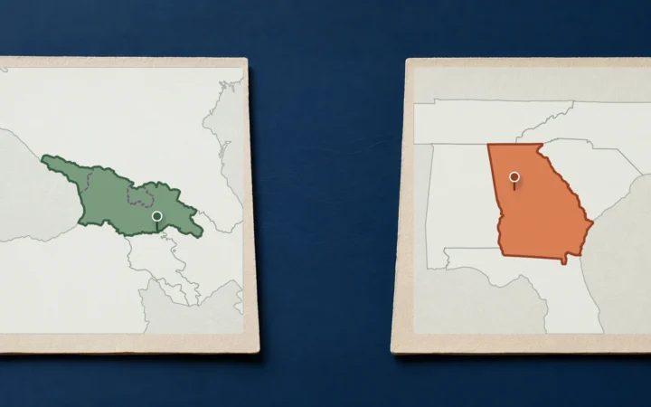
Jekyll Island is off the Atlantic coast of Georgia, the U.S. state, in Glynn County near Brunswick. It belongs to the coastal barrier-island landscape of the Golden Isles. It is not connected geographically with Georgia, the country in the Caucasus.
Brunswick is on the mainland side; the Atlantic lies to the east; tidal waterways and marsh occupy the space behind the barrier. St. Simons Island is a separate island to the north, across St. Simons Sound.
Read the island from sea to mainland
| Feature | Where to look | What it explains |
|---|---|---|
| Ocean beach and dunes | Atlantic-facing side of the island. | Wave exposure and movement of beach sand. |
| Island interior | Land between the ocean shore and back-barrier waters. | Forest, development and older coastal landforms. |
| Tidal marsh and creeks | Mainland-facing side and surrounding estuary. | Water exchange and wetland habitat behind the barrier. |
The causeway from Brunswick
Jekyll is reachable by a road causeway from the mainland near Brunswick. The local tourism bureau identifies the causeway’s connection with U.S. 17 near the southern end of the Sidney Lanier Bridge. The road crosses a coastal wetland setting rather than turning all the intervening marsh into continuous dry land.
Keep Brunswick, the causeway and the island’s own roads separate when planning arrival. A mainland hotel address is not an island address, and an island entrance is not the same point as a beach access.
A road connection does not erase the island
A causeway is transport infrastructure across the gap. Jekyll remains a barrier island, with tidal water and marsh separating it from mainland terrain. The causeway crosses marsh and tidal waterways; it does not turn the wetland into a broad strip of mainland.
Check the Jekyll Island Authority for current parking or access arrangements before traveling. Reaching the island by road also does not establish that every shore access is open or suitable at the time you arrive.
Tidal marsh behind the ocean shore
The grassy landscape behind Jekyll is tidal salt marsh, not unused ground waiting to become a beach. Georgia’s Department of Natural Resources describes these wetlands as a system of vegetation crossed and drained by tidal creeks. Their appearance changes as water moves in and out.
Salt-tolerant plants can live where ordinary upland vegetation struggles. Their root systems help hold marsh sediment together. The channels, plants and sediment are parts of one coastal habitat. In the atlas, the green marsh is interlaced with waterways rather than shown as continuous dry ground.
Why the tide station matters
NOAA lists a prediction location named Jekyll Island Marina, Jekyll Creek. That name identifies a creek-side location, not a measurement taken at every ocean beach. When consulting a tide table, check the station, date, time zone and units rather than assuming that all pages labelled “Jekyll tides” refer to the same place.
A prediction is not a promise that a particular beach path will be clear. Weather, waves and local shoreline shape also affect conditions. Follow current local guidance and posted restrictions; a low-tide time alone is not permission to cross channels, mudflats or a closed access.
Why Driftwood Beach has exposed trees
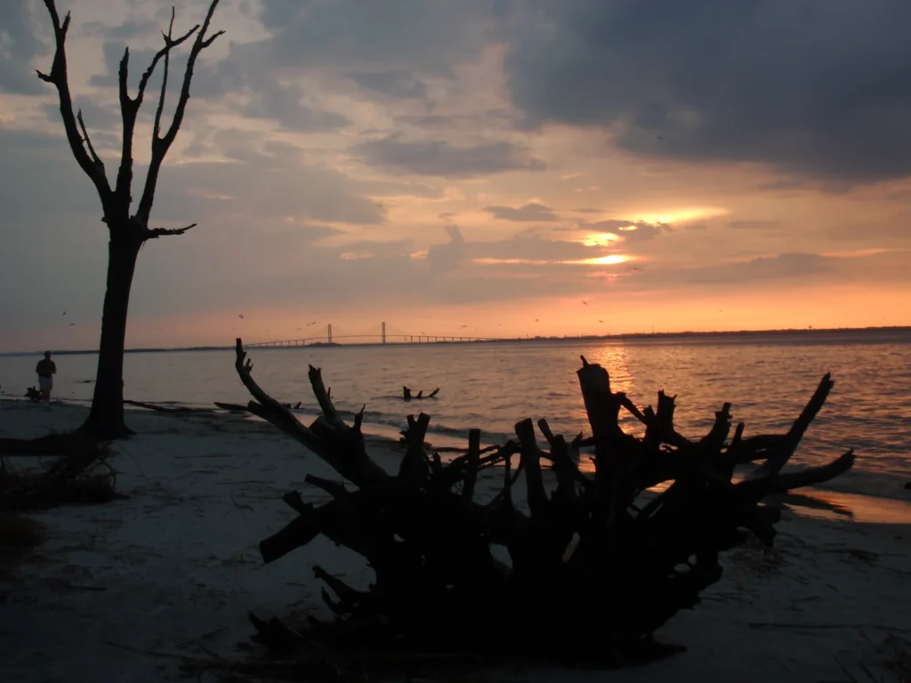
Driftwood Beach is at Jekyll’s northern end, along the north to northeast shoreline rather than the marsh-facing western shore. Its exposed trunks and roots are evidence of a changing coastal edge, not simply a collection of trees delivered from somewhere else by one storm.
The forest edge becomes the beach
The Jekyll Island Authority describes long-term erosion and accretion around the island. Erosion removes ground at parts of the shore; accretion adds sediment elsewhere. As the shoreline cuts into wooded ground, trees lose support and become exposed or fall onto the beach. Waves and tides then rework the surrounding sand.
Hurricanes can accelerate change, but a hurricane-only explanation misses the ongoing process. U.S. Army Corps of Engineers research identifies chronic erosion and sediment starvation alongside recent hurricane impacts near Driftwood Beach. The distinction matters: the trees record a shifting shore, not a single dated wreckage event.
Change is not uniform around Jekyll. The Authority contrasts eroding areas with sediment gains at the southern end and notes that these patterns can shift. It would be misleading to take a photograph of exposed trees and conclude that every part of the island is retreating at the same rate.
The beach is also not a fixed arrangement of trunks for visitors to find exactly as pictured. Use current marked access, respect barriers and vegetation, and do not assume that a photographic viewpoint remains reachable under every tide or wave condition.
The changing shoreline and its management
Barrier islands are built and reshaped by sediment movement. NOAA describes ocean-facing beaches and dunes paired with landward tidal environments; USGS distinguishes gradual change driven by waves, tides and currents from faster change during extreme storms. These are general coastal processes, not a forecast for a particular Jekyll property.
A shoreline therefore needs a date and a definition. The water’s edge in an aerial photograph can differ from a mapped high-water line, a dune edge or a land-management boundary. They are not necessarily competing measurements of the same thing.
Jekyll Island Authority is the state-designated entity responsible for operating and managing Jekyll Island State Park. That management role is different from the physical island outline and from the legal limits used for marsh or shore protection. A visitor map cannot substitute for an official jurisdictional determination.
Coastal engineering adds another layer. Georgia DNR’s historical shoreline-rehabilitation notice describes proposed sand placement, dune work and rock-revetment measures on parts of Jekyll’s oceanfront. Such a proposal documents a management response; it should not be mistaken for proof that every proposed element was completed or remains unchanged today.
When comparing maps, first ask what each line represents and when it was produced. Only then consider whether an apparent difference records erosion, deposition, a tide-stage difference or a cartographic simplification.
Frequently Asked Questions
Does “barrier” mean the mainland cannot flood?
No. Barrier beaches and dunes can reduce wave energy, but they do not guarantee protection from storm surge or flooding. Treat the term as a description of the coastal landform, not a safety promise.
Is every visible rock along the shore natural bedrock?
No. Parts of Jekyll’s oceanfront have engineered rock revetments, which are protective arrangements of stone. A rock-lined shore should not automatically be interpreted as evidence that the barrier island formed as a rocky headland.
What Did We Learn Today?
Jekyll belongs to Georgia’s U.S. Atlantic barrier coast, with a road connection to the mainland and a tidal wetland landscape behind its beaches. Driftwood Beach records erosion into a wooded shore, influenced by continuing sediment movement as well as storms. Tide predictions, shoreline maps and management boundaries each describe different parts of that changing setting.
Sources & Data Notes
- Jekyll Island Authority: Shifting Sands, Changing Tides
- Georgia DNR: salt marsh
- Georgia DNR: historical Phase 2 shoreline rehabilitation notice
- NOAA: barrier islands
- NOAA: Jekyll Island Marina, Jekyll Creek tide predictions
- USGS: barrier-island habitat change and migration
- U.S. Army Corps of Engineers: Jekyll Island Sand Motor research
- Golden Isles Convention and Visitors Bureau: mainland access
Sources checked November 19, 2026. No current access fee, closure status, beach-width forecast or guaranteed tide window is asserted. General barrier-island research explains processes; it is not a site-specific erosion forecast. Historical permit proposals are not treated as current construction-completion reports.
Map: GeographyPin original atlas using OpenStreetMap coastlines from November 18, 2026, with Driftwood Beach, Jekyll Creek, roads and the separate Sidney Lanier Bridge checked November 19. © OpenStreetMap contributors, ODbL. Marsh and tidal channels: U.S. Fish and Wildlife Service National Wetlands Inventory, retrieved November 19; underlying mapping dates vary. Relief: Mapzen/AWS Terrain Tiles and underlying elevation sources. Lines are generalized for orientation, not a tide-specific beach edge, legal boundary or present access guarantee.
Photograph: Driftwood Beach, Jekyll Island, XeresNelro, August 21, 2010, CC BY-SA 4.0. Resized and converted to WebP. The historical view is not a record of current shoreline conditions.