Canada’s Atlin Lake crosses the British Columbia–Yukon boundary, but neither that line nor its long northern arm tells you where the water leaves. The key is to locate the community, the Yukon tip and the west-side river connection separately.
One lake, two jurisdictions and a west-side outlet
Atlin Lake is mostly in northwestern British Columbia, with only its northern end in Yukon. The community of Atlin stands on the eastern shore in British Columbia. The lake drains northwest through the Atlin River into Tagish Lake, connecting it to the wider Yukon River system rather than making it the river itself.
How to use this article: Identify the Yukon portion, trace the actual outlet, and compare the published measurements.
Where the lake crosses from British Columbia into Yukon
Atlin Lake lies mainly in northwestern British Columbia, with its northern end extending into southern Yukon. The territorial boundary cuts across the lake rather than following its shoreline. A map that stops at British Columbia’s northern border therefore shows only part of the water body.
The northern tip is in Yukon; most of the lake is not
Yukon’s report on its 2014 lake survey explicitly describes that unequal split. The presence of Atlin Lake in a Yukon fisheries catalogue does not place the entire lake in Yukon, just as a British Columbia lake list does not mean the northern tip has disappeared.
Keep the shoreline and the administrative boundary as separate map features. The shoreline tells you where water meets land. The province–territory line tells you which side of the boundary a location occupies. It does not create a second lake or form a barrier to water flow.
Atlin’s community, the Yukon extension and the river outlet are three different locations. Locating each one explains the lake better than a single province or territory label.
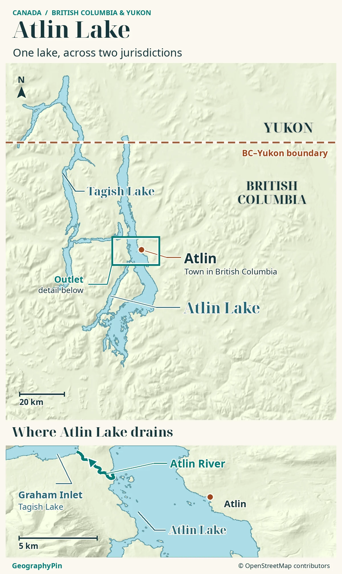
Atlin the community is on the eastern shore
Atlin is an unincorporated community in British Columbia, on the lake’s eastern side. Its name is a settlement label, not a point at the center of the whole lake. British Columbia’s official geographical names record places the community at approximately 59.58°N, 133.70°W; that is a general locator, not a particular dock or visitor entrance.
The community is south of the Yukon boundary. Seeing the name “Atlin” on a road map should therefore not be taken to mean that you have reached the lake’s Yukon shore.
The Taku River Tlingit First Nation’s 2021–2026 strategic plan identifies the community as Wenah and the lake as Aa Tlein. These names belong to a lived cultural landscape, not just a scenic backdrop. The northern province–territory boundary does not summarize Indigenous relationships with the lake.
Atlin’s waterfront is also a community water source. The First Nation’s source-protection information emphasizes the need to protect it from contamination associated with waterfront activities. A blue area on a map is simultaneously a lake, habitat and part of everyday community infrastructure.
The outlet is on the west side, not the far northern tip
Water leaves Atlin Lake through the Atlin River, which flows northwest into Graham Inlet of Tagish Lake. The British Columbia Geographical Names Office identifies that connection explicitly. The outlet is on the lake’s western side in British Columbia, not at the far northern end in Yukon.
Find Graham Inlet before drawing the drainage arrow
A lake can extend north of its outlet. Atlin is a useful example: the long northern arm and the downstream direction of the wider watershed are not enough to identify where water actually exits. On a map, look for the short river connection toward Tagish Lake rather than drawing an arrow straight through the northern shore.
Graham Inlet is part of Tagish Lake. It is not another name for Atlin’s northern arm. Keeping the inlet label attached to the receiving lake makes the connection much easier to follow.
| Step | Connection |
|---|---|
| Atlin Lake | Drains through the Atlin River. |
| Atlin River | Enters Graham Inlet, part of Tagish Lake. |
| Tagish Lake | Connects downstream through the Tagish River, also called Six Mile River. |
| Tagish River | Enters Marsh Lake. |
| Marsh Lake | Discharges into the Yukon River. |
This is a drainage sequence, not a boating itinerary. It explains why Atlin is described as part of the Yukon headwaters without calling Atlin Lake the Yukon River itself.
A deep, glacier-fed lake with inconsistent published area figures
The lake’s southern landscape includes the Llewellyn Glacier and rugged terrain within Atlin/a Téix’gi Aan Tlein Park. Meltwater and runoff connect the mountains with the lake. The surrounding relief is not just scenery: it directs runoff toward the lake and separates neighboring valleys.
Depth and surface area answer different questions
Yukon’s report on the 2014 survey, whose catalog record was updated in 2024, lists a maximum depth of about 928 feet (283 meters) and an average depth of about 281 feet (85.6 meters). These are the report’s lake characteristics, not a depth measured at every shore or a prediction of water level on a particular date.
| Source and date | Reported area | What was measured? |
|---|---|---|
| British Columbia, Lake Sampler, summer 2023 | About 299 sq mi (775 km²) | No boundary or measurement method stated for the figure. |
| Yukon Fish and Wildlife, 2014 survey; catalog record updated May 27, 2024 | About 227 sq mi (58,792 ha, equivalent to 587.92 km²) | The report describes a lake crossing the border, but does not say what shoreline or water areas were counted. |
The records do not give comparable footprints or methods, so they do not establish a British Columbia-only figure versus a whole-lake figure. Nor do the two numbers show that the lake changed size.
British Columbia identifies Atlin as its largest natural lake. That wording matters: it is not the same category as a ranking that includes reservoirs. A lake can also rank highly by surface area without being the longest or deepest.
Reaching the town is not the same as reaching the park
The town, the lake and the provincial park are not interchangeable destinations. BC Parks states that visitors cannot access the park by vehicle and must enter by boat or aircraft. A road reaching the community does not mean there is a road around the lake or into every southern inlet.
BC Parks also warns that this large, glacier-fed lake can develop high winds and rough water. A short line across an inlet on a small map can hide a much more demanding crossing. Check current conditions, appropriate equipment and local access information rather than treating a locator map as a route plan.
Likewise, a province–territory line does not show individual property access, protected-area boundaries or the rules for a particular activity. Those require their own current information. The map here explains where the lake and its outlet are; it does not certify a launch site, road condition, ice crossing or ferry service.
Frequently Asked Questions
Is Little Atlin Lake another name for Atlin Lake’s Yukon end?
No. Little Atlin Lake is a separately named nearby lake in Yukon. A search result, fisheries rule or campsite description for Little Atlin Lake should not be applied automatically to Atlin Lake.
Does the smaller area figure cover only the Yukon end?
The report does not say that. It describes the lake on both sides of the border and gives one area figure without a measured outline. Neither source is enough to calculate how much of the lake lies in each jurisdiction.
What Did We Learn Today?
Atlin Lake’s northern tip belongs to Yukon, but its community and river outlet lie farther south in British Columbia. Following the Atlin River toward Graham Inlet reveals the connection to Tagish Lake and the Yukon drainage. The boundary, shoreline and drainage route each answer a different geographic question.
Sources & Data Notes
Sources checked November 19, 2026. Depths are the characteristics listed in the 2014 Yukon survey report, not new soundings. Conflicting official surface areas are attributed rather than falsely reconciled. U.S. customary conversions are rounded. The community coordinate is a rounded official representative point, not a precise access point. No percentage split between jurisdictions or current transport schedule is asserted.
- BC Geographical Names: Atlin Lake
- BC Geographical Names: Atlin community locator
- BC Geographical Names: Atlin River and Graham Inlet
- Government of Yukon: report on the 2014 Atlin Lake survey (catalog record updated May 27, 2024)
- British Columbia: Lake Sampler, summer 2023
- Government of Yukon: Tagish River connection
- Government of Yukon: Tagish River entering Marsh Lake
- Environment and Climate Change Canada: Yukon River below Marsh Lake
- Taku River Tlingit First Nation: strategic plan 2021–2026, community and lake names
- Taku River Tlingit First Nation: Atlin waterfront source protection
- BC Parks: park geography, access limits and lake conditions
- Government of Yukon: Little Atlin Lake is a separate named fishery
Map: Original GeographyPin atlas using OpenStreetMap’s Atlin Lake, Tagish Lake and Atlin River centerline, retrieved November 19, 2026. © OpenStreetMap contributors, ODbL. Shaded relief: Mapzen/AWS Terrain Tiles and underlying elevation sources. The BC–Yukon line follows the 60th parallel at atlas scale; this is not a surveyed boundary map. The arrow indicates river flow, not a boating route.
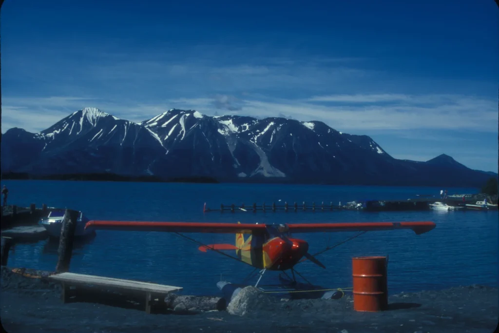
Photograph: Atlin, British Columbia, Jerrye and Roy Klotz MD, file dated October 7, 2008, CC BY-SA 3.0. Resized and converted to WebP without color alteration; derivative under the same license. The archival view does not establish current transport services.