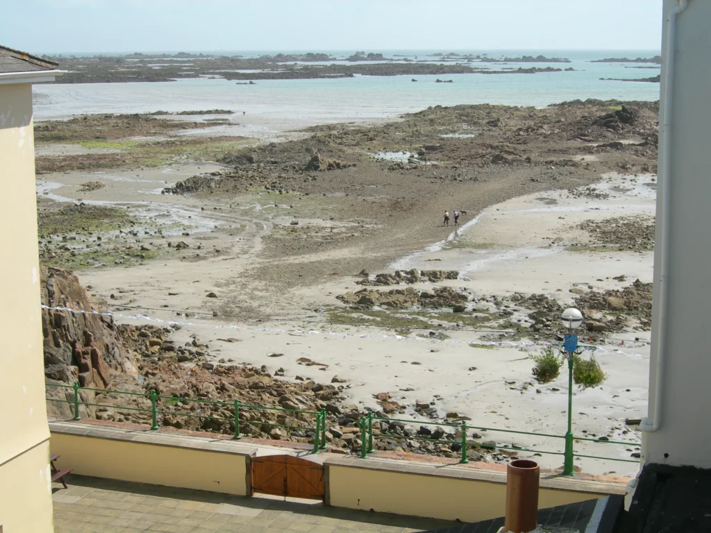
Jersey is close to Normandy, but its political relationship is with the British Crown. Its geography has another contrast: a high northern edge and a gentler descent toward the more populated south. Along the coast, large tides reveal reefs and sand that disappear beneath the sea again. Understanding the island means keeping its landforms, changing shore and constitutional boundaries separate.
Jersey is the largest Channel Island, near the French coast in the Bay of Saint-Malo. Its plateau slopes from northern cliffs toward southern bays. The Bailiwick of Jersey includes offshore reefs and is a self-governing Crown Dependency, not part of the United Kingdom or a British Overseas Territory.
How to use this article: Explore the plateau, understand the tidal shore, or clarify Crown Dependency status.
1. Where Is Jersey, and What Does the Name Include?
Jersey lies in the English Channel, about 14 miles (22 km) from the French coast and 85 miles (137 km) south of the English coast, according to the island’s government. St Helier, on the south coast, is its capital. Proximity to France explains its position on a map; it does not make Jersey part of France.
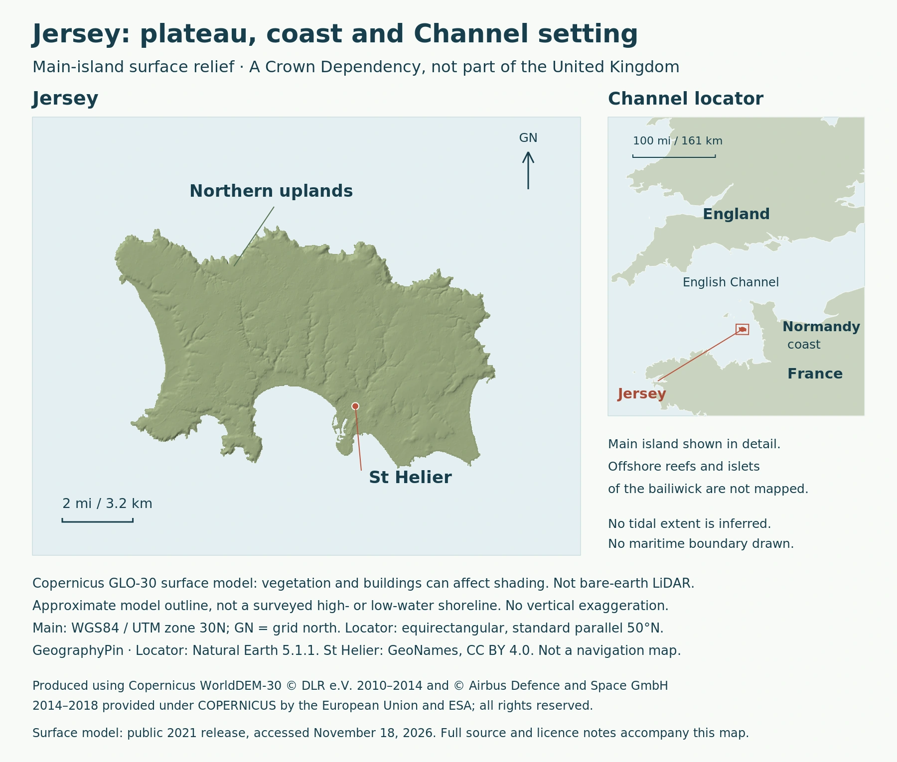
Three geographical labels help prevent confusion:
| Name | What it means |
|---|---|
| Island of Jersey | The main landmass containing St Helier and the island’s 12 parishes. |
| Bailiwick of Jersey | The jurisdiction, including the main island and offshore island and reef groups. |
| Channel Islands | The wider island group, including Jersey and the separate Bailiwick of Guernsey. |
The Écréhous lie northeast of the main island and the Minquiers to its south. These are not simply miniature versions of Jersey: small rocky islets rise above much larger reef platforms. At low water, their exposed surfaces become far more extensive. The bailiwick therefore cannot be understood from the main island’s outline alone.
2. A Northern Edge and a Southward-Sloping Plateau
Relief and the rural landscape
Jersey’s broad landform is asymmetrical. A Jersey Heritage farmstead study describes a steep northern side, a central plateau and a slope toward southern sandy bays and population centers. This is a regional pattern, not a claim that every field tilts the same way: the island has a varied local landscape within that larger shape.
The interior is also a worked landscape. Dispersed farmsteads, small fields and hedge banks are important parts of its rural character. The same study traces changes associated with cider, dairy farming and potatoes, showing how agriculture has reshaped farm buildings and land use over time. Jersey’s countryside is neither an untouched plateau nor a continuous urban area.
That contrast helps explain why a terrain map and a settlement map answer different questions. Relief shows the island’s physical framework; farms, roads and buildings show how people occupy it. Neither should be mistaken for the boundary of a parish or of the bailiwick.
3. Why the Shore Changes So Dramatically
Large tides and exposed reefs
The southeast coast’s Ramsar management plan describes a tidal range of about 39 feet (12 m). A tidal range concerns the vertical difference between high and low water, not the height of a breaking wave. The figure describes the scale of large tides, not a fixed rise and fall on every tidal cycle.
“Spring tide” is not a seasonal term. NOAA explains that spring tides occur around new and full moons throughout the year, when the Sun, Earth and Moon are approximately aligned and tidal ranges are generally larger. Neap tides have smaller ranges and occur around the quarter moons.
As water retreats, rock platforms, boulder fields, sand and shingle become exposed, with gullies and shallow areas between reefs. This creates a broad intertidal environment rather than a shoreline that stays in one place. A photograph taken near low water can consequently look very different from the same view near high water.
These shores are ecological habitats as well as visible landforms. The southeast coast includes seagrass areas and feeding habitat used by wintering shorebirds and wildfowl. Jersey’s government lists four Ramsar sites, covering the southeast coast and offshore reef groups. That designation does not mean every beach or every part of the main island is within a Ramsar site.
4. St Helier, Parishes and Population
A town is not the same as its parish
Jersey’s census counted 103,267 residents on March 21, 2021. This is a dated census total, not an estimate for the present year. Statistics Jersey reports that 35% lived in the parish of St Helier, followed by St Saviour at 13% and St Brelade at 11%.
Those percentages refer to parishes. The St Helier parish count should not be presented as though it measured only the compact town center. Jersey’s 12 parishes provide an administrative framework across both built-up and rural land.
The concentration in St Helier gives the southern capital a prominent place in the island’s human geography, while the census geography reminds readers that urban places and administrative areas are different units. Any comparison with another island needs matching definitions and dates, not simply two numbers both labeled “population.”
5. A Crown Dependency, Not Part of the UK
The constitutional distinction
Jersey is a self-governing Crown Dependency. Its constitutional connection is with the Crown, rather than membership of the United Kingdom. It has its own legislature, legal system and courts, and it is not represented in the UK Parliament.
The UK government expressly distinguishes Crown Dependencies from British Overseas Territories. Jersey belongs to neither the UK’s four constituent countries nor the Overseas Territory category. Nor should it be added as a sovereign state when counting countries on a world map.
Self-government does not mean that every responsibility is entirely separate. Jersey’s government explains that the UK has formal responsibility for defense and, to an extent, foreign affairs. The island also has a distinct international identity. These arrangements are more precise than calling Jersey simply “British” or “independent,” both of which leave important parts of the relationship unstated.
What Did We Learn Today?
Jersey combines a southward-sloping plateau, a populated southern coast and extensive shores exposed by large tides. The main island is only part of the bailiwick, and the Channel Islands are a wider group. Politically, Jersey is a self-governing Crown Dependency, distinct from both the UK and British Overseas Territories. Population figures need their census date and geographical unit attached.
Sources & Data Notes
Sources, dates and map conventions
Population and parish shares are from the March 21, 2021 census. The coastal explanation uses the southeast coast’s 2011 Ramsar management plan, not a tide forecast. The main-island map does not define the changing intertidal edge or the bailiwick’s complete maritime extent. Separate map and photograph credits identify their data and licenses.
Produced using Copernicus WorldDEM-30 © DLR e.V. 2010-2014 and © Airbus Defence and Space GmbH 2014-2018 provided under COPERNICUS by the European Union and ESA; all rights reserved. The organisations in charge of the Copernicus programme by law or by delegation do not incur any liability for any use of the Copernicus WorldDEM-30. Copernicus data licence. The map is an independent rendering, not an endorsement by the data providers.
- Government of Jersey: island location and parishes
- Jersey Heritage: historic farmstead study, 2008
- Government landscape appraisal: offshore reefs and islands
- Southeast coast Ramsar management plan, 2011
- Government of Jersey: Ramsar sites
- Statistics Jersey: March 21, 2021 census
- Government of Jersey: relationship with the UK
- UK Ministry of Justice: Crown Dependencies
- NOAA: tidal-range definition
- NOAA: spring and neap tides
Featured photo: Low tide at Havre des Pas, St Helier, August 2007. Christian Pinatel de Salvator, CC BY 3.0; resized and converted to WebP.
