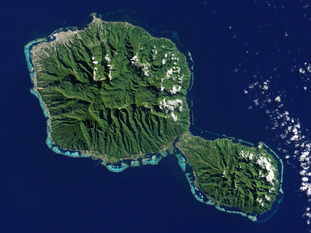
A photograph of Tahiti’s mountains and a map of a coral lagoon can both show French Polynesia, yet they describe very different landscapes. Understanding the territory begins with separating its five island groups from its best-known island and from the wider region called Polynesia.
French Polynesia is an autonomous French overseas collectivity in the South Pacific, comprising five geographic archipelagos: Society, Tuamotu, Marquesas, Austral and Gambier. Its landscapes include high volcanic islands and coral atolls. Tahiti is one island within it, while Polynesia is a much wider region; French Polynesia is not a sovereign state.
How to use this article: Separate the place-name scales, compare geographic and administrative groups, or examine high islands and atolls.
1. Where French Polynesia Is on the Map
Tahiti, French Polynesia and Polynesia are different scales
French Polynesia lies in the central South Pacific, between Australia and South America. It is a dispersed territory, not one large island. Tahiti belongs to the Society Islands and contains Papeete, the administrative capital.
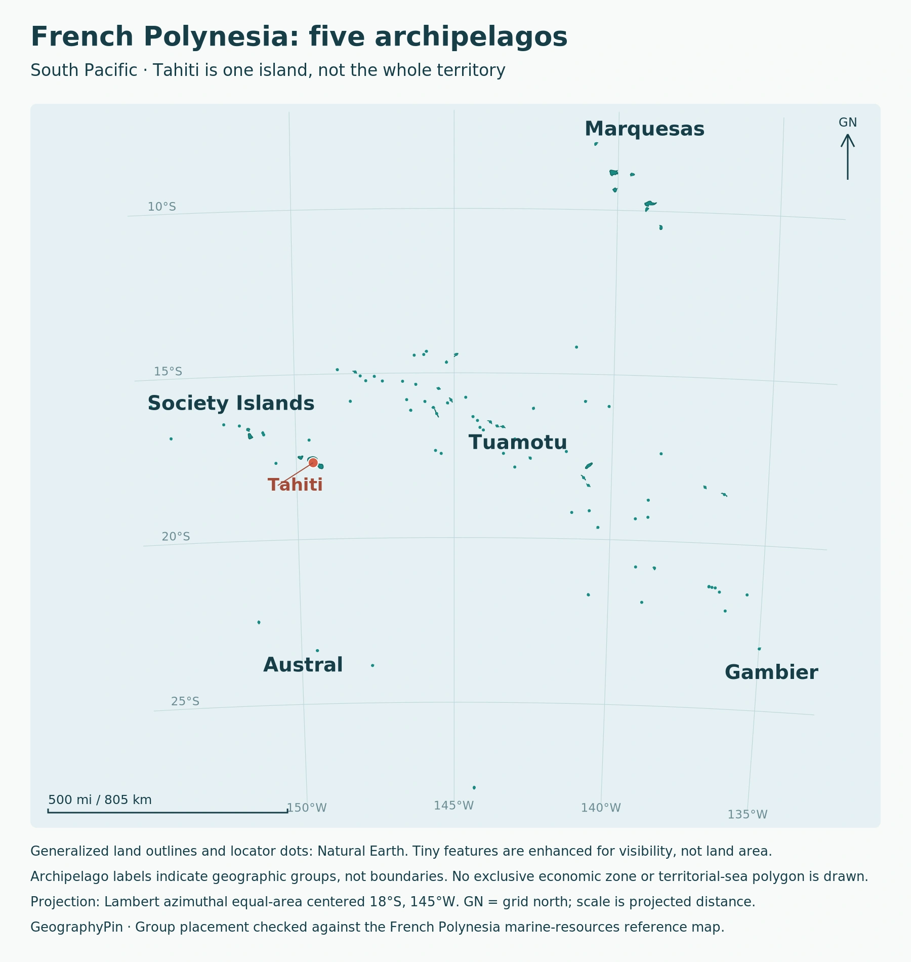
The names form a useful hierarchy: Papeete is a city; Tahiti is an island; the Society Islands are an archipelago; French Polynesia is a territory containing five archipelagos. None of those names means the entire Polynesian region.
New Zealand’s Te Ara encyclopedia describes the wider Polynesian triangle through Hawaiʻi, New Zealand and Rapa Nui. It includes places with different political relationships, not a single state administered from Tahiti. The Pacific Ocean overview supplies the wider ocean setting.
A regional locator is therefore more useful than enlarging Tahiti until it fills the page. The space between island groups is part of the geographic explanation, even though ocean and dry land are not interchangeable area measurements.
2. The Five Archipelagos
| Archipelago | Map position | Landscape distinction |
|---|---|---|
| Society Islands | Western part of the territory | Tahiti and other high islands alongside atolls; Windward and Leeward groups |
| Tuamotu | Broad northwest–southeast chain | Predominantly atolls; Rangiroa and raised Makatea show important variation |
| Marquesas | Northern group | Rugged high islands; Nuku Hiva and Hiva Oa are major reference points |
| Austral Islands | Southern group | High islands and reefs; not simply an extension of Tahiti |
| Gambier | Southeastern group | High islands within a reef-and-lagoon setting, with nearby atolls |
The local environment directorate’s geographic account distinguishes these five groups. The table describes their broad character; it does not claim every island in a group has the same shape or geology.
Why administrative tables use different labels
INSEE’s 2022 census table also has five administrative subdivisions, but they are not the same five units. It separates the Society Islands into the Windward Islands and Leeward Islands, while combining Tuamotu and Gambier.
Consequently, a statistic for “Tuamotu–Gambier” should not be assigned to the Tuamotu archipelago alone. Likewise, the Windward Islands are not another archipelago to add to the geographic five. Read the table’s unit before comparing its figures with a map.
3. High Islands and Coral Atolls
A mountain island and an atoll are different landscapes
High volcanic islands retain an exposed rocky interior. An atoll is organized around a reef and lagoon rather than a surviving central volcanic mountain. These forms help explain why a Tahiti landscape cannot represent every island in the territory.
USGS illustrates one classic developmental sequence: reefs grow around a volcanic island, the island subsides, and the reef continues growing near sea level. If the volcanic island disappears beneath the surface, a reef surrounding a lagoon can remain. This is a process model, not a claim that every island follows an identical timetable.
French Polynesia also shows why the simple “high volcano versus low coral ring” contrast needs qualification. Research summarized by LSCE in 2023 documents raised reef limestone in northwestern Tuamotu islands, including Makatea. Coral origin therefore does not guarantee that all exposed land sits close to sea level.
For map reading, distinguish the outline of dry land from the surrounding reef and the lagoon inside it. A broad lagoon does not imply an equally broad area available for roads, buildings or cultivation. A locator symbol can identify an atoll without reproducing those fine-scale boundaries.
4. Population Is Concentrated, Not Evenly Spread
The 2022 census reported 278,786 residents. ISPF’s analysis places 209,980 people in the Windward Islands, approximately three quarters of the territory’s population. These are dated census results, not a present-day population estimate and not a count for Tahiti alone.
The same study describes a concentrated urban zone on Tahiti extending from Punaauia to Mahina. Papeete’s municipal population is therefore not the population of the entire urban area, still less the population of French Polynesia.
This concentration matters when interpreting a territory-wide map. The five group names occupy large spaces on the page, but they do not represent five equally populated regions. A population distribution describes where people live; it cannot be inferred simply from the number of island dots.
The Economic Development Agency’s overview identifies Tahiti-Faa’a Airport as the international transport hub and describes domestic air connections. The geographic point is the network linking separated islands, not a promise that any particular route operates every day.
5. Status Within France and the UN Framework
French Polynesia is an autonomous overseas collectivity within the French Republic, not an independent sovereign state. Its particular institutional framework is established by the 2004 autonomy statute under Article 74 of France’s Constitution. It has its own president, government and elected assembly; France retains responsibilities including defence.
The phrase “overseas country,” used in descriptions of its status, must therefore be read within that French constitutional context. It does not make French Polynesia an additional sovereign-country entry in the world atlas’s stated country roster.
A separate international framework also matters. The UN General Assembly’s 2013 resolution recognized French Polynesia as a Non-Self-Governing Territory and affirmed its people’s right to self-determination. The UN Secretariat’s January 2026 working paper continues to describe it as administered by France.
Domestic autonomy and the UN decolonization classification answer different questions. Neither a tourism label nor a map color should be used to erase that distinction or imply that a future political outcome has already been decided.
Frequently Asked Questions
Is French the only language used?
No. French is the official language, while Polynesian languages remain widely spoken. A territory’s official-language designation should not be read as a complete description of the languages used by its communities.
Why do some census tables give 283,147 instead of 278,786?
INSEE distinguishes the 2022 municipal population from a legal total that includes people counted separately through another communal connection. The larger sum includes double counts across communes. This article uses the municipal-population total for the resident count.
What Did We Learn Today?
French Polynesia is best understood through scale: a city on Tahiti, five geographic archipelagos, a dispersed territory and a wider Polynesian region are not interchangeable. High islands and atolls explain contrasting landscapes, while administrative units and dated census figures explain settlement. Its French status and UN classification need their own terms, not assumptions drawn from the map.
Sources & Data Notes
Sources, dates and map conventions
Population and distribution use the 2022 census, not a current estimate. The five-group geographic scheme is distinct from census administrative subdivisions. Island and land-area totals vary among official summaries, so no universal total is asserted here. The original locator uses public-domain Natural Earth land geometry, with group placement checked against the local marine-resources reference map. Generalization can omit small features; locator dots and polygon fragments are not an island census. No maritime boundary is drawn. The featured Landsat image shows Tahiti in 2001, not current development or the entire territory.
- French Polynesia DIREN: the five archipelagos
- Economic Development Agency: French Polynesia overview
- USGS: Atoll development
- LSCE: research on uplifted northwestern Tuamotu atolls, 2023
- ISPF: the 2022 population census, publication 1396
- INSEE: 2022 administrative-subdivision population table
- French government: French Polynesia’s particular status
- UN Secretariat: French Polynesia working paper, January 2026
- UN General Assembly: resolution 67/265 on self-determination, 2013
- Te Ara: Pacific neighbours and the wider Polynesian region
Featured image: Tahiti, one island in French Polynesia, on July 11, 2001. NASA Earth Observatory image by Jesse Allen and Robert Simmon, using USGS Landsat data; resized.