Turkmenistan combines a broad desert interior with irrigated river corridors, mountain foothills and a Caspian coastline. The key to its settlement pattern is not simply where rain falls: water is also carried through rivers, canals, wells and local storage systems.
Turkmenistan is a landlocked country in Central Asia, with Ashgabat as its capital. The Karakum Desert dominates the interior, the Kopet Dag rises along the southern border, and the Caspian Sea lies to the west. Rivers and irrigation canals sustain major farming areas, while desert communities also depend on groundwater and stored rainfall.
How to use this article: Locate the country on the map, read the physical map, explore regional climates, or check the population reference.
1. Locate Turkmenistan and Its Capital
Central Asia’s southeastern Caspian shore
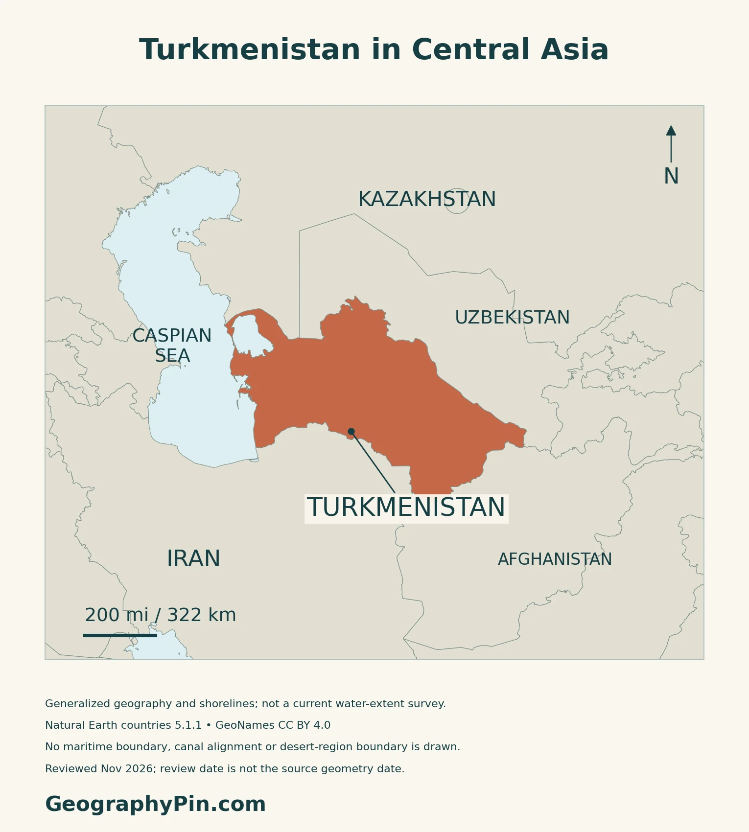
Turkmenistan is a country in Central Asia, with a western coast on the Caspian Sea. Its land neighbors are Kazakhstan to the north, Uzbekistan to the northeast and east, Afghanistan to the southeast and Iran to the south. The Caspian is an enclosed inland water body, not an open-ocean coast.
Ashgabat is the capital; Arkadag is a separate city
Ashgabat lies near the Kopet Dag foothills in southern Turkmenistan. Article 24 of the Constitution names it as the national capital. Arkadag, a separate planned city, received special status as a city of state significance under a law that took effect on March 24, 2023. That designation did not replace Ashgabat as the capital.
2. Read the Desert, Foothills and Coast
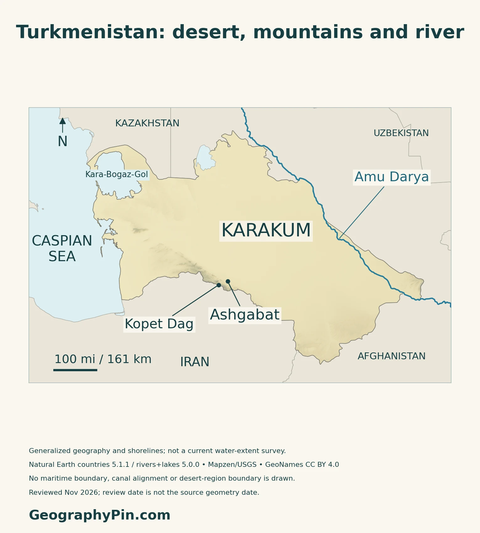
Four landscapes organize the country
| Setting | Physical character | Settlement and land use |
|---|---|---|
| Karakum interior | Broad arid plains, sand and other desert surfaces | Pastoral communities and widely separated settlements |
| Kopet Dag and southern foothills | Mountain margin along Iran | Ashgabat and foothill settlements |
| River and oasis corridors | Amu Darya margins and southern irrigated fans | Concentrated fields, canals and towns |
| Caspian coast | Inland sea, bays and saline lowlands | Ports, industry and a changing water edge |
Desert does not mean one unbroken surface of dunes
The Karakum occupies most of the country, but the landscape is not uniform. UNESCO’s Cold Winter Deserts of Turan property recognizes varied desert ecosystems across Turkmenistan, Kazakhstan and Uzbekistan, including communities adapted to intense summer heat and winter cold. Its selected protected components do not designate every part of the Karakum.
A 2024 UNDP field-based report describes the Bokurdak area of the Central Karakum as sandy plains with saxaul groves and desert pastures. Sheep and camel husbandry depend on access to water as well as grazing land. Wells and rainfall collection serve a different pattern of land use from the irrigated crop fields of the oases.
Mountains and the Caspian interrupt the desert pattern
The Kopet Dag forms a mountain margin along Iran. Farther east, the Koytendag range on the Uzbek border is a separate upland setting.
At the opposite side of the country, the Caspian Sea is a vast enclosed water body rather than an arm of the ocean. The shallow Kara-Bogaz-Gol lagoon receives Caspian water through a narrow connection and loses water through evaporation, concentrating salts.
3. Why Climate and Water Availability Differ
Hot summers can coexist with cold winters
The World Bank–ADB 2021 climate profile describes long, hot, dry summers and a strong continental seasonal cycle. Northern areas generally have colder, longer winters than the south. Summer temperatures along the Caspian coast are somewhat moderated compared with the interior.
Most rainfall comes in the cooler part of the year, with very little during summer in many areas. The Kopet Dag receives more precipitation than the desert lowlands. The profile’s monthly climate figure uses 1991–2020, while its spatial maps use 1991–2019; these describe climatic patterns, not current weather.
A shoreline is a dated observation, not a fixed line
USGS explains that Kara-Bogaz-Gol responds to fluctuations in the Caspian because the two are connected. The lagoon’s shallow form and strong evaporation make its water balance quite different from that of a deep ocean coast.
The maps here use generalized reference outlines. For a separate, dated satellite comparison rather than an assumed present-day coastline, see the Caspian Sea shrinking map.
4. Water Networks, Farming and Energy
The Amu Darya and Karakum Canal are not the same waterway
The Amu Darya is a natural transboundary river. The Karakum Canal is an engineered diversion carrying some of its water across southern Turkmenistan.
NASA’s account of a June 2021 astronaut photograph shows irrigated fields on the Murgab and Tejen fans, with Mary among the cultivated land. River water and the Karakum Canal support these farming landscapes.
Connections also extend across national borders. Uzbekistan’s water ministry describes shared infrastructure serving the Amu Darya corridor and Dashoguz, including the Tuyamuyun reservoir system. Water-source geography and the operation of waterworks therefore cannot be understood from national borders alone.
Delivery and drainage matter as much as diversion
Water withdrawn from a river is not identical to water delivered to a field. UNDP’s water-efficiency program identifies conveyance losses, pumping energy and land salinization as linked management concerns.
The 2024 local-adaptation report documents another part of the problem: excessive irrigation and poor drainage can raise mineralized groundwater toward crop roots. Its examples include more careful water distribution, field leveling and drip irrigation.
Natural gas adds another pattern of land use
Farming is not the country’s only resource-based activity. The U.S. International Trade Administration’s January 2026 guide identifies major onshore natural-gas fields, including Galkynysh, and oil and gas activity around the Caspian. Extraction, processing facilities and transport connections create economic nodes beyond the oasis farming belts.
5. Dated Country Facts and Institutions
| Item | Reference | Date or scope |
|---|---|---|
| Capital | Ashgabat | Constitution, Article 24 |
| Population | 7,057,841 | Officially reported 2022 census; reference December 17 |
| Surface area | About 188,456 sq mi (488,100 km²) | UN reference, 2023; not land-only |
| State language | Turkmen | Constitution, Article 21 |
| Currency | Turkmenistan manat (TMT) | Current currency code in UNData |
| Government | Presidential republic | Constitutional form |
| Administration | Five velayats: Ahal, Balkan, Dashoguz, Lebap and Mary | Ashgabat is the capital; Arkadag has special state-significance status |
What the official census figure describes
The census reference was midnight at the start of December 17, 2022; enumeration continued through December 27. The Statistics Committee defines the total as people residing in the territory. The table reports that published census result, not a 2026 headcount or a count of all citizens abroad.
UNData separately gives a 2025 medium-fertility population projection. A projection and a census observation have different reference dates and methods and should not be presented as the same measurement.
Language, administration and area conventions
Turkmen has constitutional state-language status, while citizens are guaranteed the right to use their mother tongue. Teaching or using other languages does not give them that same legal designation.
The five velayats are provincial units, subdivided into etraps, or districts. Arkadag’s special status is a separate legal category, so the 2022 census’s regional breakdown should not be mistaken for a current administrative map.
The area table follows the UN’s dated surface series. The Foreign Ministry also reports about 189,657 sq mi (491,210 km²); the difference is not identified here as land versus water.
What Did We Learn Today?
Turkmenistan’s geography links the Karakum interior with foothills, oases and the Caspian coast. Water reaches settlements in several ways: rivers, engineered canals, wells and local storage. Those systems help explain farming and pastoral land use, while natural gas creates a separate network of extraction and processing activity.
Sources & Data Notes
The official population count retains its 2022 census date rather than being presented as a current estimate. Area figures follow their stated source and definition. FAO’s historical survey supports broad landforms, not old administrative units, population or water-use statistics. Climate references retain their baseline periods. NASA’s farming example describes a 2021 photograph, and UNDP’s 2024 report documents selected local practices. The UNESCO desert property consists of protected components, not the entire Karakum. Reference water outlines are not current shoreline surveys.
- State Statistics Committee: official 2022 population and housing census results
- State Statistics Committee: 2022 census introduction
- State Statistics Committee: census reference time and population definitions
- UNData: Turkmenistan surface area, 2023, and separately identified population projection
- TURKPA legislative database: Constitution of Turkmenistan, Articles 1, 21 and 24
- Foreign Ministry: current general information and administrative units
- Foreign Ministry: Arkadag law and commencement, March 2023
- FAO: Irrigation in Central Asia, AQUASTAT Survey 2012, Turkmenistan physical setting
- UNESCO: Cold Winter Deserts of Turan, selected transnational components
- UNDP: Local adaptation practices in Turkmenistan’s water and agriculture sectors (2024), field-based report
- World Bank–ADB: Turkmenistan Climate Risk Country Profile (2021)
- USGS: Kara-Bogaz-Gol and its connection with the Caspian
- NASA Earth Observatory: Agriculture Fans Out in Turkmenistan, 2022 account of June 2021 imagery
- Uzbekistan Ministry of Water Resources: shared Amu Darya infrastructure, November 2025
- UNDP: Water-efficiency project, conveyance, pumping and salinization
- U.S. International Trade Administration: Turkmenistan oil and gas geography, January 2026
Map method: Original GeographyPin maps use public-domain Natural Earth countries 5.1.1 and rivers/lakes 5.0.0. All three country components are retained. Caspian, Kara-Bogaz-Gol and Sarygamysh outlines are generalized source geometry, not current water extent or a change comparison. The Amu Darya follows selected supplied river geometry, not a complete drainage network; no Karakum Canal or maritime boundary is drawn. GeoNames coordinates are credited under CC BY 4.0; Karakum and Kopet Dag labels are geographic references, not regional boundaries. Real Mapzen Terrain Tiles supply relief with Mapzen/USGS and upstream credits. Coherent below-sea-level terrain is preserved; isolated negative raster spikes are transparent, not replaced with invented heights. WGS84 scales apply at their displayed latitude. The cover uses the Commons Turkmenistan flag rendition under its public-domain/CC0 terms, with a separate complete flag for editorial identification.