A map of the Dominican Republic shows more than a beach-lined country: mountain belts divide its interior into valleys with different rainfall, river systems and settlement patterns. Understanding those contrasts starts with separating the country from Hispaniola, the larger island it shares with Haiti.
The Dominican Republic is a Caribbean country occupying eastern Hispaniola and nearby islands, with Haiti to the west and Santo Domingo as its capital. Its geography combines the high Cordillera Central, the broad Cibao Valley, coastal plains and the below-sea-level Enriquillo basin. Mountains help explain why wet forests and dry landscapes occur within the same country.
How to use this article: Locate the central mountains, compare wet and dry slopes, understand Lake Enriquillo, or check what Santo Domingo statistics cover.
1. Where the Dominican Republic Is
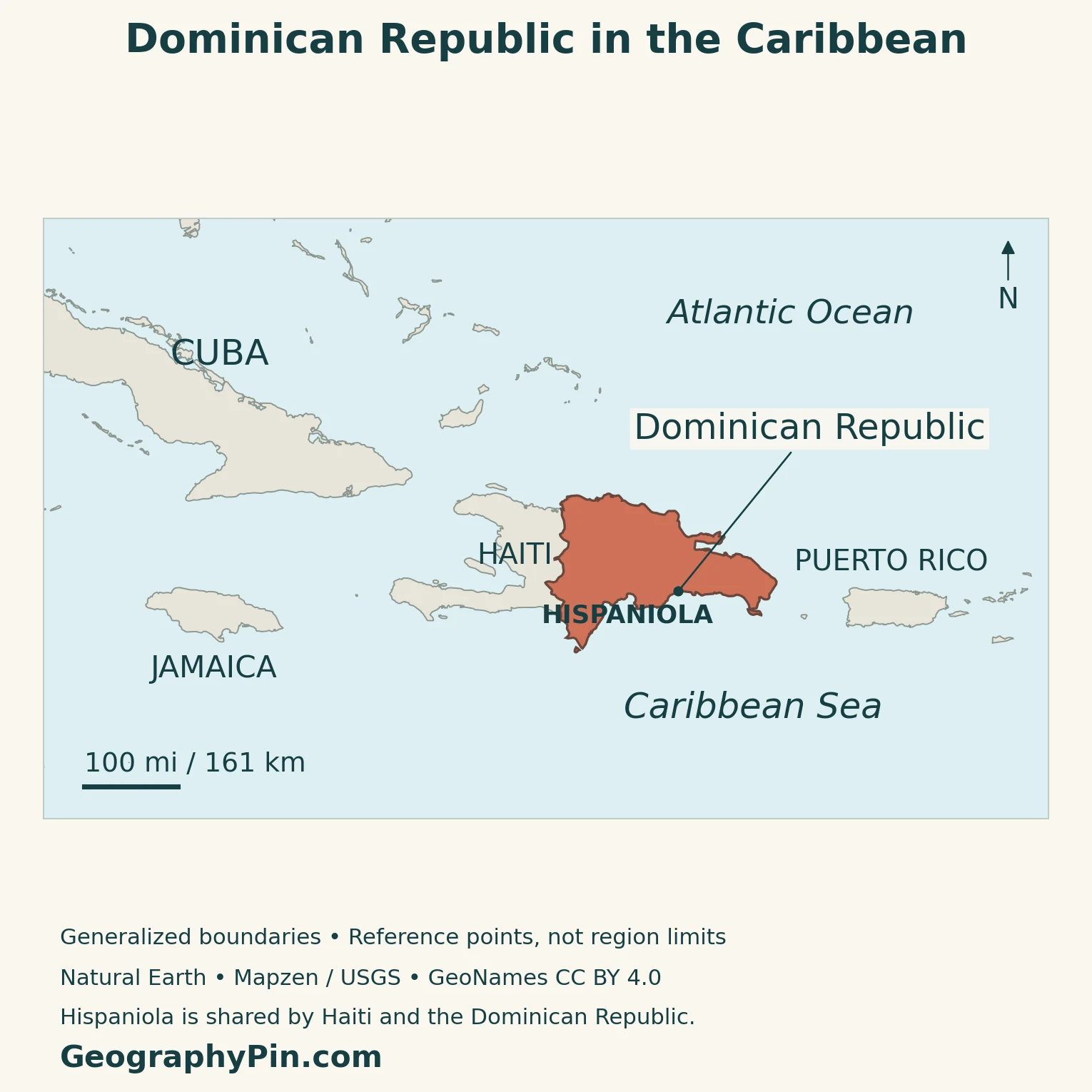
The Dominican Republic lies in the Greater Antilles, between Cuba to the northwest and Puerto Rico to the east. The Atlantic Ocean borders its northern coast, while the Caribbean Sea lies to the south. The Mona Passage separates eastern Hispaniola from Puerto Rico.
Haiti is its only land neighbor. The international boundary divides one island between two sovereign states; neither country occupies the whole of Hispaniola. In Spanish, the island is also called La Española. The country’s official name is República Dominicana.
Reading the country and island together
Start with the border, then locate Santo Domingo on the south coast and the mountains farther inland. Offshore islands, including Saona near the southeastern tip, are part of the Dominican Republic too. A country outline is therefore not quite the same thing as the outline of its main landmass.
The Caribbean countries and territories map puts Hispaniola within the wider island chain. In the conventional continental grouping, the country belongs to North America, not South America; the North American countries and capitals list includes the Caribbean states.
2. Mountains and Valleys Organize the Interior
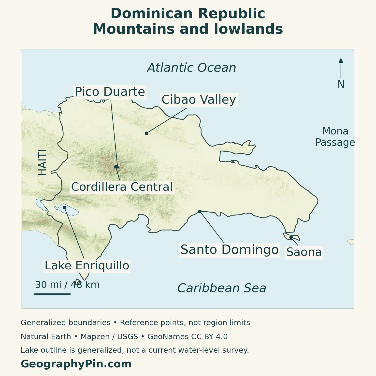
The Cordillera Central and Pico Duarte
The Cordillera Central forms the country’s principal highland mass. It contains Pico Duarte, the highest summit in the Caribbean, rising to roughly 10,100 feet (3,100 meters). Official reference pages differ on the exact summit elevation, so a rounded figure is more defensible here than treating one reported meter value as uncontested.
These mountains are not simply a backdrop to coastal places. They separate drainage basins and create substantial changes in temperature over relatively short distances. Mountain forest environments include pine and cloud forest, unlike the warm lowland landscapes familiar from coastal photographs.
The Cibao is a valley corridor, not a mountain range
North of the Cordillera Central, the Cibao Valley lies between that range and the Cordillera Septentrional. Santiago de los Caballeros is an important inland urban center within this northern region. The valley contains agricultural land and river corridors, but it is not uniformly wet: conditions in the northwest are drier than those farther east.
Other ranges and depressions complicate the picture. The southwest includes the Sierras de Neiba and Bahoruco, with the Enriquillo basin between them. Eastern and southeastern lowlands differ again from the high central interior. “Mountainous” is a useful first description of the country, not a claim that every district has the same terrain.
| Landscape | Physical setting | What it helps explain |
|---|---|---|
| Cordillera Central | High ridges and mountain valleys | Cooler uplands and major river headwaters |
| Cibao Valley | Interior corridor between northern and central ranges | Agriculture, Santiago and east–west contrasts in rainfall |
| Enriquillo basin | Low depression in the southwest | An inland saline lake below sea level |
| Southern and eastern coastal plains | Lower terrain beside the coast | Santo Domingo and important coastal development |
| Northern coast and Samaná area | Atlantic-facing coast, hills and peninsula | Different exposure to moisture and waves from the south coast |
These are explanatory landscape groups, not the country’s legal administrative divisions. Provincial boundaries can cross more than one landform.
3. Why Rainfall and Temperature Vary
The Dominican Republic has a tropical setting, but a national average conceals important differences. Elevation lowers temperatures, and the direction a slope faces affects how much moisture it receives. A mountain settlement and a coastal resort need not have the same conditions on the same day.
Windward slopes and drier sheltered areas
Northeasterly trade winds bring moisture toward the island. Where moist air rises over mountains it cools, encouraging clouds and precipitation. Some sheltered areas receive less rain after air has crossed higher ground: this is the rain-shadow effect.
Research in the Cordillera Central documents the relationship between local climate and the arrangement of its forests. Research in the western Cibao likewise shows why a relatively dry valley can still support farming along a river supplied from wetter highlands. Rainfall where a crop grows and rainfall in the river’s upstream catchment are different parts of the same water system.
The northeast and exposed slopes tend to be wetter than dry parts of the northwest and southwest. Seasonal rainfall also varies by location, so one simple “wet season” calendar should not be applied equally to every coast and mountain valley.
Tropical storms and hurricanes can produce damaging rain, flooding and coastal impacts. A geography profile explains that exposure; it is not a current storm forecast. National averages and the absence of rain at a particular beach cannot establish conditions in an upstream watershed.
4. Rivers and the Changing Enriquillo Basin
Many rivers carry water from the interior toward the coast. The Yaque del Norte links the Cordillera Central with the northwestern lowlands, while the Yuna drains toward Samaná Bay. Farther south, the Ozama meets the sea at Santo Domingo. Their different directions show why the island should be read as several watersheds rather than a single slope toward one coast.
Why Lake Enriquillo is different
Lake Enriquillo lies in a southwestern depression below sea level. Its basin is endorheic: surface drainage leads inward rather than continuing through a river outlet to the sea. Water loss by evaporation and changes in inflow influence both the amount of water and its salt concentration.
Its shoreline is not fixed. Satellite observations documented substantial expansion during the 2000s and early 2010s, when rising water inundated farmland and homes. Those observations describe a particular period, not proof that the lake is still expanding at the same rate today.
For that reason, this profile does not present an old lake area, water-level elevation or salinity as a timeless current measurement. A map outline should also be understood as a dated representation, especially around a lake whose extent has changed markedly.
The contrast with a river basin is useful: a highland watershed can move water downstream to the sea, while a closed depression retains inflowing water until it evaporates or leaves through other pathways. Both respond to weather, but the visible results can be very different.
5. People, the Capital and Country Facts
The 2022 national census counted 10,773,983 residents. This is a census result for 2022, not a live population counter. A separate UN medium-fertility projection lists about 11.52 million for 2025; differences between those totals reflect their reference dates and methods, not two interchangeable census counts.
Santo Domingo and the National District
Santo Domingo de Guzmán is the capital and seat of national government in the National District. The surrounding urban area extends into neighboring municipalities, so “Santo Domingo population” can describe several different areas. The National District alone is not the entire metropolitan settlement.
The 2022 census counted 1,029,110 people in the National District. Keep that geographic unit separate from Santo Domingo Province and from any broader metropolitan estimate. Santiago is another major population and economic center, giving the country’s urban geography a strong inland focus as well as a coastal one.
The capital’s historical core is located by the mouth of the Ozama River. Its Colonial City is a World Heritage property, but that designated historic area is only a small part of the modern city. The river-mouth setting connects the early port city to the much larger settlement that developed around it.
| Item | Fact |
|---|---|
| Capital | Santo Domingo de Guzmán, in the National District |
| Population | 10,773,983 residents, 2022 census |
| Area | About 18,704 square miles (48,442 square kilometers), national geographic institute reference |
| Official language | Spanish, under Article 29 of the 2024 Constitution |
| Currency | Dominican peso (DOP) |
| Government | Unitary republic; the president is head of state and government |
| Administrative framework | 31 provinces and the National District |
| Island and land neighbor | Eastern Hispaniola; Haiti to the west |
The area above follows the national geographic institute’s published reference. Other statistical series differ: UNData lists 18,792 square miles (48,671 square kilometers) with a 2023 reference year. Those figures should not be silently mixed in density calculations, nor should their difference be assumed to equal the country’s inland-water area.
6. Economic Geography Beyond the Beach Resorts
Coastal tourism is prominent, but the national economy is not simply a collection of resorts. Services, industry, agriculture and mining all contribute. Recent economic assessments identify tourism and gold exports among important external connections, alongside investment and remittances.
Santiago’s tobacco and cigar-making traditions illustrate an inland economic geography. Agricultural valleys and highland catchments also connect rural production to urban markets. In the east, beach destinations such as Punta Cana rely on international transport links, whereas Santo Domingo combines national administration with the functions of a large city.
These places are connected rather than isolated economic compartments. A coastal visitor economy needs water, energy, workers and supplies; agricultural production depends on transport and water management; urban expansion changes demand for both. The relationship between highlands, valleys and coast therefore matters beyond the physical map.
Climate exposure is part of that relationship. Flooding, heat and damage to coastal ecosystems can affect housing, transport, agriculture and tourism. Protecting watersheds and improving the reliability of water and energy services are development questions as well as environmental ones.
Frequently Asked Questions
Is Dominica the same country as the Dominican Republic?
No. Dominica is a separate country in the Lesser Antilles, between Guadeloupe and Martinique. The Dominican Republic is on Hispaniola in the Greater Antilles. Their similar English names do not identify the same island, government or capital.
Is Punta Cana the capital?
No. Santo Domingo is the capital. Punta Cana is a tourism destination in the eastern part of the country. It is useful to distinguish a prominent visitor destination from the place where the national government is based.
What Did We Learn Today?
The Dominican Republic is best understood through the relationships between its mountains, valleys and coasts. The central highlands shape drainage and local climate, the Cibao connects agriculture with an inland urban center, and Enriquillo illustrates how a closed basin behaves differently from rivers flowing to the sea. Distinguishing the country from Hispaniola, and the National District from greater Santo Domingo, makes its maps and statistics much clearer.
Sources & Data Notes
Population counts refer to the 2022 census; the separate 2025 UN figure is a projection. National area follows IGN (48,442 square kilometers), while UNData reports a different surface-area series. Pico Duarte is rounded because IGN lists 3,101 meters and the tourism ministry 3,087 meters. No current lake-level or salinity value is asserted. Historical country-study material supports stable landforms, not present-day demographics or economic performance.
- Ministry of Environment: Yuna River and its Samaná Bay outlet
- Ministry of Tourism: Punta Cana in the eastern Dominican Republic
- Instituto Geográfico Nacional: national area, administrative divisions and landform reference
- ONE: General Report of the 2022 Population and Housing Census, national and National District counts
- UNData: country profile, dated population projection and surface-area series
- 2024 Constitution: Articles 7, 13, 29, 122 and 229
- Ministry of Tourism: Pico Duarte and highland setting
- Library of Congress Country Studies: physical regions and drainage; historical edition used only for stable geography
- Martin and Fahey (2014): mesoclimatic patterns in the Cordillera Central
- Hooghiemstra and colleagues (2018): physical and agricultural setting of the Yaque River valley
- NASA JPL (2017): satellite evidence of Lake Enriquillo expansion
- Ministry of Environment: watersheds and the closed Enriquillo basin
- UNESCO: Colonial City of Santo Domingo and its Ozama river-mouth setting
- World Bank: economic overview
- World Bank: Climate and Development Report overview
- Ministry of Tourism: Santiago and its tobacco industry
- Ministry of Tourism: southeastern coast and nearby islands
Map method: Original GeographyPin cartography uses public-domain Natural Earth country, coastline and lake geometry. The maps do not show maritime boundaries. Lake Enriquillo’s outline is generalized, not a current water-level survey. Reference labels use GeoNames coordinates under CC BY 4.0, reprojected and rendered as labeled points rather than regional boundaries. Relief derives from Mapzen Terrain Tiles with USGS SRTM/GMTED2010 elevation. Elevation colors represent height, not vegetation. The featured image uses a flag-filled Natural Earth country outline beside an intact national flag; it is decorative cartography, not a maritime jurisdiction map.