Guyana’s Atlantic coast and its forested interior tell two different stories about the same country. Georgetown and much of the population occupy the northern coastal zone, while rivers connect inland forests, waterfalls and the southwestern Rupununi savannas. Understanding that contrast also helps explain how a mainland South American country developed such strong Caribbean connections.
Guyana is geographically South American because it lies on the continent’s northern mainland, bordering Venezuela, Brazil and Suriname. Its Caribbean identity reflects historical, linguistic and institutional connections rather than an island location. English is the official language, and Georgetown hosts the CARICOM Secretariat. Inland, the Guiana Shield and river systems give the country a distinct continental landscape.
How to use this article: Explore the Rupununi landscape, understand coastal drainage, or check the territorial-claim context.
1. Where Is Guyana?
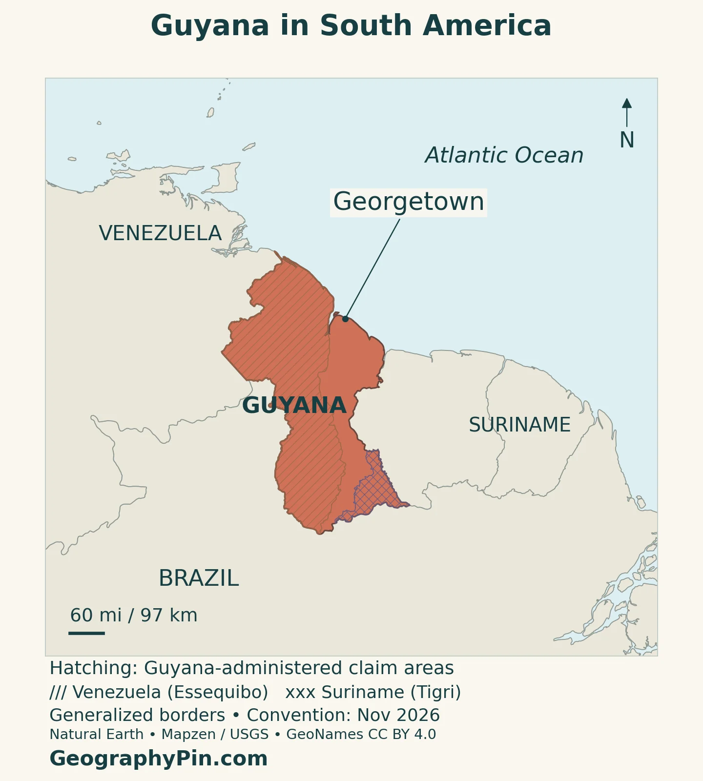
Guyana faces the Atlantic Ocean on the northern edge of South America. Venezuela lies to the west, Brazil to the south and southwest, and Suriname to the east. Georgetown stands near the mouth of the Demerara River, where the national capital meets the coastal lowlands. It is not an island, and its ocean frontage is Atlantic rather than a coastline directly on the Caribbean Sea.
The name Guyana refers to the sovereign country. The broader Guianas and Guiana Shield describe larger regional and physical settings extending beyond its borders. These names are related, but they are not interchangeable national boundaries.
Reading the territorial claims
The maps distinguish administration from territorial claims. The Essequibo area is administered by Guyana and claimed by Venezuela; hatching identifies that claim without removing the area from Guyana’s administered outline. In the International Court of Justice case concerning the 1899 arbitral award, public hearings on the merits concluded on May 11, 2026. At the November 16, 2026 check, the Court’s case page did not list a final judgment on the merits.
The river name and the disputed territory should also be kept separate: the Essequibo is a river system, while the claim concerns a wider territory west of it. A generalized map cannot settle the legal dispute or substitute for the Court’s documents.
The smaller Tigri, or New River Triangle, area is also administered by Guyana and claimed by Suriname. Its separate hatching identifies a different dispute, not an extension of the Essequibo claim.
2. Guyana’s Country Facts and Population
| Fact | Detail |
|---|---|
| Capital | Georgetown |
| Population estimate | 956,044 at December 31, 2024, Bureau of Statistics estimate in the preliminary 2022 census report |
| Census benchmark | 878,674 at September 15, 2022; preliminary total including census coverage adjustments |
| Surface area | About 83,000 square miles (214,969 km²), UNData surface-area series, reference year 2023; not land-only |
| Official language | English; Guyanese Creole and Indigenous languages are also used |
| Currency | Guyana dollar (GYD) |
| Administrative structure | 10 administrative regions |
| Government | Republic with an executive president and a National Assembly |
The census benchmark and the later estimate answer different questions. The first describes the population at the census reference date, including adjustments for households not contacted. The end-2024 estimate carries that base forward using births, deaths and migration information. Neither should be relabeled as an observed population count for 2026.
Area figures also depend on the statistical definition. The surface-area value above retains the UN series rather than combining it with a different national land-area figure. It is not a measurement of the claim hatching on the maps.
3. From Coastal Plain to Rupununi Savanna
Guyana’s physical geography is more varied than an uninterrupted blanket of rainforest. The national lands commission distinguishes four broad natural regions. These are landscape groupings, not the same units as the ten administrative regions.
| Region | Landscape | Geographical significance |
|---|---|---|
| Low coastal plain | Flat northern lowlands with clay, peat and sandy deposits | Settlement, farming and drainage infrastructure concentrate here |
| Hilly sand and clay region | An inland belt of sandy and clay-rich terrain | A transition beyond the coast, associated with bauxite and forest activities |
| Hinterland forest | Forested uplands and mountain ranges, including the Pakaraima and Kanuku settings | Relief and river valleys shape habitats and access |
| Rupununi savanna | Southwestern grassland, scrub and scattered woodland | An open landscape divided broadly into northern and southern parts by the Kanuku Mountains |
Why the Rupununi Looks Different
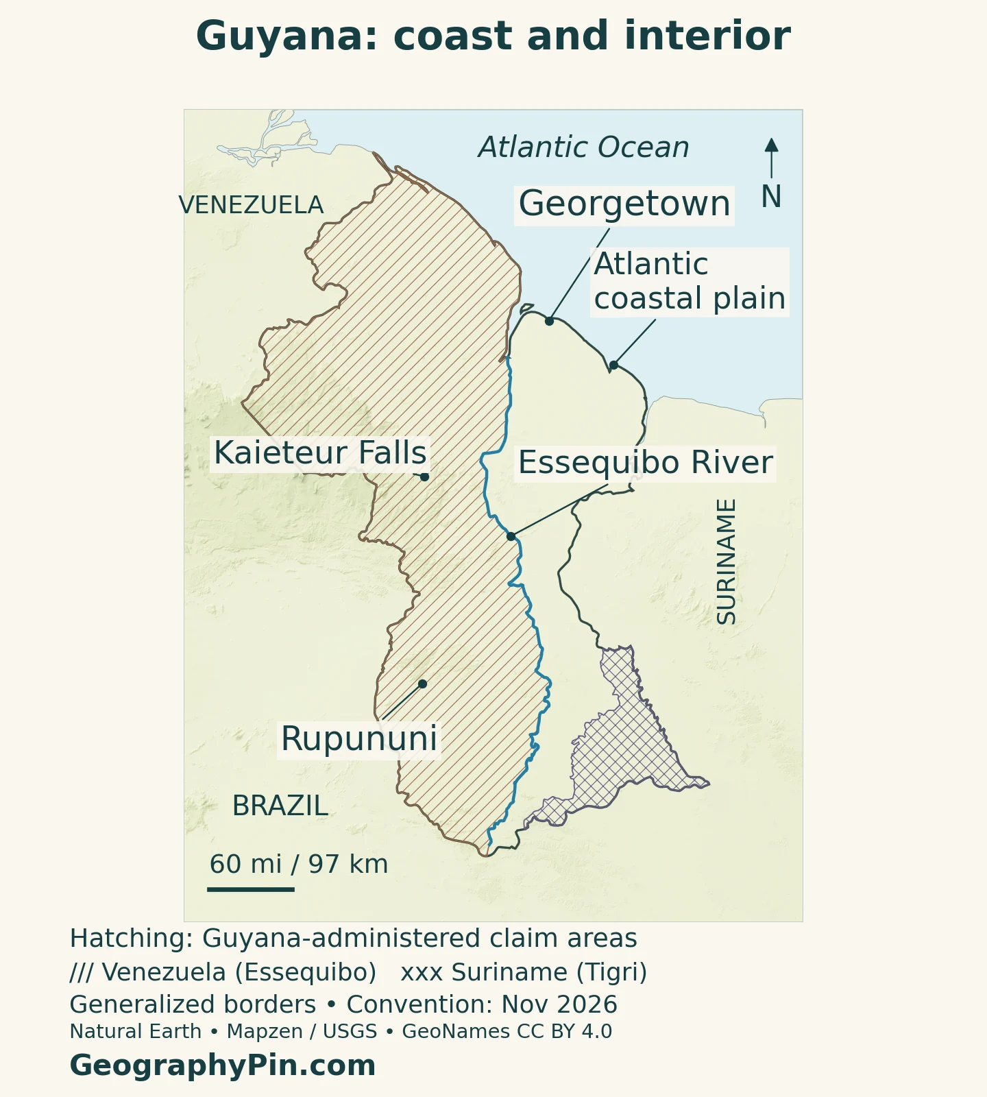
The Rupununi is a useful counterpoint to the forested uplands. Its open vegetation creates a different landscape from the coast or the wooded interior, and cattle raising and farming form part of its land use. A green country symbol on a small atlas map can conceal this contrast. The physical map instead identifies the savanna as a broad reference area rather than drawing an invented, sharply defined ecological boundary.
The Guiana Shield is the wider geological and landscape setting of much of the interior. Its uplands do not form a single uniform plateau: forested ridges, valleys and locally steep escarpments create substantial changes over comparatively short distances. Kaieteur provides a particularly clear example of how relief affects a river.
4. Rivers, Kaieteur Falls and the Interior
The Essequibo, Demerara, Berbice and Corentyne are major northward-draining rivers reaching the Atlantic. The Essequibo system gathers water from tributaries including the Potaro, Mazaruni, Cuyuni and Rupununi. Tracing those connections is more informative than treating each river as an isolated blue line.
Not every part of Guyana follows that same drainage direction. The Takutu–Ireng system connects to the Amazon basin through the Rio Branco and Rio Negro in Brazil. National borders and drainage divides therefore do not coincide everywhere. A watershed describes where water flows; it is not necessarily the same thing as a political territory.
Kaieteur: A Waterfall Within a River System
Kaieteur Falls drops about 741 feet (226 meters) on the Potaro River. Its setting combines a steep gorge, forest and a plateau edge within the Pakaraima Highlands. Spray from the falls supports a narrow belt of moist habitat near the gorge, while the drop also forms a barrier to fish movement.
The surrounding national park is not an empty wilderness without human associations. The Protected Areas Commission identifies the falls as spiritually important to Indigenous Patamona communities and describes their participation in management planning. That cultural setting belongs alongside the dramatic physical landscape, rather than being reduced to a tourism backdrop.
River travel, settlement and resource use depend on local conditions. A mapped channel does not guarantee a continuous navigable route: waterfalls and changes in gradient can interrupt movement. Kaieteur makes that limitation visible even on a broad country map.
5. Rainfall Seasons and Coastal Water Management
Guyana has a tropical climate, but the timing of rain differs between north and south. FAO’s national drought assessment describes two main wetter periods in the north, approximately mid-April through July and mid-November through January. In the south, including the Rupununi setting, the principal wet season is broadly April through August. These are general seasonal patterns, not a forecast for a particular week.
The seasonal movement of tropical rain belts helps explain that difference. It also means that the same national weather description can be misleading for Georgetown and an interior savanna community. El Niño-related drought episodes have affected water availability, so a river-rich country can still experience serious seasonal water shortages.
Why Canals and Pumps Matter on the Coast
Low coastal terrain creates a different problem: moving excess water away from farms and settlements. Canals, culverts, sluices and pumping stations work together as a drainage network. Their function is not simply to collect rainfall, but to convey it through a landscape with limited natural relief.
A 2024 World Bank coastal-resilience project identifies aging infrastructure, maintenance needs, urban growth and climate pressures as connected challenges. A blocked or undersized link can affect the wider network, making maintenance as important as constructing new defenses. The coast’s economic importance and its drainage requirements are therefore closely linked.
6. Georgetown, Settlement and Languages
The preliminary census places 87.16% of the 2022 population in the group of administrative regions classified as coastland. That does not mean the same share lives within the narrow physical coastal plain: the statistical grouping covers a much larger area. Region 4, Demerara-Mahaica, accounted for 39.58% of the national total, illustrating the strong concentration around the capital’s wider regional setting.
Georgetown is the capital, but a region’s population is not a city-population figure. Comparing capitals across the continent requires keeping city boundaries and administrative areas separate; our South American countries and capitals guide provides the wider regional orientation.
English is the official language, while Guyanese Creole, often called Creolese, is important in everyday communication. Indigenous languages form another essential part of the country’s linguistic landscape. Official-language status does not imply that everyone uses the same language variety at home, or that Indigenous communities share a single language.
These differences help explain why the national profile cannot be reduced to the capital. Coastal urban life, farming settlements, river communities and the interior’s Indigenous communities occupy different geographical settings, with different distances to services and transport connections.
7. Caribbean Connections, Government and Economy
Guyana’s Caribbean connection is institutional as well as cultural. Georgetown hosts the CARICOM Secretariat, and Guyana was a founding member of the regional community. Shared English-language connections and historical relationships help explain that orientation without changing the country’s continental location. South American geography and Caribbean affiliation describe different dimensions of the same country. Our Caribbean countries and territories map helps place those regional connections in context.
Guyana is a republic with an executive president. Parliament’s own explanation identifies the president as head of state and the supreme executive authority; Parliament consists of the president and the National Assembly. The ten administrative regions organize territory for government, while the four natural regions describe landscapes. One set should not be substituted for the other.
Offshore oil production has transformed the economy since 2019, but it has not erased the importance of agriculture, gold, bauxite, forests and services. The geographical distinction matters: offshore production, coastal settlement and inland resource activities occupy different spaces and require different infrastructure. National output can rise rapidly without every locality experiencing the same changes.
The World Bank’s country overview describes both oil-driven expansion and the need for broader economic development. Reading that economic change alongside the physical map makes the central challenge clearer: linking a concentrated coastal population and expanding offshore industry with diverse inland landscapes, while maintaining water systems and other essential services.
What Did We Learn Today?
Guyana combines a concentrated Atlantic coastal population with forested uplands, large river systems and the open Rupununi savannas. Georgetown connects that continental landscape with Caribbean institutions, while inland rivers and Kaieteur reveal the importance of relief. Reading the country accurately means distinguishing natural regions from administrative units, dated estimates from census results, and territorial claims from current administration.
Sources & Data Notes
Population uses the national preliminary census report: September 15, 2022 census reference and December 31, 2024 estimate are distinct dates. Coastland population shares refer to grouped administrative regions, not the narrow physical plain. Area follows UNData’s 2023 surface-area series. Climate descriptions are general seasonal patterns. Territorial status was checked November 16, 2026; claim markings do not adjudicate sovereignty.
- Berardi and colleagues: Rupununi–Ireng watershed field research, 2018, hosted by Guyana EPA
- Bureau of Statistics: preliminary 2022 census highlights
- Bureau of Statistics: preliminary census report, Table 1.5 and coverage notes
- UNData: Guyana surface area and country reference facts
- Guyana Lands and Surveys Commission: natural regions
- Guyana Lands and Surveys Commission: major rivers
- Guyana Lands and Surveys Commission: ten administrative regions
- Protected Areas Commission: Kaieteur landscape, habitats and Patamona significance
- FAO: Guyana rainfall patterns and drought vulnerability
- World Bank: coastal drainage and resilience, June 2024
- Ministry of Education: English, Creolese and linguistic diversity
- Parliament of Guyana: constitutional roles of the president and National Assembly
- CARICOM: Secretariat and headquarters
- World Bank: regional connections and economic overview
- International Court of Justice: Guyana v. Venezuela case record
- International Court of Justice: summary of the May 1, 2025 order
- Guyana Ministry of Foreign Affairs: February 2025 statement on the Tigri claim
Map method: Original GeographyPin cartography uses public-domain Natural Earth country outlines, Georgetown location, rivers, lakes and claim polygons. The administered outline is retained beneath separate Essequibo and Tigri claim hatching; generalized boundaries do not settle sovereignty. Kaieteur Falls and Rupununi reference locations use GeoNames data under CC BY 4.0, transformed to the map projection and rendered as labeled points. The Rupununi marker is not a regional boundary. Relief uses Mapzen Terrain Tiles with USGS SRTM/GMTED2010 elevation and is qualitative. Elevation colors do not classify vegetation. The featured image is a decorative flag-filled administered outline, not a legal boundary determination.