Madagascar’s geography is more varied than its familiar rainforest imagery suggests. A highland interior separates contrasting coasts, while the dry southwest, river plains and offshore islands add further differences. Reading that relief helps explain the country’s climate, settlement and biodiversity.
Madagascar’s highlands help explain its contrasting coasts
Madagascar is an island country in the southwestern Indian Ocean, separated from mainland Africa by the Mozambique Channel. Antananarivo lies in the central highlands. Moist winds favor rainfall on the eastern slopes, while western areas have more seasonal conditions and the southwest is much drier. Its habitats include rainforests, dry forests, wetlands and spiny thickets.
How to use this article: Start with the highlands and coasts, follow the rainfall contrast, and compare the island’s different forest habitats.
1. Locate Madagascar across the Mozambique Channel
Madagascar lies in the southwestern Indian Ocean, off southeastern Africa. The Mozambique Channel separates its western shore from the African mainland. The country has no land border with another state: Mozambique is across the water, not directly adjoining it.
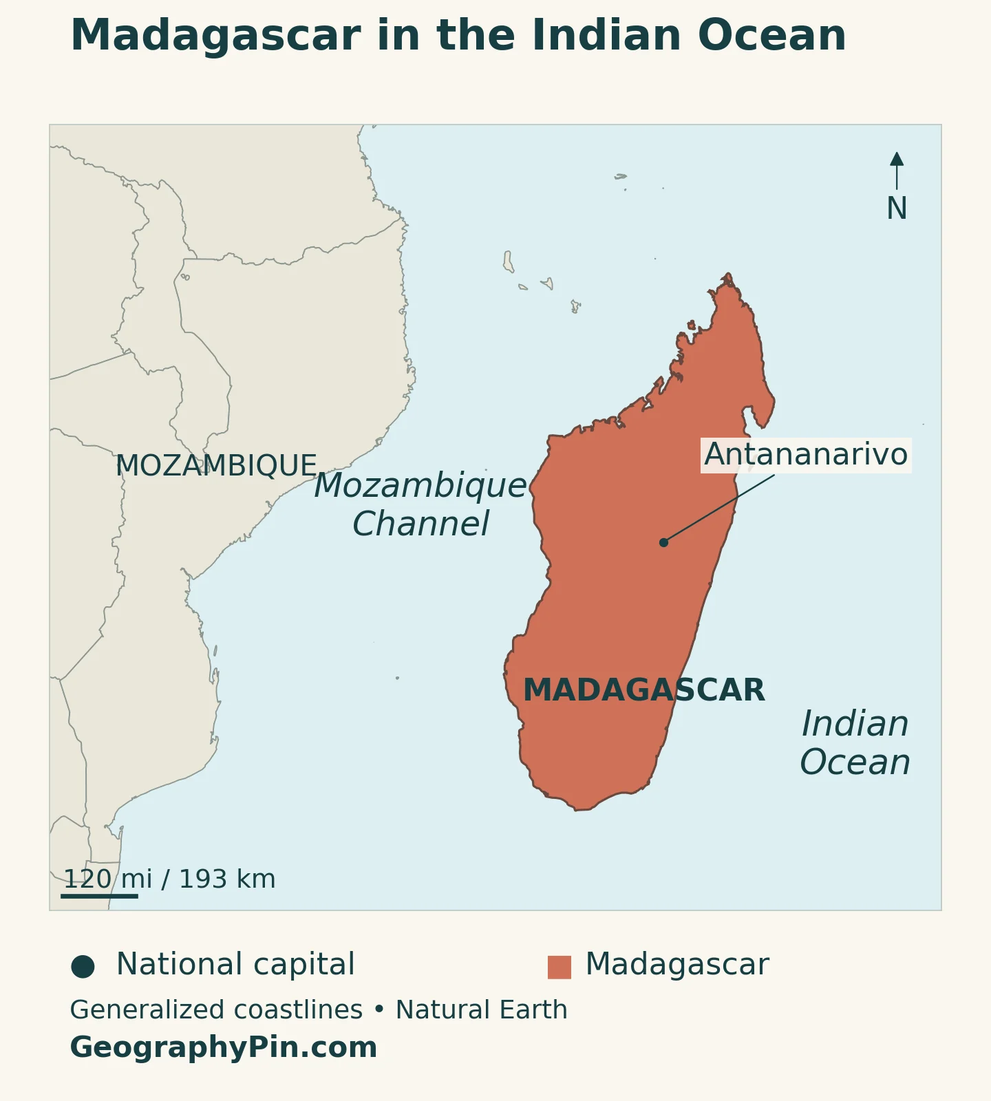
The name refers both to the large main island and to the sovereign country, which also includes smaller offshore islands. Antananarivo, the capital, is in the central highlands rather than on the coast. The Mozambique Channel is part of the Indian Ocean, not a separate ocean dividing Madagascar from Africa.
Our East Africa countries map places Madagascar among the island states included in the UN’s Eastern Africa grouping. That regional classification does not mean the country belongs to the East African Community, a separate organization.
For a first reading of the national map, locate Antananarivo, trace the highland belt and compare the narrow eastern side with the western side facing the channel. The island’s relief helps explain why those two coasts have different environments.
2. Country facts with dates and definitions
| Fact | Reference |
|---|---|
| Official name | Republic of Madagascar. |
| Capital | Antananarivo, in the central highlands. |
| Population projection | 32,658,977 at midyear 2026, INSTAT medium-variant national projection. |
| Census reference | 25,674,196 residents counted in May–June 2018, final RGPH-3 results. |
| Surface area | About 226,658 square miles (587,041 square kilometers), UNData reference year 2023; surface area rather than land area alone. |
| Official languages | Malagasy and French; Article 4, reaffirmed by the High Constitutional Court in August 2026. |
| Currency | Malagasy ariary (MGA). |
| Administrative regions | 24 regions under the 2023 legal framework. |
| Political context | Republic in a political and constitutional transition, as documented by the High Constitutional Court in November 2026. |
The population projection comes from INSTAT’s demographic report based on the 2018 census. Its medium variant models a midyear population; it is not a new census enumeration. The final census count remains a separate dated benchmark rather than a current population estimate.
Area figures also need a definition. The value above follows the UNData surface-area series, while other publications use different totals or describe only the main island. Keeping one stated measure avoids switching between country area, island area and land-only area within the same profile.
3. Central highlands and contrasting coastal landscapes
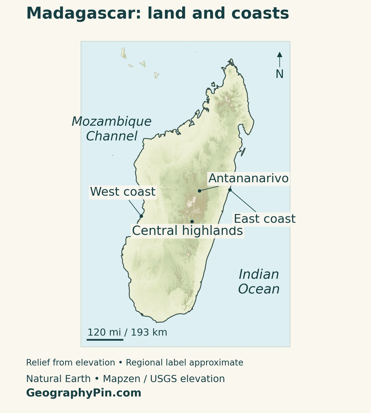
A belt of high ground runs through much of Madagascar’s interior. Its eastern side descends more abruptly toward the Indian Ocean, while the west includes broader plains and sedimentary basins. The south and southwest introduce much drier landscapes, so even the east–west comparison needs a north–south qualification.
| Setting | Location | Geographical character |
|---|---|---|
| Central highlands | Interior, including Antananarivo | Elevated terrain with cooler conditions than many low-lying coastal areas. |
| Eastern escarpment and coast | Facing the open Indian Ocean | Steeper slopes and a humid coastal setting exposed to moisture-bearing winds. |
| Western plains and basins | Facing the Mozambique Channel | Broader lowlands, seasonal rainfall and dry-forest environments in parts of the region. |
| South and southwest | Southern end of the island | Drier conditions, including spiny forest-thicket and areas vulnerable to drought. |
| North and northwest | Northern island and channel-facing coast | Seasonal monsoon influence adds variety to a simple wet-east, dry-west picture. |
The highlands connect the weather, rivers and cities
Antananarivo’s inland position is important to the country’s human geography. It places the capital in a highland environment, separated from maritime gateways by changes in elevation and terrain. A straight-line distance on a map does not describe the full challenge of connecting an inland city to the coast.
The highlands also influence drainage. Water falling inland moves toward different coasts, while steepness affects how quickly runoff descends. These links make relief more than a scenic background: it helps organize settlement, transport, rainfall and river systems.
The physical map uses broad regional labels rather than sharp climate boundaries. Conditions change through transition zones, and neither a highland label nor a coastal label implies that every place within it has identical vegetation or rainfall.
4. Why the east and west have different environments
Moist winds meet the eastern slopes first
Moisture-bearing easterly and southeasterly winds reach Madagascar from the Indian Ocean. As air rises against the eastern slopes, it cools and can produce cloud and rain. The eastern side is therefore generally more humid, while locations farther west are less directly exposed to the same incoming moisture.
The central highlands are also cooler because of their elevation. Farther west, rainfall is more strongly seasonal, and the southwest is particularly dry. This is a broad regional explanation, not a claim that western Madagascar receives no rain or that every eastern district stays wet every day.
Seasonal circulation matters alongside relief. During the southern summer, northwesterly monsoon flow brings moisture to northern and northwestern areas. The northwestern coast therefore should not be treated as climatically identical to the dry southwest simply because both face the Mozambique Channel.
Rainfall seasons do not remove the risk of extremes
A warmer, wetter season broadly runs from November to April, followed by a cooler, drier period in much of the country. The east can receive rain outside that general wet-season window. Local rainfall also varies considerably from one year to the next.
Tropical cyclones can bring destructive wind and heavy rain, while drought is a major concern in the south and southwest. Flooding and water shortage can therefore be serious problems in different parts of the same country. A wet national season does not ensure adequate rain for every farming district.
Research using satellite observations from 2004–2021 found that combined hot and dry conditions affected vegetation more strongly than isolated extremes, particularly in southern Madagascar. This helps explain why rainfall totals alone cannot fully describe agricultural stress: heat and the timing of moisture matter too.
5. Rivers, forests and biodiversity beyond the rainforest image
Madagascar’s rivers link the interior with both coasts. Many east-flowing rivers descend relatively short, steep routes toward the Indian Ocean. Western drainage systems include larger basins and lower-course floodplains. Lakes, lagoons and wetlands add environments that a simple outline map cannot show.
The Betsiboka shows the connection between highlands and coast
The Betsiboka carries sediment from the central highlands toward Bombetoka Bay on the northwestern coast and then into the Mozambique Channel. NASA astronaut photography shows its braided channels and sediment-built islands. Iron-rich soil contributes to the reddish or orange appearance that becomes especially visible after heavy rain.
This is a visible example of a wider process: river catchments connect events inland with conditions at the coast. Sediment transport, estuarine channels and mangroves belong to one interacting landscape, not three unrelated features. A colorful satellite image records conditions at a particular time, not a fixed river color or an unchanging coastline.
Madagascar has dry forests as well as rainforests
The Rainforests of the Atsinanana World Heritage property protects forest components along the eastern side of the island. These forests support many endemic and threatened species. “Endemic” means naturally restricted to a particular geographical area; it does not mean simply rare, colorful or endangered.
Madagascar’s long isolation is central to the evolution of its distinctive plants and animals, including lemurs. However, an endemism percentage for one protected property or group of species should not be presented as a percentage for all life in the country. Habitat and taxonomic scope matter.
Western Madagascar offers a different picture. The Andrefana Dry Forests World Heritage property includes dry forests and southwestern spiny forest-thicket, as well as limestone landscapes, lakes and mangroves. Its components demonstrate that exceptional biodiversity is not confined to humid rainforest.
The sharp limestone formations known as tsingy are also not forests of trees: they are rock landforms, although vegetation and wildlife occur around them. Comparing eastern rainforest with western dry-forest and limestone environments is more informative than describing the whole island as a uniform tropical jungle.
6. Antananarivo, coastal connections and regional administration
Antananarivo is Madagascar’s national capital and a major inland center. Toamasina, on the east coast, is a principal maritime gateway. JICA identifies the capital–Toamasina axis, connected by National Highway 2, as an important focus for transport and economic development.
The distinction is straightforward: the capital’s role and the port’s role are different, even though their connections are vital to the same national economy. Goods moving between the coast and the highlands depend on infrastructure crossing varied terrain. A country profile therefore needs both city locations, not only the name of the capital.
For a continent-wide reference, our list of African countries and capitals identifies Antananarivo alongside other national capitals.
Madagascar’s population is not concentrated entirely in cities. The final 2018 census classified 80.7% of residents as rural. That is a dated census finding, not a claim about the exact rural share today. It helps explain why farming communities and regional connections belong in a country profile alongside the capital.
The administrative map is another layer. Law 2023-012 established Ambatosoa and lists a national total of 24 regions. These legal divisions should not be confused with the broad physical regions shown on the relief map. Malagasy and French are the official languages, a status reaffirmed by the High Constitutional Court in 2026.
7. Economy and the current institutional setting
Agriculture is central to livelihoods, while Madagascar also exports products such as vanilla, nickel and apparel. The World Bank identifies weak infrastructure, limited access to services and recurring climate shocks among the constraints on development. Natural resources alone do not remove those constraints.
Geography connects these economic activities. Farms need reliable access to water and markets; ports connect producers and importers with overseas trade; and transport routes link the interior with coastal gateways. Tourism adds another use of distinctive landscapes and biodiversity, but the country is also a lived-in agricultural, urban and industrial economy.
Government descriptions require a current date. As of November 2026, Madagascar was in a political and constitutional transition following the changes of 2025. The High Constitutional Court’s November 4 opinion addressed conditions for a possible constitutional referendum. A proposed constitutional process should not be described as a completed change or an election already held.
Frequently Asked Questions
Why is eastern Madagascar generally wetter than the west?
Moist winds from the Indian Ocean meet the eastern slopes first. Rising air produces cloud and rain, while areas farther west are less directly exposed to that moisture. Seasonal monsoon flow also brings rain to the north and northwest.
What are Madagascar’s main physical regions?
A useful broad division includes the central highlands, eastern escarpment and coast, western plains and basins, and the drier south and southwest. Northern and northwestern environments add further variety.
Is all of Madagascar covered by rainforest?
No. Rainforests are especially associated with the humid east, but the country also has dry forests, spiny thickets, grassland, farmland, wetlands and urban areas.
What Did We Learn Today?
Madagascar’s central highlands help organize its rainfall, rivers and settlement. The humid east, more seasonal west and dry southwest support different environments, while Antananarivo and coastal gateways connect the interior with the ocean. Its distinctive biodiversity belongs to several habitat types, not only rainforest.
Sources & Data Notes
Population follows INSTAT’s final 2018 census and its medium-variant midyear 2026 projection, not an interchangeable UN estimate. Surface area follows UNData’s 2023 reference. Administrative count follows the 2023 law; language and transition notes use the cited 2026 court decisions. The older FAO reference is used only for broad drainage geography, not current statistics. Habitat descriptions do not imply continuous forest cover or precise ecological boundaries.
- INSTAT: RGPH-3 demographic projections, July 2023, Table 3.1 medium variant
- INSTAT: final 2018 census results and rural population share
- UNData: surface area, capital and currency
- Madagascar Law 2023-012: Ambatosoa and 24-region administrative total
- High Constitutional Court: August 21, 2026 decision reaffirming Malagasy and French
- High Constitutional Court: November 4, 2026 opinion on the constitutional transition
- Republic of Madagascar: first Biennial Transparency Report, March 2026, physical and climate context
- Gouveia, Silva and Russo: climate extremes, vegetation and regional climate contrasts
- FAO: historical reference on inland drainage, floodplains and coastal wetlands
- NASA Earth Observatory: Betsiboka sediment transport and Bombetoka Bay
- UNESCO: Rainforests of the Atsinanana and endemic biodiversity
- UNESCO: Andrefana Dry Forests and western habitat diversity
- JICA: Antananarivo–Toamasina economic axis and infrastructure
- World Bank: economic sectors and development constraints
Map method: Original GeographyPin maps use public-domain Natural Earth country geometry and Antananarivo’s populated-place location. Coast pointers follow the source shoreline. Shaded relief uses Mapzen Terrain Tiles with USGS SRTM and GMTED2010 elevation data. Terrain colors show elevation, not vegetation or rainfall. The central-highlands label is a broad reference, not a measured regional perimeter. Web Mercator scale varies with latitude; small islands and coastlines are generalized, and maritime claims are not resolved. The cover is an original flag-and-outline design.
