
Kosovo’s landscape is easier to understand as a combination of interior basins and surrounding mountains than as a single mountain block. Pristina lies in the eastern part of this setting, while Dukagjin forms the broad western lowland. Its political description also needs care: Kosovo has its own institutions, but its declaration of independence is not universally recognized and Serbia continues to claim the territory.
Kosovo is a landlocked territory in the central Balkans with Pristina as its capital and its own governing institutions. It declared independence in 2008; recognition is not universal and Serbia does not recognize it. Its geography combines the Kosovo Plain, the western Dukagjin basin, hills and surrounding ranges, including the Sharr Mountains in the south.
How to use this article: Clarify the political status, compare the main landscapes, or examine population coverage.
1. Locate Kosovo and understand its status
Kosovo lies inland in southeastern Europe. Serbia is to the north and east, North Macedonia to the southeast, Albania to the southwest and Montenegro to the west and northwest. It has no seacoast, even though some of its water systems connect with coastal drainage farther downstream.
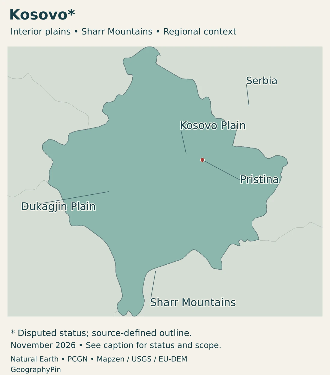
The Kosovo Plain and Dukagjin are geographic settings, not separate sovereign territories. Mountain ranges continue across political boundaries, and a national-park designation covers only a defined part of a wider landscape.
Our Europe map supplies wider context, while the European countries and capitals guide explains the broader reference list.
Declaration, recognition and effective government are different
Kosovo declared independence in 2008 and maintains its own constitutional institutions. Many governments recognize it, but recognition is not universal. Serbia continues to claim the territory and does not recognize Kosovo’s independence. Separate effective institutions therefore coexist with an unresolved international-status dispute.
A map can show Kosovo separately without resolving the sovereignty dispute. Likewise, membership in an international organization and recognition by individual governments are different questions. Undated recognition totals can obscure changes in official positions and disagreements about how those positions are counted.
2. Country facts and population coverage
| Fact | Value | Meaning or coverage |
|---|---|---|
| Capital | Pristina | Also written Prishtina; seat of Kosovo’s central institutions. |
| Population | 1,582,322 | Agency estimate at December 31, 2025, not a new census count. |
| Published area | About 4,210 square miles (10,905 km²) | KAS July 2025 census volume; cadastral reference April 2017. |
| Official languages | Albanian and Serbian | Other languages have municipal or other official use under law. |
| Currency | Euro (EUR) | De facto use without EU or euro-area membership. |
| Government | Parliamentary institutions | Kosovo’s own constitutional framework; international recognition remains disputed. |
| Local administration | Municipalities | Basic units of local self-government under the Constitution. |
Resident estimates are not the same as a raw census count
The latest annual estimate used here is 1,582,322 residents at December 31, 2025. It is distinct from the 2024 census-based population total. The census publication includes estimated residents for four northern municipalities, so that total is not simply a count of individually enumerated people everywhere.
The census reference date was April 5, 2024. The later year-end estimate updates the population through demographic components, including births, deaths and migration. A change between those dates should not be described as a change between two identical census operations.
Population data describe a specified reference date and residence concept. They should not automatically include everyone of Kosovar origin living abroad. Nor should a municipality’s total be treated as the population of its continuously built-up urban center.
The table separates the date of the population estimate from the publication date. Statistical territorial coverage is described on its own terms rather than used as proof of international recognition.
3. Two main basins and surrounding mountains
Compare the basins and their mountain margins
| Setting | Landscape | Useful distinction |
|---|---|---|
| Kosovo Plain | Interior basin and lower terrain in the eastern part of Kosovo. | A plain within a mountainous region is not necessarily close to sea level. |
| Dukagjin basin | Broad western lowland with river corridors and surrounding uplands. | It is a physical region, not a separate political administration. |
| Western mountain margins | Highland terrain adjoining the western basin. | Valley access and steep slopes create very different local settings. |
| Sharr Mountains | Southern mountain range continuing toward North Macedonia. | The range and individual national-park boundaries are not interchangeable. |
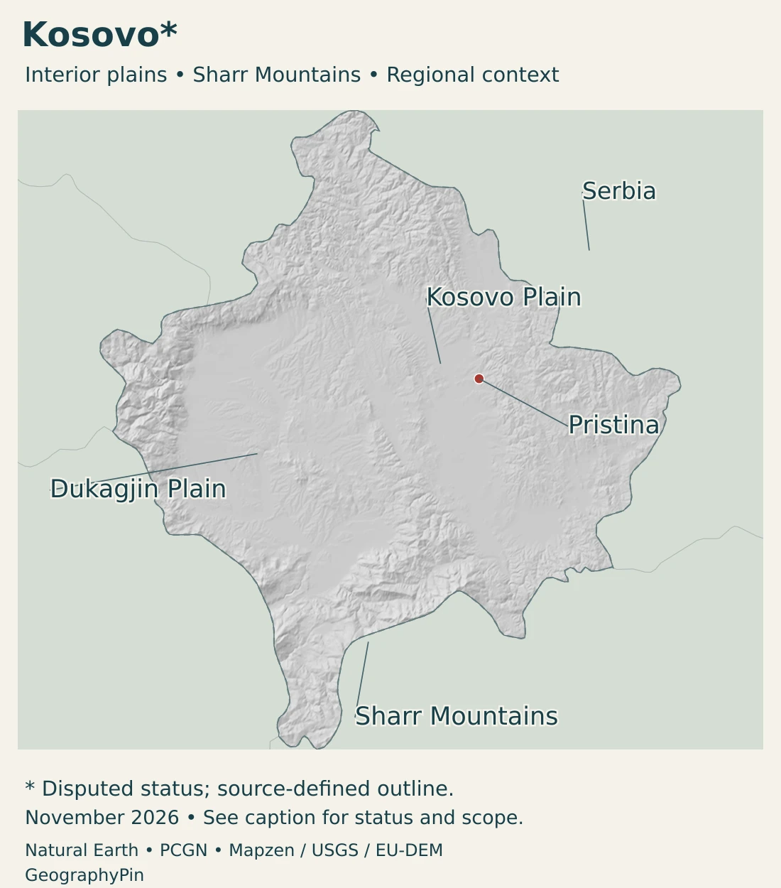
The Sharr range extends beyond one jurisdiction
The Sharr Mountains form a major part of the southern mountain setting. Kosovo’s environmental agency places its Sharr national park along the North Macedonia boundary, with management based in Prizren. The mountain landscape continues beyond that park’s jurisdiction.
This distinction matters when comparing maps: a mountain range is defined by landforms, while a protected area has a legal boundary and a management institution. A label for Sharr does not imply that every slope in the range belongs to the same national park.
Basins, intervening hills and mountain margins also differ in how people move through them. A short straight-line distance across a ridge need not correspond to a short road journey. The lower corridors and passes are therefore as important to orientation as the highest terrain.
4. River systems, water supply and climate
Several river systems organize the landscape
The environmental agency organizes its water reporting around the Drini i Bardhë, Ibër, Morava e Binçës and Lepenc systems. These catchments explain the direction of runoff and the relationship between uplands, valley settlements and water supplies.
A river basin includes the land draining toward a river, not only its channel. Surface streams and groundwater both matter, and the distribution of water resources is uneven. The agency’s water report identifies the Dukagjin region as comparatively well supplied, without implying that every community there has identical access or water quality.
Reservoirs are working infrastructure
Ujmani, also known as Gazivoda, is a reservoir created by a dam on the Ibër system. The environmental agency describes its uses for drinking water, irrigation, industry and power generation. It is therefore more than a scenic lake or an isolated blue shape on a map.
Reservoir levels and water quality change over time. A generalized outline is useful for geographic orientation but cannot show the current storage volume, an operational release schedule or the safety of a particular water supply.
Continental conditions with local contrasts
The interior has a predominantly continental setting, while the western Dukagjin basin receives a stronger Adriatic climatic influence. Elevation and surrounding ranges further modify local conditions. Basin-floor weather should not be applied directly to high mountain slopes.
These contrasts do not remove the need to distinguish climate from weather. Rainfall and temperatures in an individual season can differ substantially from the long-term pattern. Agriculture and water management depend on both long-term patterns and the conditions of individual years.
5. Pristina, settlement and languages
Pristina is the institutional center
Pristina is the capital and the principal location of Kosovo’s central institutions. The city, its municipality and the wider area around it are different geographic units. An administrative population total may include settlements beyond the dense urban core.
Prizren provides a contrasting southern reference point near the Sharr setting. The environmental agency’s park administration is based there, illustrating the connection between a city and a wider mountain landscape without making the city itself part of every protected mountain zone.
Official languages and local use
Albanian and Serbian are official languages under Kosovo’s Constitution. Turkish, Bosnian and Roma languages have municipal-level or other official use as provided by law. These provisions are more precise than describing every listed language as equally official throughout the territory.
Place names may appear in Albanian, Serbian or other established forms. Pristina/Prishtina and Ujmani/Gazivoda are examples of names readers may encounter in different sources. Variant names are not evidence of different physical places.
Language, ethnicity, citizenship and residence are separate categories. A territorial population figure does not describe the identity of every individual, and a majority language does not erase the rights or presence of other communities.
6. Institutions and the geography of the economy
Kosovo’s Constitution establishes a parliamentary system, with an Assembly, a Government and a President. Municipalities are the basic units of local self-government. These institutions describe how Kosovo is organized internally; their existence does not mean that all other governments recognize its statehood.
Kosovo uses the euro de facto without a monetary agreement with the European Union. It is not an EU or euro-area member. The currency used for transactions is therefore a separate question from participation in the institutions that govern that currency.
Lignite connects geology with the energy system
Lignite-based electricity generation is a major feature of Kosovo’s energy system. The World Bank’s climate assessment describes the challenge of moving from aging fossil-fuel infrastructure toward a more diversified, lower-emission system.
The existence of a mineral resource does not guarantee reliable or inexpensive energy at every moment. Generating equipment, maintenance, networks, imports and seasonal demand all influence supply. Proposed energy-transition pathways are scenarios and policy choices, not evidence that the existing plants have already closed.
Rural livelihoods and land use
Agriculture remains important for rural livelihoods. The European Environment Agency’s Kosovo profile highlights land fragmentation, food-system infrastructure and pollution from agricultural runoff among the sector’s challenges.
These issues connect land use with water management. Fertilizers and other materials can move from fields into streams, while irrigation depends on water availability and infrastructure. A basin’s productive land and its water-quality pressures are parts of the same landscape.
A small territory with cross-border connections
Mountains, river systems and electricity networks do not end neatly at political boundaries. Kosovo’s economic and environmental connections extend into the wider Balkans even while its international status remains disputed.
The clearest geographic overview therefore holds two ideas together: functioning institutions and everyday economic activity within Kosovo, and a political status that is not universally accepted. Neither the landscape nor the legal disagreement should be allowed to erase the other from the description.
Frequently Asked Questions
Is Kosovo universally recognized as an independent country?
No. Kosovo declared independence in 2008 and has its own institutions, but international recognition is not universal. Serbia does not recognize it and continues to claim the territory.
Is Kosovo entirely mountainous?
No. The Kosovo Plain and Dukagjin basin form substantial lower-lying interior landscapes, surrounded and separated by hills and mountains.
Is Ujmani the same reservoir as Gazivoda?
Yes. These are alternative names for the reservoir on the Ibër system. The names do not identify two separate lakes.
What Did We Learn Today?
Kosovo combines interior basins with surrounding mountain ranges, rather than forming one uniform highland. Its rivers and reservoirs support settlements, farming and energy. Pristina is the capital of its own governing institutions, while international recognition remains disputed and population figures require clearly stated dates and coverage.
Sources & Data Notes
Population is a year-end resident estimate for 2025. The 2024 census-based total incorporated estimates for four northern municipalities; it should not be described as complete direct enumeration. Area is the KAS-published cadastral figure, not a newly measured 2026 area or a separately defined dry-land measure. Conversions are rounded. Statistical coverage, effective institutions and diplomatic recognition are separate concepts.
- Kosovo Agency of Statistics, annual population estimates: December 31, 2025 estimate 1,582,322; table updated August 31, 2026.
- Kosovo Agency of Statistics, demographic census results, July 2025: 2024 census-based population includes estimates for four northern municipalities. Area 10,905 km² follows cadastral agency data from April 2017, not a new 2024 land survey.
- Constitutional Court, Constitution of Kosovo: Articles 4, 5, 12 and 13: parliamentary institutions, language provisions, municipalities and capital. This describes Kosovo’s institutional framework rather than universal recognition.
- European Commission, the euro outside the euro area: Kosovo uses the euro de facto without a monetary agreement; this is not EU or euro-area membership.
- UK Parliament, Kosovo: developments since 1999: Declaration in 2008, separate institutions and recognition qualifications. No recognition count is treated as current.
- Serbian Ministry of Foreign Affairs, February 17, 2026 statement: Serbia’s continuing non-recognition position; other allegations in the statement are not adopted.
- European Commission, Kosovo: Separate institutional engagement with status-qualified terminology.
- Kosovo Environmental Protection Agency, State of Water 2010: Relief section, page 16: Kosovo Plain and Dukagjin Plain within the surrounding mountain landscape. Historical statistical figures are not used as current data.
- Kosovo Environmental Protection Agency, State of Water 2020: Basin names, groundwater and surface-water setting, Ujmani/Gazivoda reservoir functions and broad climatic contrasts. Historical water-quality measurements and levels are not presented as current.
- Kosovo Environmental Protection Agency, Sharr National Park Directorate: Southern mountain setting, adjoining North Macedonia and management based in Prizren. Older park-area figures and administrative wording are not used as current statistics.
- World Bank, Kosovo Climate and Development Report: Lignite-based energy system and transition scenarios; modelled future pathways are not completed changes.
- European Environment Agency, Kosovo environmental profile 2025: Agriculture, fragmented land use, diffuse pollution and environmental infrastructure. No undated economic shares are reproduced.
Map sources and scope: Original GeographyPin maps use public-domain Natural Earth boundaries, city coordinates and lake geometry. The complete separate Kosovo territorial record is retained. Its dashed outline indicates disputed status, not a frontline or newly surveyed boundary. Separate depiction does not imply universal recognition or endorse a sovereignty claim. November 2026 dates this presentation, not a new border survey.
Pristina uses Natural Earth city-coordinate attributes. The Sharr Mountains locator follows the PCGN Kosovo Toponymic Factfile, December 2025. The Kosovo and Dukagjin plain labels mark broad lower-lying landscapes, not surveyed regional boundaries. No administrative or physiographic polygons are invented, and Sharr is a range locator rather than a summit or national-park boundary.
Source lake geometry is generalized and does not represent current water levels. No fictional reservoir shapes or river courses are added; the maps are not exhaustive water-network inventories.
Hillshade is calculated from genuine elevations accessed through Mapzen Terrain Tiles, with no vertical exaggeration. Global elevation data courtesy of the U.S. Geological Survey. Produced using Copernicus data and information funded by the European Union – EU-DEM layers. Elevation-source attribution and terms apply. Shading is not bathymetry or numerical elevation bands.
The cover uses Kosovo flag artwork from Commons. The intact flag retains its 7:5 proportions and all six stars, and appears separately from the decorative outline motif.

