Cyprus has a physical landscape that is easier to understand than its political map. Two mountain systems frame a central plain, while coastal settlements face the eastern Mediterranean. The island, the internationally recognized Republic of Cyprus and the areas under different forms of control are related, but they are not interchangeable.
Cyprus is an island in the eastern Mediterranean. The Republic of Cyprus is the internationally recognized state and an EU member, with Nicosia as its capital. The island remains divided in practice, with a UN buffer zone separating areas of effective control and separate British Sovereign Base Areas. Troodos, Mesaoria and the northern Kyrenia/Pentadaktylos range explain its main physical contrasts.
How to use this article: Clarify island and state, compare the major landscapes, or explore freshwater supply.
1. Locate Cyprus and understand its status
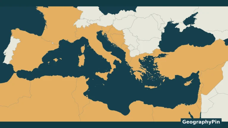
Cyprus lies south of Türkiye, west of the Levantine coast and north of Egypt. Its eastern Mediterranean location helps explain why regional classifications differ: it is geographically associated with Western Asia while also having strong European political and institutional connections.
Regional labels answer different questions. A geographic grouping is not a ruling on cultural identity or EU membership. Our guides to Middle East country definitions and Asian countries and capitals explain the wider classification context.
Recognition is not the same as effective control
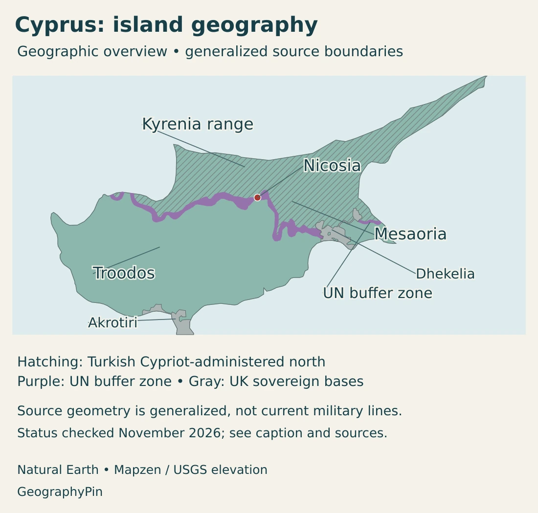
The Republic of Cyprus is the internationally recognized state. Its government does not exercise effective control over the northern part of its territory, where a Turkish Cypriot administration operates. The self-declared “Turkish Republic of Northern Cyprus” is recognized only by Türkiye. UN Security Council Resolution 541 rejected the declaration’s legal validity and called on states not to recognize any Cypriot state other than the Republic.
The separate British Sovereign Base Areas of Akrotiri and Dhekelia remain under UK sovereignty under the 1960 treaty arrangements. They are not leased territory under the Republic’s sovereignty. This is why the physical island’s perimeter is not identical to the Republic’s sovereign territory.
The UN buffer zone is not an ordinary international boundary between two equally recognized countries. It is part of the island’s ceasefire and peacekeeping setting. Likewise, the British bases have a separate legal status: they are not simply another administrative district of the Republic.
A useful map must therefore separate physical land, legal status and actual administration. A color can identify an area of control without recognizing a new sovereign state, and a physical-region label does not decide a political claim.
2. Country facts with territorial coverage
| Measure | Value | Scope or definition |
|---|---|---|
| Capital | Nicosia | Capital of the Republic of Cyprus; the city has a divided setting. |
| Population | About 996,600 | End-2025 provisional CYSTAT estimate for the government-controlled areas, not the whole island. |
| Island area | 9,251 km² (about 3,572 sq mi) | Physical island figure published by the Cyprus High Commission; includes areas outside the Republic’s effective control and the separate British bases. |
| Official languages | Greek and Turkish | Official languages of the Republic; Greek is also an official EU language. |
| Currency | Euro (EUR) | Currency of the Republic; not a claim that every administration on the island uses the same currency. |
| Government | Presidential republic | President is head of state and government. |
| EU membership | Since 1 May 2004 | EU law is suspended in the areas where the Republic’s government does not exercise effective control. |
Territorial coverage is essential when reading Cyprus statistics. A population figure for the government-controlled areas cannot be described as a count of everyone living on the island. Nor should it be divided by a whole-island area to produce an apparently precise population density.
Nicosia is the capital, but a number for Nicosia district, the municipality or the wider urban area can refer to different populations. The city’s divided setting adds another reason to check the geographic definition before comparing urban statistics.
3. Troodos, Mesaoria and the northern range
Mountains and a plain do not follow the political lines
| Setting | Physical character | Geographic significance |
|---|---|---|
| Troodos | A broad mountain mass in the central and southwestern island, with rocks of oceanic-crust origin. | Creates cooler uplands and influences rainfall, drainage and forest environments. |
| Mesaoria | The central plain between the major mountain systems. | Contains Nicosia’s wider setting and important lowland agricultural landscapes. |
| Kyrenia/Pentadaktylos range | A narrow, steep-sided northern mountain chain, with prominent limestone rocks. | Separates the northern coastal strip from the central plain and affects local water movement. |
| Coastal lowlands | Varied plains and terraces around the island’s margins. | Support coastal settlements, transport connections and tourism, with environments distinct from the mountains. |
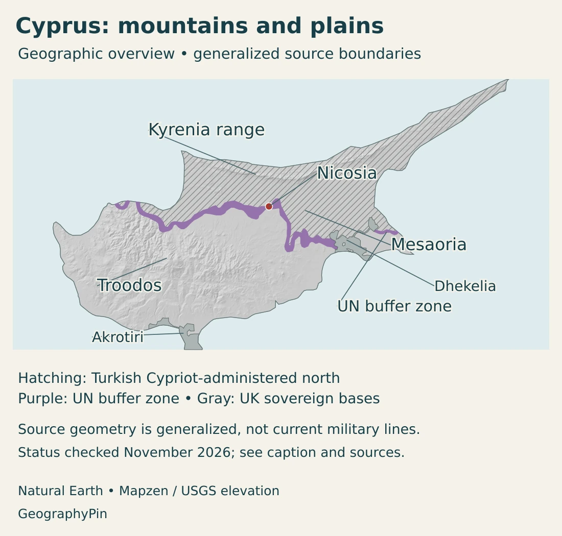
Troodos is not simply a ridge of ordinary sedimentary rock. It is an ophiolite: a fragment of oceanic crust and upper mantle exposed on land through tectonic processes. This makes the mountain area important for understanding how ocean-floor rocks form and how they can later become part of an island landscape.
The Troodos UNESCO Global Geopark highlights these rocks alongside the region’s forest and cultural landscapes. The geopark boundary is not the boundary of the entire mountain range. A protected or designated area and a physical mountain system describe different extents.
Mesaoria lies between Troodos and the northern range. Its lower terrain contrasts with the uplands, but “plain” does not mean an absolutely level surface. Sediments, river valleys and local relief create differences within the central lowland setting.
The Kyrenia range, also called Pentadaktylos, runs along the north of the island. Limestone and other sedimentary formations produce a different geological character from Troodos. Fractures and soluble rock can create underground drainage and springs, linking the structure of the mountains with water availability.
Coastal areas are not all identical, either. Bays, terraces and lower plains create different settings around the island. The physical landscape continues across administrative and ceasefire lines; those lines should not be mistaken for the edges of mountain ranges or watersheds.
4. Mediterranean climate and scarce freshwater
Cyprus has a Mediterranean climate, with long, hot and generally dry summers and cooler, wetter winters. Elevation modifies that pattern: the higher Troodos areas are cooler than the central plain and can receive winter snow. Coastal conditions are moderated by the nearby sea.
Most water replenishment occurs during the wetter part of the year, while summer creates sustained demand for stored water. A sunny coast and a snowy mountain can therefore belong to the same island climate without contradiction.
Reservoirs, groundwater and desalination
Freshwater supply depends on more than the amount of rain in a single storm. Water must be stored, move into aquifers or remain available in streams and reservoirs. The Water Development Department identifies uneven rainfall, recurring drought and pressure on groundwater and surface-water resources as central management issues.
In the Republic’s water-management system, seawater desalination supplements drinking-water supply, while treated wastewater is reused for irrigation and other specified purposes. These are different processes: desalination removes salt from seawater, while reuse treats water that has already been used.
Reservoirs help carry water from wetter periods into drier ones, but their mapped outlines are not measurements of how much water they contain today. Groundwater also requires careful management because extraction, recharge and saltwater intrusion can change the condition of an aquifer.
Mountain rocks influence these systems. Fractures in Troodos can allow water to enter and move through the ground, while limestone in the northern range supports a different type of underground drainage. Rainfall, geology and human infrastructure jointly shape water supply.
Water-management data published for the government-controlled areas should not automatically be generalized to every part of the island. Infrastructure networks and statistical coverage are part of the geographic context, just as much as climate and terrain.
5. Nicosia, coastal cities and languages
Nicosia occupies an inland position in the central plain rather than a coastal port setting. Limassol, Larnaca and Paphos illustrate the importance of the southern and western coasts for settlement and connections beyond the island. Their environments differ from the higher Troodos villages and from the narrow northern coastal strip.
The Republic’s administrative geography and the areas of effective control are different layers. A district name can describe territory extending beyond the government-controlled area, so district-level statistics need their own coverage notes. The British bases and UN buffer zone should not be counted as ordinary Republic districts.
Constitutional languages and community geography
Greek and Turkish are the Republic’s official languages. This is distinct from the EU’s institutional language list, in which Greek is an official language. The constitutional language framework should not be confused with a claim that both languages are used equally in every locality or public service.
The distinction between a community, a language and a political administration matters. A language does not itself define a sovereign boundary, and people’s identities cannot be reduced to the color used for an area on a reference map.
The divided setting affects movement and daily connections within the island. The overview here is not a list of currently open crossing points or a travel-permission guide; those operational details require separate, current checks.
6. Government, Europe and economic geography
The Republic of Cyprus is a presidential republic, with the president serving as both head of state and head of government. It joined the European Union in 2004 and adopted the euro in 2008. EU membership is a legal and institutional relationship, not a change in the island’s physical location.
EU law is suspended in the areas where the Republic’s government does not exercise effective control. The European Commission explicitly distinguishes the Green Line from an external EU border. The British Sovereign Base Areas have their own treaty and legal arrangements, rather than being ordinary parts of the Republic.
Relief and climate help explain some of the island’s economic geography. Coastal settlements and visitor destinations depend on transport connections and water supply. Mountain villages, forests and heritage sites provide a different setting from the lowland urban centers.
Troodos also has a long relationship with mineral resources, especially copper. Its geological structure helps explain that historical association. The existence of mineral-bearing rocks should not be confused with a claim that every former mining area is operating today.
The geopark’s account of local communities highlights village heritage and wine production in the Troodos region. These are concrete examples of landscape and cultural activity working together, rather than evidence that the whole island has one uniform tourist economy.
Water is a connection between these activities. Urban residents, farming and visitor facilities all depend on reliable supply, while dry summers place pressure on resources. Infrastructure can reduce dependence on rainfall, but it does not erase the environmental differences between coast, plain and mountain.
Understanding Cyprus therefore requires two maps at once: the physical island and its political-administrative setting. Neither should replace the other. Troodos and Mesaoria explain relief and climate; recognition, effective control, the buffer zone and British bases explain why national statistics and public services need explicit territorial definitions.
Frequently Asked Questions
Is Cyprus one island or two countries?
Cyprus is one island. The Republic of Cyprus is the internationally recognized state, but the island is divided in practice. The northern administration is not an equally internationally recognized second state; the UN buffer zone and British Sovereign Base Areas also require separate treatment.
Are Troodos and the Kyrenia range the same mountains?
No. Troodos is the broader central and southwestern mountain mass, with oceanic-crust rocks. The Kyrenia/Pentadaktylos range is a narrower northern chain with a different geological character. Mesaoria lies between them.
Does a Cyprus population figure always cover the whole island?
No. Many official Republic of Cyprus statistics cover only the government-controlled areas. Check the reference date and territorial coverage before comparing figures or calculating density.
What Did We Learn Today?
Cyprus combines two mountain systems, a central plain and varied coastal lowlands. Its Mediterranean climate makes freshwater storage and supply especially important. The island’s physical geography differs from its political map: the recognized Republic, areas of effective control, UN buffer zone and British bases must be distinguished. Dates and territorial coverage are therefore essential parts of every population or area figure.
Sources & Data Notes
Reviewed in November 2026. Population and area describe different geographic extents and must not be combined into a density calculation. Provisional estimates may be revised.
- CYSTAT population database, annual population table: End-2025 total 996.6 thousand, provisional; table updated 9 July 2026. The estimate concerns the government-controlled areas.
- CYSTAT, Demographic Statistics 2024: Coverage and census-based annual population-estimation methodology.
- Cyprus High Commission, general information: Published area of the physical island: 9,251 km². This is not a measurement of the government-controlled area.
- European Union, Cyprus country profile: Capital, official languages, presidential system, euro and EU membership. Statistical scope follows the separately identified CYSTAT source.
- UN Security Council Resolution 541 (1983): Recognition and sovereignty, particularly paragraphs 2, 6 and 7.
- European Court of Auditors, assistance to the Turkish Cypriot community: Recognition and buffer-zone background, paragraphs 3–4.
- UN Security Council Resolution 2815 (2026), mandate registry: Current peacekeeping mandate reference at the November 2026 review.
- European Commission, Green Line Regulation: EU-law suspension and the distinction between the Green Line and an external EU border.
- UK House of Commons Library, Sovereign Base Areas: UK sovereignty and the 1960 treaty arrangements.
- Cyprus Geological Survey Department, geology: Troodos ophiolite, Mesaoria, northern limestone range and groundwater settings.
- Cyprus Geological Survey Department, Troodos Geopark: Designated geopark extent, geology and village heritage.
- Troodos Geopark, wine routes and wineries: Village vineyards and wine-producing landscapes.
- Deputy Ministry of Tourism, climate and weather: Mediterranean seasonality and contrasts with higher Troodos elevations.
- Water Development Department, Significant Water Management Issues: May 2021 report: uneven rainfall, drought, water resources, desalination and treated-water reuse. Used for management context, not current reservoir volumes.
Map sources and political scope: Original GeographyPin maps use public-domain Natural Earth island, administrative-area and city-coordinate data. The island overview combines the source records for Cyprus, the northern administration, buffer zone and British bases. These data categories are not recognition of a separate northern sovereign state. Hatching and overlays distinguish generalized areas of administration and the buffer zone; they are not a current survey of military positions, access rights or exact ceasefire boundaries.
The source includes the Kokkina enclave. The purple stroke enhances visibility and does not show the buffer zone’s true width at every location. Nicosia follows the source coordinate attributes; mountain and plain labels mark broad locations rather than measured region boundaries or exact summits. November 2026 is the status-review date, not a new boundary-survey date.
Hillshade is derived from real elevations accessed through Mapzen Terrain Tiles. Global elevation data courtesy of the U.S. Geological Survey. Produced using Copernicus data and information funded by the European Union – EU-DEM layers. Elevation-source attribution and terms apply. Shading represents terrain form, not numerical elevation bands or a local navigation map.
The cover uses the Republic of Cyprus flag designed by İsmet Güney, with SVG artwork by Vzb83 and contributors, both as an outline motif and as an intact flag. The UK bases remain separately gray. The decorative motif does not imply effective Republic government control throughout the island.