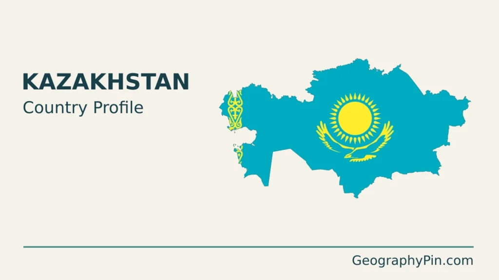
Kazakhstan’s broad outline stretches from the Caspian shore to the mountains near China. Understanding the country means looking beyond the image of an uninterrupted grassland: lowlands, uplands, deserts, mountain valleys and separate drainage basins all shape where water, farming and cities are found.
Kazakhstan is the world’s largest landlocked country by area, centered in Central Asia, with Astana as its capital. Its geography combines northern steppe, central uplands, western Caspian lowlands and eastern and southeastern mountains. It is landlocked despite bordering the Caspian Sea, because that inland water body has no natural outlet to the world ocean.
How to use this article: Compare the main landscapes, distinguish the river and lake systems, or explore Astana and Almaty’s different roles.
1. Locate Kazakhstan and read its map
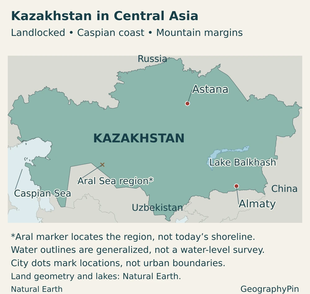
Kazakhstan borders Russia to the north and west, China to the east, and Kyrgyzstan, Uzbekistan and Turkmenistan to the south. Its western coast faces the Caspian Sea. That coast is important for ports and energy production, but it is not an ocean coastline.
Most of Kazakhstan lies in Asia. Under the commonly used Ural River convention for the Europe–Asia boundary, a smaller western part lies in Europe. This is a geographic convention across the connected Eurasian landmass, not an international border or a division into two different states. Kazakhstan is usually grouped with Central Asia in regional geography.
Why a Caspian coast does not mean ocean access
The Caspian Sea is an enclosed inland water body. Water flows into its basin, but it has no natural river outlet to an ocean. Ships can use Caspian ports and transport connections beyond them without changing Kazakhstan’s landlocked geographic status. A coast, a seaport and direct access to the world ocean are not interchangeable ideas.
2. Country facts with dates and definitions
| Item | Figure or description |
|---|---|
| Capital | Astana |
| Population | 20,633,529 people, Bureau of National Statistics estimate as of October 1, 2026 |
| Reported territory | About 1,052,090 square miles (2,724,900 km²), official national territorial figure |
| Language status | Kazakh is the state language. Russian is officially used alongside Kazakh in state organizations and local self-government bodies. |
| Currency | Kazakhstani tenge (KZT) |
| Political system | Unitary presidential republic |
| First-level administrative units | 17 regions and 3 cities of republican significance: Astana, Almaty and Shymkent |
| Time zone | UTC+5 nationwide, following the change introduced on March 1, 2024 |
The population is a dated estimate, not a count conducted on that day. The territorial figure is the government’s reported country area; it is not presented here as a separately measured dry-land-only total. A lake’s changing shoreline should not be confused with a corresponding change in the country’s international boundaries.
3. Steppe, lowlands and mountain margins
The main landscape contrasts
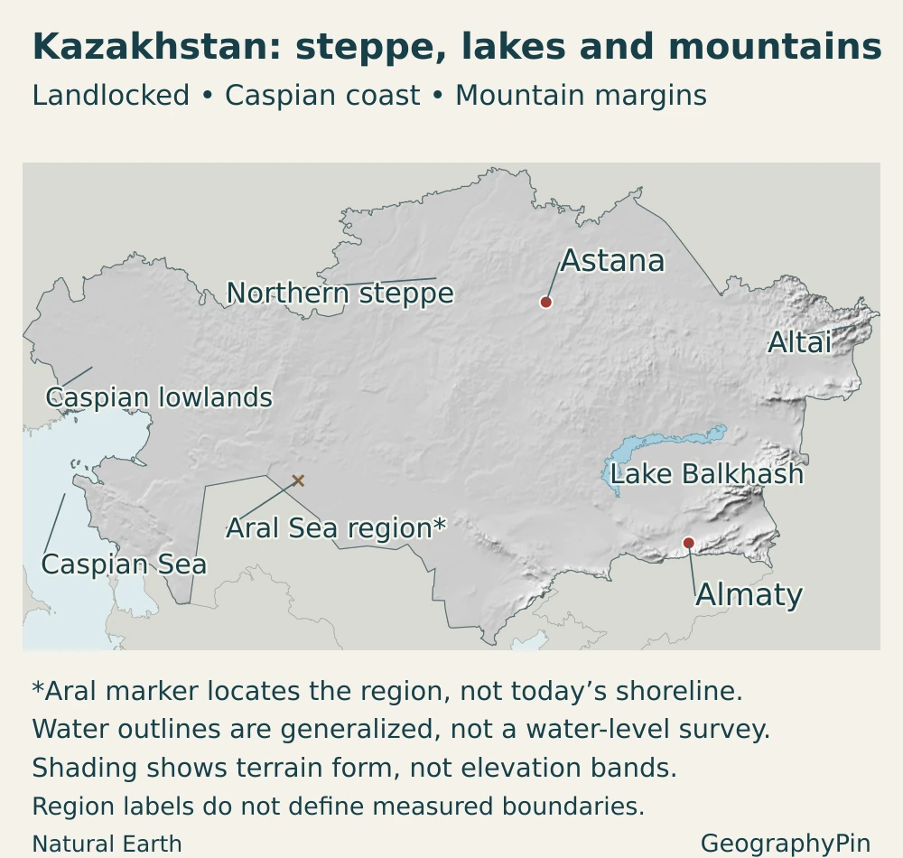
Northern Kazakhstan forms part of the broad Eurasian grassland belt. Farther south, drier conditions favor semi-desert and desert landscapes. The change is a broad environmental gradient, not a sharp line following an administrative boundary. Nor does “steppe” mean that every part of the country is flat: the central uplands and the mountain margins interrupt the plains.
| Landscape | Where to look | Geographic significance |
|---|---|---|
| Northern plains and steppe | Near the Russian border, including the grain-growing north | Open grassland and cultivated plains; a major setting for rain-fed spring wheat |
| Central uplands | Saryarka, or the Kazakh Uplands, in the interior | Hills, low mountain massifs and intervening basins rather than one level plain |
| Caspian lowlands | Western Kazakhstan around the northern and northeastern Caspian shore | Low-lying terrain, inland coastal environments and major oil-producing areas |
| Southern drylands | Across the interior toward the Aral and Balkhash basins | Semi-desert and desert landscapes where river water and irrigation are especially important |
| Eastern and southeastern mountains | Altai in the east; Tian Shan and associated ranges in the southeast | Strong elevation contrasts, snow storage and mountain-fed rivers supplying lower basins |
The Altai and Tian Shan are not alternative names for a single range. They occupy different parts of the mountain margin. Almaty sits near the northern Tian Shan, whereas the Altai belongs farther northeast. Central uplands, meanwhile, are part of the interior relief rather than the high mountain wall along the southeastern edge.
Landscape also helps explain why distances on the map can be deceptive. Crossing open steppe is a different geographic problem from crossing a mountain divide, and settlements separated by dry country may depend on the same river arriving from a wetter, higher catchment.
4. Climate, rivers and changing inland waters
Kazakhstan has a strongly continental climate. Its inland position is associated with large seasonal contrasts: winters can be severely cold, while summers are hot across much of the lowlands. Precipitation is generally limited, but not evenly distributed. Northern areas are typically less dry than the southern and western lowlands, while foothills and mountains receive more moisture than many surrounding plains.
This does not make all Kazakhstan a desert. Steppe, semi-desert and desert are different environments, and altitude adds another set of contrasts. Water may be plentiful during a spring melt or local flood even where drought is a recurring concern. An annual rainfall average alone cannot describe that seasonal imbalance.
Different rivers lead to different destinations
The Ural, also called Zhaiyk, reaches the Caspian Sea. The Ili feeds Lake Balkhash. The Syr Darya supplies the northern Aral system. These are separate inland drainage settings, not branches of one river crossing Kazakhstan from end to end.
Not every Kazakh river ends in a closed basin. The Irtysh, also called Ertis, passes through eastern Kazakhstan and continues into Russia, where it joins the Ob system draining toward the Arctic Ocean. “Landlocked country” describes the absence of an ocean coast; it does not mean that every river is disconnected from the ocean.
Lake Balkhash provides a particularly useful example of how inflow changes a lake. The Ili enters its western part, helping maintain relatively fresh western waters, while the eastern part is more saline. Treating the entire lake as uniformly fresh or uniformly saline misses that contrast. Its water balance is also a transboundary issue because the Ili basin extends into China.
The Aral Sea is not a fixed blue shape
The Aral Sea’s severe shrinkage followed large diversions of the rivers that supplied it, especially for irrigation. The former large lake separated into different water bodies. The North Aral in Kazakhstan must therefore be distinguished from the southern remnants across the wider former lake basin.
The Kok-Aral dam, completed in 2005, helped retain water in the northern part. Recovery there does not mean that the entire former Aral Sea has returned. Kazakhstan’s October 2026 government update describes further northern restoration measures as a project, not a completed restoration of the historic sea.
For this reason, an Aral outline needs a date and a clear explanation of what it represents. Historical extent, an individual satellite observation and a modern generalized locator are not interchangeable. Caspian and Balkhash water levels also vary, so a national overview map should not be read as a real-time shoreline survey.
5. People, cities and languages
Kazakhstan’s population is concentrated in cities and regional settlement corridors rather than spread evenly over its large area. On October 1, 2026, the statistical bureau reported 13,254,158 urban residents out of a national population of 20,633,529, equivalent to about 64.2%. This uses the official urban classification, not a satellite-based measure of continuous built-up land.
Astana, Almaty and Shymkent
Astana is the national capital and government center. Almaty, the former capital, remains a major metropolitan, commercial and cultural center near the southeastern mountains. Shymkent is another major southern urban center. All three have republican-level administrative status, separate from the 17 regions.
These cities illustrate different relationships with the landscape: Astana occupies the northern interior, Almaty lies beside a mountain front, and Shymkent belongs to the more southerly settlement network. None can stand in for every part of Kazakhstan’s climate or physical setting. The separate guide to Kazakhstan’s capital, Astana explains its naming and capital history in greater detail.
Kazakh language, citizenship and ethnic identity are related but different concepts. The population includes multiple ethnic and linguistic communities. The constitution identifies Kazakh as the state language while providing for Russian’s official use alongside it in state organizations and local self-government bodies. That specific provision should not be reduced to a claim that Russian has no official role, or that everyone uses the same language at home.
6. Government and economy in their geographic setting
Kazakhstan is a unitary presidential republic, not a federation of sovereign regions. Its 2026 constitution, effective July 1, names Astana as the capital and the Kurultai as the national representative body exercising legislative power. This framework replaced the earlier constitutional system with its Senate and Mazhilis.
Its economy has several distinct geographic centers. Western Kazakhstan and the Caspian basin contain major hydrocarbon developments, including Tengiz, offshore Kashagan and the Karachaganak gas-condensate field. These are specific production areas, not evidence that oil facilities cover the entire Caspian coast.
The northern agricultural belt provides a different example. FAO’s March 2026 country brief identifies Kostanay and Akmola as major spring-wheat-producing regions. Production depends on growing-season conditions and soil moisture; the presence of extensive plains does not remove exposure to drought or difficult weather.
Long-distance transport connects these producing regions with domestic cities and external markets. Rail corridors, pipelines and Caspian ports matter because the country has no direct ocean frontage. Trade routes also cross other countries or require transfers between transport modes, so being geographically between Europe and China creates opportunities without eliminating distance and border constraints.
The result is not one uniform “resource economy” landscape. Agricultural regions, energy fields, urban services and transport gateways occupy different places and face different environmental limits. Water management links many of them, especially where irrigation, cities and ecosystems depend on the same basin.
Frequently Asked Questions
Do Astana and Almaty use different time zones?
No. Both use UTC+5, as does the rest of Kazakhstan under the nationwide arrangement introduced on March 1, 2024. Older maps and guides showing two national time zones are out of date.
Does Kazakhstan border Mongolia?
No. Kazakhstan borders Russia and China in the northeast and east, but it does not share a land border with Mongolia. The countries are close on a regional map without actually touching.
What Did We Learn Today?
Kazakhstan’s geography is best understood as a set of connected contrasts: northern steppe and grain fields, central uplands, western Caspian environments and eastern mountain-fed waters. Its inland seas do not give it an ocean coast, and its rivers do not all share one destination. Astana’s capital role, Almaty’s mountain-front setting and the changing Aral Sea show why a national outline alone cannot explain the country.
Sources & Data Notes
Population and urban totals refer to October 1, 2026; the urban percentage is calculated from the bureau’s two totals and rounded. The reported territorial area is not a separate dry-land measurement. Legal descriptions follow the 2026 constitution, including its July 1 commencement, rather than the superseded constitutional framework. Older geographic material is used only for stable geographic context, not current officeholders or population.
- Bureau of National Statistics: population and urban–rural totals, October 1, 2026
- Government of Kazakhstan: territory, administrative structure and national overview
- Constitution of Kazakhstan, 2026: capital, language, government and transitional provisions
- Government notice: nationwide UTC+5 introduced in March 2024
- Official Kazakhstan country profile: the Ural continental-boundary convention
- Assessment of Ecological Priorities for Kazakhstan, 2026: regional climate and environmental contrasts
- NASA Earth Observatory: Lake Balkhash’s contrasting waters
- NASA Earth Observatory: Aral Sea shrinkage and North Aral recovery
- Government update, October 2026: North Aral restoration plans
- U.S. Energy Information Administration: Caspian Sea regional analysis, 2025
- FAO GIEWS: Kazakhstan crop geography, March 2026 brief
- Abai Institute: Irtysh River and its connection to the Ob–Arctic basin
- Kazakhstan Landscape Restoration Project: physical environment and climate
- Yang and colleagues, 2026: Lake Balkhash’s transboundary water balance
The 2026 ecological assessment was prepared by an independent consultant with United Nations coordination; its interpretations are not automatically official UN policy. Climate descriptions here summarize regional patterns rather than predict local conditions. Aral restoration plans are distinguished from completed works and observed water extent.
Maps and illustration: Original GeographyPin cartography uses public-domain Natural Earth country, lake and city data with Natural Earth shaded relief. Regional labels locate broad landscapes without defining measured boundaries, and shaded relief shows terrain form rather than elevation bands. Baikonur’s leased area is included within Kazakhstan’s sovereign outline, consistent with the dataset’s sovereignty attribute and the documented lease relationship; it is not a separate sovereign state.
The Aral marker indicates its approximate region only, not a shoreline or a current water-area measurement. Older generalized lake polygons are not used to trace its changing remnants; ESA’s March 2025 imagery discussion provides a dated view of that changing landscape. Caspian and Balkhash outlines are generalized reference geography, not a contemporary water-level survey. The cover clips a public-domain Kazakhstan flag vector into the country outline as an original decorative composition, not a complete rectangular flag.


