A narrow passage can shorten a voyage, but closing it does not always leave ships another way out. The useful question on a shipping chokepoints map is not just “Where is it?” It is “What kind of alternative actually exists?”
Major shipping chokepoints include Malacca, Hormuz, Suez, Bab el-Mandeb, the Danish and Turkish straits, and Panama. Some can be bypassed by a longer sea route; others have only limited cargo-transfer or pipeline alternatives. The Cape of Good Hope is an important detour, not a narrow chokepoint itself.
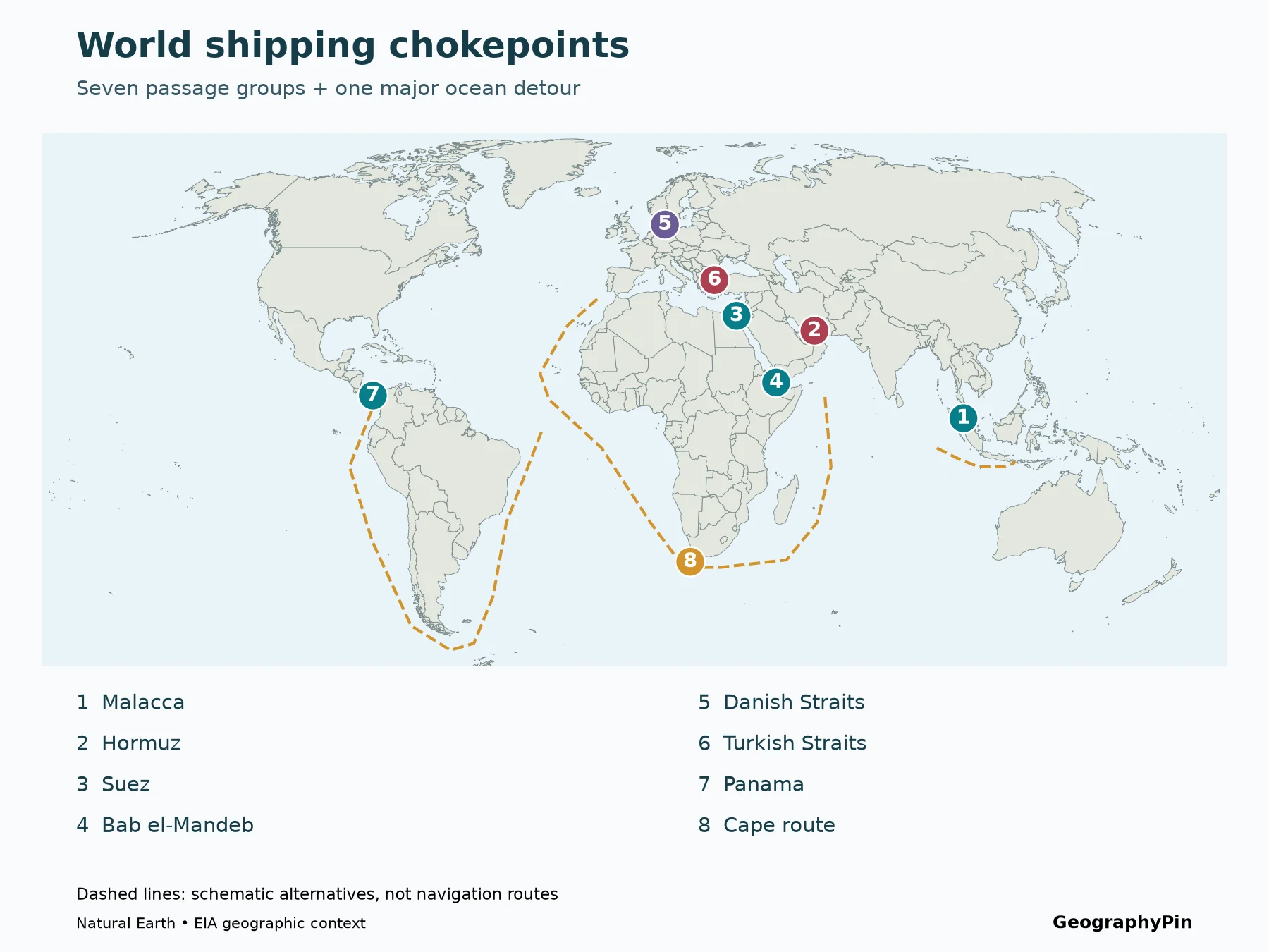
1. World shipping chokepoints map

The numbered key
- Malacca: between the Malay Peninsula and Sumatra.
- Hormuz: the Persian Gulf’s entrance beside Iran and Oman.
- Suez: the canal across Egypt; SUMED is a separate pipeline.
- Bab el-Mandeb: the southern gateway of the Red Sea.
- Danish Straits: the Baltic’s connections toward the North Sea.
- Turkish Straits: the Bosporus–Marmara–Dardanelles chain; marker at the Dardanelles.
- Panama: the canal linking the Caribbean and Pacific.
- Cape route: the open-ocean detour around southern Africa.
This is a selected global comparison based on the passage groups in the U.S. Energy Information Administration’s oil-transit analysis, not a list of every important strait. Gibraltar, Dover and many other passages also matter to shipping. The selection lets us compare geography with a consistent published energy dataset without pretending it measures all world trade.
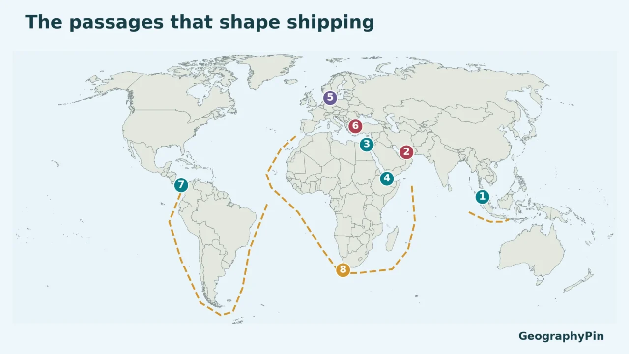
Marker colors distinguish broad bypass situations: teal for major sea-detour examples, red for basin gateways without another direct ocean-going sea exit, purple for the Danish passage system and its constrained canal alternative, and gold for the Cape route itself. A colored dot describes geography, not whether a route is open today.
2. What each passage connects
| Map number and passage | Waters connected | Geographic distinction |
|---|---|---|
| 1. Malacca | Andaman Sea and the Indian Ocean toward the Singapore Strait and South China Sea | A corridor between Sumatra and the Malay Peninsula, not a canal across land. |
| 2. Hormuz | Persian Gulf and Gulf of Oman | The Gulf of Oman leads to the Arabian Sea; another ocean detour cannot create a second outlet from inside the Persian Gulf. |
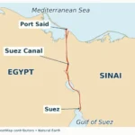
| 3. Suez | Mediterranean Sea and Red Sea via the Gulf of Suez | An artificial ship canal. SUMED carries crude oil across Egypt separately. |
| 4. Bab el-Mandeb | Red Sea and Gulf of Aden | The Gulf of Aden opens toward the Arabian Sea. |
| 5. Danish Straits | Baltic Sea toward the Kattegat, Skagerrak and North Sea | A system of passages, rather than one single channel. |
| 6. Turkish Straits | Black Sea, Sea of Marmara and Aegean Sea | Bosporus joins Black Sea to Marmara; Dardanelles joins Marmara to Aegean. |
| 7. Panama | Caribbean Sea and Pacific Ocean | The Caribbean is part of the Atlantic system; locks and inland channels cross the isthmus. |
| 8. Cape route | Atlantic and Indian Ocean approaches around southern Africa | An open-ocean detour, not a narrow strait. |
A route can contain several chokepoints in sequence. A ship sailing from a Persian Gulf port to Mediterranean Europe may encounter Hormuz, Bab el-Mandeb and Suez during the same voyage. That sequence makes a regional map more useful than treating each passage as an isolated dot.
The reverse also matters: not every ship in one passage uses the next. A cargo can load or discharge at a Red Sea port, or reach that coast by pipeline. The volumes at Suez and Bab el-Mandeb therefore need not match, even though the two gateways appear along the same broad corridor.
3. Three kinds of bypass
A ship bypass and a cargo bypass are different
A sailing detour keeps the cargo aboard a ship but follows a different sea route. The Cape route can replace the Red Sea–Suez corridor for suitable voyages between the Indian Ocean and Atlantic or Mediterranean destinations. Around South America, Cape Horn and other southern passages can replace a Panama crossing for some origin–destination pairs. The alternative remains a voyage, often a much longer one.
A cargo-transfer or pipeline alternative moves the goods by another mode for part of their journey. SUMED carries crude oil between Egypt’s Red Sea and Mediterranean sides; it does not carry ships or containers through the land. Likewise, an oil pipeline to a terminal outside Hormuz does not provide an alternative sea entrance for a vessel already inside the Persian Gulf.
No other direct sea exit describes a basin’s shape, not the absence of every possible supply-chain workaround. Hormuz is the Persian Gulf’s only direct sea outlet. The Turkish Straits are the Black Sea’s ocean-going route to the Mediterranean. Inland waterways, pipelines and land transport do not function as an equivalent open-ocean passage for the same ships.
| Passage | Alternative type | Why it is not a simple replacement |
|---|---|---|
| Malacca | Sailing detour via Sunda, Lombok or a wider Indonesian route | Distance, draft and passage conditions differ; not every ship can use every strait. |
| Hormuz | Selected oil pipelines to terminals outside the Gulf | Commodity, connections and available capacity limit the substitute; the ship itself does not bypass the strait. |
| Suez / Bab el-Mandeb | Sailing around Africa; SUMED for eligible crude-oil movements across Egypt | The Cape adds distance; SUMED does not bypass Bab el-Mandeb for an approach from the Gulf of Aden. |
| Danish Straits | Different straits within the system; Kiel Canal for suitable vessels | Channel and canal limits matter. Kiel is not a universal substitute for deep-draft tankers. |
| Turkish Straits | Some cargo can use pipelines or land connections to other ports | No second equivalent sea outlet connects the Black Sea with the Mediterranean. |
| Panama | Sailing around South America or other long routes; some oil by pipeline | The best detour depends on endpoints; canal size and water constraints are distinct from ocean-route constraints. |
4. Regional maps and route constraints
Africa: a detour changes the whole voyage
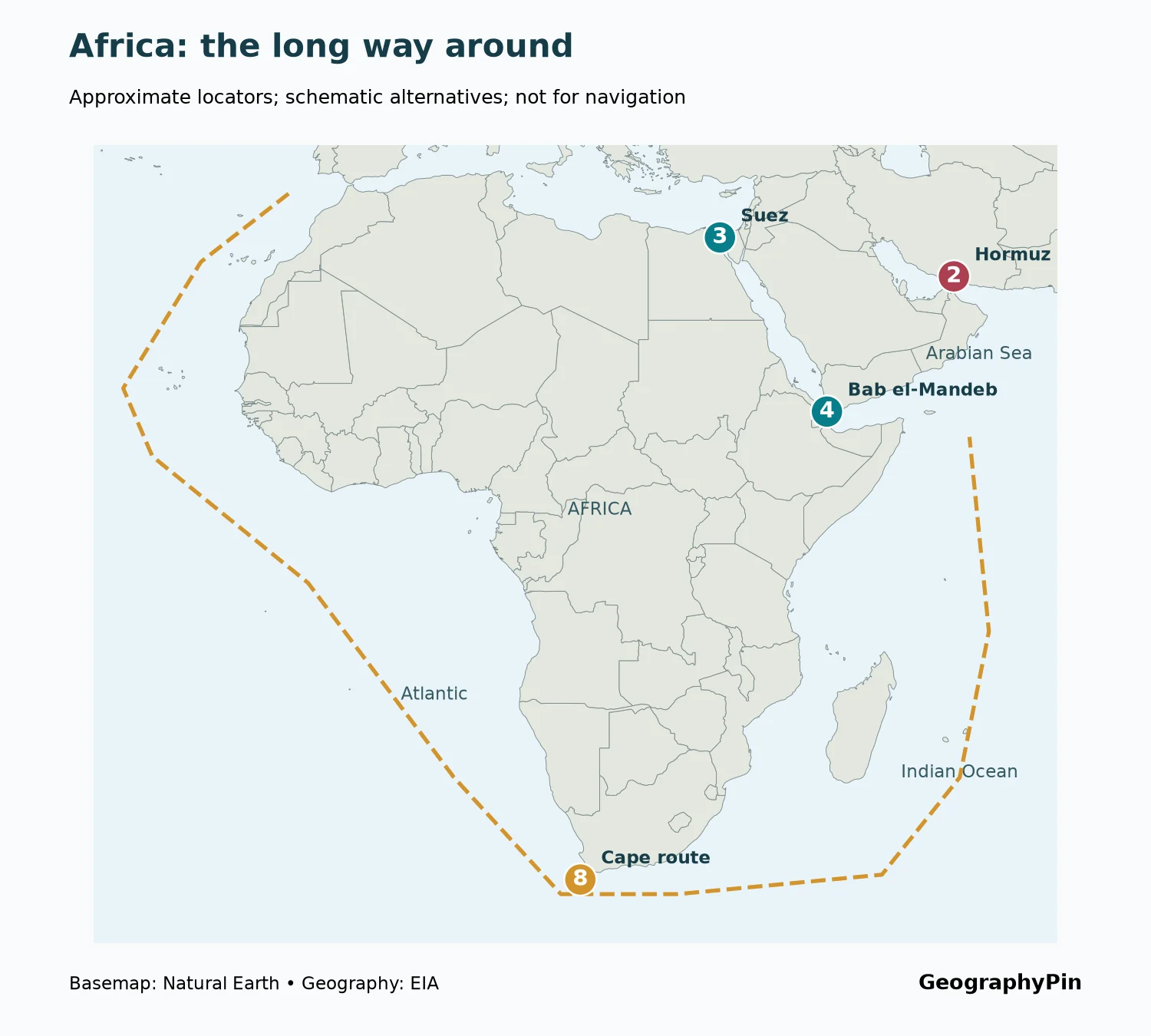
Avoiding the Suez–Red Sea corridor means going around a continent, not taking a nearby parallel strait. The extra distance depends on where the ship starts and finishes. A single “days added” number is not valid for every voyage, because speed, weather, stops and endpoints differ.
A Cape detour also does not solve every disruption. A ship starting inside the Persian Gulf still needs to pass Hormuz before it can choose a route across the Indian Ocean. A ship calling at a Red Sea port may have different options from one merely transiting the entire corridor. Geography limits what the word “bypass” can promise.
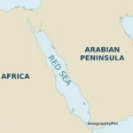
Use the Red Sea map for the basin’s regional layout and the Suez Canal map for the canal’s position. The world comparison here keeps those regional details separate from the broader choice of routes.
Southeast Asia: another strait is still a strait
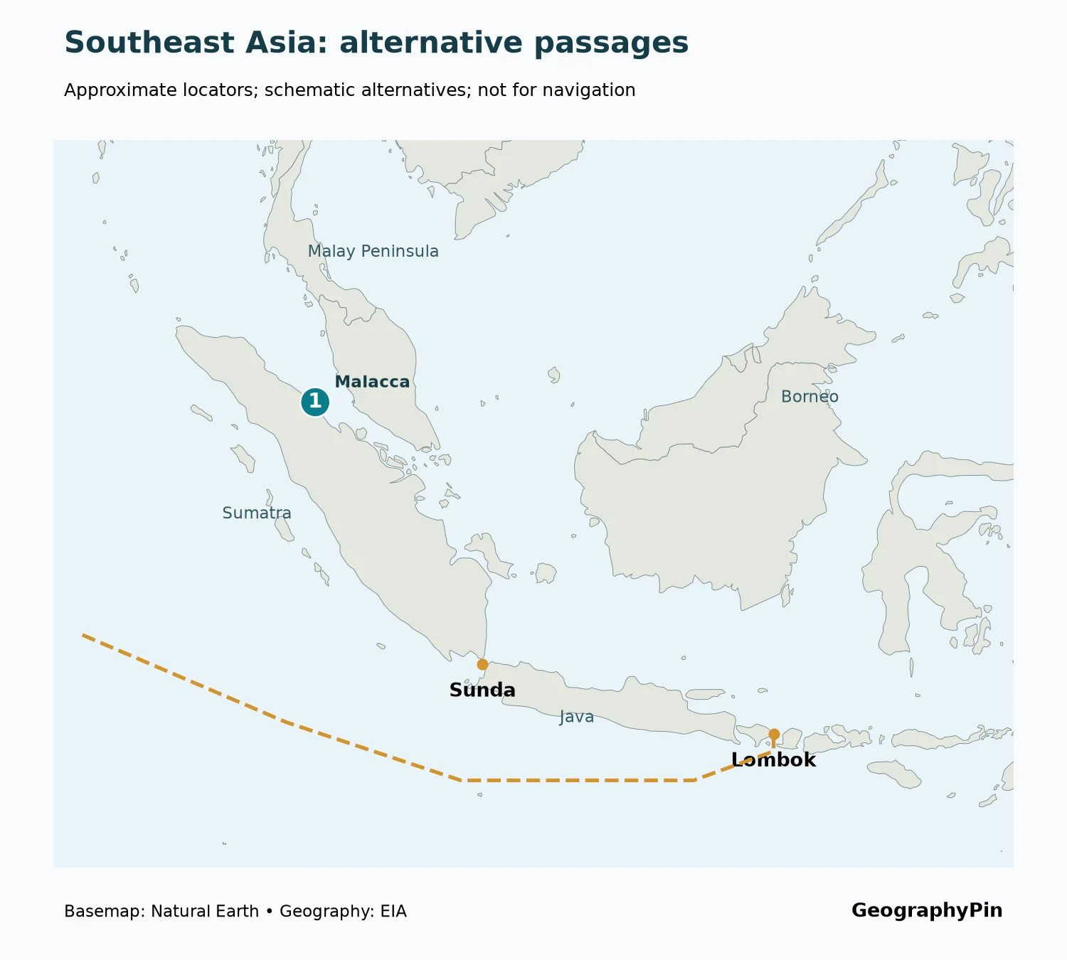
Malacca’s alternatives do not remove the Indonesian archipelago from the voyage. They move the crossing to a different passage. Sunda and Lombok have different physical constraints and approach routes; a route suitable for one ship may not suit another. The relevant dimensions include draft, beam and the navigable channel, not merely the width between two coastlines on a world map.
This is why a straight line drawn across islands would be misleading even on a schematic map. The graphics retain the islands and use offshore lines, while stopping short of presenting a navigable track or claiming a universal shortest alternative.
Panama: locks, water and the shape of two continents
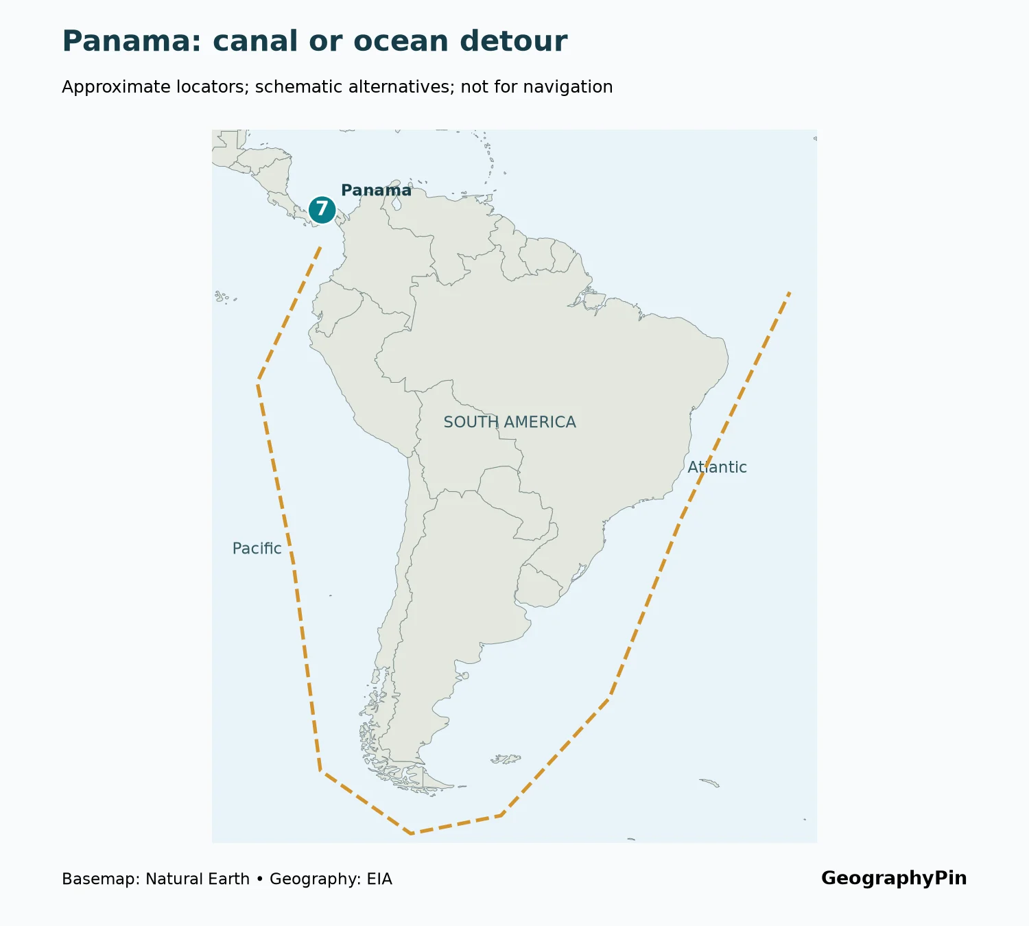
Panama is a constructed crossing through an isthmus, not a naturally open strait. Its locks use water to raise and lower ships, and the canal authority’s operating limits and booking information matter alongside vessel dimensions. Drought can therefore affect capacity without the landform itself changing.
The alternative is not automatically the same for every ship. A voyage between the two coasts of the Americas and a voyage from the U.S. Gulf Coast to Asia may favor different rerouting choices. Cargo-transfer options also require compatible terminals and transport links; they cannot be assumed from the map alone.
Europe: distinguish a system from its components
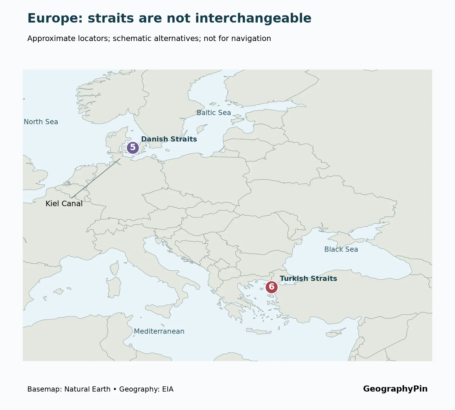
The Danish Straits connect the Baltic to the Kattegat and onward toward the North Sea. Kiel Canal crosses northern Germany and can shorten the journey for suitable vessels, but its dimensions prevent it from replacing the straits for every ship. EIA’s Danish-Straits figure excludes Kiel, so they should not be silently combined.
The Turkish Straits are a connected sequence: Bosporus, Sea of Marmara and Dardanelles. Some traffic uses only part of that sequence. Calling a Dardanelles measurement a measurement of every Bosporus movement would lose that distinction. The geography and the measurement location need to stay paired.
5. Oil flows: a dated comparison
April–June 2026, not a live traffic counter
The comparison below uses the second quarter of 2026 (April–June) from EIA’s Global Energy Security Data supplement released August 12, 2026. It measures crude oil and petroleum liquids in million barrels per day. It does not measure container traffic, total cargo tonnage, the value of trade or the number of ships.
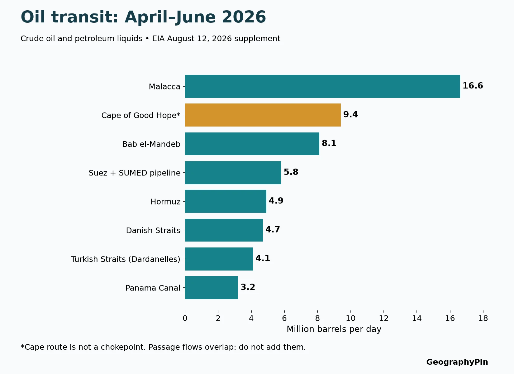
| Passage or route | Million barrels per day | Scope note |
|---|---|---|
| Malacca | 16.6 | Oil, not all maritime trade |
| Cape of Good Hope | 9.4 | Open-ocean comparison route |
| Bab el-Mandeb | 8.1 | Southern Red Sea gateway |
| Suez Canal and SUMED pipeline | 5.8 | Combined ship-canal and pipeline measure |
| Hormuz | 4.9 | Estimated passage flows |
| Danish Straits | 4.7 | Kiel Canal excluded |
| Turkish Straits (Dardanelles) | 4.1 | Dardanelles measurement, not a Bosporus total |
| Panama Canal | 3.2 | Use this quarterly series, not the separate fiscal-year table |
EIA combines tanker-tracking evidence with analysis and other sources. Tracking can be incomplete, and the supplement specifically discusses uncertainty around Hormuz after late February 2026, including missing or unreliable vessel signals. The figures are estimates subject to revision, not an exact count of every barrel. They should not be presented as today’s conditions.
6. Why the volumes cannot be added together
Suppose one shipment crosses Hormuz, Bab el-Mandeb and Suez. It contributes to three passage counts, but it is still one shipment. Adding those counts together would count the same cargo more than once. The resulting number would not be a meaningful estimate of global oil trade.
There is another mismatch in the Suez row: EIA combines the ship canal with SUMED pipeline movements. The combined figure is useful for an energy-corridor comparison, but not as a stand-alone measure of ship traffic in the canal. Likewise, comparing a quarter with a fiscal-year total or combining oil and LNG quantities would mix incompatible measures.
The right interpretation is comparative and local: how much of the specified commodity passed the specified location in the specified period? To assess a route’s vulnerability, pair that measurement with the available alternatives. A smaller flow through a hard-to-replace basin outlet can pose a different problem from a larger flow through a passage with several feasible detours.
Frequently Asked Questions
Does a shipping chokepoint have to be a natural strait?
No. A ship canal can also concentrate traffic into a constrained passage. Suez and Panama are artificial waterways, while Hormuz and Malacca are natural straits. Their operating constraints are therefore not identical.
Why are pipeline flows included beside sea passages?
The EIA comparison follows oil-transport corridors, not ships alone. SUMED can move crude oil across Egypt between the Red Sea and Mediterranean sides. That is useful energy context, provided the combined Suez–SUMED label remains explicit.
Does the largest oil-flow number identify the most important route for every cargo?
No. Oil is only one cargo group. Container shipping, dry bulk and LNG have different route patterns, vessel needs and measurement units. This chart cannot rank all shipping from a single oil series.
Can these maps tell me whether a passage is safe or open today?
No. They explain stable geographic relationships and schematic alternatives. Current restrictions, security conditions, port access and canal operating notices require the responsible authorities and up-to-date maritime information.
What Did We Learn Today?
A shipping chokepoint becomes easier to understand when we connect the map to the available bypass: a longer voyage, a different transport mode or no equivalent direct sea outlet. The Cape route can replace some canal-and-strait journeys, but cannot create a second exit from an enclosed gulf. Dated oil-flow figures add context only when their commodity, period and measurement location remain clear, and overlapping passage counts must never be added into a global total.
Sources & Data Notes
- EIA Global Energy Security Data: August 12, 2026 supplement, Table 2 and passage tables; second-quarter 2026 oil figures and tracking methodology.
- EIA World Oil Transit Chokepoints: geographic connections and alternatives, March 3, 2026 edition. Its older annual and half-year flow tables are not mixed with the quarterly chart here.
- Panama Canal Authority customer information: vessel scheduling, restrictions and current operating notices.
- Natural Earth: public-domain 1:50m country outlines used as the basemap.
- EIA reuse policy: source acknowledgment; no EIA logo, licensed tracking imagery or third-party photographs reproduced.
Map method: GeographyPin created the cartography from Natural Earth outlines and rounded editorial locators checked against EIA’s regional geography. World maps use a Robinson projection; regional graphics use longitude and latitude for orientation, not distance measurement. Dashed alternatives are manually drawn schematic ocean approaches, not AIS tracks, official shipping lanes, shortest paths or live route recommendations. Point symbols identify passage groups, not precise navigation waypoints. The Cape symbol is offshore to represent the route, not the position of the headland.
Data limits: Figures are EIA estimates of crude oil and petroleum liquids in million barrels per day. Suez includes SUMED, Danish Straits exclude Kiel, and the Turkish measurement is at the Dardanelles. Totals may differ from rounded components. No global total is calculated from overlapping passage counts. Source releases and current operating notices can supersede the dated information shown here.