Zimbabwe’s uplands, lower valleys and eastern mountains explain more than a single average elevation can.
Zimbabwe is a landlocked country in southern Africa, with Harare as its capital. Its Highveld contrasts with lower Middleveld and Lowveld landscapes and the mountains of the Eastern Highlands. The Zambezi borders Zambia to the north, while the Limpopo marks the boundary with South Africa to the south.
How to use this article: Locate the country on the map, read the physical map, explore rainfall seasons, or check the population reference.
1. Locate Zimbabwe and Its Neighbors
Landlocked between four neighboring countries
Zimbabwe lies in southern Africa, bordering Zambia, Mozambique, South Africa and Botswana. It has no coastline.
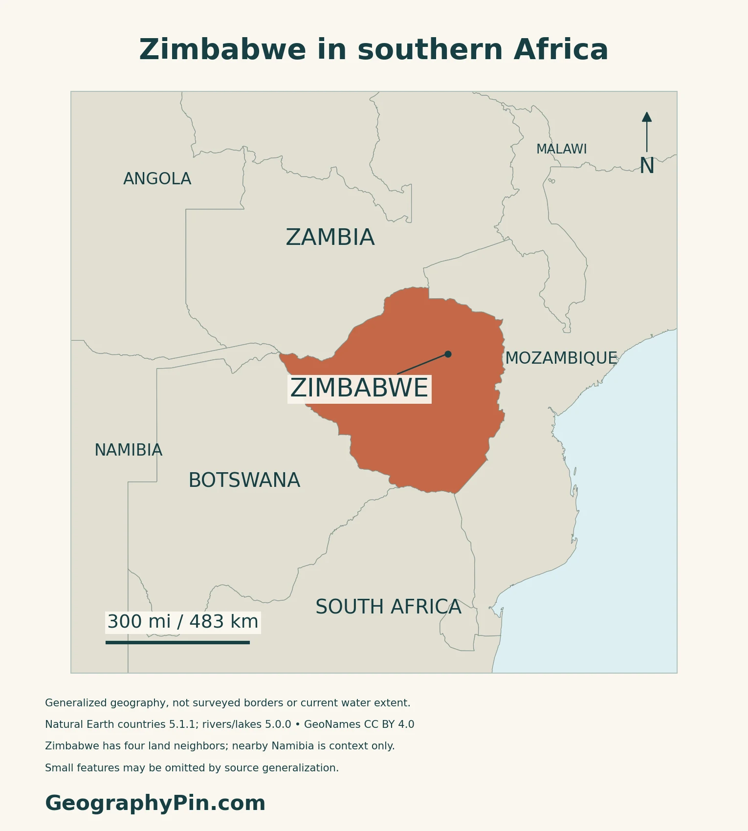
Harare is the capital; Parliament sits at Mount Hampden
Harare remains the national capital. Parliament lists its location as Mount Hampden; the location of that institution does not make Mount Hampden a replacement national capital.
2. Compare the Highveld, Lowveld and Eastern Highlands
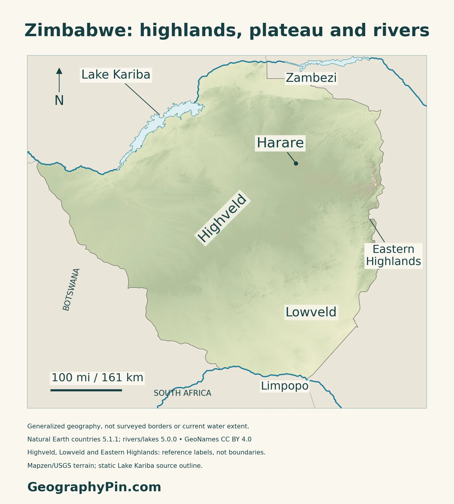
Read relative relief, not four administrative territories
| Landscape | Position and character | Map-reading distinction |
|---|---|---|
| Highveld | Higher central plateau country | Upland does not mean a uniformly level surface |
| Middleveld | Intermediate ground around the uplands | A transition rather than a provincial boundary |
| Lowveld | Lower country, especially toward the southeast | Generally warmer than the higher interior |
| Eastern Highlands | Mountain belt near Mozambique | Separate from the central plateau |
| Zambezi valley | Lower northern border landscape | Not an extension of the high central interior |
Elevation thresholds depend on the classification
FAO’s national overview identifies four broad physical regions. Older agricultural references use different elevation cutoffs for the veld categories, so this map labels geographic settings rather than drawing supposedly exact regional borders.
3. Follow the Border Rivers and Reservoir
Two major rivers frame different sides of the country
The Zambezi and Limpopo are important boundary rivers, but their drainage basins extend beyond Zimbabwe. FAO’s Limpopo basin study covers parts of Botswana, Mozambique, South Africa and Zimbabwe; a country outline is not a catchment boundary.
The original maps show selected river courses rather than every tributary or a complete basin division.
Kariba is a reservoir, not a live storage reading
Lake Kariba is shared with Zambia on the Zambezi. The Zambezi River Authority describes a dam and reservoir supporting power stations on both banks. Its engineering table separates reservoir dimensions from generating capacity.
Victoria Falls belongs to a wider river landscape
UNESCO’s Mosi-oa-Tunya / Victoria Falls property spans Zambia and Zimbabwe. Its significance includes the basalt gorges as well as the waterfall itself.
For the full downstream sequence and the distinction between the river and its wider basin, see the existing Zambezi River map and guide.
4. Connect Seasonal Rain with Farming
Higher and lower landscapes do not share one climate
A historical FAO account by Zimbabwean agricultural engineer H. A. Elwell describes wetter eastern highlands and drier southern lowlands, with rain concentrated in the warmer part of the year.
FAO’s Limpopo basin assessment also emphasizes rainfall variability and evaporation in the southern basin. A seasonal total alone does not describe the timing of dry spells or how much water remains available to crops.
Dryland farming and irrigation require different approaches
Zimbabwe’s Department of Research and Specialist Services describes its Semi-arid Lowveld Research Institute around Chiredzi, Chisumbanje and Save Valley. Its work combines soil and water management for dryland smallholder production with irrigation research, including small gardens and commercial cropping.
Do not reduce the country to one export crop
FAO’s country overview identifies maize, sorghum and wheat among staple crops, and cattle, goats and poultry as important rural assets.
5. Dated Country Facts and Institutions
| Item | Reference | Date or scope |
|---|---|---|
| Capital | Harare | National capital |
| Population | About 16.18 million | ZIMSTAT principal projection for 2026 |
| Surface area | About 150,872 sq mi (390,757 km²) | UNData reference year 2023; not land-only |
| Languages | Sixteen languages expressly recognised | Constitution, section 6 |
| Currency | Zimbabwe Gold (ZiG), alongside permitted foreign currencies | Multicurrency context; RBZ references checked in November 2026 |
| Government | Republic | Constitutional framework, with amendments checked |
| Administration | Ten provinces, including two metropolitan provinces | Constitution, section 267 |
A projected total is not a new enumeration
ZIMSTAT’s 2022–2042 report gives a principal projection of 16,175,966 for 2026. It uses the final 2022 census population of 15,178,957 as its base without adjustment, then models fertility, mortality and international migration. The projection is a national total, not a count of Zimbabwean citizens living worldwide.
Recognition extends beyond the most widely used languages
Section 6 names Chewa, Chibarwe, English, Kalanga, Koisan, Nambya, Ndau, Ndebele, Shangani, Shona, sign language, Sotho, Tonga, Tswana, Venda and Xhosa. It requires equitable treatment of officially recognised languages and allows legislation to recognise others.
Harare and Bulawayo are metropolitan provinces within the ten-province framework. These administrative units are different from the Highveld, Lowveld and other physical regions.
ZiG does not mean foreign currencies have disappeared
RBZ’s foreign-exchange guidance permits foreign currencies alongside ZiG. Its October 2026 update describes a future transition to a single currency as conditional and market-driven, not an already completed change.
What Did We Learn Today?
Zimbabwe’s higher interior, eastern mountains and lower valleys create contrasting settings for water and farming. The Zambezi and Limpopo connect it to neighboring countries, while the map’s physical regions should not be confused with administrative boundaries.
Sources & Data Notes
Population references retain their dates and census or projection methods. Physical-region labels are geographic references, not provincial boundaries or exact elevation-band polygons. Historical FAO accounts support broad relief and seasonal contrasts, not current climate normals, farming-zone totals or forecasts. Kariba engineering information is not a live storage or electricity-output reading. The short Victoria Falls summary does not replace the full Zambezi guide.
- ZIMSTAT: 2022 census-based population projections, 2022–2042, methods and 2026 principal scenario
- UNData: Zimbabwe, surface area reference year 2023 and capital
- Zimbabwe Constitution: officially recognised languages and provincial framework, sections 6 and 267
- Parliament of Zimbabwe: constitutional resources and Mount Hampden address
- Government Printer: Constitution of Zimbabwe Amendment (No. 3) Act, 2026, original Act reproduced by Law.co.zw
- Parliament: September 29, 2026 address confirming constitutional amendment enactment
- Reserve Bank of Zimbabwe: August 2025 foreign-exchange guidelines, multicurrency provisions
- Reserve Bank of Zimbabwe: October 6, 2026 update on conditions for a future single currency
- FAO Zimbabwe: national physical-region and agricultural overview
- H. A. Elwell, Institute of Agricultural Engineering, Harare: historical relief and seasonal-climate background, published by FAO
- Zimbabwe FOSA country report, FAO-hosted historical background: alternative veld elevation convention, not current forestry statistics
- FAO: Limpopo River Basin biophysical assessment; historical climatology, not a current forecast
- Zimbabwe Department of Research and Specialist Services: Lowveld dryland and irrigation research
- Zambezi River Authority: Kariba engineering reference, not live storage
- UNESCO: transboundary Mosi-oa-Tunya / Victoria Falls property
Map method: Original GeographyPin maps use public-domain Natural Earth countries 5.1.1 and rivers/lakes 5.0.0. Supplied Zambezi and Limpopo courses are retained without invented channels. Lake Kariba is a static source polygon, not present water extent or an allocation ruling. Highveld, Lowveld and Eastern Highlands are broad references, not administrative or surveyed landform boundaries. GeoNames supplies Harare’s coordinate under CC BY 4.0. Real Mapzen Terrain Tiles provide relief with Mapzen/USGS and upstream credits. Lake water overlays terrain; an isolated negative artifact is transparent rather than assigned an invented height. WGS84 scales apply locally. The cover uses the generalized country outline and the public-domain-tagged Commons flag rendition, preserving a complete separate flag.