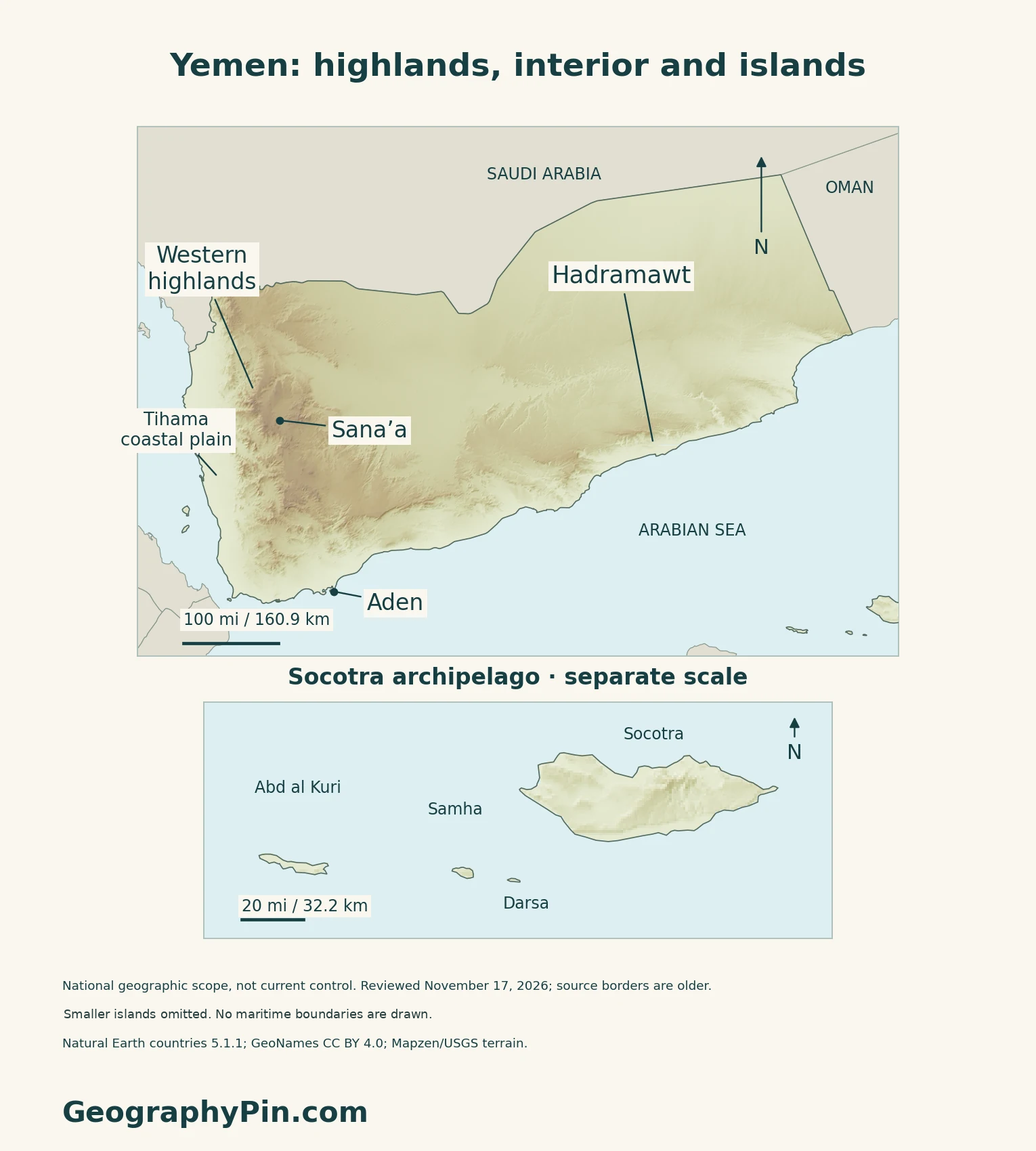
Yemen’s geography is more varied than the desert image often associated with southern Arabia. Western mountains rise behind coastal plains, while the interior opens toward plateaus and desert; Socotra adds a separate island setting offshore. Reading the country therefore requires both an elevation map and a clear distinction between mainland and archipelago.
Elevation is a major reason: Yemen’s low coastal plains are generally hotter, while higher mountain areas are cooler. Rainfall also varies sharply, with wetter western slopes giving way to a much drier interior. Coastal farming can draw on runoff arriving through wadis from uplands, rather than on abundant local rain.
How to use this article: Locate the country, compare the physical settings, or explore Socotra.
1. Locate Yemen and Compare Its Main Landscapes
Mainland and offshore islands
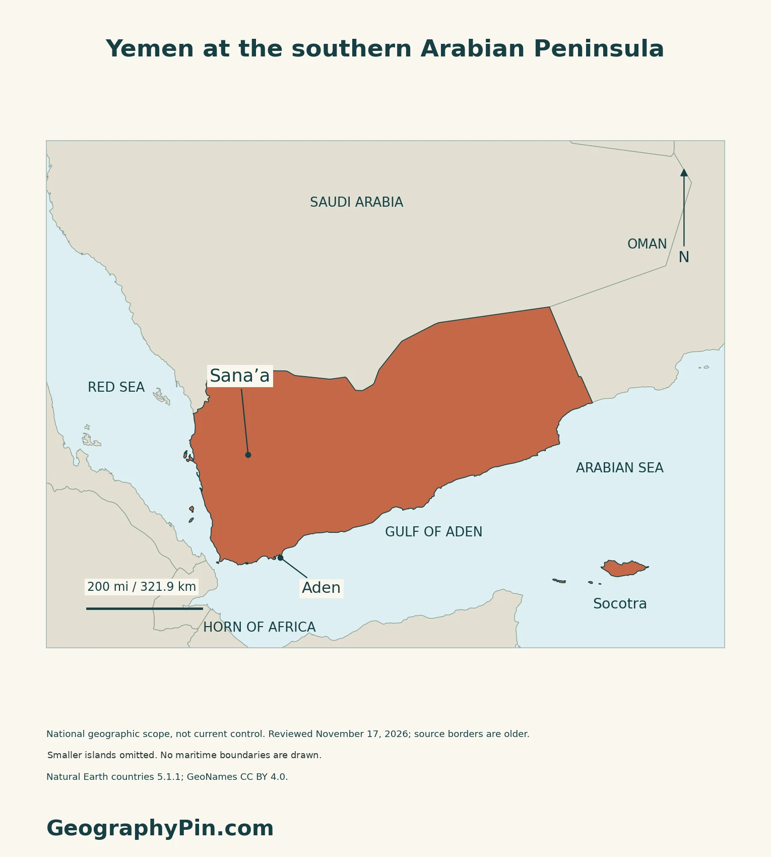
Yemen occupies the southwestern Arabian Peninsula, adjoining Saudi Arabia and Oman. The Red Sea lies west of the mainland, with the Gulf of Aden and Arabian Sea along its southern side. Socotra is offshore, not an extension of the mainland coast.
For regional orientation, see the Middle East countries map. This profile uses physical geography, not shifting front lines, to organize the country.
Four mainland settings to recognize
| Setting | Reading the landscape |
|---|---|
| Coastal plains | Low, hot terrain below the uplands. |
| Western mountains | Steep slopes and deeply divided relief. |
| Eastern plateau | Broad uplands descending toward desert and coast. |
| Northeastern desert | An arid inland setting, distinct from the mountains. |
2. Understand Rainfall Beyond a Single Average
Seasons, elevation and observation gaps
A December 2023 UNDP-commissioned study describes two main mainland rainy periods, broadly in spring and late summer, while showing that their importance varies across the country. A national annual average cannot explain the conditions of every slope, plain or island.
The study also identifies major gaps in ground observations and difficulties resolving rainfall over complex terrain. Its climate scenarios explore possible futures; they are not forecasts of the weather in a particular town.
3. Read Terraces and Wadis as Water Systems
Why water may arrive from elsewhere
Highland terraces are not simply decorative steps. The FAO/WFP’s 2009 assessment explains how their banks slow runoff and erosion, helping retain moisture in cultivated soils. This is a description of the farming mechanism, not a claim that every terrace is maintained or productive today.
On the Tihama and other coastal plains, wadi runoff can carry water from higher-rainfall uplands. The place receiving the water and the place receiving the rain need not be the same.
4. Keep Socotra Distinct From the Mainland
An archipelago, not just one island
UNESCO describes the Socotra Archipelago as four islands and two rocky islets in the northwestern Indian Ocean near the Gulf of Aden. Socotra is also the name of its largest island, so the two usages should not be confused.
The World Heritage listing emphasizes exceptional biodiversity and endemism: many plants and animals occur naturally nowhere else. Its protected property and the entire archipelago are not identical geographic units.
5. Check Dated Country Facts
| Item | Reference |
|---|---|
| Capital reference | Sana’a, named in Article 157 of the constitutional text |
| Population reference | About 41.774 million; UN medium-fertility projection for July 1, 2025 |
| Area reference | About 203,850 sq mi (527,968 km²); UNData surface-area figure dated 2023 |
| Official language | Arabic, specified in Article 2 |
| Currency | Yemeni rial (YER) |
| Administrative reference | 22 governorate-level reporting units in WHO’s August 2025 report, including Sana’a City and Socotra |
A projection, not a new census
The UN figure is a projected de facto population, not a count of Yemeni citizens worldwide. UNSD’s January 2026 census table still lists December 2004 as the latest available national census. World Population Prospects combines census evidence with demographic adjustments and subsequent fertility, mortality and migration information.
The projection should therefore not be read as a fresh enumeration during the conflict. Refugee and internally displaced-person figures describe different populations or circumstances; they cannot simply be added to the national reference.
Capital names and divided institutions
Sana’a’s constitutional designation is distinct from the location of government institutions. A September 16, 2025 Foreign Ministry statement calls Aden the interim capital. A January 30, 2026 UN statement distinguishes de facto authorities in Sana’a from the internationally recognized government.
These dated references do not establish a single authority exercising effective control throughout Yemen. The profile uses capital and administrative names for geographic orientation, not as a current control map or an assurance about access or safety.
For a broader comparison, see the Asian countries and capitals reference.
What Did We Learn Today?
Yemen’s coastal plains, western mountains, eastern plateau and northeastern desert have contrasting terrain and rainfall. Wadis carry upland runoff toward coastal farming areas, while Socotra is a distinct offshore island setting. Geographic maps do not show current access or political control.
Sources & Data Notes
Sources, dates and map conventions
Population follows the UN’s July 2025 projection, not a new national census. UNData’s technical notes define its surface-area convention as excluding inland water. Constitutional provisions are cited narrowly for capital and language; the WIPO compilation’s appended 2015 declaration is not treated as a universally accepted current settlement. The WHO units are a dated reporting framework, not newly verified legal boundaries. Historical FAO geography and the 2009 FAO/WFP assessment are used for terrain and water-management mechanisms, not present-day population, administration, crop output or access. The December 2023 climate study is a dated analysis, not a local forecast. UNESCO’s island-group description and heritage scope are kept distinct.
- UNData: Yemen, dated population, area and currency references
- UNData technical notes: population and surface-area conventions
- UN World Population Prospects 2024: Yemen data sources, printed page 277
- UNSD Population and Vital Statistics Report, January 2026: Yemen census reference
- WIPO-hosted constitutional compilation: Articles 2, 156 and 157; not a claim of unified present governance
- Yemen Foreign Ministry, September 16, 2025: Aden described as interim capital
- UN Yemen, January 30, 2026: distinction between de facto authorities and internationally recognized government
- WHO HeRAMS Yemen, August 2025: governorate reporting framework
- FAO historical Yemen geography: qualitative terrain only
- FAO/WFP, December 9, 2009: terraces and runoff mechanisms
- UNDP-commissioned study, December 2023: climate and evidence limitations
- UNESCO: Socotra Archipelago World Heritage property
- UNEP-WCMC Socotra datasheet: island identity and location only
Original maps: Natural Earth public-domain countries 5.1.1 and GeoNames CC BY 4.0 coordinates; Mapzen/USGS terrain. All nine source Yemen land components appear in the cover and locator; four Socotra-group outlines are enlarged at a separate scale. Smaller islands and rocky islets are omitted, so polygon count is not a political island inventory. No World Heritage, maritime or current-control boundaries are shown. Regional labels are reference locations, not mapped extents. Review date November 17, 2026 is not the source survey date. All 402 negative terrain samples inside the generalized land mask were withheld transparently, including coastal and inland values; this nonnegative subset does not establish an absence of below-sea-level land. No heights were invented and no exact summit or bathymetric measurements are claimed. The complete Flagpedia rendition is reusable; its red-white-black design and 3:2 proportions agree with the Foreign Ministry’s flag description.