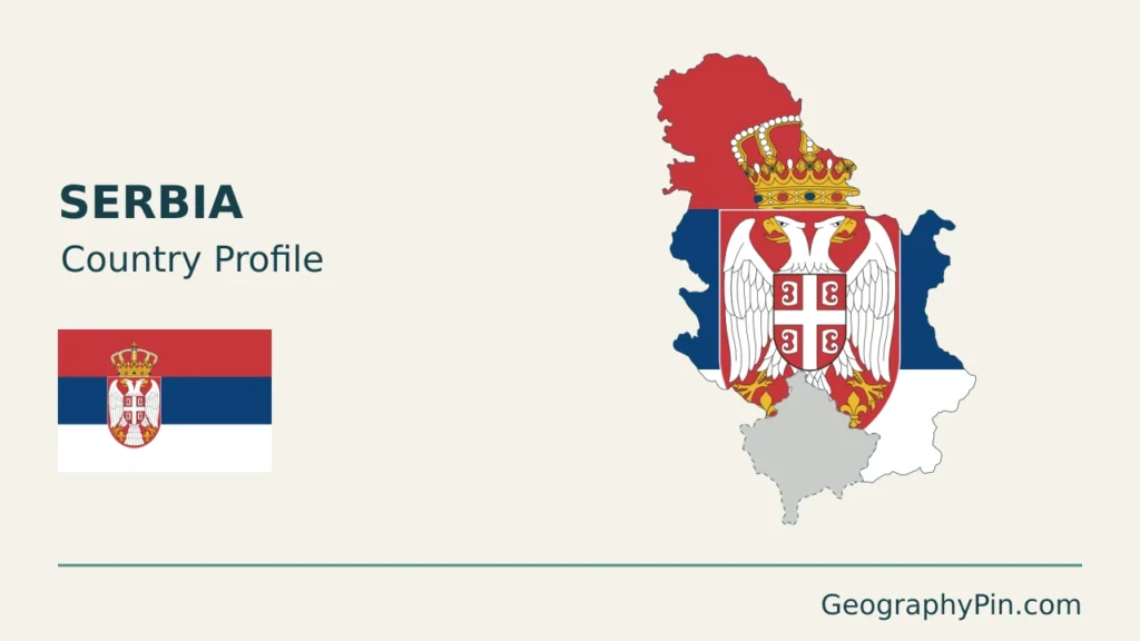
Serbia’s northern plains and southern uplands meet through a network of river valleys. Belgrade stands at the confluence of the Sava and Danube, while the Morava system reaches into the interior. That geography helps explain the country’s transport corridors, farming landscapes and settlement. Its maps and statistics also require a clear distinction between Serbia’s claim to Kosovo and Kosovo’s separate effective administration.
Serbia is a landlocked country in central and southeastern Europe. Belgrade is its capital. Vojvodina occupies much of the low-lying Pannonian north, while central and southern landscapes combine hills, basins and mountain ranges. The Sava, Tisza and Morava connect with the Danube, linking inland catchments to the Black Sea. Kosovo’s disputed status requires separately stated map and statistical coverage.
How to use this article: Check statistical coverage, compare the main landscapes, or follow the river connections.
1. Locate Serbia and understand the map
Serbia lies between the southern Pannonian Basin and the interior of the Balkans. Hungary is to the north, Romania and Bulgaria to the east, and Croatia, Bosnia and Herzegovina and Montenegro to the west and southwest. North Macedonia lies to the south; Kosovo is shown separately as disputed-status context on the accompanying maps.
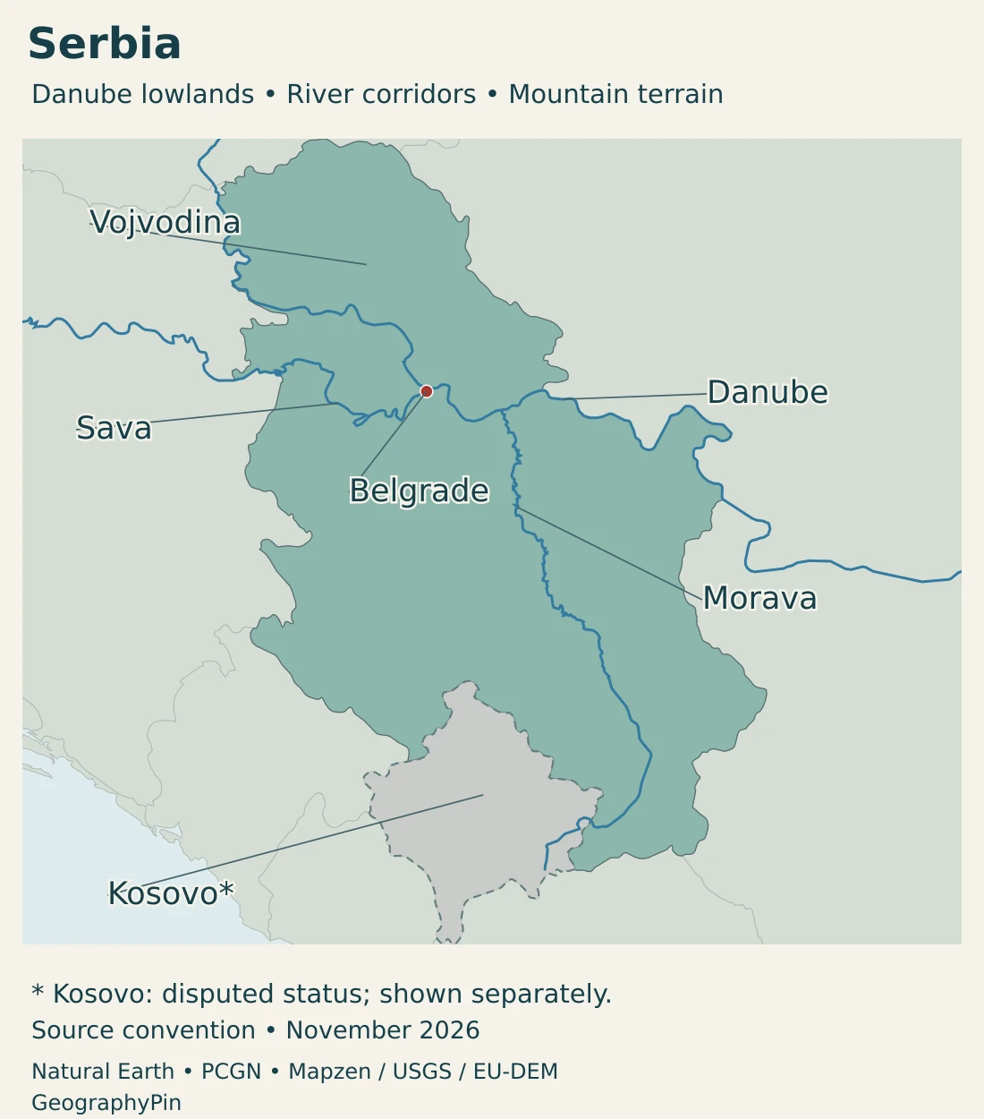
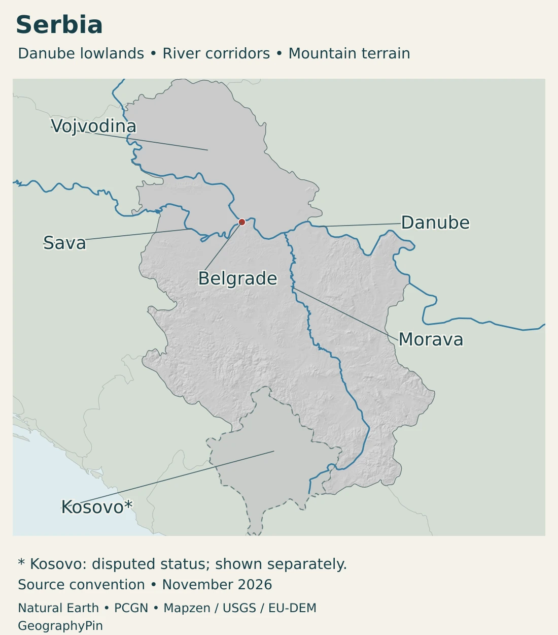
The lowlands extend beyond national borders. Vojvodina is part of a much larger basin, not an isolated plain surrounded on all sides by Serbian mountains. Farther south, river valleys run among hills and uplands rather than forming a uniformly high plateau.
The Balkan countries map gives the broader regional setting. Our Danube River map follows the international river beyond Serbia.
Kosovo declared independence in 2008 and has its own institutions. Serbia continues to claim it and does not recognize its independence; international recognition is not universal. Separate treatment on these maps distinguishes effective administration from Serbia’s claim rather than presenting the dispute as settled.
2. Country facts and statistical coverage
| Fact | Value | Date or meaning |
|---|---|---|
| Capital | Belgrade | At the Sava–Danube confluence. |
| Population | 6,532,019 | Estimated December 31, 2025 population; excludes Kosovo. |
| Area excluding Kosovo | About 29,957 square miles (77,589 km²) | Calculated from the statistical office’s January 1, 2025 regional table. |
| Official language and script | Serbian and Cyrillic | Other languages and scripts may have official use under law. |
| Currency | Serbian dinar (RSD) | National Bank law, Article 53. |
| Government | Republic with parliamentary government | The National Assembly legislates; the Government exercises executive power. |
Read the population and area with their coverage
The population estimate in the table excludes Kosovo. Serbia’s published geographical tables also contain a Kosovo regional entry, so their headline national area has a different scope. The area used here is calculated by subtracting that entry, with both source figures retained in the data notes.
This distinction is not a declaration about sovereignty. It makes clear which population and geographical coverage the numbers describe. A map of effective administration, a constitutional claim and a statistical reporting area need not have identical outlines.
No population density is calculated from a mixture of these territorial definitions. The estimate’s reference date also differs from the date when the statistical office published it.
3. Pannonian plains, hills and mountains
Compare the main landscape settings
| Setting | Landscape | How to read it |
|---|---|---|
| Pannonian north | Extensive lowlands crossed by the Danube, Tisza and other waterways. | Vojvodina is an administrative province within this broader physical setting. |
| Central hills and basins | Rolling terrain and valleys around the Morava system. | Valley floors and surrounding uplands have different settlement and land-use patterns. |
| Western and southern uplands | Mountain ranges, plateaus and enclosed basins. | A mountain label identifies a broad landscape, not a single continuous wall. |
| Eastern Danube and mountain country | The Danube passes through the Đerdap gorge system beside Romania. | An international river can cross a confined gorge as well as an open plain. |
Đerdap shows the Danube in a mountain setting
Đerdap, also known as the Iron Gates, contrasts sharply with the open northern lowlands. Here the Danube occupies a gorge between Serbia and Romania, connecting the Pannonian setting to the west with the lower-basin landscapes farther east.
The UNESCO Global Geopark includes the national park and parts of the Miroč and Kučaj massifs. Rock exposures, caves, natural arches and springs reveal a varied geological landscape. The geopark designation is not a name for the entire Danube basin or all of eastern Serbia.
The same river therefore supports very different scenes along its course: broad lowland channels, urban waterfronts and constricted mountain passages. A single photograph of Belgrade or Đerdap cannot represent every Serbian river landscape.
4. Danube connections and continental climate
The Sava, Tisza and Morava meet the Danube system
The Sava joins the Danube at Belgrade. The Tisza reaches the Danube in the northern lowlands, while the Velika Morava brings water from the central and southern interior. These are connected catchments, not separate rivers ending at Serbia’s borders.
The Serbian Morava system should not be confused with the Morava/March farther upstream in Austria. Both names occur on Danube-basin maps, but they refer to different tributaries and different parts of Europe.
The Danube continues downstream to the Black Sea. Serbia consequently has an inland-waterway connection to the sea without possessing a seacoast. Navigation channels, river basins and political boundaries are different features: a basin includes land drained by tributaries, not only the visible main channel.
Relief modifies a broadly continental climate
Serbia has a broadly moderate-continental climate, with substantial local differences. Elevation, slope orientation, valleys and wider atmospheric circulation influence temperature, precipitation and wind. Northern plains do not experience the same conditions as higher mountain terrain.
The national meteorological service describes generally greater precipitation at higher elevations and a colder-season snow cover. Its older climate-normal tables are historical reference periods, not today’s forecasts or current temperature records.
River valleys can channel air as well as water. The combination of open lowlands and more enclosed uplands helps explain why one national average is a limited guide to a particular place. Weather for an individual journey still depends on season, elevation and current conditions.
5. Belgrade, regional cities and languages
Belgrade is a confluence city
Belgrade’s position at the Sava–Danube meeting gives the capital an immediate connection to two major waterways. Riverfront geography is part of its setting, while its administrative territory and built-up urban area are not interchangeable statistical units.
Novi Sad is another important Danube city in Vojvodina. Farther south, Niš belongs to a different, more enclosed valley setting. Comparing these locations is more informative than imagining every major settlement as a small version of the capital.
The statistical office estimates 6,532,019 residents at the end of 2025, excluding Kosovo. This is not a new census count. It follows the 2022 census with demographic updates; the source’s annual-average population is a separate figure. Regional or municipal totals should not be mistaken for the population of a continuously built-up city.
Official language provisions and everyday diversity
The Constitution establishes Serbian and the Cyrillic script in official use, while official use of other languages and scripts is regulated by law. That legal framework is different from a claim that only one language or alphabet appears in daily life.
Language, citizenship and ethnic identification are separate categories. A constitutional language provision does not imply that everyone has the same mother tongue. Regional language use and minority-language rights also cannot be inferred simply from a national map.
6. Government and the geography of work
Serbia is a republic with parliamentary government. The National Assembly exercises legislative authority, while the Government holds executive authority and is directed by the prime minister. Vojvodina’s provincial status is an administrative distinction; it is not a synonym for every part of the wider Pannonian landscape.
Lowland farming and hill-country orchards
The geography of agriculture is not uniform. Serbia’s government summary of the 2023 agricultural census identifies Vojvodina as having the largest share of arable land and gardens, while Šumadija and Western Serbia have the largest share of orchards.
This contrast connects farming to the difference between extensive lowlands and more varied hill country. It does not mean that all northern land is cultivated or that every southern community depends on orchards. Towns, industry, woodland and other land uses coexist within these broad regions.
Waterways connect a diversified economy
Serbia’s inland-waterways authority identifies the Danube, Sava and Tisza as international waterways. These connections help place a landlocked country within a wider network of European freight routes. River access is one part of that network, rather than a substitute for roads, railways or land-border crossings.
The statistical office’s preliminary 2025 national accounts identify manufacturing, trade and information and communication among major economic activities. The country is therefore not adequately described only through its agricultural landscapes.
The geographic picture brings these elements together: northern lowlands, river junctions, central valleys and mountain districts, linked by transport and economic activity but differentiated by terrain and settlement. Clear territorial notes keep that physical account separate from contested political claims.
Frequently Asked Questions
Does Serbia have a coastline?
No. Serbia is landlocked. The Danube provides an inland-waterway connection to the Black Sea, which is different from having a seacoast.
Which rivers meet at Belgrade?
The Sava joins the Danube at Belgrade. Their confluence is a defining feature of the capital’s geographic setting.
Does the population figure include Kosovo?
No. The Serbian statistical estimate used here excludes Kosovo. The area calculation and map notes state their coverage separately because territorial claims and statistical reporting are not the same thing.
What Did We Learn Today?
Serbia combines a Pannonian lowland north with more varied hills, basins and mountains farther south. Belgrade stands where the Sava meets the Danube, while the Morava connects the interior to that river system. Population, area and maps must state their treatment of Kosovo rather than silently mixing different territorial definitions.
Sources & Data Notes
Population excludes Kosovo. The geographical area is explicitly derived from the statistical office’s regional table: 88,499 minus 10,910 equals 77,589 km². It is not a separately published national total or a claim about sovereignty. Conversions are rounded. Political recognition, effective administration and statistical coverage are treated separately; no density is calculated from mixed definitions.
- Statistical Office of Serbia, Estimated population 2025: December 31 estimate 6,532,019, released July 1, 2026. Based on the 2022 census, natural change and internal migration; Kosovo is excluded. The annual-average figure is a different measure.
- Statistical Office of Serbia, geographical and territorial table: January 1, 2025 regional area table: 88,499 km² headline total includes a 10,910 km² Kosovo entry. Subtraction gives 77,589 km² excluding Kosovo; no separate land/water accounting is inferred.
- Constitutional Court, Constitution of Serbia: Capital, language and script, parliamentary and executive responsibilities; Serbian territorial claims are distinguished from effective administration.
- UK Parliament, Kosovo: developments since 1999: Declaration of independence, separate institutions and non-universal recognition; no recognition count is presented as current.
- Serbian Ministry of Foreign Affairs, February 17, 2026 statement: Evidence of Serbia’s continuing non-recognition position, not endorsement of the statement’s other allegations.
- European Commission, Kosovo: Separate institutional relationship and status-qualified treatment.
- Serbia, First Biennial Transparency Report 2024: Broad physical regions. The report’s claimed-territory area and mountain rankings are not substituted for the coverage explained here.
- Directorate for Inland Waterways, international waterways: Sava–Danube confluence and Danube, Sava and Tisza waterway connections.
- UNESCO, Djerdap Global Geopark: Gorge setting between Serbia and Romania, mountain massifs and geological heritage.
- Republic Hydrometeorological Service, basic climate characteristics: Qualitative terrain and climate relationships; the numerical normals refer to 1961–1990 and are not current weather or records.
- Government of Serbia, agriculture: Regional land-use contrasts summarized from the 2023 agricultural census.
- viadonau, Lower Morava floodplain restoration: The Morava/March in the upper Danube basin is distinct from the Serbian Morava system.
- National Bank of Serbia, Law on the National Bank: Article 53 identifies the dinar as legal tender.
- City of Niš, urban heat-island assessment, 2025: University assessment describing the Nišava valley and surrounding mountain setting.
- Statistical Office of Serbia, GDP 2025: Preliminary 2025 national accounts released October 1, 2026; manufacturing, trade and information and communication.
Map sources and scope: Original GeographyPin maps use public-domain Natural Earth country outlines, city coordinates, rivers and lakes. The complete Serbia source geometry is retained and Kosovo is rendered separately in neutral gray. Separate depiction does not adjudicate sovereignty or portray Serbia’s full territorial claim. Generalized boundaries are not an official survey or a current-control map. The November 2026 label dates this presentation, not a new boundary observation.
Belgrade uses Natural Earth city-coordinate attributes. Vojvodina is a broad regional locator from the PCGN Serbia Toponymic Factfile, September 2022, not a drawn provincial boundary. No administrative or physical-region polygons are invented. The Danube, Sava and Morava lines are selected from actual source river records intersecting the Serbia outline; this excludes the unrelated Morava farther upstream in central Europe. Lake and river geometry does not represent navigation channels or current water levels.
Hillshade is calculated from genuine elevations accessed through Mapzen Terrain Tiles, with no vertical exaggeration. Global elevation data courtesy of the U.S. Geological Survey. Produced using Copernicus data and information funded by the European Union – EU-DEM layers. Elevation-source attribution and terms apply. Shading is not bathymetry or numerical elevation bands. Neutral styling of Kosovo is a cartographic distinction, not an indication that it lacks mountains.
The cover uses national flag artwork from Commons. The intact flag retains its 3:2 proportions and appears separately from the decorative outline motif; Kosovo is not filled with the Serbian flag.