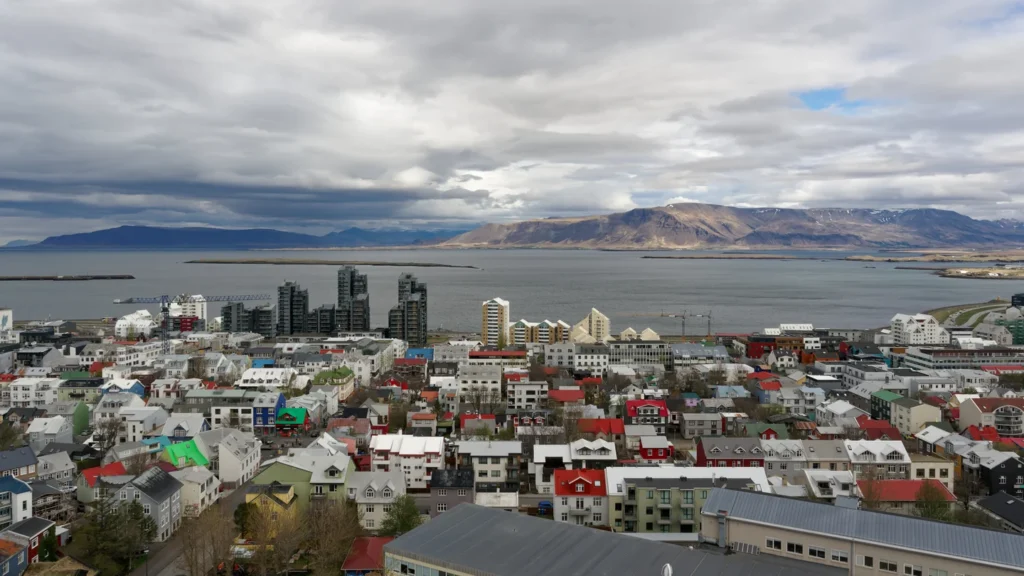
Near Reykjavík’s old harbour, the next town can feel like the next neighbourhood. Follow the city boundary north across the bay, though, and Reykjavík also takes in farms, a smaller village and mountain slopes.
Reykjavík is on Faxaflói Bay in southwestern Iceland. The capital’s old harbour sits on the southern shore of an arm of the bay, with Esja across the water. On 1 January 2026, the Reykjavík municipality counted 139,804 residents, while the continuous built-up area that stretches from Hafnarfjörður to Mosfellsbær counted 247,162.
Where the capital meets Faxaflói Bay
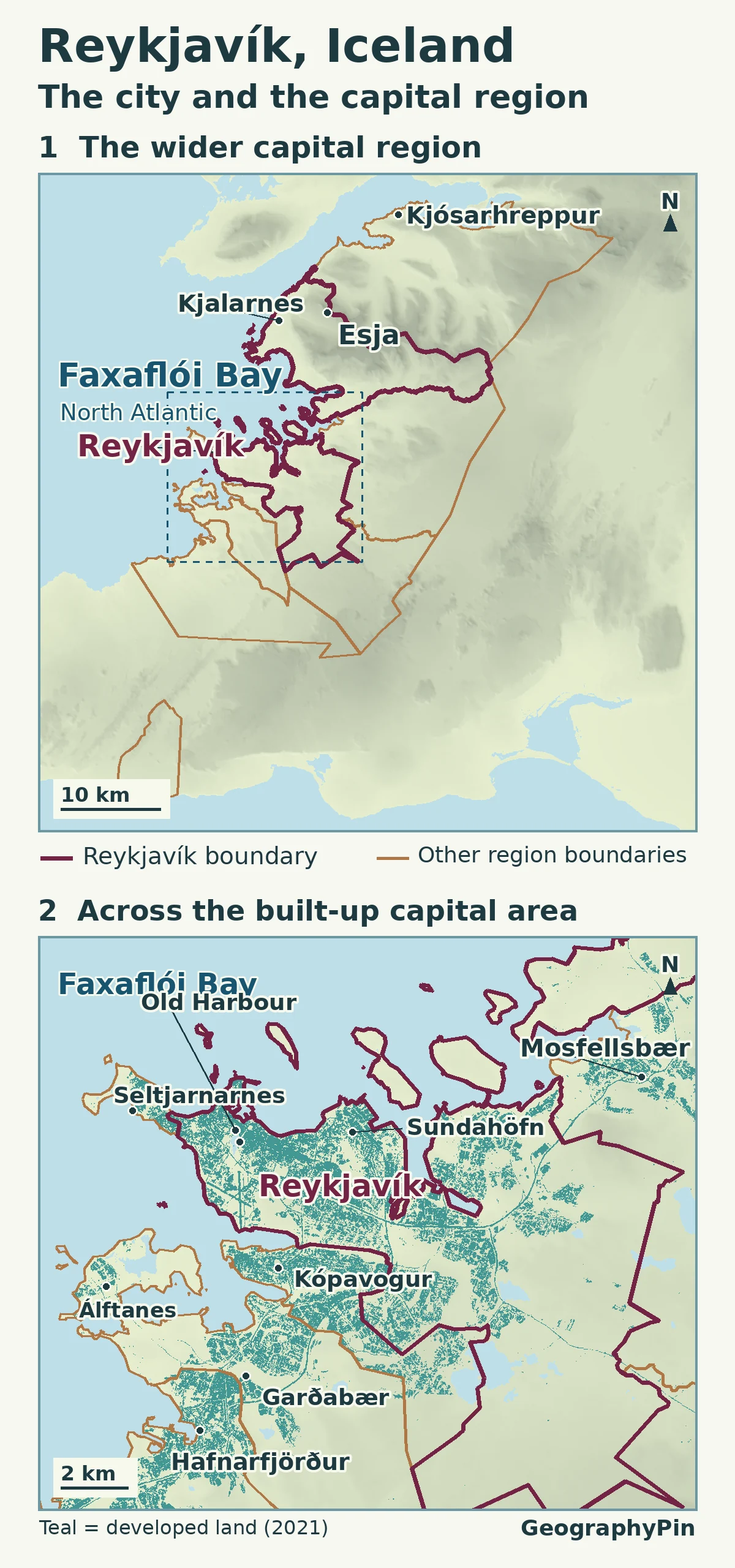
Start with the wide view of southwestern Iceland. Faxaflói opens west toward the North Atlantic, but the old centre of Reykjavík faces a more sheltered inlet. Esja, the broad mountain mass visible across the water from the city, belongs to the same landscape even though it looks separate from downtown.
The close-up locates two harbour areas. The Old Harbour is beside the historic centre. Sundahöfn lies farther east, beyond the Laugarnes headland, with working freight facilities and passenger berths in the port authority’s guides. The two are part of the same port operation, but looking for freight docks beside the central waterfront gives the wrong picture of how the shoreline is used.
Why Reykjavík reaches across the water
The Reykjavík boundary covers more than the grid of streets around the Old Harbour. Beyond the built-up city, it extends into the Esja landscape and Kjalarnes on the northern side of the bay. Kjalarnes was a separate municipality until its merger with Reykjavík in 1998. Its village of Grundarhverfi is part of the city government’s planning area, but it is not an extension of downtown’s street grid. Statistics Iceland counts it as a separate locality.
The opposite example is Seltjarnarnes, near downtown on the west end of the peninsula. Much of the built shoreline looks continuous, yet the municipality changes before the tip. Taking the municipal boundary as a shortcut for “where the city streets end” fails in both directions: it includes noncontiguous places in the north and excludes adjoining streets in neighboring towns.
One built-up area, several local governments
On the close-up, Reykjavík’s developed neighborhoods continue toward Kópavogur, then farther south through Garðabær toward Hafnarfjörður. Mosfellsbær lies in the other direction, toward the head of the bay. Between these places are inlets, green areas and less developed ground. Continuity is about how one settlement connects to the next, not paving over every gap.
The Capital Region includes seven municipalities: Reykjavík, Kópavogur, Seltjarnarnes, Garðabær, Hafnarfjörður, Mosfellsbær and Kjósarhreppur. The region also includes land and communities the statistics office does not place within its Greater Reykjavík locality. For instance, Álftanes is part of the Garðabær municipality but has a separate entry in the locality table. So even within one suburban municipality the two sets of boundaries do not necessarily coincide.
Three official ways to count Reykjavík
| Geographic unit | Residents | What the boundary means |
|---|---|---|
| Reykjavík municipality | 139,804 | One local government, including Kjalarnes |
| Greater Reykjavík locality | 247,162 | Connected settlement spanning municipal lines |
| Capital Region | 251,912 | Sum of seven municipalities, including less developed areas |
Statistics Iceland groups nearby addresses to delineate localities; its 2025 boundary update used a maximum separation of 200 metres and required at least 10 inhabited addresses for a settlement core. That approach answers a different question from a commuting-based metro area. In the 2026 tables, the locality held about 63% of Iceland’s 394,324 people, and the seven municipalities together held about 64%. Neither percentage refers just to Reykjavík city hall’s area.
Frequently Asked Questions
Do Reykjavík’s urban population boundaries change every year?
Statistics Iceland normally redraws urban boundaries every five years, in years ending in 0 or 5. An annual count can change even when the mapped area does not. When comparing distant years, check whether the boundary or calculation method changed as well.
Does the capital region include the whole of Faxaflói Bay?
No. Faxaflói is a physical feature, not a jurisdiction. The bay extends far beyond the capital-area municipalities. The close-up shows only the portion beside the continuous built-up area.
What Did We Learn Today?
On the Reykjavík map, the water, developed neighborhoods and municipal lines tell different stories. The city government reaches across the bay to Kjalarnes, while the main settlement runs south into adjoining towns. Keeping those boundaries apart helps explain why the population changes with the name you look up.
Sources & Data Notes
All counts refer to 1 January 2026. Capital Region is the sum of the seven municipal rows; it is not a commuting estimate. The shaded development is an independent land-cover observation, not the locality polygon.
- Statistics Iceland: 2026 resident population, municipality and locality tables MAN02005 and MAN030102, and 2025 boundary method and Greater Reykjavík extent.
- City of Reykjavík: municipal reference maps and Kjalarnes’ 1998 merger and Grundarhverfi. Faxaflóahafnir: Port Information Guide.
- Municipal boundaries: IS 50V Mörk by Landmælingar Íslands/Náttúrufræðistofnun, 1:50,000 January 2023 service edition, generalised; CC BY 4.0. Relief contains modified Copernicus DEM data (accessed 2026). Teal: © ESA WorldCover project 2021; contains modified Copernicus Sentinel data (2021) processed by the ESA WorldCover consortium (CC BY 4.0).
- Featured photograph: Jakub Hałun, View of Reykjavík from Hallgrímskirkja (May 2023), CC BY-SA 4.0; cropped and converted to WebP.