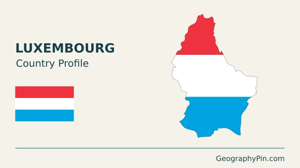
Luxembourg’s name can refer to a country, its capital or a neighboring Belgian province. The country itself is much more than an urban financial center: wooded northern uplands, sandstone valleys, former industrial districts and vineyards all fit within its borders. Its everyday connections also extend well beyond them.
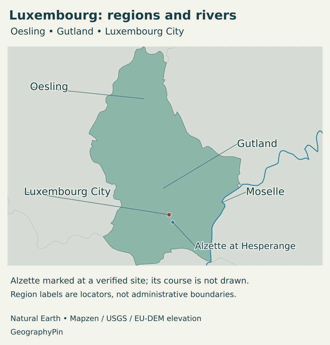
Luxembourg is an independent, landlocked country between Belgium, Germany and France. Luxembourg City is its capital and government seat. The northern Oesling forms part of the Ardennes, while the Gutland covers the center and south. Most rivers connect to the Rhine through the Moselle system, with smaller exceptions draining toward the Meuse.
How to use this article: Clarify the different uses of the name, compare uplands and southern landscapes, or explore cross-border commuting.
1. Locate Luxembourg: country, capital and namesake province
Luxembourg lies in western Europe, with Belgium to its west and north, Germany to the east and France to the south. It has no sea coast. Rivers and land routes connect it with the surrounding countries rather than isolating it from them.
The country, the city and the Belgian province
The Grand Duchy of Luxembourg is the sovereign state. Luxembourg City is a municipality within that state and its national capital. Belgium’s province of Luxembourg is a separate neighboring territory within Belgium, not part of the Grand Duchy.
The shared name reflects a larger historical territory. The 1839 settlement divided Luxembourg, with the western part going to Belgium and the eastern part continuing as the Grand Duchy. A modern map must distinguish those present-day jurisdictions rather than treating the historic name as one current boundary.
Our Europe country map provides the wider setting. The European countries and capitals guide distinguishes the state from its capital alongside the rest of the continent.
2. Country facts with dates and definitions
| Measure | Value | Date or definition |
|---|---|---|
| Capital | Luxembourg City | National capital and seat of government; not the whole country. |
| Population | 690,959 | STATEC resident population on January 1, 2026, based on the National Register of Natural Persons. |
| Published national area | About 998 sq mi (2,586 km²) | Rounded national total reported by Luxembourg’s government; published total area. |
| Languages | Luxembourgish, French and German | Luxembourgish is the national language; French is the legislative language; all three have administrative and judicial roles. |
| Currency | Euro (EUR) | Luxembourg belongs to the euro area. |
| Government | Parliamentary constitutional monarchy | Grand Duke as head of state; prime minister as head of government. |
| Local territorial organization | 100 municipalities; 12 cantons | Cantons are territorial units without their own administrative structure. |
The population total describes people resident in Luxembourg. It does not include every person who enters the country for work, and it is not limited to Luxembourgish citizens. Country, municipality, nationality and workplace statistics therefore measure different populations.
The area is a rounded government-published national figure. It should not be confused with the footprint of the capital, a wider commuting region or the study area of an environmental model.
3. Oesling uplands and the varied Gutland
Two broad regions, several different landscapes
| Setting | Landscape | Geographic importance |
|---|---|---|
| Oesling / Éislek | Northern Ardennes uplands with plateaus, wooded slopes and incised valleys. | A hillier northern setting with river valleys linking settlements. |
| Gutland / Guttland | Lower, undulating central and southern country. | Contains the capital and a mixture of farmland, woodland and developed areas. |
| Mullerthal / Mëllerdall | Sandstone rock formations, plateaus and narrow valleys in the east. | A distinctive geological landscape within the broader southern setting. |
| Moselle valley | An eastern river corridor associated with vineyards. | Combines border geography, cultivation and a navigable waterway. |
| Minett | Southern former iron-ore and steel landscapes. | Shows how industry and redevelopment reshape land use. |
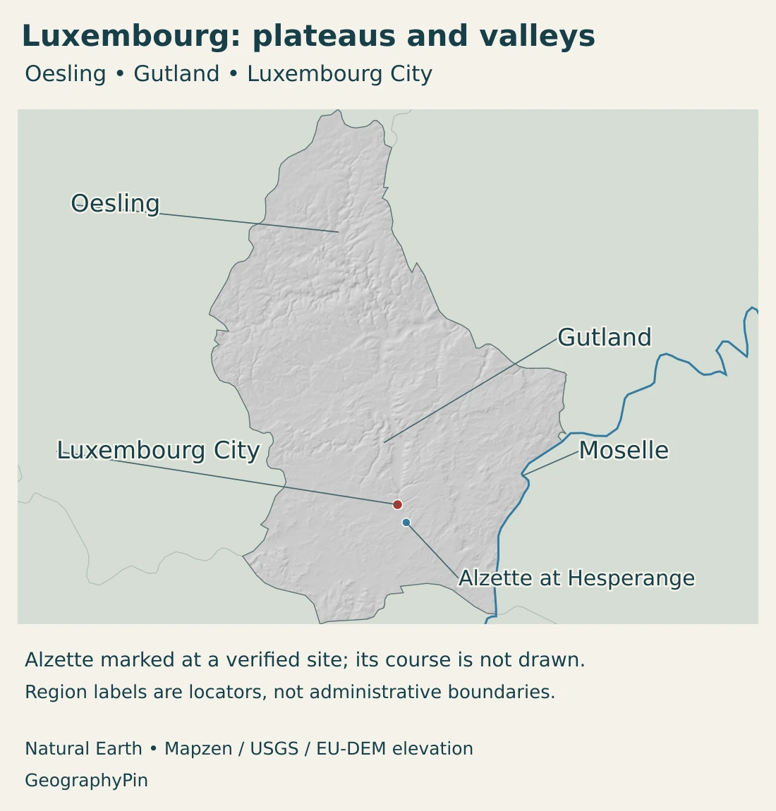
Oesling, also known as Éislek, belongs to the wider Ardennes landscape. Its plateaus are cut by river valleys, so a short distance on a map can involve a pronounced descent or climb. Woodland and open upland country alternate rather than forming one continuous forest.
Gutland is often described as lower, rolling country, but that does not mean it is a flat plain. Valleys, rock outcrops and local slopes remain important. The capital’s own topography is a useful reminder that the national north–south contrast is only a starting point.
Why Mullerthal looks different
Mullerthal gives the broad regional description a concrete geological example. Sandstone, marl, limestone and dolomite record ancient sedimentary environments. Subsequent erosion produced plateaus, valleys and exposed rock faces.
Some narrow clefts formed as sandstone blocks separated and moved over underlying marl. Weathering added further detail to the rock surfaces. These processes help explain why a relatively small area can contain steep cliffs and narrow passages beside more gently rolling land.
The landscape is not simply a miniature mountain chain. Its appearance reflects the arrangement of different rock layers and the way water and weathering act on them. A relief map shows the resulting shapes, while geology helps explain their origin.
The southern landscape also has an industrial history
The Minett is associated with iron ore and steelmaking. Former industrial land has acquired new urban, cultural and conservation uses, making the south a landscape of both inherited infrastructure and redevelopment.
Belval is a particularly visible example. Preserved blast furnaces stand beside a transformed district that includes the University of Luxembourg’s campus. The contrast is not between an industrial past and an empty present, but between successive uses of the same place.
4. Climate, rivers and cross-border water
Luxembourg has a sub-Atlantic climate, with generally moist, temperate conditions. Local terrain and land cover still matter: a sheltered valley, an exposed plateau and a built-up district do not experience weather in exactly the same way.
National environmental research also examines urban heat. Built-up places can remain warmer than their surroundings at night, especially during calm summer conditions. This is a local climate effect, not evidence that the whole country shares the temperature measured in its capital.
Most water reaches the Moselle and Rhine
The Sûre, also known as the Sauer, and the Alzette are important parts of Luxembourg’s river network. Most of the country’s rivers ultimately feed the Moselle and therefore belong to the Rhine system.
There are exceptions. The Chiers and its tributaries drain toward the Meuse, and a small northern stream, the Fooschtbaach, reaches that system through the Ourthe in Belgium. It is therefore more accurate to say “mostly Rhine-connected” than “entirely in the Rhine basin.”
The Moselle is also an engineered navigation corridor. Its role differs from that of a small upland stream, even though both belong to the same wider drainage network.
A river border is not always a line down the middle
Sections of the Our, Sûre and Moselle along the German border form shared German–Luxembourg territory, known as a condominium. The water administration describes joint responsibility for these boundary rivers.
This is a useful caution when reading a small-scale national map. A generalized border line locates the relationship between countries; it cannot explain every legal detail of ownership across a river’s width.
Water management also extends beyond sovereignty. Upstream land use, river engineering and conditions elsewhere in a catchment can influence downstream places. Luxembourg’s water geography is consequently inseparable from its neighbors.
5. Settlement, languages and daily movement
The capital sits above and within river valleys
Luxembourg City developed around a steep rocky site near the meeting of the Alzette and Pétrusse. The terrain contributed to its defensive importance. Fortifications and lower quarters still make the relationship between topography and urban history visible.
The old quarters and fortifications are a UNESCO World Heritage property, not a designation covering the entire country. The modern city extends beyond that historic ensemble, and the municipality is only one part of the wider national settlement pattern.
Other towns and rural municipalities matter too. Northern settlements occupy the Oesling’s valley-and-plateau landscape, while the south includes the urban and industrial setting around Esch-sur-Alzette. A capital-centered view would miss both.
Three languages with different legal roles
Luxembourgish is the national language. French is the language of legislation, while Luxembourgish, French and German are used in administrative and judicial matters. Those roles are more informative than a bare list of three languages.
The education system is multilingual, and residents also use other languages, including Portuguese and English. Legal language status is not a statement that every person has the same language background or uses the same language at home, school and work.
Residence and workplace extend across different maps
Workers living in France, Belgium and Germany form an important part of Luxembourg’s labor market. Official social-security statistics explicitly classify employment by the municipality and country where workers live.
A resident who works across the border remains part of the population of their home country. Conversely, employment in Luxembourg includes activity performed by people who do not live there. This helps explain why transport demand and workplace activity cannot be understood from the resident-population total alone.
The practical urban network therefore extends beyond the state boundary. Roads, rail links and daily journeys connect Luxembourg with neighboring areas, while the legal national borders remain in place.
6. Government and the changing economic landscape
Luxembourg is a parliamentary constitutional monarchy. The Grand Duke is head of state, the prime minister heads the government, and the Chamber of Deputies is the national legislature. The capital is also one of the official seats of European institutions, alongside Brussels and Strasbourg.
The country is divided into municipalities and cantons, but the cantons do not function as autonomous federal states. They are territorial units without their own administrative structure. Oesling and Gutland, meanwhile, are physical-geography terms rather than another layer of elected government.
From iron and steel to a wider service economy
Iron and steel were central to Luxembourg’s industrial development, especially in the south. Economic diversification later expanded finance and other activities. Financial services remain important, alongside logistics, digital technologies, research and other industries.
These activities connect a small domestic territory with much larger international networks. A financial office, a research campus and a former steel site have different land-use needs, but each relies on workers, infrastructure and connections beyond its immediate neighborhood.
Belval makes that transition tangible: preserved furnaces and a university campus occupy the same redeveloped district. It is a geographical change in the use of land and buildings, not merely a change in national economic statistics.
Luxembourg is best understood through both its internal contrasts and its external links. The northern uplands and southern urban landscapes remain distinct, while rivers, commuting and economic relationships connect the country to a much wider European region.
Frequently Asked Questions
Is Luxembourg a country or a city?
Both names exist: the Grand Duchy of Luxembourg is an independent country, and Luxembourg City is its capital. Belgium’s province of Luxembourg is a separate territory in Belgium.
What are Luxembourg’s main physical regions?
The northern Oesling, or Éislek, forms part of the Ardennes. The Gutland, or Guttland, covers the center and south and contains varied landscapes including the capital, sandstone country and the Moselle valley.
Does every river in Luxembourg belong to the Rhine basin?
No. Most rivers connect to the Rhine through the Moselle, but the Chiers system and a small northern drainage connection belong to the Meuse basin.
What Did We Learn Today?
Luxembourg is a country whose capital shares its name, not a city-state or part of Belgium. Oesling uplands contrast with the varied Gutland, while rivers connect mainly to the Rhine and partly to the Meuse. Multilingual institutions, cross-border commuting and the transformation of industrial land help explain how this small state functions within a wider region.
Sources & Data Notes
Reviewed in November 2026. Population is a January 2026 resident-register figure. The rounded area follows the national government’s published total. Resident population, people working in the country, the capital municipality and wider cross-border connections have different geographic scopes.
- STATEC, population on January 1, 2026: 690,959 residents, based on the National Register of Natural Persons; release created May 6, 2026.
- Luxembourg government, territory: Rounded national area of 2,586 km², capital and government seat, 100 municipalities and 12 cantons, and the historical territorial distinction from Belgium. Area is not a separately measured dry-land total.
- STATEC, territory and environment: Broad Oesling–Gutland relief contrast and qualitative sub-Atlantic climate.
- EURAXESS Luxembourg, geography: Northern Ardennes setting and the more densely settled south; qualitative settlement context.
- Luxembourg Education Ministry, languages: National, legislative, administrative and judicial language roles, and multilingual education.
- European Union, Luxembourg overview: Parliamentary constitutional monarchy, institutional roles, euro and European institutional seat.
- Water administration, hydrographic network: Moselle/Rhine connections and Meuse exceptions, navigation, and shared German–Luxembourg boundary rivers.
- Environment administration, regional climate analysis: Local urban heat and modeled summer-night climate contrasts; not a current weather forecast.
- Mullerthal regional tourism office, geological highlights: Sedimentary rocks, incision, sandstone block movement and weathering.
- Luxembourg Commission for UNESCO, geological heritage: Sandstone, valleys, plateaus and the relationship between geology and land use; qualitative geological description.
- UNESCO World Heritage Centre, Luxembourg City: Alzette–Pétrusse setting, defensive topography, historic quarters and fortifications.
- IGSS, employment by municipality of residence: Official dataset distinguishes employment in Luxembourg from residence in Luxembourg, France, Belgium and Germany; no undated commuter count is inferred.
- Luxembourg government, economic profile: Steel heritage, financial services and economic diversification; qualitative sector context.
- Luxembourg for Tourism, Belval: Preserved blast furnaces and the University of Luxembourg campus in the redeveloped southern district.
Map sources and scope: Original GeographyPin maps use public-domain Natural Earth country boundaries, populated-place coordinate attributes and river geometry. The complete Luxembourg source outline is retained. Generalized borders do not resolve detailed cadastral demarcation or the legal arrangements governing shared boundary rivers; these maps are not navigation charts.
Luxembourg City uses the source city coordinates. Oesling and Gutland are broad physical-region labels, not administrative boundaries. The Moselle follows the source river line. The Alzette is absent from that line dataset, so its course is not invented: a blue point instead marks the government’s verified Hesperange/Alzette gauge location, converted from its published national-grid coordinates. The marker identifies a place, not a current water-level measurement.
Hillshade is calculated from genuine elevations accessed through Mapzen Terrain Tiles, with no vertical exaggeration. Global elevation data courtesy of the U.S. Geological Survey. Produced using Copernicus data and information funded by the European Union – EU-DEM layers. Elevation-source attribution and terms apply. Shading is not bathymetry or a set of numerical elevation bands.
The cover uses Luxembourg flag artwork from Commons, by SKopp and contributors. The intact flag retains its source 5:3 proportions and appears separately from the decorative outline motif.
