Kenya crosses the equator, yet a highland morning in Nairobi does not feel like an afternoon on the Indian Ocean coast. Mountain slopes, Rift Valley floors, western lake country and dry northern plains create striking contrasts within one country. Understanding those differences explains much more than treating Kenya as a single tropical landscape.
Kenya is an East African country with Nairobi as its capital and an Indian Ocean coast. Its elevated central and western landscapes are generally cooler and wetter than much of the dry north and east. Altitude, mountain barriers, seasonal winds and access to moisture produce varied climates despite the country’s equatorial position.
How to use this article: Compare the four landscape settings, understand the highland climate contrast, or follow three different drainage routes.
1. Locate Kenya between the equator and Indian Ocean
Kenya lies in East Africa, with the Indian Ocean on its southeastern side. Its land neighbors are Tanzania, Uganda, South Sudan, Ethiopia and Somalia. The equator crosses the country, but latitude alone gives little indication of the elevation or rainfall at a particular place.
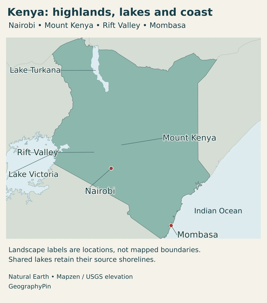
Nairobi is inland, south of the equator, in the elevated south-central part of Kenya. Mombasa is a coastal port. Kisumu lies beside Lake Victoria in the west. These locations connect three different geographic settings: the highlands, the ocean frontage and a large shared lake.
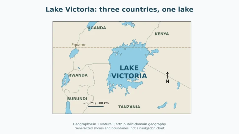
The country reaches far beyond the better-watered highlands. Much of the north and east is arid or semi-arid. In the west, Lake Victoria connects Kenya with Uganda and Tanzania; in the northwest, Lake Turkana extends across the Ethiopian border. Neither lake should be understood as a water body wholly enclosed by Kenya.
The map is a national overview rather than a legal boundary document. Its generalized northern outline does not represent the administrative or control limits of the Ilemi Triangle, an area disputed with South Sudan and administered by Kenya. No maritime claims or lake boundaries are drawn.
2. Country facts and Nairobi
| Item | Detail |
|---|---|
| Capital | Nairobi |
| Population | 54,227,015 in the KNBS 2026 population projection, based on the 2019 census. |
| Published total area | About 224,961 sq mi (582,646 km²), including water, in KNBS Facts & Figures 2026. |
| Government | Republic with a president serving as head of state and head of government; devolved county governments. |
| Languages | Kiswahili is the national language; Kiswahili and English are official languages of the Republic. |
| Currency | Kenya shilling |
| County structure | 47 counties under the Constitution. |
Population is a projection, not a new census count. The area figure is the published KNBS total, not dry land alone or a newly measured 2026 outline. Square miles are rounded.
The population projection carries forward the 2019 census base using demographic assumptions. Its reference year is useful for describing the expected population in 2026, but it does not have the same meaning as a count of people enumerated during a census.
The area table in the 2026 statistical booklet includes 11,230 km² of water within its national total. That accounting is different from the area of a small map silhouette, which depends on boundary conventions, shoreline detail and which water surfaces are represented. It is also different from Kenya’s maritime jurisdiction.
Nairobi’s role as capital does not make Nairobi County, a built-up urban area and the wider metropolitan region interchangeable statistical units. The Nairobi geography profile examines the capital’s setting more closely.
3. Highlands, Rift Valley, drylands and coast
Four settings, with transitions between them
| Setting | Terrain and conditions | Why it matters |
|---|---|---|
| Central and western highlands | Elevated country, mountain slopes and relatively well-watered areas. | Supports contrasting temperature zones, farming landscapes and major inland settlements. |
| Rift Valley | Faulted terrain with escarpments, valley floors, volcanic landscapes and lakes. | Creates sharp local relief and helps explain geothermal resources and enclosed drainage. |
| Northern and eastern drylands | Extensive arid and semi-arid landscapes, with strong rainfall variability. | Water availability and the timing of rain are central geographic constraints. |
| Indian Ocean coast | Low coastal country connected to a warm ocean, with humid maritime conditions. | Supports coastal settlements and the international port at Mombasa. |
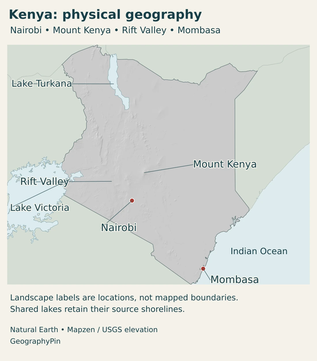
These are broad physical settings, not four administrative provinces. A highland edge can descend sharply into a warmer valley, and rainfall can change across a mountain range. The transition between wetter uplands and dry country is not a single neat line.
Mount Kenya rises to about 17,057 ft (5,199 m). This ancient extinct volcano illustrates how greatly elevation can change within an equatorial country. Its forested slopes and high mountain environments differ from the lower, drier landscapes around them. A national map can locate the massif, but it cannot show every slope or vegetation belt.
The Rift Valley is part of the wider East African continental rift system. Extension of the crust produces faulting and is associated with volcanic activity, although those processes vary through space and time. The rift is not one open crack, nor does its existence mean the continent is about to separate in a single event.
Escarpments, volcanic uplands and low basins influence where roads, farms and settlements can develop. They also affect water movement. Some basins have outlets to larger river systems, while others retain water internally and lose it mainly through evaporation.
4. Climate and three contrasting water routes
Why are the highlands different from the coast?
Elevation is a major part of the answer. Air temperatures generally decrease with height, so elevated Nairobi and the mountain country can be much cooler than the coast or low northern basins. Being close to the equator does not cancel this effect.
Moisture is equally important. Seasonal circulation brings changing winds and rainfall, while mountains influence where air rises and rain falls. Kenya’s central and western highlands include relatively humid areas; much of the north and east is dry. The coast has its own maritime influence rather than simply sharing the climate of inland places at a similar latitude.
The familiar seasonal pattern includes the March–May long rains and October–December short rains. It is not an exact calendar for every locality. The Kenya Meteorological Department also identifies June–August rainfall in the coastal region, the highlands west of the Rift Valley and the Lake Victoria basin.
These are climatic patterns, not a forecast for a particular trip or growing season. Rainfall varies between years, and both drought and flooding can occur. A wet highland district and an arid northern district therefore need different expectations about water availability, even within the same national season.
Lake Victoria, the Tana and Turkana do not drain alike
Lake Victoria is shared by Kenya, Uganda and Tanzania. Its wider catchment extends beyond those three countries, and it belongs to the upper Nile system. The lake itself and its basin are different geographic objects: one is a water surface, the other the surrounding area that contributes drainage.
The Tana offers a different route. Rising in the Mount Kenya setting, it flows east toward Garissa and then south to the Indian Ocean at the Tana Delta. Its upper basin includes steep mountain slopes, while much of the middle and lower basin is flatter. Water connects these contrasting landscapes along the river.
Lake Turkana is different again. It lies in a closed basin with no surface outlet to the sea. The Omo, flowing from Ethiopia, is a major source of inflow. The lake therefore depends on processes across an international catchment, even though most of its visible extent lies in Kenya.
These examples explain why “Kenya’s water” cannot be reduced to one national river basin. Western drainage connects with the Nile, the Tana reaches the Indian Ocean, and Turkana retains water within an internal basin. Lake levels and shorelines also change, so the map’s generalized water outlines are not a current water-level survey.
5. Cities, counties and languages
Nairobi’s inland location places the capital in the highland transport network rather than on the ocean. Mombasa connects that interior with maritime routes. Kisumu offers a western lake setting. Their contrasting positions help explain urban roles without treating every important Kenyan city as a version of the capital.
The Constitution divides Kenya into 47 counties and establishes national and county levels of government. Physical regions such as the Rift Valley and the highlands do not replace these counties. A river basin can cross county boundaries, while one county may include more than one kind of terrain.
The relationship between terrain and settlement is also visible outside the largest cities. Wetter highland landscapes offer different farming conditions from the dry north and east. Water access, transport and the suitability of land for different livelihoods matter alongside the simple amount of land available.
National and official language roles
Kiswahili has national-language status. Kiswahili and English are the official languages of the Republic. These constitutional roles do not imply that Kenya has only two spoken languages: the Constitution also provides for the promotion and protection of Indigenous languages and linguistic diversity.
Kenyan Sign Language has an explicitly recognized role in Parliament alongside Kiswahili and English. That parliamentary provision is distinct from the Republic-wide official-language wording. Keeping the two levels clear avoids turning a specific legal provision into a different national-language claim.
6. Geography in farming, energy and trade
Kenya’s Constitution makes the president both head of state and head of government. County devolution adds a second level of public administration, but national landscapes and economic connections routinely cross those administrative boundaries.
Tea provides a concrete highland example. The central mountain country and western areas such as the Kericho and Nandi highlands are important tea-growing settings. Temperature, rainfall and elevation help explain that concentration. “Equatorial agriculture” is too broad a label to explain why tea grows in these uplands rather than uniformly across the country.
The Rift Valley contributes another connection between physical geography and production. At Olkaria, geothermal development uses the heat resources associated with the rift’s geological setting. This is an energy use of a particular landscape, not evidence that all volcanic terrain can support an identical power project.
Mombasa illustrates the value of the coastline. Its port serves Kenya and a wider East and Central African hinterland. Cargo movement depends on the relationship between shipping, port facilities and inland transport, so the port’s economic geography extends well beyond the city itself.
Together, highland farming, geothermal energy and maritime trade show why Kenya’s geography is more than a backdrop for wildlife tourism. Elevation affects climate and crops; geology creates energy opportunities; and a coastal gateway links inland communities with overseas markets.
Frequently Asked Questions
Why is Nairobi cooler than Kenya’s coast?
Nairobi is in elevated inland country. Higher elevation generally brings lower temperatures, while the coast has low elevation and a maritime influence. Kenya’s equatorial latitude does not make temperatures identical everywhere.
Is Lake Victoria entirely in Kenya?
No. The lake is shared by Kenya, Uganda and Tanzania. Its drainage basin extends farther than the lake’s shores and is connected to the Nile system.
Does Lake Turkana drain into the Nile?
No. Lake Turkana occupies a closed basin with no surface outlet to the sea. Lake Victoria, by contrast, is connected to the Nile system. The two lakes belong to different drainage settings.
What Did We Learn Today?
Kenya combines equatorial latitude with strong contrasts in altitude, rainfall and drainage. Highlands, Rift Valley basins, dry northern and eastern country, and an Indian Ocean coast support different environments and economic connections. Nairobi is the capital, while Mombasa and Kisumu illustrate coastal and lake settings. Dated projections, clearly scoped area figures and the distinction between a lake and its basin make country facts easier to interpret.
Sources & Data Notes
Population and area follow the specified KNBS publications, rather than an undated live count or map-derived measurement. Sources were checked for this profile in November 2026.
- KNBS, population projections: 2019 census-based projection report, Table C: 2026 all-age population. This is a projection, not an enumeration.
- KNBS, Facts & Figures 2026: Published country facts and total area, including the booklet’s water category. No new survey date is inferred.
- Constitution of Kenya: Articles 6–7, 120 and 131 and the First Schedule: counties, languages, Parliament and presidential roles.
- Nairobi City County Assembly: Capital location and inland transport setting.
- Kenya Meteorological Department, State of the Climate 2022: Introduction: regional climate and seasonal rainfall patterns; the report’s 2022 weather observations are not a current forecast.
- UNESCO, Mount Kenya: Mountain height, extinct volcanic origin and contrasting mountain environments.
- USGS, East African Rift: Continental extension, faulting and volcanism; not a forecast of an imminent continental split.
- Water Resources Authority, Lake Victoria South Basin: Shared lake and wider upper-Nile basin context.
- Water Resources Authority, Tana Basin: River course, upper mountainous catchment and Indian Ocean outlet.
- USGS Earthshots, Lake Turkana: Closed-basin drainage and cross-border inflow. Historical imagery does not establish today’s lake shoreline.
- UNIDO, Kenyan tea industry report: 2017 report, geographic tea-growing settings and climatic influences.
- KenGen, Olkaria project: Geothermal development in the Rift Valley setting.
- Government Advertising Agency, Mombasa port: Regional port and hinterland connections.
- PCGN, Kenya factfile 2026: Geographic naming and Ilemi Triangle administration and boundary context.
Map sources and scope: Original GeographyPin maps use public-domain Natural Earth country outlines, lakes and city coordinate attributes. Lake Victoria and Lake Turkana are shown across national borders; no international lake boundary or maritime delimitation is inferred. Generalized lake outlines are not a current water-level survey.
Landscape labels mark broad locations, not measured regional boundaries. The Mount Kenya marker identifies the massif rather than an exact summit coordinate, and the Rift Valley label is not a surveyed rift axis. The generalized national outline does not portray the administrative or control limits of the Ilemi Triangle, which is disputed with South Sudan and administered by Kenya; no disputed polygon has been invented.
Physical-map hillshade is calculated from real elevation data accessed through Mapzen Terrain Tiles. Global elevation data courtesy of the U.S. Geological Survey. Elevation-source attribution and terms apply. Shading indicates terrain form, not numerical elevation classes or navigation detail.
The cover uses Kenyan flag artwork in a country-outline motif, alongside an intact flag, divider and GeographyPin branding.