Grand Teton’s scenic loop goes up one side of Jackson Hole and back down the other. Take the outer highway for a wider view of the peaks across the valley, or Teton Park Road to get close to Jenny Lake. The two join north of the lake, but the full driving loop depends on the season.
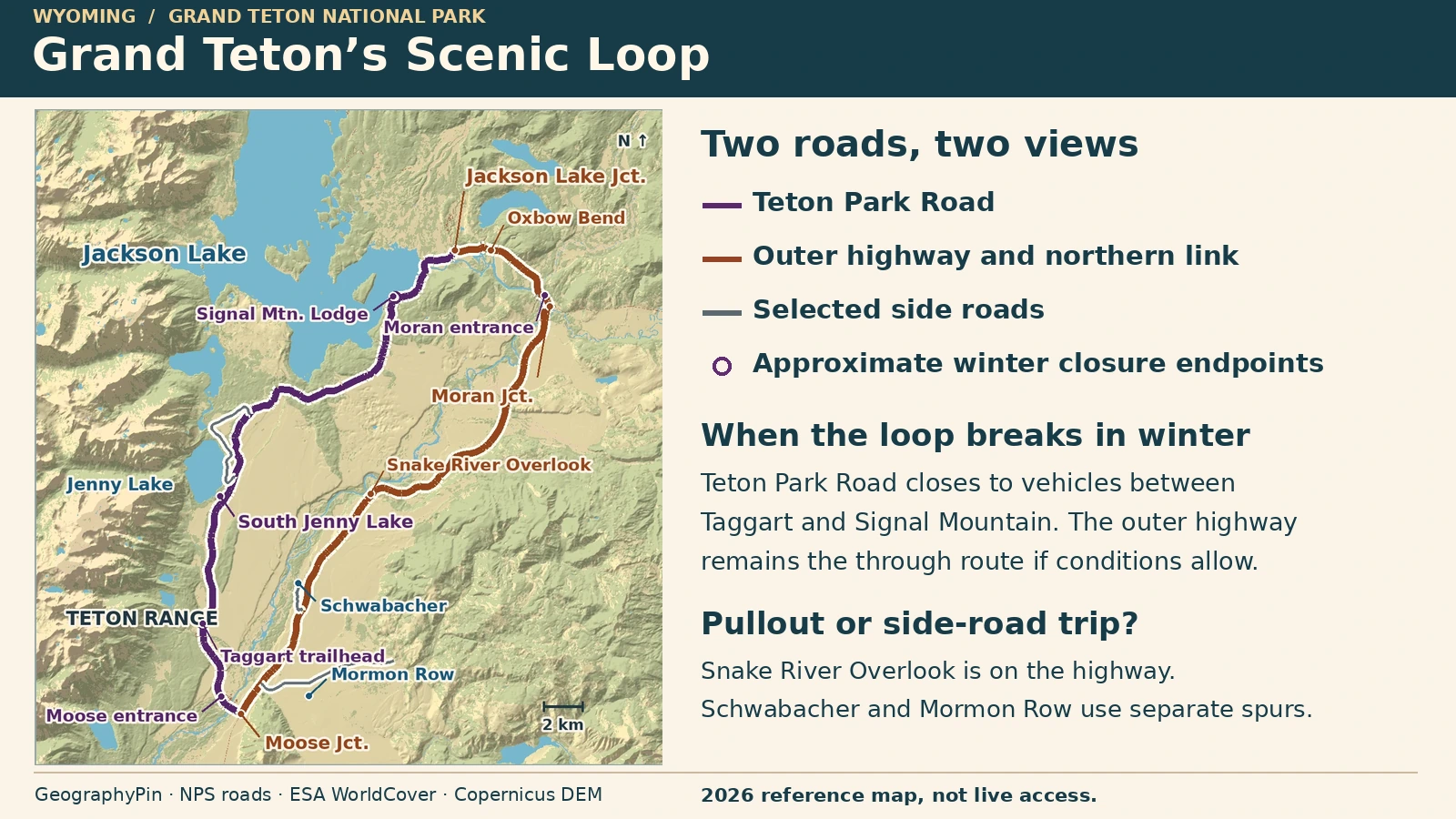
US 26/89/191 carries the widest views of the Teton front across the valley. Teton Park Road gets closer to the peaks and Jenny Lake. Join them via Jackson Lake Junction and Moran Junction when all three legs are open; the inner road’s winter closure breaks the driving loop.
Choose the kind of stop you want: Start with the route map, compare the highway overlooks and side roads or check the seasonal gates before driving.
Choose the highway for the wide view, the inside road for lakes
The east side of the valley puts more space between you and the Tetons. From roadside turnouts on US 26/89/191, you see the mountains across open flats or above the bends of the Snake River. Teton Park Road runs closer to the mountain front. Its reward is not the same sweeping view at every curve, but access to the Jenny lakeshore and viewpoints closer to the slopes.
| If you want… | Start with… | What could change the plan |
|---|---|---|
| A broad Teton view with little walking | Outer highway turnouts, particularly Snake River Overlook | Check highway conditions and whether the pullout itself is clear. A spur to Mormon Row or Schwabacher is a separate decision. |
| A lakeshore stop and time out of the car | Enter at Moose for South Jenny Lake, or reach the north end through Moran | Check Teton Park Road and parking; do not assume the seasonal road or a separate scenic spur is open. |
The loop starts at Moose Junction, where the access road leaves the outer highway for the Moose Entrance Station. On the return, Jackson Lake Junction is where Teton Park Road meets the northern connector. That road runs east past Oxbow Bend and the Moran Entrance Station to Moran Junction. At Moran Junction, turn south on the shared US 26/89/191 highway to reach Moose Junction again.
The National Park Service lists Teton Park Road as 20 miles (32 kilometers). The three mapped road legs together are roughly 43 miles (69 kilometers), excluding the approach from Jackson and every turnout, side road or walk. The park concessioner uses the name “42 Mile Scenic Loop Drive” for the same basic outing. We measured about 42.5 miles (68.4 km) along the mapped centerlines between Moose, Moran and Jackson Lake junctions, which rounds to 43 miles. Neither figure tells you how long the drive will take. If you approach from the southwest, the Moose–Wilson Road is a separate access road and is not needed to complete this loop.
What you can reach from Teton Park Road
From Moose, take Teton Park Road north toward South Jenny Lake. It is the better stop if you want to park and see the lake on foot rather than spend the visit looking through a windshield. For a short paved lakeshore stop, follow posted directions to the Outlet Overlook near the visitor area. For a longer hike, use the trail descriptions and current condition report rather than treating the loop mileage as a walking distance. Parking can fill in summer.
Jenny Lake Scenic Drive is the separate paved spur that leaves at North Jenny Lake Junction and rejoins Teton Park Road just north of South Jenny Lake. Its lakeside section is one-way south for vehicles. The Park Service describes the drive as about three miles. It is not the Jenny Lake hiking loop, and you cannot turn north up the one-way section from the south junction.
Continue north toward Signal Mountain and Jackson Lake Junction for the connection back toward Moran. Signal Mountain Lodge is a useful landmark for the seasonal road closure. It is not the same stop as the separate summit road or overlook. If your plan needs only a lakeshore stop, you do not have to drive the whole loop; return by the same approach if the road and parking are open.
Mormon Row takes a side road off the highway
Antelope Flats Road leaves US 26/89/191 north of Moose Junction. Use it to reach Mormon Row, not as the through road connecting the two sides of the valley. The historic district has barns on both sides of Antelope Flats Road. The T.A. Moulton Barn is south of the road; John Moulton’s homestead is north of it. Access from parking may be on uneven dirt surfaces or on temporary routes while work is under way.
Mormon Row gives a different foreground from the highway overlooks: buildings, open ground and the mountain range behind them. If the spur or parking is closed, the highway may still be usable. Do not treat the road shoulder as a substitute for designated parking or assume that the old approach is open to pedestrians.
Where to stop for the wider mountain view
Snake River Overlook is a paved highway pullout with a short paved approach from parking. It puts the river below you and the peaks beyond it. Glacier View Turnout is another quick highway stop. Use marked pullouts rather than stopping in a lane for a photograph, and skip a stop if you cannot enter its parking area safely.
Schwabacher Landing is lower and closer to the water. It is not a paved turnout on the highway: the Park Service documents about 1.1 miles of gravel access road before parking, plus an unpaved walk to some viewpoints. The 1.1 miles describe driving, not walking. The gravel approach is seasonal and a poor substitute if you specifically need a paved roadside stop.
Oxbow Bend is on the northern connector between Moran and Jackson Lake Junction, not on the east-side highway south of Moran. It is useful if you are heading through Moran and want a river foreground farther north. If you stop only on the highway between Moose and Moran, Oxbow Bend is a detour, not a pullout you will pass automatically.
When the full loop does not work
Grand Teton’s usual winter closure to motor vehicles is November 1 through April 30 between Taggart Lake Trailhead and Signal Mountain Lodge. The park’s usual open season for through driving is May through October, but weather or work can interrupt access. The outer highway is normally maintained in winter; ice, storms or construction can still affect it. The Antelope Flats and Schwabacher spurs have their own weather-dependent closures. An open highway does not mean those branches are open.
When the inner section is closed, use the highway as an out-and-back for any open east-side turnouts. For an open stop north of the winter closure, approach via Moran and Jackson Lake Junction rather than assuming you can drive through from Moose. If a gate on your intended branch is closed, turn back to the open highway instead of looking for a shortcut on a different park road. The winter closure can allow non-motorized use, but snow and grooming conditions determine what works on that day.
Access checked November 21, 2026. The NPS announced the normal seasonal closure and listed construction impacts around Moran, Taggart and Mormon Row. Its November 4 construction update says Taggart trails may be used in winter when conditions allow, with the main Taggart trailhead and trails scheduled to close again May 1, 2027 for work. Those project notes do not guarantee an open trail, side road or parking lot on your date. The WYDOT report visible during this check last marked Moose to Moran Junction slick on November 20.
Before leaving, read the park road status for gates and spurs, and Wyoming 511 for the highway. Check the National Weather Service point forecast near Moran separately. A forecast describes weather; it does not tell you whether a gate is unlocked or a pullout has been cleared.
Frequently Asked Questions
Do I need a timed-entry reservation or a park pass?
As checked November 21, 2026, the park did not require timed entry. It still requires an entrance pass where applicable. The NPS lists cashless payments, a standard seven-day private-vehicle fee of $35 and a separate nonresident policy; check the official current fee page for eligibility and exceptions.
Can I use the boat at Jenny Lake as part of the drive?
No. It is a separate lake service, subject to its own season and conditions. The road loop does not require a boat ticket, and the boat is not a shortcut for vehicles.
Are Jackson Lake Junction and Moran Junction the same turn?
No. Jackson Lake Junction is where Teton Park Road meets the northern road. Moran Junction is farther east, where that northern road meets the highway back toward Moose. Oxbow Bend is between them.
Can I use the same loop to enter Yellowstone in winter?
Do not plan a winter through-drive into Yellowstone from here. Yellowstone’s South Entrance is normally closed to ordinary wheeled vehicles in winter. Check Yellowstone’s separate road status even if the highway north of Moran is open.
What Did We Learn Today?
The outer highway puts the Tetons across the valley for a wider view. Teton Park Road runs near the peaks and reaches Jenny Lake. The connector past Oxbow Bend joins the two, but winter closes the inner section to cars. Check each side road separately rather than treating the whole loop as open or closed together.
Sources & Data Notes
- NPS, Teton Park Road and its 20-mile length; NPS, Outer Park Road; NPS park road reference map; NPS driving tour reference; Grand Teton Lodge Company’s scenic driving itinerary. The roughly 43-mile loop is an editorial estimate from current NPS centerline geometry between the named junctions, excluding diversions and the approach from Jackson.
- NPS, Jenny Lake, Jenny Lake one-way scenic drive, Outlet Overlook, Mormon Row and Snake River Overlook. NPS Snake River Headwaters plan documents the 1.1-mile Schwabacher gravel approach; NPS landing access information distinguishes the walk from parking.
- Seasonal access and status reviewed November 21, 2026: NPS park roads, park alerts, NPS road construction, NPS temporary trail and district access, WYDOT US 191 road reports, and NWS forecast near Moran. Road and weather status are separate; the article is not a live alert.
- NPS fees and nonresident policy, cashless fee FAQ, Grand Teton reservations and Yellowstone road status.
- Map: GeographyPin. Road centerlines from NPS Public Roads, checked November 2026. Background water uses ESA WorldCover 2021 v200 (CC BY 4.0); © ESA WorldCover project 2021 / Contains modified Copernicus Sentinel data (2021) processed by ESA WorldCover consortium. Relief produced using Copernicus WorldDEM-30 © DLR e.V. 2010-2014 and © Airbus Defence and Space GmbH 2014-2018 provided under COPERNICUS by the European Union and ESA; all rights reserved.
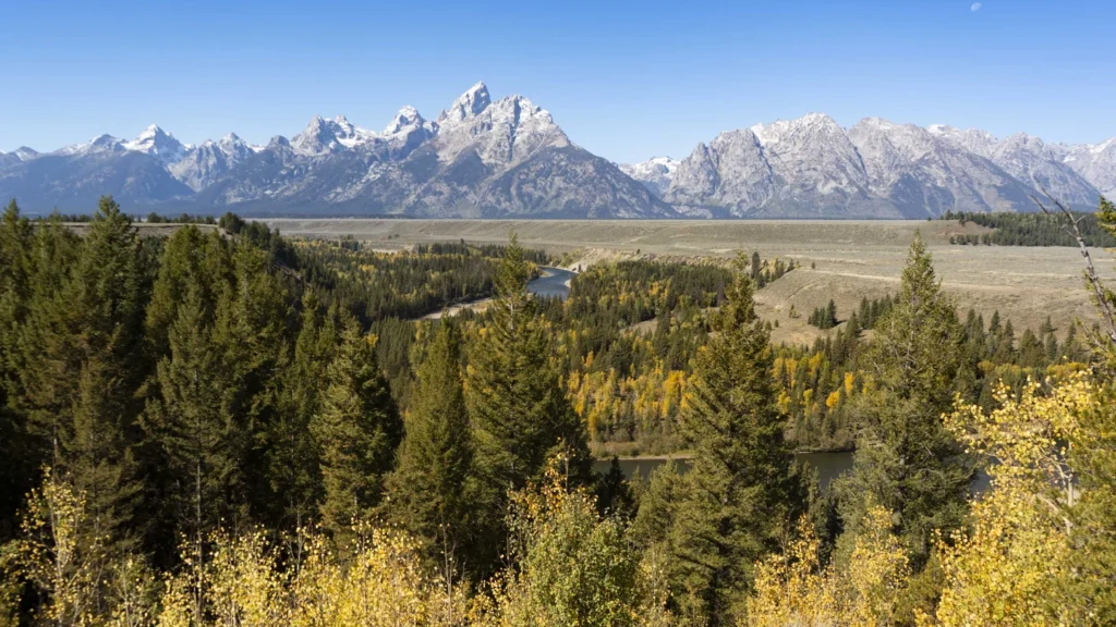
- Featured photograph: Snake River Overlook, NPS Photo/M. Nall, September 22, 2024, U.S. public domain; cropped, resized and converted to WebP. The photograph illustrates the view, not current visibility or conditions.