Gorée Island, Senegal, lies just offshore from Dakar, separated from the capital by Atlantic water. Its small size makes it easy to overlook on a regional map, while its prominence as a place of memory can obscure the difference between an island, a settlement and a protected cultural site.
Where is Gorée Island?
Gorée is a Senegalese island off Dakar, off the southeastern coast of the Cap-Vert Peninsula. It is separated from the mainland by water and reached by a maritime connection. Its historic settlement is a UNESCO World Heritage site, but heritage recognition is not a separate jurisdiction or a substitute for a shoreline map.
How to use this article: separate the names, understand the crossing, distinguish memory from measurement, read the map’s scope.
Finding Gorée beside Dakar
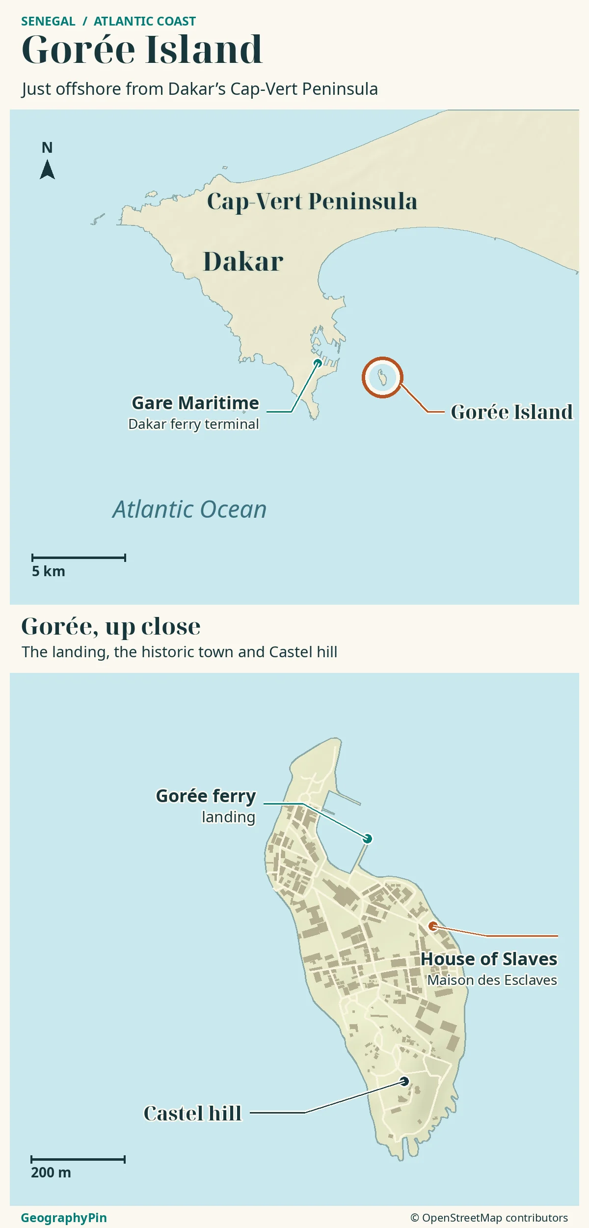
Gorée is a small Atlantic island beside Senegal’s capital, not a distant offshore archipelago. On a map of West Africa, first find Dakar on the projecting Cap-Vert Peninsula. Then look just offshore to its east-southeast for Gorée. At that scale the island may appear only as a dot, so a second, closer map is needed to understand its shoreline and settlement.
Three names to keep separate
| Name | What it identifies | What it does not mean |
|---|---|---|
| Gorée Island | The island and its inhabited settlement off Dakar. | A neighborhood joined to the mainland by a road. |
| Cap-Vert Peninsula | The Senegalese mainland peninsula on which Dakar stands. | The independent island country of Cabo Verde. |
| Island of Gorée World Heritage property | The cultural site inscribed by UNESCO in 1978. | A separate sovereign territory or a nautical chart. |
The harbour crossing from Dakar
Water separates Gorée from Dakar. That is a small distance on a regional map but a meaningful transport barrier: reaching the waterfront is not the same as reaching the island. The mainland port and the island landing belong to opposite ends of a sea crossing.
The Liaison Maritime Dakar–Gorée advertises departures from the Gare Maritime de Dakar. For an actual visit, identify that passenger terminal rather than using a generic pin for the Port of Dakar, which covers a much larger working harbour. A museum location on Gorée is not a boarding location in Dakar.
A crossing is not a walking connection
Check the operator for the departure you intend to use, boarding arrangements and the return sailing. A line joining the two shores on a tourist map should not be read as an exact navigational track or a guaranteed operating service. The island’s proximity does not remove the need to plan the water crossing.
Allow time for the journey to the terminal and boarding rather than treating a quoted time on the water as the entire door-to-door trip. Ferry access and admission to an individual museum are separate arrangements.
Gorée and the Cap-Vert Peninsula
The peninsula is the larger mainland feature; Gorée is one of the small islands off its coast. The two are easy to confuse on an oversimplified map that enlarges Gorée without explaining the change of scale. A useful inset magnifies the island while leaving its actual position clear in the regional panel.
Gorée is not at the far western end of the peninsula. Its position is beside Dakar’s southeastern coastal sector, on the harbour side of the wider landform. “Off Dakar” is therefore more informative than simply calling it an island at Africa’s western tip.
Its relief also deserves more than a flat island symbol. UNESCO identifies the Castel as a rocky plateau bearing fortifications above the settlement. That elevated feature and the coastal landing occupy different parts of the island. A boat arrival does not place a visitor at every historic site.
The name Cap-Vert is sometimes translated as Cape Verde. In this setting it refers to Senegal’s mainland peninsula. It should not be used to place Gorée in the Republic of Cabo Verde, which is a separate Atlantic island country.
A historic settlement and a place of memory
Gorée’s World Heritage recognition concerns a historic settlement and its association with the Atlantic slave trade. Streets, buildings, fortifications and places of remembrance form a wider setting; the island is not simply one museum surrounded by water.
Memory and historical measurement
The Maison des Esclaves, or House of Slaves, presents itself as a place of remembrance and transmission. Its “Door of No Return” has a powerful commemorative role. That symbolic importance should be distinguished from a claim that a particular number of people passed through that exact doorway.
Historical interpretation of the house and the scale of Gorée’s role in the trade have been debated. Historian Cheikh Sene’s 2022 study examines the relationship between scholarship, public memory and emotion at the site. Neither an unsupported total nor a sweeping dismissal of the island’s history helps explain what the place represents.
The island’s importance as a place of remembrance does not depend on proving a particular traffic total for one building. Its streets, houses and fortifications provide a broader setting in which to consider slavery, colonial power and their legacies.
Gorée remains an inhabited place. The commune’s current website includes civic services and school activities alongside heritage news. Read its buildings and streets as part of a living community, not as a vacant display whose only purpose is tourism.
The island, the commune and the heritage site
Can a heritage map stand in for an island map?
Only for the information it actually shows. A World Heritage map concerns a designated property; a shoreline map describes the edge of land; a municipal boundary concerns administration. Even when they cover broadly the same place, they answer different questions.
The regional map locates Gorée beside Dakar; the enlarged island map shows the landing, settlement and Castel hill. These are physical features rather than a delineation of the UNESCO property. A locator point identifies a place, not the extent of a protected area.
Use the shoreline and landmarks to understand how the island fits together. Heritage rules and administrative boundaries require their own official documentation; they cannot be inferred from the visible coast alone.
A dated shoreline and a newer general-purpose map can differ because their scale, source imagery or treatment of piers and seawalls differs. Such a mismatch alone does not prove erosion, land reclamation or a change of jurisdiction. Those conclusions require dated evidence of the relevant change.
Gorée is part of Senegal and has a municipal administration. UNESCO recognition does not transfer sovereignty or make the island an international enclave. The surrounding sea separates it physically from Dakar without separating it from Senegal.
Frequently Asked Questions
Are Gorée and Goree different places?
No. Goree is the common unaccented spelling of Gorée. Adding Senegal or Dakar helps distinguish the island from unrelated places and businesses using a similar name.
Why do maps give different distances from Dakar?
They may measure from different points: the nearest mainland shore, the passenger terminal or a city-center marker. A straight-line separation is also different from the distance sailed. Compare endpoints and measurement methods before comparing the figures.
What Did We Learn Today?
Gorée is an inhabited Senegalese island beside Dakar, not part of Cabo Verde or a mainland neighborhood. Its water crossing, shoreline, municipal life and heritage recognition are connected but distinct. Reading them separately makes both the atlas and the island’s historical significance easier to understand without inventing boundaries or repeating unsupported historical totals.
Sources & Data Notes
- UNESCO World Heritage Centre: Island of Gorée
- UNESCO geographical data and maps
- Commune of Gorée: civic and heritage information
- Liaison Maritime Dakar–Gorée: departure terminal information
- Maison des Esclaves: its memorial interpretation
- Cheikh Sene, African Studies Review, 2022: history, memory and emotion
Sources checked November 19, 2026. No exact island area, historical deportation total or live ferry schedule is asserted. The map is for geographical orientation, not navigation or a legal boundary survey. Museum interpretation and historical analysis are distinguished rather than treated as interchangeable kinds of evidence.
Map: GeographyPin original atlas using OpenStreetMap coastlines dated November 18, 2026 and the island outline, Dakar terminal, Gorée landing and House of Slaves checked November 19. © OpenStreetMap contributors, ODbL. Relief: Mapzen/AWS Terrain Tiles and its underlying elevation sources. No ferry track, walking itinerary or legal heritage boundary is drawn; the regional ring is a locator, not a buffer.
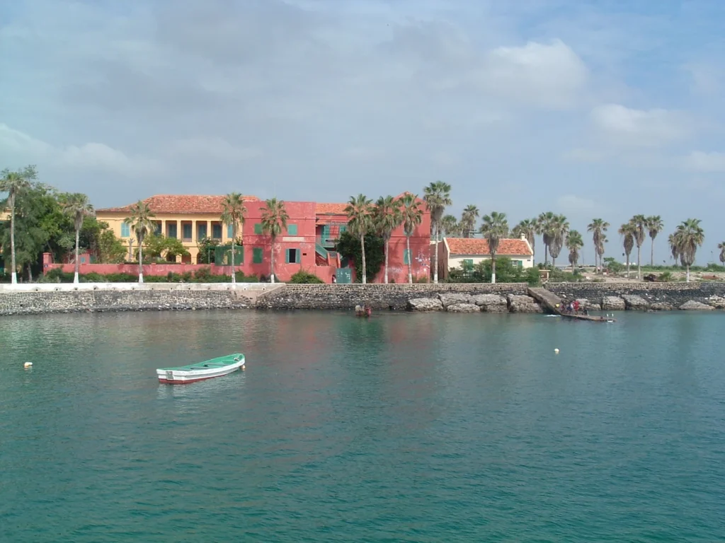
Photograph: Gorée waterfront, Initsogan / Wikimedia Commons, CC BY-SA 3.0. Resized and converted to WebP.