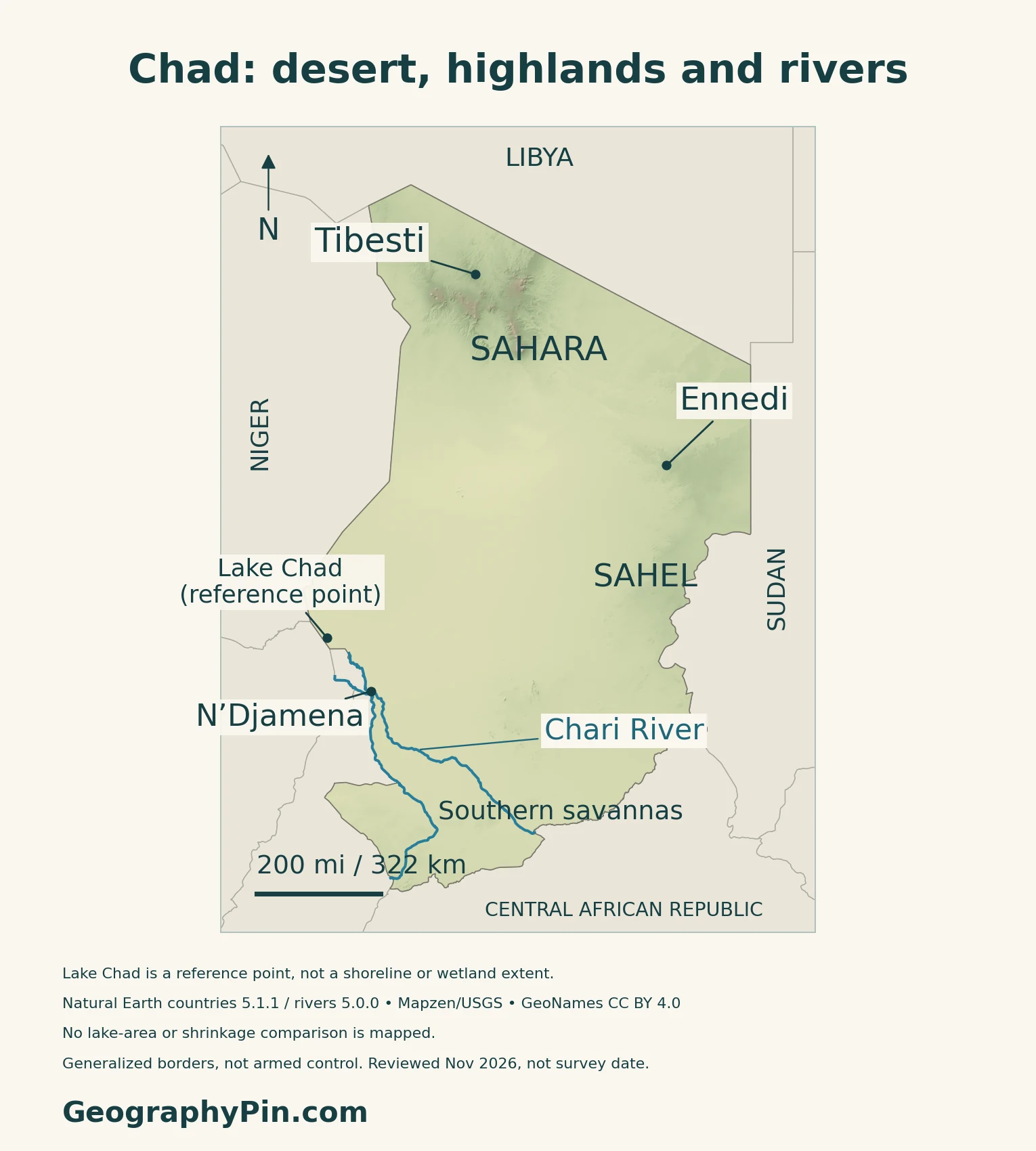
Chad spans a striking north-to-south transition: Saharan mountains and desert, the seasonally dry Sahel, and wetter southern savannas. Lake Chad occupies only one part of that geography. Its river-fed waters, the northern Tibesti and Ennedi uplands, and the capital’s southwestern position all help explain a country that is neither uniformly sandy nor uniformly dry.
Chad is a landlocked country in north-central Africa, with N’Djamena as its capital. The Sahara dominates the north, the Sahel forms a central transition belt, and wetter savannas occupy the south. The Chari–Logone river system feeds Lake Chad in the southwest. The lake’s changing waters must be distinguished from its much larger drainage basin.
How to use this article: Locate the country on the map, read the physical map, explore lake measurements, or check the population reference.
1. Locate Chad and Its Southwestern Capital
Six neighbors around a landlocked state
Chad lies in the interior of Africa, with Libya to the north, Sudan to the east and the Central African Republic to the south. Cameroon, Nigeria and Niger complete its six-country neighborhood on the western side. It has no ocean coast.
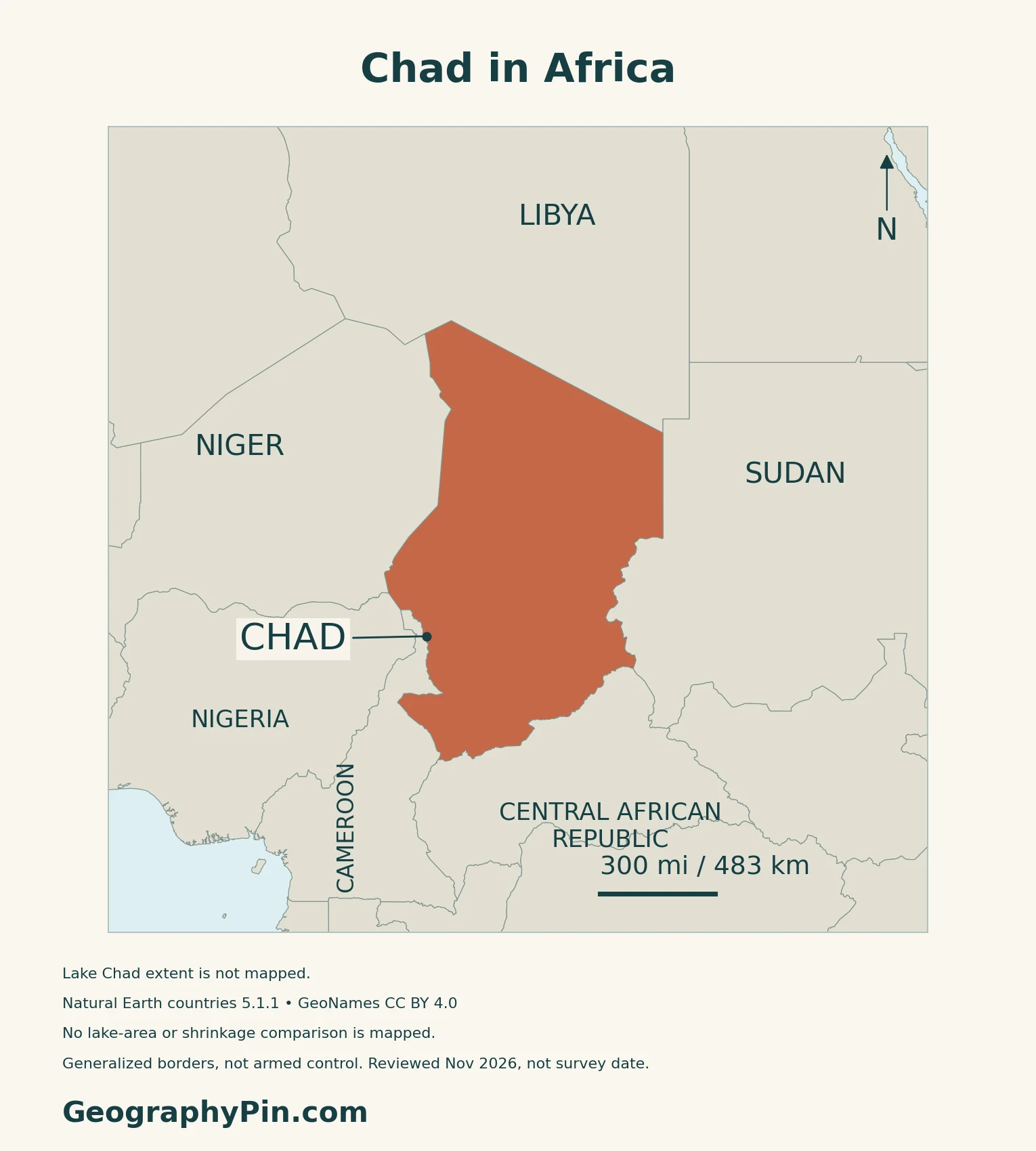
N’Djamena is the capital and government seat
N’Djamena is both the national capital and the location of the central government. Chad is one country within the wider Central African region. The neighboring Central African Republic is a separate state, not another name for that region.
2. Sahara, Sahel and Northern Highlands
Three broad zones, not three sharp boundaries
| Broad zone | Position | General character |
|---|---|---|
| Saharan | North | Arid desert, including major uplands |
| Sahelian | Central belt | Semi-arid transition with a shorter rainy season |
| Sudanian savanna | South | Wetter seasonal landscapes and more vegetation |
Chad’s National Adaptation Plan distinguishes these broad environmental zones, with finer subdivisions within them. They are not provinces.
Tibesti and Ennedi have different rock landscapes
The Tibesti in northern Chad includes volcanic mountains. At its southeastern end, Emi Koussi is a broad shield volcano. NASA gives its summit as about 11,200 feet (3,415 m), the highest in the Sahara. That sourced summit height is not a measurement taken from our shaded terrain map.
The Ennedi Massif farther east is a sandstone plateau sculpted into canyons, cliffs and natural arches. UNESCO’s mixed natural-and-cultural World Heritage designation also recognizes its extensive rock art. Water retained in some large canyons supports life within an otherwise arid setting.
Ounianga shows why desert does not mean waterless
The Lakes of Ounianga form a separate World Heritage property in northern Chad. UNESCO describes 18 lakes sustained by groundwater, including fresh, saline and highly saline waters. Dunes, reeds and underground connections help create contrasting lake conditions.
They are not northern arms of Lake Chad. Their presence illustrates the difference between scarce local rainfall and water supplied or stored below ground.
3. Rainfall, the Chari River and a Changing Lake
Why the south is wetter than the north
The seasonal movement of the tropical rain belt brings a longer wet season to southern Chad and a shorter one to the central Sahel. Northern desert areas receive very little rain. UNDP’s climate profile links year-to-year rainfall variability to changes in this seasonal circulation.
The contrast is not simply “hot north, cool south.” Rainfall amount and season length are the clearer organizing differences, while elevation modifies local conditions.
Lake Chad receives water from beyond Chad
The Chari and Logone collect water from catchments extending into the Central African Republic and Cameroon. The Lake Chad Basin Commission distinguishes these connected sub-basins from the lake itself. Rainfall far upstream therefore matters to conditions downstream.
The Central African Republic profile explains the southern headwater setting. Here, the lake is a reference point, not a drawn current shoreline or a measurement of flooded land.
Why one shrinkage percentage is misleading
A 2020 satellite study examined Lake Chad over 2001–2018. It found a relatively stable southern pool and much greater variability in the northern pool, including dry periods and later partial recovery. These findings describe that observation period, not the lake’s exact extent today.
The researchers also showed why published lake-area figures can differ: some measure only open water, while others include water beneath vegetation. Seasonal timing and the choice of northern pool, southern pool or whole lake change the comparison too. Any claim about expansion or contraction needs the dates, area definition and measurement method together.
4. Farming, Mobility and Routes to the Sea
Water availability shapes farming and livestock needs
The National Adaptation Plan describes agriculture as largely rain-fed and highly dependent on the rainfall regime. It also treats livestock, fisheries and water resources as linked adaptation concerns. A delayed rainy season, unreliable water point or damaged access route can affect livelihoods in different ways.
Cameroon provides an important Atlantic gateway
The World Bank’s 2023 Country Economic Memorandum identifies the Douala–N’Djamena corridor as a major trade connection. Chad has no seaport of its own, so road links and transit arrangements through neighboring countries matter alongside domestic transport.
The same assessment describes an uneven road network and limited all-season feeder-road access. Farms can be connected to a national highway in principle yet still face difficulty reaching markets locally. These are infrastructure relationships, not a claim that every route has the same condition today.
Oil exports and everyday livelihoods are different measures
The World Bank identifies oil as a major driver of Chad’s economic growth and public revenue, while agriculture remains important for employment. An export profile dominated by petroleum does not describe the work or income of every household.
5. Dated Country Facts and Census Status
| Item | Reference | Date or scope |
|---|---|---|
| Capital and government seat | N’Djamena | National capital; central government located here |
| Population | About 21.004 million | UN 2025 medium-fertility projection |
| Surface area | About 495,755 sq mi (1,284,000 km²) | UN reference, 2023; surface area, not a land-only figure |
| Official languages | French and Arabic | Constitution, Article 10 |
| Currency | Central African CFA franc (XAF) | BEAC-issued currency |
| Government | Republic; unitary state | 2023 Constitution, revised in October 2025 |
The 2026 census is a different statistical product
The population figure in the table is a UN projection for 2025, not a count from Chad’s 2026 census. INSEED reports that the main RGPH-3 enumeration ran from 20 June to 6 August 2026. Its closure announcement noted continued work with specific populations and households missed during the main operation.
On 31 August 2026, INSEED reported that analysts were preparing preliminary results. The verified releases used here do not provide a new national population total. A reported household count is not interchangeable with a count of people.
Official languages and the current constitutional framework
Article 10 names French and Arabic as official languages and provides for the promotion and development of national languages. Official status does not make these the country’s only spoken languages.
The constitutional framework dates from December 2023 and was revised in October 2025. It provides for national institutions and autonomous local authorities within a unitary state. These legal arrangements should not be confused with a map of current security conditions.
Chad uses the BEAC-issued Central African CFA franc, shared with other members of the Central African monetary union.
What Did We Learn Today?
Chad’s geography changes from Saharan uplands and desert through the Sahel to wetter southern savannas. The Chari–Logone system links Lake Chad with upstream countries, while groundwater sustains distinct northern desert lakes. Lake area requires dates and a clear water definition. National population projections, census fieldwork and published census totals are different kinds of evidence.
Sources & Data Notes
Population is labeled by source and reference date; census fieldwork is not itself a published population total. Climate zones are broad environmental descriptions, not administrative boundaries. The 2020 Lake Chad study analyzes 2001–2018 and distinguishes open water from vegetated inundation; it is not a current lake-area estimate. The map locates the lake without drawing a current shoreline. NASA’s published Emi Koussi height is separate from the map’s relief raster. UNESCO material supports landscape and property descriptions, not present visitor access. The World Bank’s 2023 economic memorandum is a dated structural assessment.
- UNData: 2025 projected population and 2023 surface area
- INSEED, 8 August 2026: main census enumeration completed; remaining coverage work
- INSEED, 31 August 2026: preparation of preliminary census results
- Chad Constitution, consolidated October 2025 text: capital, languages and institutions
- UNHCR RiMAP: neighboring states, capital and government seat
- BEAC: Central African CFA franc
- France Diplomatie, updated 30 October 2026: current institutional context
- Chad: first National Adaptation Plan, climatic zones and livelihoods
- UNDP climate profile: seasonal rainfall circulation
- NASA: Emi Koussi and the Tibesti volcanic landscape
- UNESCO: Ennedi Massif natural and cultural landscape
- UNESCO: Lakes of Ounianga
- Lake Chad Basin Commission: Chari and Logone sub-basins
- Pham-Duc and colleagues, 2020: Lake Chad hydrology, 2001–2018 observations
- World Bank, 2023: Chad Country Economic Memorandum
Map method: Original GeographyPin maps use public-domain Natural Earth countries 5.1.1 and rivers 5.0.0. Actual supplied Chari and Logone linework is shown, not a complete drainage network. GeoNames location data are credited under CC BY 4.0. Lake Chad is a reference point from the UK PCGN factfile; no shoreline, lakebed, wetland extent or change comparison is mapped. Relief uses real Mapzen Terrain Tiles with Mapzen/USGS and upstream credits, not measured summit heights. Regional labels do not define climate or vegetation boundaries. WGS84 scales apply at their displayed latitude. Generalized borders are not current armed-control lines; November 2026 is a review date, not a survey date. The cover uses the public-domain Commons Chad flag rendition, including a separate complete flag, for editorial identification.