The Central African Republic is easiest to understand through its rivers. Its interior uplands separate waters flowing toward Lake Chad from waters joining the Congo system. Across the same country, wetter southern forests give way to more seasonal savanna landscapes. Bangui stands near the southern edge, on the Ubangi River, rather than in the middle of the national outline.
The Central African Republic is a landlocked country in Central Africa, with Bangui as its capital. Much of its terrain is plateau country between the Lake Chad drainage basin to the north and the Congo basin to the south. The country is not the same as the wider Central African region, which contains several sovereign states.
How to use this article: Locate the country on the map, read the physical map, explore river directions, or check the population reference.
1. Locate the Country, Not Just the Region
A landlocked country, not the whole region
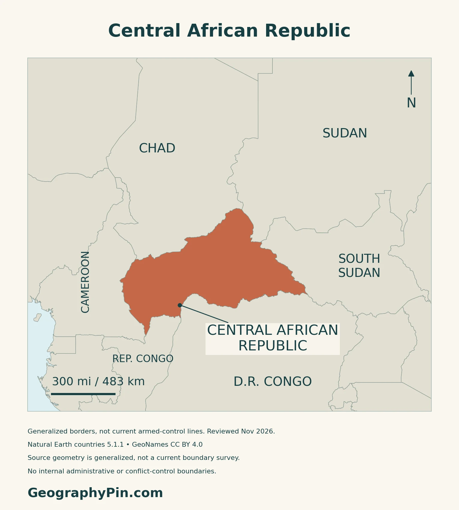
The Central African Republic is a country within central Africa, not another name for the entire region. It has no coastline. Cameroon lies to its west, Chad to its north, Sudan to its northeast and South Sudan to its east. The Republic of the Congo and the Democratic Republic of the Congo are its southern neighbors.
Bangui and the two Congos
Bangui is the national capital and seat of the country’s institutions. The two neighboring countries with “Congo” in their names are separate states; likewise, Sudan and South Sudan are separate neighbors.
2. Plateaus and Two Major Drainage Directions
Read the uplands before following the rivers
| Setting | Position | What to notice |
|---|---|---|
| Central plateau | Across the interior | Elevated terrain separating major drainage directions |
| Western uplands | Toward the Cameroon border | Yadé massif and adjoining higher ground |
| Eastern uplands | Toward the northeastern interior | Fertit and Bongo highland country |
| Southern river valleys | Along the Ubangi and Sangha systems | Connections into the Congo basin |
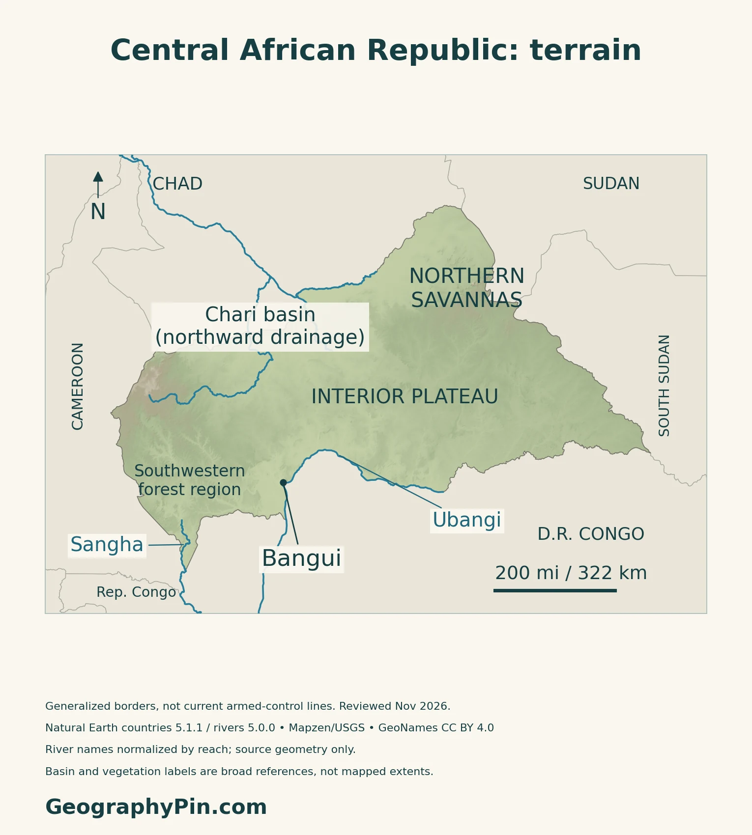
FAO’s 2005 AQUASTAT profile describes much of the central surface at roughly 1,300–2,600 feet (400–800 m), with higher massifs at its eastern and western ends. Plateau does not mean perfectly flat: river valleys, slopes and local hills interrupt the broad elevated surface.
A basin boundary is not a national border
The central drainage divide separates two large receiving systems. Northern catchments feed the Chari–Logone network toward Lake Chad; southern catchments feed the Congo system. The national frontier cuts across these hydrological connections rather than enclosing one self-contained basin.
3. Ubangi, Sangha and the Lake Chad Connection
Bangui’s river belongs to the Congo system
The Ubangi, also written Oubangui, forms where the Uele and Mbomou rivers meet. It runs west toward Bangui before continuing south into the Congo system. The Sangha is another Congo tributary, draining the southwestern borderlands. These are separate rivers within the same wider drainage network.
That distinction matters when reading a regional map: a river basin is the land contributing water to a river and its tributaries, not another name for a single channel. The dedicated Congo River guide follows the main river beyond this country.
Upstream of Lake Chad, without a lakeshore
The Lake Chad Basin Commission identifies Central African Republic headwaters feeding both the Chari and Logone sub-basins. Rivers such as the Ouham link the country’s uplands with the northward drainage system.
Being part of the Lake Chad basin does not give the Central African Republic a shore on the lake. The lake lies farther north, outside its territory.
A river connection is not a guarantee of year-round navigation
CICOS, the Congo–Ubangi–Sangha river commission, documents Bangui’s river-port role and the difficulty of navigating the Ubangi during low-water periods. Its 2015 infrastructure account describes historical interruptions and investment needs; it is not a live sailing schedule.
4. Seasonal Landscapes and Cross-Border Connections
Rainfall seasons lengthen toward the humid south
The World Bank’s 2021 climate-risk profile describes a humid tropical south and a progressively drier northeast. The dry season is longer in the north, while southern forest areas have a much longer rainy season. Elevation also modifies temperature.
Seasonal shifts in atmospheric circulation bring moist southwesterly air during the rains and drier northeasterly Harmattan conditions in the dry season. This broad pattern is more useful than assigning one rainy-season calendar to every town.
Two protected landscapes illustrate the contrast
In the southwest, Dzanga-Ndoki National Park forms the Central African Republic component of the Sangha Trinational World Heritage property. The other components are in Cameroon and the Republic of the Congo. UNESCO describes a connected landscape of tropical forest, wetlands and forest clearings.
The surrounding buffer zone includes the Dzanga-Sangha Forest Reserve. A buffer zone, a national park and the wider transboundary landscape are related but not identical boundaries.
Farther north, UNESCO’s account of Manovo-Gounda St Floris National Park emphasizes grassy floodplains, savannas, gallery forests and the Bongo sandstone massif. Together, these examples show why the country cannot be reduced to one continuous rainforest. They are landscape references, not assessments of current wildlife abundance or visitor access.
Landlocked geography makes neighboring routes important
The Douala–Bangui corridor links the country with Cameroon’s Atlantic gateway. In June 2026, the World Bank approved a phased program to rehabilitate infrastructure, improve road safety and strengthen maintenance along the corridor.
The Bank identified deteriorated roads and transport bottlenecks as constraints on trade. Access therefore depends on more than the distance to a port: road condition, border procedures and logistics shape the connection. Program approval is not the same as completion of all planned works.
5. Country Facts and Population Uncertainty
| Item | Reference | Date or scope |
|---|---|---|
| Capital | Bangui | Capital and institutional seat, Constitution Article 3 |
| Population | About 5.513 million | UN 2025 medium-fertility projection, not a new census count |
| Surface area | About 240,535 sq mi (622,984 km²) | UN reference, 2023; surface area |
| Official languages | French and Sango | 2023 Constitution, Article 1 |
| National language | Sango | A separate constitutional designation |
| Currency | Central African CFA franc (XAF) | Issued by BEAC |
| Government | Republic | 2023 Constitution, Article 1 |
A projection alongside a new census
The population figure above is the UN’s dated projection. It is not the result of the RGPH-4 census, whose digital enumeration took place in October–November 2025. In September 2026, the national statistics institute, ICASEES, reported that provisional census results were undergoing technical review. Its account explicitly withheld the population total pending approval by the national census commission.
ICASEES describes this as the first census since 2003 and records difficulties reaching some areas safely. No verified RGPH-4 national total is substituted here for the clearly labeled UN projection.
Languages and national institutions
The 2023 Constitution gives French and Sango official status and separately names Sango as the national language. It also recognizes the country’s other languages as part of its cultural heritage. Article 3 names Bangui as the capital and seat of national institutions.
The CFA franc used here is the BEAC-issued Central African currency, shared with other members of the Central African monetary union. It should not be confused with the separately issued West African CFA franc.
What Did We Learn Today?
The Central African Republic is one landlocked country within the wider Central African region. Its interior uplands help divide waters heading toward Lake Chad from those joining the Congo system. Bangui’s Ubangi setting and the Cameroon trade corridor connect the country outward, while southern forest and northern savanna landscapes show its environmental range. Census results and population projections must remain clearly distinguished.
Sources & Data Notes
Population figures are labeled by source, reference year and statistical type; a projection is not a census result. Historic FAO material supports stable landforms and drainage, not its obsolete population or administrative data. The 2021 climate profile describes long-term patterns, not current weather. CICOS’s 2015 account supports the historical relationship between low water and navigation, not a present sailing schedule. UNESCO descriptions are used for habitat and property scope, not current wildlife counts or visitor access. The June 2026 corridor announcement records approval, not completion of every planned improvement.
- UNData: 2025 projected population and 2023 surface-area reference
- ICASEES, 23 September 2026: provisional RGPH-4 results under technical review
- ICASEES, 4 October 2026: RGPH-4 data processing and October–November 2025 enumeration
- 2023 Constitution, original official Gazette: Articles 1 and 3
- BEAC: Central African CFA franc and monetary-union membership
- FAO AQUASTAT, 2005: stable plateau and drainage geography
- Yalibanda, 2004: forest-resource report, physical and river geography
- World Bank, 2021: climate-risk country profile
- Lake Chad Basin Commission, 2026 study terms: Chari and Logone geography
- CICOS, 2015: river infrastructure and low-water navigation
- UNESCO: Sangha Trinational property and buffer-zone scope
- UNESCO: Manovo-Gounda St Floris landscape
- World Bank: Douala–Bangui corridor program approval, June 2026
Map method: Original GeographyPin maps use public-domain Natural Earth countries version 5.1.1 and rivers version 5.0.0, plus GeoNames city locations under CC BY 4.0. River names are normalized by reach: the Ubangi begins at the supplied Uele–Mbomou confluence, while the displayed upper Sangha section is downstream of Nola. Only actual supplied linework is used; these are selected reaches, not complete headwater networks. FAO geography supports the broad drainage and vegetation orientation, without inferred basin or vegetation boundaries. Relief uses real Mapzen Terrain Tiles with Mapzen/USGS and upstream credits; heights are not summit measurements. WGS84 scales apply at their displayed latitude. Generalized borders are not current armed-control lines; November 2026 is a review date, not a survey date. The cover uses the Commons flag rendition, marked public domain, for editorial identification with a separate complete flag.