Barbados sits east of the Caribbean’s volcanic island arc, but it was not built as a volcanic cone. Its limestone terraces, northeastern Scotland District and contrasting coasts tell a different story. That geological difference also helps explain where rainwater goes and why some slopes are more difficult to build on than others.
Barbados is an independent island republic in the eastern Caribbean region, with Bridgetown as its capital. It lies east of the main volcanic island arc and is predominantly sedimentary, with uplifted marine rocks and a coral-limestone cover. The Scotland District exposes older rocks, while central uplands and Atlantic-facing coasts shape its physical geography.
How to use this article: Understand the island’s origin, locate the Scotland District, follow underground water, or check the population estimate’s scope.
1. Locating Barbados and Its Capital
East of the main island arc
On a regional map, Barbados stands apart from the curving chain of islands to its west. Saint Vincent lies to the west, Saint Lucia to the northwest, and Trinidad and Tobago farther southwest. The island’s exposed eastern coast faces the open Atlantic.
Barbados is geographically part of the Caribbean region and conventionally grouped within North America. Those regional labels do not make it geologically identical to every neighboring island. The Caribbean countries and territories map shows its position and independent status; the North American countries and capitals list supplies the wider continental context.
The country is centered on one main island rather than a widely scattered archipelago. Bridgetown is on the southwest side, in the parish of St. Michael. A parish is a territorial division within the country, not a separate island or country.

Start with Bridgetown on the map, then trace the rise toward the interior and the rougher terrain in the northeast. That sequence is more useful than treating the island’s coastline as a ring of identical beaches. Coast, elevation and underlying rock each describe a different part of the landscape.
2. Why Barbados Is Not a Volcanic Island
Sediments were raised, not piled into a volcanic cone
Barbados forms the exposed crest of an accretionary prism: a mass of sediments accumulated and deformed near a boundary where one tectonic plate descends beneath another. The term describes rock being scraped together and compressed, not lava building an island.
Marine sediments were folded, faulted and raised. Coral reefs subsequently grew over much of the shallower surface, leaving limestone terraces as the island continued to rise and sea level changed. The UWI Seismic Research Centre describes reef limestone as roughly 85 percent of the island’s exposed rocks.
That does not mean every rock is coral limestone. Older sedimentary formations remain exposed, especially in the Scotland District. Nor does the presence of occasional volcanic ash layers turn the island into a volcano: the origin of an island’s main structure is a different question from the origin of every thin deposit on it.
Terraces, gullies and the central uplands
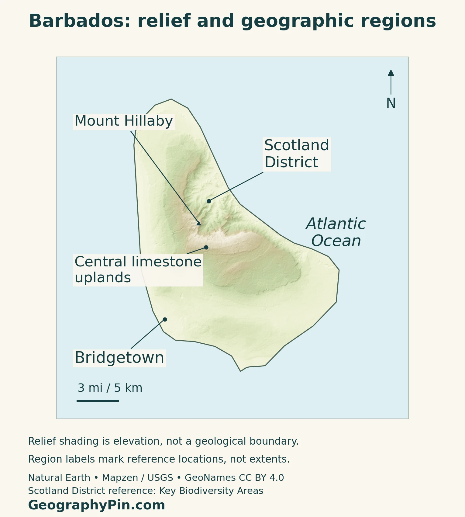
The limestone landscape rises in a sequence of broad terraces from the south and west toward the interior. Mount Hillaby marks the island’s highest ground near the edge of the Scotland District. Compared with the steep volcanic peaks of some neighboring islands, Barbados has modest elevations, but it is not flat.
Water moving through and over limestone creates caves, gullies and underground drainage routes. These features break up the apparently gentle terrain. A smooth-looking regional relief map cannot show every gully, sinkhole or abrupt local slope.
3. The Scotland District and Contrasting Coasts
Older rocks make a different landscape
The Scotland District occupies the northeastern part of Barbados, where older sedimentary rocks are exposed rather than hidden beneath the extensive coral cap. Its broken slopes, ridges and valleys contrast with the broader limestone terraces elsewhere.
Clay-rich materials and steep ground help explain its recurring landslides. University of the West Indies material describes how increasing water pressure can weaken these slopes during wet conditions. Roads can be undermined or blocked by moving earth, so drainage and slope stability matter to settlement and maintenance.
The district is a physical and geological region, not an additional parish. The labeled reference on the map identifies its general location; it does not draw a cadastral boundary or imply that all ground inside one parish has the same geology.
| Setting | Characteristic | Why it matters |
|---|---|---|
| Limestone terraces and central uplands | Raised coral limestone, with gullies and underground drainage | Water can enter aquifers rather than remain in long surface rivers |
| Scotland District | Older exposed sediments and broken slopes | Slope movement affects land use and roads |
| Eastern coast | Open Atlantic exposure | Wave energy helps shape a more exposed shoreline |
| Western and southern coasts | Generally more sheltered coastal settings | Urban and visitor development coexist with erosion and swell exposure |
“Sheltered” is relative. The Coastal Zone Management Unit explains that winter swells generated by distant North Atlantic storms can strongly affect the normally lower-energy west coast. The island’s western side is not immune to large waves simply because it is often calmer than the east.
Coastal contrasts change over time as storms, currents and sediment movement reshape beaches. A general geography map is not a forecast of conditions at any particular beach.
4. Rainfall and the Water Beneath the Island
An aquifer connects inland land use to the coast
Barbados has a tropical maritime climate with a wetter and a drier part of the year. The Caribbean Regional Climate Centre’s airport record for 1971–2014 places the wettest three-month period, on average, in September–November and the driest in February–April. That is a station-based historical pattern, not a forecast or an exact calendar for every year.
Much of the useful freshwater is stored underground. An aquifer is rock or sediment that holds and transmits water; in Barbados the limestone allows rain and runoff to enter an extensive groundwater system. Many surface channels carry water only intermittently.
Karst features such as sinkholes and caves can provide rapid routes into this system. Research described by University College Cork shows why runoff carrying pollutants can reach groundwater without the slow passage through rock that people may imagine. The same groundwater can eventually discharge near the coast, connecting inland activities with marine environments.
Recharge means water entering and replenishing an aquifer. Jones and Banner’s research on Barbados found that the seasonal concentration of rain helps determine recharge, not just the annual rainfall total. Two years with similar overall rain can therefore have different implications for stored water.
Water planning involves more than deciding whether the island looks wet or dry. Where rain falls, how it enters the ground, and what land uses occur along those pathways all matter. A lack of large permanent surface rivers does not mean a lack of water movement.
5. People, Bridgetown and Country Facts
| Item | Reference |
|---|---|
| Capital | Bridgetown, in southwestern St. Michael; national government seat |
| Resident population | 269,090 estimated in the final 2021 census report, reference date August 1, 2021 |
| Surface area | About 166 square miles (431 square kilometers), UN reference for 2023 |
| Language | English |
| Currency | Barbados dollar (BBD); BBD 2 = USD 1 |
| Government | Parliamentary republic; president is head of state and prime minister heads government |
| Territorial divisions | 11 parishes |
The census report figure is an estimate
The Barbados Statistical Service’s final 2021 census report estimated 269,090 residents. It did not enumerate everyone: coverage gaps required an estimate using a previous population base adjusted for births, deaths and migration. The figure should not be described as a complete headcount or a present-day total.
Bridgetown city, St. Michael parish and the national population are different statistical units. This profile does not substitute a parish count for the capital. Much settlement extends along the western, southern and southeastern coastal areas rather than stopping at the historic city core.
UNESCO’s Historic Bridgetown and its Garrison property combines the old town with a nearby former military garrison. Its maritime-trade history included sugar and the trafficking of enslaved people. That designated heritage area is not a boundary for the whole modern urban population.
Barbados became independent from Britain in 1966 and a republic on November 30, 2021. The change to a president as head of state was not a new independence date. The prime minister leads the government within a parliamentary system.
The area figure above is the UN surface-area series, not a measurement of maritime jurisdiction. Small variations among published island-area references should not be turned into a supposed inland-water area by subtracting incompatible numbers.
6. Land Use and Economic Connections
Barbados’s economy depends heavily on tourism and services, including business services. The World Bank’s October 2026 country assessment also identifies exposure to imported goods, external demand and climate shocks. Ports, air connections and reliable utilities are therefore important to daily economic life as well as to visitors.
The national Land Degradation Neutrality report describes development pressures where residential and commercial surfaces replace cropland or grassland. On a small island, these are not separate conversations: housing, agriculture, transport, water recharge and ecosystem protection compete for overlapping spaces.
Geology adds another layer to those choices. A road across stable-looking limestone terrain may cross gullies or underground voids; a route through the Scotland District may face slope movement; coastal development must account for erosion and waves. These are different constraints, so one island-wide label cannot describe every building site.
Barbados also remains exposed to regional events beyond its shores. The World Bank records damage to fisheries and port infrastructure from Hurricane Beryl in 2024. Location outside the main volcanic arc does not remove the need to understand storms, ocean conditions and connections with neighboring islands.
Frequently Asked Questions
Why can Barbados receive volcanic ash if it is not volcanic?
Wind can carry ash from another island’s eruption. Barbados experienced ashfall from La Soufrière on Saint Vincent in 2021. That was material arriving from a neighboring volcano, not evidence that Barbados itself had erupted.
Is Barbados the same place as Barbuda?
No. Barbados is an independent country. Barbuda is one of the main islands of the separate country Antigua and Barbuda, farther north in the Lesser Antilles. The similar names do not identify the same state.
What Did We Learn Today?
Barbados’s geography is best read through its contrasts: limestone terraces and groundwater routes, older exposed rocks in the Scotland District, and coasts with different wave exposure. Bridgetown’s southwestern position and the island’s concentrated development add a human pattern to that physical landscape. Understanding those differences is more useful than calling the whole island either flat, volcanic or simply a beach destination.
Sources & Data Notes
The population figure is the final census report’s resident estimate for August 1, 2021, not a complete enumerated count. Area follows the UN’s 2023 surface-area reference. Historical geological and rainfall sources describe processes and climatology, not current hazards or forecasts. The physical map labels reference locations, not surveyed geological boundaries.
- Barbados Ministry of Energy: tectonic setting and limestone terraces
- UWI Seismic Research Centre: sedimentary origin, limestone cover and separation from the volcanic arc
- FAO: physical regions, limestone terraces and gullies; historical background used for stable landforms
- University of the West Indies: landslide processes in the Scotland District; historical synthesis
- Coastal Zone Management Unit: winter swells and contrasting coastal exposure
- Caribbean Regional Climate Centre: airport rainfall record, 1971–2014
- University College Cork (2022): groundwater research and karst pathways in Barbados
- Jones and Banner (2003): rainfall and recharge of the Barbados limestone aquifer
- Barbados Statistical Service: final 2021 census report, Tables A and C
- UNData: Barbados country profile and surface-area reference
- Parliament of Barbados: republican transition and parliamentary institutions
- Government International Business Unit: language and parishes; not used for dated economic or political-officeholder details
- Central Bank of Barbados Act 2020-30: sections 33–34, currency and parity
- UNESCO: Historic Bridgetown and its Garrison
- Barbados Land Degradation Neutrality report, May 2023: settlement and land-use patterns
- World Bank: Macro Poverty Outlook, October 2026, Barbados country section
- World Bank: Barbados overview, including Hurricane Beryl impacts
Map method: Original GeographyPin maps use public-domain Natural Earth land geometry and GeoNames place coordinates under CC BY 4.0, reprojected and labeled. Relief derives from Mapzen Terrain Tiles with USGS elevation data. Shading represents elevation, not rock type. The Scotland District pointer uses a Key Biodiversity Areas reference location; the central limestone-uplands pointer uses Harrison’s Cave as a reference. Neither is a mapped geological boundary. The featured flag-filled island outline is decorative cartography, not a maritime jurisdiction map.
