The best Everglades entrance depends on what you want to do, not which pin a map app puts closest to you. The roads at the three entrances do not join inside the park, so choosing the wrong one can mean a long drive back out.
Use the Homestead entrance for the short Anhinga Trail at Royal Palm or the drive to Flamingo. Enter Shark Valley from U.S. 41 for the marsh loop by foot, bicycle or tram. Go to Everglades City for the Gulf Coast and the Ten Thousand Islands by water. You cannot drive from Shark Valley to Flamingo inside the park.
How to use this article: Compare the three starting points, work out the Homestead return drive, or see how to switch entrances.
Choose the right Everglades entrance
Pick the landscape first
If you have time for just a short walk, pick a trailhead, not the park as a whole. For an open marsh outing or a boat trip, choose the entrance that serves that activity. Flamingo is at the end of the park road, not a fourth drive-in entrance.
| If you want | Start here | How you continue |
|---|---|---|
| A short marsh walk, or a drive from the marsh to Florida Bay | Homestead entrance / Ernest F. Coe Visitor Center via State Road 9336 | Drive to Royal Palm for the 0.8-mile (1.3 km) Anhinga Trail round trip. For the bay, drive farther down Main Park Road to Flamingo. |
| Open sawgrass and a broad view from the observation tower | Shark Valley Visitor Center via U.S. 41 / Tamiami Trail | Leave the car by the entrance. Continue by tram, bicycle or on foot on the 15-mile (24 km) loop. |
| A mangrove island or estuary trip from the Naples side | Marjory Stoneman Douglas Visitor Center in Everglades City via Route 29 | Finish the drive at the waterfront and use a confirmed boat trip or suitable water access. There is no road across the islands. |
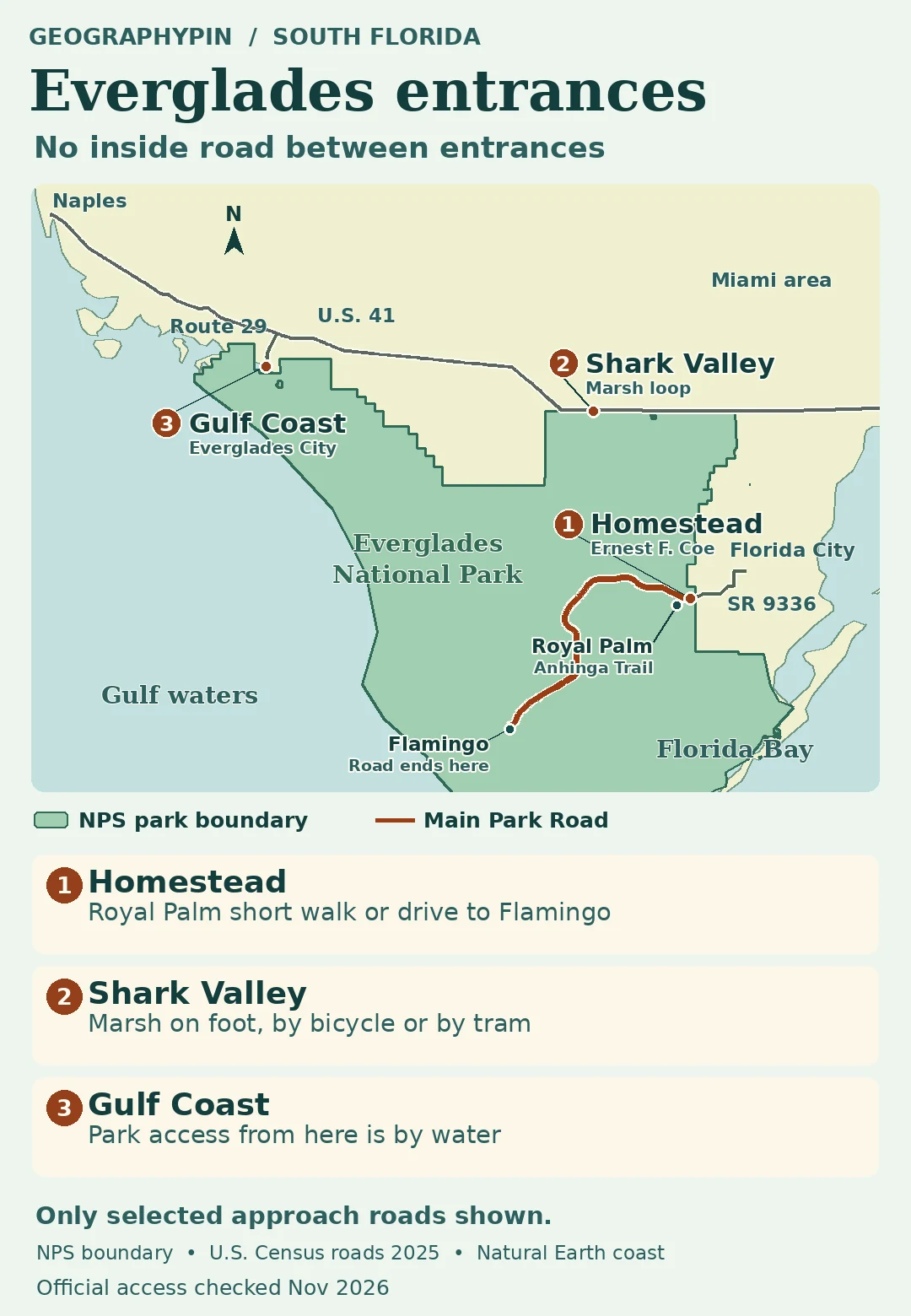
Homestead: A short walk or a longer drive to Flamingo
The trail mileage is not the road mileage
From Florida City, follow Palm Drive, State Road 9336, west to the main entrance and the Ernest F. Coe Visitor Center. Royal Palm is about 4 miles (6 km) inside the park by road. That is where the Anhinga Trail starts. Its 0.8-mile (1.3 km) figure is the walk from the trailhead and back, not the drive from the gate.
To see Florida Bay, follow Main Park Road the rest of the way to Flamingo and the Guy Bradley Visitor Center. The National Park Service lists about 38 miles (61 km) from the main entrance to Flamingo one way. Return along the same road and the entrance-to-Flamingo portion is about 76 miles (122 km) before side trips, or the drive back to your hotel.
Shark Valley: The loop is not a through road
Turn off U.S. 41, also called Tamiami Trail or Southwest 8th Street, at Shark Valley. The parking area is only the start. The paved loop crosses the marsh and reaches the observation tower near its halfway point, but private cars cannot continue beyond the entrance road and parking area. A bicycle or tram can make the full loop practical if you don’t want to walk it.
Don’t confuse a route along Tamiami Trail with the park’s tram route. U.S. 41 connects communities outside the gate; the marsh loop returns to Shark Valley and never reaches the southern park road. Check the park’s current access notes before committing to a scheduled tram, particularly when winter traffic is heavy.
Everglades City: The Gulf Coast is a boat trip
Follow Route 29 south to Everglades City and the Marjory Stoneman Douglas Visitor Center at 815 Oyster Bar Lane. Some older maps call this the Gulf Coast Visitor Center. You can drive to the waterfront, but the surrounding mangrove islands and waterways are reached by boat, not by a continuation of that road.
Checked November 22, 2026: The National Park Service identifies the new visitor center as open and lists a kayak launch at the site. Check the center’s current page for launch or facility changes and confirm any boat tour before you make the trip. Use the park’s official boating maps and conditions for a water outing; this road-access map does not show channels or navigable routes.
Changing entrances and checking seasonal access
Switch entrances on public roads outside the park
To go from Shark Valley to Flamingo, return to U.S. 41 and reach the Homestead entrance from the Florida City side before taking Main Park Road. To switch from Shark Valley to the Gulf Coast, use U.S. 41 west to Route 29. Neither trip is a shortcut through the park. If time is tight, pick one area instead of trying all three.
The park’s winter 2026–27 announcement says its full seasonal program starts December 19. Published visitor-center hours, gate hours and tour hours can differ. Check NPS Alerts & Conditions and your specific entrance or visitor center on the day. If you’re relying on the limited city trolley to Royal Palm, verify your exact date on the City of Homestead calendar rather than assuming winter service.
Frequently Asked Questions
Can I drive from Shark Valley to Flamingo inside the park?
No. Drive out to the public road system and enter at Homestead, then follow Main Park Road to Flamingo. The Shark Valley loop is not open to private cars beyond the entry area.
Which park map or alert should I check before arriving?
Use NPS Directions for the correct starting address, and NPS Alerts & Conditions for closures. If you’ll go on the water, check the separate boating materials on the park’s Maps and Navigation page.
Does the drive distance to Flamingo include the return?
No. The park’s 38-mile (61 km) distance is from the Homestead entrance to Flamingo one way. Driving back to that entrance makes it about 76 miles (122 km), before side trips.
What Did We Learn Today?
Choose Homestead for Royal Palm and Flamingo, Shark Valley for the marsh loop, or Everglades City for the mangrove waterways. The entrances do not connect inside the park, so plan the outside drive and the return before picking a trail or booking a tour.
Sources & Data Notes
Open sources & map notes
- National Park Service, Everglades directions, updated October 5, 2026: addresses, road approaches, disconnected entrances and 38-mile one-way drive. Royal Palm directions and Anhinga Trail distinguish vehicle and walking distances.
- NPS Shark Valley Visitor Center: private-vehicle limits, full loop distance and observation tower. NPS Gulf Coast visitor center: boat access and current site status. NPS Maps and Navigation provides separate official boating materials.
- NPS winter 2026–27 announcement, November 17, 2026 and NPS alerts were checked November 22, 2026. No schedule or road access is guaranteed by this map.
- Map: NPS public-domain park boundary, unit EVER; selected roads from the U.S. Census Bureau 2025 road files; generalized coastline from Natural Earth. Not a navigation chart, jurisdiction survey or picture of a closure.
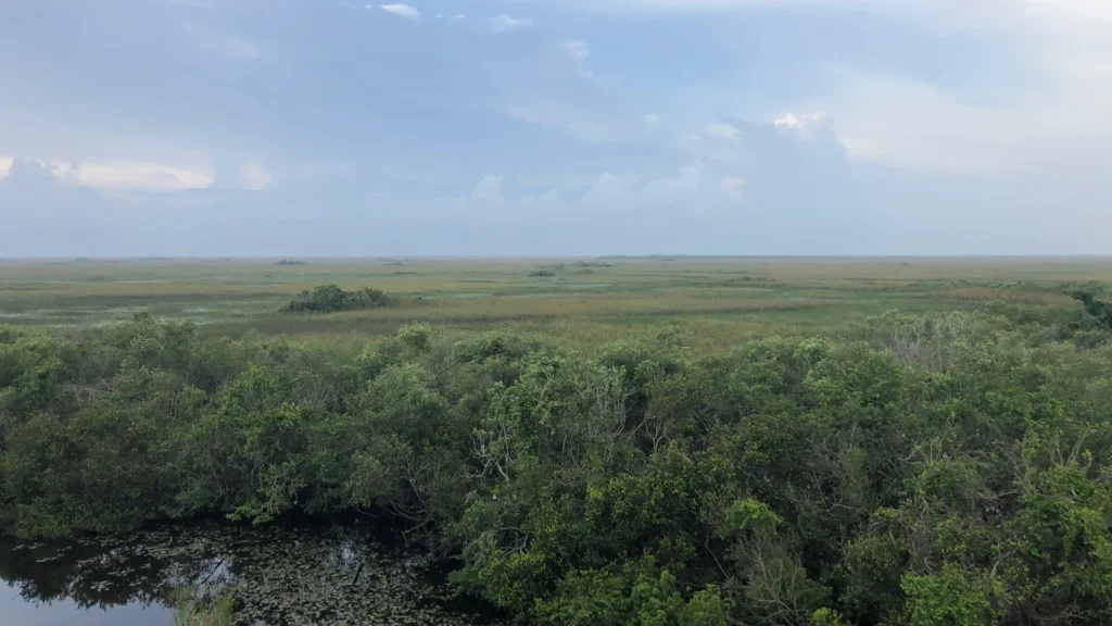
- Cover: NPS photograph by G. DeFalco, Shark Valley from the observation tower, May 31, 2018. U.S. federal public domain; cropped and resized.