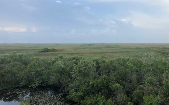
Two overlooks on the same stretch of Skyline Drive can face completely different landscapes. One looks across the Shenandoah Valley; the next looks down the opposite slope toward Virginia’s foothills. Choose the view first, then use the milepost to find the best entrance.
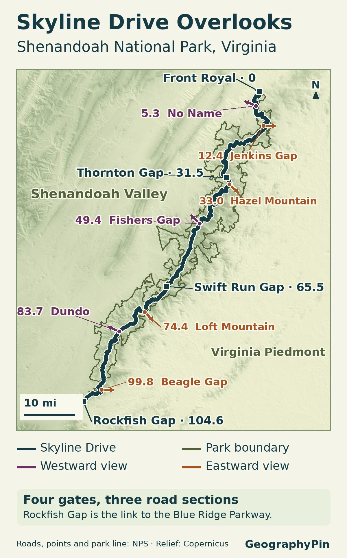
Skyline Drive follows the Blue Ridge for about 105 miles through Shenandoah National Park. For a westward view into the Shenandoah Valley, try No Name Overlook at mile 5.3 or Fishers Gap at mile 49.4. For the eastern foothills and Piedmont, try Jenkins Gap at mile 12.4 or Loft Mountain at mile 74.4.
How to use this article: Check the route map, compare which way each viewpoint faces, then work out the drive back or the next exit.
Follow the ridge between the four entrances
The road curves; the numbers always increase southbound
Skyline Drive runs along the Blue Ridge in Virginia, with the broad Shenandoah Valley to the west and the foothills that meet the Piedmont on the east. The road winds too much to judge the view just by looking at which side of the car the pullout is on. The arrows on the map show published view directions, not turns you need to make.
Only four public vehicle entrances reach the drive. From north to south they are Front Royal (mile 0, near I-66 and US 340), Thornton Gap (31.5, US 211), Swift Run Gap (65.5, US 33), and Rockfish Gap (104.6, I-64 and US 250). Rockfish Gap also connects to the separate Blue Ridge Parkway. These four points give you three sections to plan around, rather than one drive you have to finish end to end.
Choose an entrance without doubling the drive
Two ways to use the same mileposts
| If you want | Drive | Mileage to allow |
|---|---|---|
| A short north-end visit with both views | Front Royal to No Name and Jenkins Gap, then retrace the drive. | About 12.4 mi (20.0 km) each way from mile 0, or about 25 mi (40 km) total. |
| A central through-drive ending near US 33 | Thornton Gap to Hazel Mountain and Fishers Gap, then go out at Swift Run Gap. | About 34 mi (55 km) on Skyline Drive. Do not double it if you leave via US 33. |
From the Rockfish Gap entrance at mile 104.6, McCormick Gap Overlook at mile 102.4 is about 2.2 road miles (3.5 km) north. It looks over the southern Shenandoah Valley. Beagle Gap, one of the stops listed below, is about 4.8 miles (7.7 km) from the entrance by milepost. Neither figure includes the approach from town.
Seven overlooks and the views they face
Pick a roadside view, not a trailhead
These are roadside overlooks with parking, not summit hikes. The directions use the National Park Service descriptions. A westward view may look across a broad valley or only through a gap in the trees. On the eastern side, a view of a nearby ridge is different from a view all the way out into the Piedmont.
| Milepost and overlook | Faces | What to look for |
|---|---|---|
| 5.3 No Name | West-northwest | Shenandoah Valley, split by Massanutten Mountain |
| 12.4 Jenkins Gap | East | A narrow opening to the Piedmont over the Bolton Branch hollow |
| 33.0 Hazel Mountain | Southeast | Blue Ridge foothills and nearby granodiorite rock |
| 49.4 Fishers Gap | Northwest | Shenandoah Valley through a narrow opening, Massanutten beyond |
| 74.4 Loft Mountain | Southeast | The ridge descending into the Piedmont foothills |
| 83.7 Dundo | West-northwest | Valley and ridges in the direction of Massanutten |
| 99.8 Beagle Gap | East | Calf Mountain and the Virginia Piedmont beyond the park |
What the milepost does not tell you
The milepost is a road reference, not a walking distance. For example, the Stony Man trail starts near mile 41.7 but reaches its summit viewpoint on a 1.6-mile (2.6 km) round-trip hike. A roadside pullout and a nearby summit can have similar names and very different effort. The official area map can tell you whether it shows a parking lot, a trailhead or the viewpoint itself.
After Thornton Gap, the drive passes through Marys Rock Tunnel at mile 32.2 before Hazel Mountain. The park lists a maximum clearance of 12 feet 8 inches (about 3.86 m). If you are in a tall vehicle, check your full height before choosing a route through it.
Check the road and facilities separately
Practical information checked: November 21, 2026.
The NPS says a clear-day drive along the full roughly 105 miles (169 km) takes about three hours, before longer stops. Weather can close individual sections on short notice. The park directs drivers to its current alerts rather than the old road-status phone line. You can also sign up for the park’s text alerts if you expect conditions to change during the trip. Look up the exact section between your entry and planned exit before committing to a through-drive.
A road can be passable when a visitor center, wayside or campground is closed for the season. Check the park’s facility operating dates separately if you need restrooms, food or other services. A backcountry or trail closure does not automatically close the paved drive.
Frequently Asked Questions
Where are the physical mile markers?
The markers stand on the west side of Skyline Drive. They are on your right when you drive south and on your left when you drive north. They do not indicate which way the nearby overlook faces.
Does a west-facing overlook guarantee an open sunset view?
No. The view direction describes the opening from the overlook, not an unobstructed horizon. Ridge shape, growing trees, fog and the season can change what you see. The park describes Fishers Gap, for example, as a narrow opening rather than a wide panorama.
What Did We Learn Today?
Use viewing direction to choose a stop, mileposts to estimate driving distance, and the four gates to decide whether you will retrace the road or drive through. An overlook, a summit hike and a road segment can all have different access conditions on the same day.
Sources & Data Notes
Distances use differences between NPS road mileposts, rounded where appropriate. They exclude drives in from other highways and walking inside viewpoints. The mapped arrows represent reference directions, not the full horizontal range of views.
- National Park Service: Skyline Drive access, mileposts and travel time, alerts and facility seasons.
- NPS overlook profiles: No Name, Jenkins Gap, Hazel Mountain, Fishers Gap, Loft Mountain, Dundo and Beagle Gap. NPS: Stony Man trailhead and walking distance.
- Map by GeographyPin, using NPS public roads, NPS public points of interest, NPS legislative boundary, 2016, and modified Copernicus DEM data accessed in 2026.
- Featured photograph: NPS/Shenandoah National Park, Skyline Drive in fall, cropped and converted to WebP.
- NPS: McCormick Gap Overlook, mile 102.4.