The Blue Ridge Parkway runs roughly 469 miles (755 km) from Rockfish Gap in Virginia to the edge of Great Smoky Mountains National Park in North Carolina. For a day trip, choose the stretch that contains your stop and check the roads at both ends before counting on a through drive.
A short closure can force a long bypass because the gate is not necessarily next to a public road. Find the last usable junction before the closure and the first usable junction beyond it, then follow the signed detour. The distance between the closed mileposts measures the blocked Parkway segment, not the distance your car will travel.
How to use this article: Try the milepost map, see the highlands section, or go to the dated access check.
Choose your section by milepost and access road
The map, then the road-status table
Mileposts increase as you follow the Parkway from the Shenandoah end toward the Smokies, though the road twists and sometimes points another way. Use them to put stops in order. Then find both the entry and the exit in the current National Park Service road table. A state or U.S. highway crossing without an interchange is not necessarily an entry point.
| Your plan | First access road to check | What can change |
|---|---|---|
| Short drive from the Shenandoah end | Rockfish Gap / US 250, MP 0 | Check the road south to Humpback Rocks (MP 5.8). Skyline Drive is a different road north of the gap. |
| A central Virginia drive near Roanoke | US 460, MP 106; exit at US 220, MP 121.4 | About 15.4 Parkway miles (25 km) between the junctions. Stop at Roanoke River Overlook if the road and pullout are open. |
| A half day in the North Carolina highlands | US 321 near Blowing Rock, around MP 292 | Check the line to Linn Cove (MP 304) and the US 221 access at Beacon Heights near MP 305.1. A road being open does not mean its visitor center is open. |
| Arrival near the Smokies | US 19 at Soco Gap, MP 455.7, or US 441 at the southern end, about MP 469 | Check the southern Parkway and Great Smoky Mountains National Park road reports separately. If the Parkway is closed, do not route through its gates. |
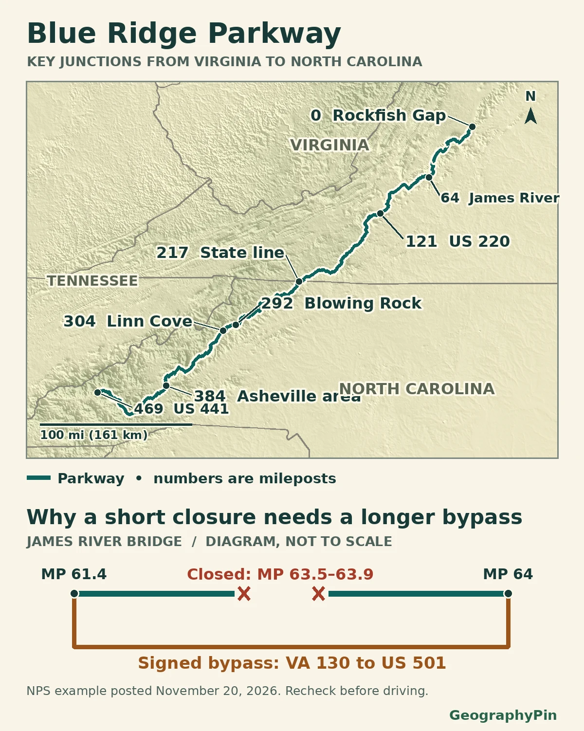
These areas are planning choices, not official park districts. A day drive can cover part of one area and return to the same junction. The point is to identify connected roads, not to complete an arbitrary distance.
The Shenandoah end: Rockfish Gap and Humpback Rocks
The two scenic roads meet but have different mileposts
Start on the Parkway at Rockfish Gap near Waynesboro, Virginia, signed from US 250 and accessible from I-64. Skyline Drive heads north from the gap into Shenandoah National Park; the Blue Ridge Parkway heads south and starts its own milepost sequence at zero. Check different road reports if you plan to use both.
Humpback Rocks Visitor Center is at MP 5.8; the nearby Humpback Gap parking area and trail are a separate stop around MP 6. Mileposts are driving references, not hiking distances. Farther south, US 220 gives access near MP 121.4 in the Roanoke area. You do not have to start at MP 0 to reach a Virginia stop.
The North Carolina highlands: Blowing Rock and Linn Cove
Use the nearby highway junctions, not the bridge itself
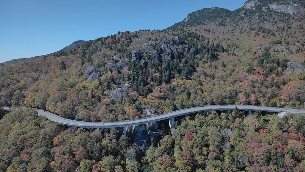
For the Grandfather Mountain stretch, start by checking the US 321 connection near Blowing Rock (around MP 292) or US 221 at Beacon Heights (MP 305.1 in the road-status table). Linn Cove Viaduct is around MP 304 between them. Do not stop on the bridge or try to cross it on foot; use signed overlooks or designated trails when open.
Check the Linn Cove Visitor Center, parking and trails separately. The park’s November 20 road table listed short single-lane works in the MP 291.8–305.1 area and the visitor center temporarily closed. That example is different from a full road closure, and neither status applies automatically on another day.
The Smokies end: Asheville, Soco Gap and Cherokee
Pick a junction before the last stretch of Parkway
South of the Asheville area, use known public junctions to shorten the route: US 276 near MP 412, US 23/74 at Balsam Gap near MP 443, or US 19 at Soco Gap (MP 455.7). The final junction is US 441, known as Newfound Gap Road in Great Smoky Mountains National Park, near Cherokee. Check that park’s status independently before planning to continue over the mountains.
Think of Soco Gap as an alternate entry or exit only while its connecting Parkway section is open. The highway junction still exists even if the gate beyond it is closed, and an open road into Cherokee does not prove the final Parkway stretch is usable.
What changes with closures or seasonal access
A dated route check: November 20, 2026
In its 2:32 p.m. November 20 table, checked November 21, the National Park Service listed the James River Bridge closure at MPs 63.5–63.9. That covers 0.4 Parkway mile (0.6 km). The signed detour left at MP 61.4, took VA 130 and US 501, and reentered at MP 64. The 2.6 Parkway miles (4.2 km) between exit and reentry are not the distance along those other roads.
That same bulletin listed weather closures from Beech Gap (NC 215, MP 423.2) through Balsam Gap and Soco Gap to the southern terminus (MP 469.1). It also listed a separate Helene-related closure from NC 80 at MP 344.2 to Mount Mitchell State Park at MP 355.3. A spell of better weather would not by itself reopen a repair zone.
Read the notes beside each row, not just the status cell: the James River row, for example, contained an explicit closed interval inside a broadly open section. At this check the NPS maps page said its LiveMap was not showing current closures. Use the dated text table and posted road signs, and never go around a closed gate.
Frequently Asked Questions
How do I find the roads to leave and rejoin around a closure?
Use the access-road and notes columns in the NPS road table for the specific closed interval. For James River Bridge in the November 20 example, the park named VA 130 at MP 61.4, US 501 and reentry at MP 64. Elsewhere, start with the published roads for that closure, not a shortcut offered by a map app.
Where do Blue Ridge Parkway mileposts restart after Skyline Drive?
At Rockfish Gap near Waynesboro. Skyline Drive’s own mileposts end near the gap. The Blue Ridge Parkway starts a separate count at milepost 0 and the numbers rise as you travel south. Check each road’s conditions separately if you drive both.
Can a Parkway section be open while an overlook building is shut?
Yes. The road, a parking area or trail, and a visitor center can have separate schedules and closures. The Linn Cove center was listed as temporarily closed even while its stretch was listed open with short lane closures in the November 20 bulletin.
What Did We Learn Today?
Plan the Parkway from the access roads inward. Mileposts put the sights in order, but the road-status notes tell you whether you can connect them. Before committing to a through drive, know where you can get off and whether you can actually get back on.
Sources & Data Notes
Geographic map uses the physical NPS centerline and approximate NPS/SEAC milepost points; the state-line and southern labels are rounded for readability. Closure diagram is intentionally not to scale and is a snapshot of the signed James River example on the 2:32 p.m. November 20 bulletin, verified November 21, 2026. Neither panel is live navigation.
- NPS: gate-by-gate road status, dated rows, weather and work exceptions
- NPS: park maps, LiveMap notice and signed James River detour
- NPS: verified major public approaches and named routes
- NPS: Rockfish Gap and Cherokee termini
- NPS: James River Bridge closure and sequence via VA 130 and US 501
- NPS: Humpback Rocks and Linn Cove facilities
- NPS: Linn Cove overlook and walking guidance
- Great Smoky Mountains National Park: separate road-status check
- NPS: main road geometry, Blue Ridge Parkway line 16662
- NPS / Southeast Archeological Center: approximate milepost points
- Natural Earth: state boundary lines, public domain
- Mapzen elevation tiles with U.S. source credit
- Featured image: Linn Cove Viaduct, NPS flight photograph, October 7, 2024; U.S. public domain, cropped and resized
- NPS Parkway access mileposts; Roanoke River Overlook.